Lillie Bridge (Fulham)

Last updated

Lillie Bridge
Lillie Bridge into Fulham.jpg
Lillie Bridge from West Brompton station
Coordinates 51°29′N0°12′W / 51.49°N 0.2°W / 51.49; -0.2
Carries A3218 road
Crosses West London Line
Locale London, England, United Kingdom
Characteristics
Design Road bridge
MaterialSteel and brick
History
Designer Sir John Fowler, 1st Baronet
Opened1860
Location
Lillie Bridge (Fulham)
West London Railway 1850, indicating the extant steps to basin at Lillie Bridge West London Railway 1850.gif
West London Railway 1850, indicating the extant steps to basin at Lillie Bridge

Lillie Bridge is a road bridge that links Old Brompton Road in the Royal Borough of Kensington and Chelsea with Lillie Road in the London Borough of Hammersmith & Fulham. It crosses two railways: the West London Line on the London Overground and the Wimbledon branch of the London Underground at West Brompton station.

Contents

History

Its history goes back to at least the 18th-century when there was a wooden foot-bridge, called 'Gunter's Bridge' after landowner and confectioner James Gunter (1731-1819), over a tributary of the River Thames, variously called Counter's Creek, or Counter's ditch (or sewer), that separated the parishes of Fulham and Kensington at this spot. [1] A Magistrates' enquiry into the bridges of the County of Middlesex, set up in 1820, described it thus:

Footbridge of Wood called Gunter's Bridge in the Footpath between Earls Court and Walham Green. [...] This bridge has been built upwards of Fifty Years and is kept in repair at the joint expense of Kensington and Fulham Parishes. [...] The tide flows to a considerable distance above this Bridge. [2]

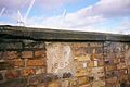
A stone and brick structure was built in its place, when Counter's Creek was converted into the Kensington Canal in 1826. [3] It opened for trade in 1828. Remnants of the bridge beneath the current road bridge are still visible from platform 4 on the Overground Line at the neighbouring station. The new bridge was subsequently named after Sir John Scott Lillie, the Peninsular War veteran and inventor and early 19th-century developer on the Fulham side, who was also involved with the canal project. Its railway associations go back to 1838 under the supervision of engineer, Robert Stephenson. The canal bridge was used to carry the road over the railway to the London and North Western Railway yard which had replaced the canal basin and wharves behind Reckitt Street, Fulham. [4]

Remaining arch of 'Lillie' 's 1826 Kensington Canal bridge Lillie Canal Bridge.jpg
Remaining arch of 'Lillie' 's 1826 Kensington Canal bridge
Steps onto 1826 Canal bridge at West Brompton, Fulham side Gunter's Lillie Bridge, 1826.jpg
Steps onto 1826 Canal bridge at West Brompton, Fulham side

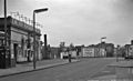
A new much enlarged road bridge was built over the stone and brick canal crossing in 1860 by the railway engineer, John Fowler in connection with his construction of the Grade II Listed West Brompton station. [5] [6] Since then. the bridge became known for the sporting venues to the south, as the 'Lillie Bridge Grounds' opened in 1869 and closed by arson and a riot in 1887. [7] It was the scene of athletics, football and county cricket, as well as cycling and ballooning. To the north it has become associated with the eponymous Lillie Bridge Depot, built in 1871 as an engineering hub for the early railways and latterly, a maintenance centre for London Transport's tube network. [8] Fowler's bridge has been lengthened and strengthened in ensuing years. The brickwork in the original parapets has been repaired but the four stone plaques commemorating the dates of re-building, from 1860 onwards, are retained in the present bridge. Both parapets were obscured for decades by tall advertising hoardings only taken down since 2012 for the Olympic Games, when Indoor volleyball was played at Earl's Court. [9]

Green corridor

In spite of repeated disturbance since the early 19th-century, with canal and railway building, the verges of the West London Line and the proximity of Brompton Cemetery and the town gardens of Empress Place in Fulham, had ensured the survival of a rich biodiversity in the area of the bridge. Most notably there is a pond, remnant of the ever-present Counter's Creek, along platform 4 of West Brompton station on the Fulham side. The pond and its acre of 'scrub' was, until 5 years ago, supervised by the erstwhile Railtrack and local volunteers from Fulham Groundwork UK. The defunct London Ecology Unit produced in 1993 an audit of the flora and fauna to be found here. There are said to have been 140 species of flora. [10] In 2016 the Bee Friendly Trust installed on platform 2 of the District line at West Brompton station, a number of flower boxes to attract pollinating insects.

Future prospects

Lillie Bridge, along with the borough boundary, the natural 'Green corridor' and built heritage, are scheduled to disappear in the regeneration plans for the Earls Court Exhibition Centre site. [11]

Related Research Articles

<span class="mw-page-title-main">District line</span> London Underground line

The District line is a London Underground line running from Upminster in the east and Edgware Road in the west to Earl's Court in west London, where it splits into multiple branches. One branch runs to Wimbledon in south-west London and a short branch, with a limited service, only runs for one stop to Kensington (Olympia). The main route continues west from Earl's Court to Turnham Green after which it divides again into two western branches, to Richmond and Ealing Broadway.

<span class="mw-page-title-main">Fulham</span> Area of west London, England

Fulham is an area of the London Borough of Hammersmith & Fulham in West London, England, 3.6 miles (5.8 km) southwest of Charing Cross. It lies on the north bank of the River Thames, bordering Hammersmith, Kensington and Chelsea. The area faces Wandsworth, Putney, Barn Elms and the London Wetland Centre in Barnes. on the far side of the river.

Earl's Court is a district of Kensington in the Royal Borough of Kensington and Chelsea in West London, bordering the rail tracks of the West London line and District line that separate it from the ancient borough of Fulham to the west, the sub-districts of South Kensington to the east, Chelsea to the south and Kensington to the northeast. It lent its name to the now defunct eponymous pleasure grounds opened in 1887 followed by the pre–World War II Earls Court Exhibition Centre, as one of the country's largest indoor arenas and a popular concert venue, until its closure in 2014.

South Kensington is a district just west of Central London in the Royal Borough of Kensington and Chelsea. Historically it settled on part of the scattered Middlesex village of Brompton. Its name was supplanted with the advent of the railways in the late 19th century and the opening and naming of local tube stations. The area has many museums and cultural landmarks with a high number of visitors, such as the Natural History Museum, the Science Museum and the Victoria and Albert Museum. Adjacent affluent centres such as Knightsbridge, Chelsea and Kensington, have been considered as some of the most exclusive real estate in the world.

<span class="mw-page-title-main">West London line</span> Clapham Junction-Willesden Junction rail route

The West London line is a short railway in inner West London that links Clapham Junction in the south to Willesden Junction in the north. The line has always been an important cross-London link especially for freight services. Southern and London Overground provide regular passenger services; detailed below.

<span class="mw-page-title-main">District Railway</span> Former underground railway in London (1868–1933)

The Metropolitan District Railway, also known as the District Railway, was a passenger railway that served London, England, from 1868 to 1933. Established in 1864 to complete an "inner circle" of lines connecting railway termini in London, the first part of the line opened using gas-lit wooden carriages hauled by steam locomotives. The Metropolitan Railway operated all services until the District Railway introduced its own trains in 1871. The railway was soon extended westwards through Earl's Court to Fulham, Richmond, Ealing and Hounslow. After completing the inner circle and reaching Whitechapel in 1884, it was extended to Upminster in Essex in 1902.

<span class="mw-page-title-main">West Brompton station</span> London Underground and railway station

West Brompton is a London Underground, London Overground and National Rail station on Old Brompton Road (A3218) in West Brompton, located in west London, and is on the District line and West London Line (WLL). It is immediately south of the demolished Earls Court Exhibition Centre and west of Brompton Cemetery in the Royal Borough of Kensington and Chelsea.

<span class="mw-page-title-main">Counter's Creek</span> Culverted stream in west London

Counter's Creek, ending in Chelsea Creek, the lowest part of which still exists, was a stream that flowed from Kensal Green, by North Kensington and flowed south into the River Thames on the Tideway at Sands End, Fulham. Its remaining open watercourse is the quay of Chelsea Creek.

<span class="mw-page-title-main">Lillie Bridge Grounds</span> Football stadium

The Lillie Bridge Grounds was a sports ground on the Fulham side of West Brompton, London. It opened in 1866, coinciding with the opening of West Brompton station. It was named after the local landowner, Sir John Scott Lillie (1790–1868) and the Lillie bridge over the West London Line, that links Old Brompton Road with Lillie Road. The grounds were adjacent to the railway on the south side of Lillie Road. Although geographically near to present day Stamford Bridge, there was never direct access, there being the 13 acre now defunct Western Hospital site between the two. The ground was the scene in its day of many sports including athletics, boxing, cricket, cycling and football, and hosted the FA Cup Final in 1873. It closed in 1888 following a riot reported in The Times.

West Kensington, formerly North End, is an area in the ancient parish of Fulham, in the London Borough of Hammersmith and Fulham, England, 3.4 miles (5.5 km) west of Charing Cross. It covers most of the London postal area of W14, including the area around Barons Court tube station, and is defined as the area between Lillie Road and Hammersmith Road to the west, Fulham Palace Road to the south, Hammersmith to the north and West Brompton and Earl's Court to the east. The area is bisected by the major London artery the A4, locally known as the Talgarth Road. Its main local thoroughfare is the North End Road.

Brompton, sometimes called Old Brompton, survives in name as a ward in the Royal Borough of Kensington and Chelsea in London. Until the latter half of the 19th century it was a scattered village made up mostly of market gardens in the county of Middlesex. It lay south-east of the village of Kensington, abutting the parish of St Margaret's, Westminster at the hamlet of Knightsbridge to the north-east, with Little Chelsea to the south. It was bisected by the Fulham Turnpike, the main road westward out of London to the ancient parish of Fulham and on to Putney and Surrey. It saw its first parish church, Holy Trinity Brompton, only in 1829. Today the village has been comprehensively eclipsed by segmentation due principally to railway development culminating in London Underground lines, and its imposition of station names, including Knightsbridge, South Kensington and Gloucester Road as the names of stops during accelerated urbanisation, but lacking any cogent reference to local history and usage or distinctions from neighbouring settlements.

<span class="mw-page-title-main">West Brompton</span> Human settlement in England

West Brompton is an area of west London, England, that straddles the boundary between the London Borough of Hammersmith and Fulham and Royal Borough of Kensington and Chelsea. The centuries-old boundary was traced by Counter's Creek, now lost beneath the West London Line railway.

<span class="mw-page-title-main">Chelsea Harbour</span> Human settlement in England

Chelsea Harbour is a contemporary mixed-use development in West London, situated in its Sands End area, along Chelsea Creek, the historic southeastern boundary of the London Borough of Hammersmith and Fulham with the southwestern boundary of the Royal Borough of Kensington and Chelsea, and opposite the site of the old Lots Road Power Station in Chelsea. The development consists of luxury apartments, the Chelsea Harbour Marina and the Chelsea Harbour Design Centre and a hotel, 'the Chelsea Harbour Hotel'.

<span class="mw-page-title-main">Walham Green</span> Area located on the border of Fulham and Chelsea, south-west London

Walham Green is the historic name of an English village, now part of inner London, in the parish of Fulham in the County of Middlesex. It was located between the hamlet of North End to the north, and Parsons Green to the south. To the east it was bounded by Counter's Creek, the historical boundary with the parish of Chelsea, and to the south-east is Sands End.

<span class="mw-page-title-main">Kensington Canal</span>

The Kensington Canal was a canal, about two miles long, opened in 1828 in London from the River Thames on the parish boundary between Chelsea and Fulham, along the line of Counter's Creek, to a basin near Warwick Road in Kensington. It had one lock near the Kensington Basin and wharves on the Fulham side, south of Lillie bridge. It was not commercially successful, and was purchased by a railway company, which laid a line along the route of the canal on the Fulham side. A second railway line followed in the filled-in littoral of the canal, thus one became London Underground's Wimbledon branch and the other, the West London Line.

The West London Railway was conceived to link the London and Birmingham Railway and the Great Western Railway with the Kensington Basin of the Kensington Canal, enabling access to and from London docks for the carriage of goods. It opened in 1844 but was not commercially successful.

<span class="mw-page-title-main">John Scott Lillie</span> British Army officer

Sir John Scott Lillie was a decorated officer of the British Army and Portuguese Army who fought in the Peninsular War (1808–1814). He was a landowner, entrepreneur and inventor. He was Deputy Lieutenant of the County of Middlesex and Chairman of the Middlesex Quarter Sessions, a freemason, a radical politician and supporter of the great Irish statesman Daniel O'Connell. He was an early antivivisectionist and writer.

<span class="mw-page-title-main">Lillie Bridge Depot</span>

Lillie Bridge Depot is a historic English traction maintenance depot on the London Underground Piccadilly and District lines, situated between West Brompton and West Kensington stations in the London Borough of Hammersmith and Fulham. It is accessed from the District line tracks between Earl's Court and West Kensington or between Earl's Court and Kensington (Olympia).

<span class="mw-page-title-main">Lillie Road</span>

Lillie Road is a major street in the north of Fulham, in the London Borough of Hammersmith and Fulham. Named for the Peninsular War veteran, John Scott Lillie, it is a mixed residential and commercial thoroughfare, and is the westerly continuation of the Old Brompton Road, the A3218 road, running from Lillie Bridge to the A219 Fulham Palace Road. Its main junctions are with North End Road and with Munster Road at Fulham Cross.

<span class="mw-page-title-main">North End, Fulham</span> Former village in Middlesex, England

North End was, until the last quarter of the 19th-century, a scattered hamlet among the fields and market gardens, between Counter's Creek and Walham Green in the Parish of Fulham in the County of Middlesex.

References

  1. Barton, Nicholas. (1962 and 1992). The Lost Rivers of London, London: Historical Publications, ISBN   0 948667 15 X. p. 71
  2. Report of the Committee of Magistrates appointed (26th October 1820) to make enquiry respecting the Public Bridges in the County of Middlesex. London: printed by J. Rider, Little Britain, 1826. See page 187 for Counter's Creek (Sewer). https://books.google.com/books?id=jaFfAAAAcAAJ&q=James+Gunter%27s+footbridge accessed 2016-10-12
  3. Survey of London-The Kensington Canal, railways and related developments; http://www.british-history.ac.uk/survey-london/vol42/pp322-338#fn6
  4. Mitchell, V. and Smith, K. (1996). West London Line - Clapham Jn. to Willesden Jn.. Midhurst: Middleton Press. ISBN   1 873793 84 7 Fig. 43 shows a 1957 photograph, by D. Clayton, of the original stone canal bridge arch next to the bomb-damaged West Brompton station.
  5. "Underground London: Its railways, subways and sewers - British History Online".
  6. "The Kensington Canal, railways and related developments - British History Online".
  7. Denny, Barbara (1997). Fulham Past. London: Historical Publications. p. 126. ISBN   0-948667-43-5.
  8. Route and Track diagrams for West Kensington and Lillie Bridge: http://www.trainweb.org/tubeprune/route%20and%20track%20diagrams.htm#West%20Kensington%20and%20Lillie%20Bridge retrieved 2016-10-03
  9. London2012.com profile. Archived 2 October 2011 at the Wayback Machine – accessed 29 September 2010.
  10. Nature Conservation in Hammersmith & Fulham - Issue 25 of Ecology handbook. Publisher: London Ecology Unit, 1993 ISBN   1871045223, 9781871045222 - 72 pages
  11. Hill, Dave (26 November 2012). "Earls Court: Kensington and Chelsea's go ahead can't hide the contradictions | Politics". theguardian.com. Retrieved 15 January 2014.

51°29′14″N0°11′46″W / 51.4873°N 0.1961°W / 51.4873; -0.1961