Lillie Road

Last updated

Lillie Road, looking east Lillie Road, Fulham (geograph 4819876).jpg
Lillie Road, looking east

Lillie Road is a major street in the north of Fulham, in the London Borough of Hammersmith and Fulham. Named for the Peninsular War veteran, John Scott Lillie, it is a mixed residential and commercial thoroughfare, and is the westerly continuation of the Old Brompton Road, the A3218 road, running from Lillie Bridge to the A219 Fulham Palace Road. Its main junctions are with North End Road and with Munster Road at Fulham Cross. [1]

Contents

History

The Hermitage and Lodge, c. 1840 'The Hermitage' at North End, Parish of Fulham.jpg
The Hermitage and Lodge, c. 1840

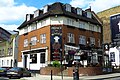
The road is named after Sir John Scott Lillie (1790-1868), who first laid out the easternmost section of the road across his North End Hermitage estate in 1826 running from Gunter's footbridge over the tidal Counter's Creek to the T junction of the old Crown Lane with North End Lane. [2] The intention was to link traffic from the new Hammersmith Bridge with the North End wharves of the planned Kensington Canal, thus obviating passage through Hammersmith and Kensington, or following the entire loop of the River Thames to Chelsea. [3] Lillie's development also included late Georgian housing, terraces called, 'Rosa Villas' and 'Hermitage Cottages', on the north side of his 'New' road, some of which remain and recall Hermitage House that once stood here. He also built a brewery on the opposite side of the road in 1832. Only its 1835 public house, 'The Lillie Arms' remains, renamed the Lillie Langtry, due to the surmise that the Jersey actress had her assignations with the future Edward VII in one of the Georgian houses in Lillie Road. The Lillie Langtry is one of the oldest extant pubs in Fulham, while the 1883 Prince of Wales, opposite, rebuilt by Watney Combe & Reid in the Arts and Crafts style in 1938, is destined for imminent demolition, unlike the former Fuller's Seven Stars, West Kensington, around the North End Road corner, also from 1938, which has been preserved as flats. [4]

Remaining arch of the 1826 Kensington Canal bridge Lillie Canal Bridge.jpg
Remaining arch of the 1826 Kensington Canal bridge

Lillie Road is historically associated with the eponymous bridge over the West London Line, the Lillie Bridge Grounds, a popular 19th-century sports destination, with the Lillie Bridge Depot, the London Underground maintenance workshops, the Sir John Lillie Primary School and, at its western extremity, with the Lillie Road Recreational Grounds, where Sunday league football has been played for generations. Lillie Road was formerly the address of Beaufort School which commemorated Beaufort House and the South Middlesex Rifle Volunteers. [5] There are a number of statutorily and locally listed buildings in Lillie Road. [6]

A little known resident of 62 Lillie Road was the specialised builder and decorator Joseph Bickley (1835-1923). [7] He ran his business from Seagrave Road nearby and patented a plaster formula which became the mainstay of indoor tennis and Real tennis courts throughout Britain and in the United States (such as that at the Tuxedo Club). Its main virtue was to withstand condensation and damp. [8] His courts, and courts he was consulted about, survive to this day, at Petworth House, Jesmond Dene House, Moreton Morrell, Queen's Club and at Hampton Court Palace. He faced bankruptcy proceedings in 1913 when he was in his late 70s. [9] Described as the 'Stradivarius' of the indoor court, he took his secrets with him to the grave. [10]

Commerce

Much of Lillie Road - with the exception of the blighted eastern end - retains some of Fulham's old character and individuality through the presence of small shops and businesses, that include upholstering and picture framing, a famous toy shop, along with a collection of antique shops by Fulham Cross.

Transport

Railways

West Brompton station is at the eastern commencement of Lillie Road serving the London Underground's District line as well as London Overground services. This station also serves Southern services, running between East Croydon, and Watford Junction.

Buses

Bus routes 28, 74, 190, 211, 295, 424 and 430 run along the road, with the 74 and 430 traversing the entire length of the road. The 190 begins its journey to Rochmond at the Empire State Building, which is on the road, with the 211, 295 and 424 only running part of the route (from the A3219 Munster Road to the A219 Fulham Palace Road).

Places of interest

1826 steps to Kensington Canal basin, Fulham Gunter's Lillie Bridge, 1826.jpg
1826 steps to Kensington Canal basin, Fulham

Related Research Articles

<span class="mw-page-title-main">London Borough of Hammersmith and Fulham</span> London borough in United Kingdom

The London Borough of Hammersmith and Fulham is a London borough in West London and which also forms part of Inner London. The borough was formed in 1965 from the merger of the former Metropolitan Boroughs of Hammersmith and Fulham. The borough borders Brent to the north, the Royal Borough of Kensington and Chelsea to the east, Wandsworth to the south, Richmond upon Thames to the south west, and Hounslow and Ealing to the west.

<span class="mw-page-title-main">Fulham</span> Area of west London, England

Fulham is an area of the London Borough of Hammersmith & Fulham in West London, England, 3.6 miles (5.8 km) southwest of Charing Cross. It lies on the north bank of the River Thames, bordering Hammersmith, Kensington and Chelsea. The area faces Wandsworth, Putney, Barn Elms and the London Wetland Centre in Barnes. on the far side of the river.

Earl's Court is a district of Kensington in the Royal Borough of Kensington and Chelsea in West London, bordering the rail tracks of the West London line and District line that separate it from the ancient borough of Fulham to the west, the sub-districts of South Kensington to the east, Chelsea to the south and Kensington to the northeast. It lent its name to the now defunct eponymous pleasure grounds opened in 1887 followed by the pre–World War II Earls Court Exhibition Centre, as one of the country's largest indoor arenas and a popular concert venue, until its closure in 2014.

Sands End is an area of the ancient parish of Fulham, formerly in the County of Middlesex, which is now the southernmost part of the London Borough of Hammersmith and Fulham, England. In a deep loop of the River Thames, between the tidal Chelsea Creek and the old Peterborough estate, west of Wandsworth Bridge, its northern edge is New King's Road. While wharves, industrial acres and workers' cottages gave way to intensive re-development such as Chelsea Harbour and Imperial Wharf in the last quarter of the 20th-century, it still contains some 300-year-old cottages and 19th century streets.

<span class="mw-page-title-main">West Brompton station</span> London Underground and railway station

West Brompton is a London Underground, London Overground and National Rail station on Old Brompton Road (A3218) in West Brompton, located in west London, and is on the District line and West London Line (WLL). It is immediately south of the demolished Earls Court Exhibition Centre and west of Brompton Cemetery in the Royal Borough of Kensington and Chelsea.

<span class="mw-page-title-main">Lillie Bridge Grounds</span> Football stadium

The Lillie Bridge Grounds was a sports ground on the Fulham side of West Brompton, London. It opened in 1866, coinciding with the opening of West Brompton station. It was named after the local landowner, Sir John Scott Lillie (1790–1868) and the Lillie bridge over the West London Line, that links Old Brompton Road with Lillie Road. The grounds were adjacent to the railway on the south side of Lillie Road. Although geographically near to present day Stamford Bridge, there was never direct access, there being the 13 acre now defunct Western Hospital site between the two. The ground was the scene in its day of many sports including athletics, boxing, cricket, cycling and football, and hosted the FA Cup Final in 1873. It closed in 1888 following a riot reported in The Times.

<span class="mw-page-title-main">Parks and open spaces in the London Borough of Hammersmith and Fulham</span>

The London Borough of Hammersmith & Fulham, an Inner London borough, has 231 hectares of parks and open spaces that are accessible to the general public, 159 hectares being within parks and 52.5 hectares within cemeteries and churchyards. Wormwood Scrubs and Scrubs Wood, located in the north of the Borough account for 42 hectares and Fulham Palace and Bishop's Park grounds contain another 14 hectares of open space. Private open space includes Hurlingham, Fulham and Queen's Club in West Kensington.

West Kensington, formerly North End, is an area in the ancient parish of Fulham, in the London Borough of Hammersmith and Fulham, England, 3.4 miles (5.5 km) west of Charing Cross. It covers most of the London postal area of W14, including the area around Barons Court tube station, and is defined as the area between Lillie Road and Hammersmith Road to the west, Fulham Palace Road to the south, Hammersmith to the north and West Brompton and Earl's Court to the east. The area is bisected by the major London artery the A4, locally known as the Talgarth Road. Its main local thoroughfare is the North End Road.

<span class="mw-page-title-main">Fulham Road</span> Street in London, England

Fulham Road is a street in London, England, which comprises the A304 and part of the A308.

Brompton, sometimes called Old Brompton, survives in name as a ward in the Royal Borough of Kensington and Chelsea in London. Until the latter half of the 19th century it was a scattered village made up mostly of market gardens in the county of Middlesex. It lay south-east of the village of Kensington, abutting the parish of St Margaret's, Westminster at the hamlet of Knightsbridge to the north-east, with Little Chelsea to the south. It was bisected by the Fulham Turnpike, the main road westward out of London to the ancient parish of Fulham and on to Putney and Surrey. It saw its first parish church, Holy Trinity Brompton, only in 1829. Today the village has been comprehensively eclipsed by segmentation due principally to railway development culminating in London Underground lines, and its imposition of station names, including Knightsbridge, South Kensington and Gloucester Road as the names of stops during accelerated urbanisation, but lacking any cogent reference to local history and usage or distinctions from neighbouring settlements.

<span class="mw-page-title-main">West Brompton</span> Human settlement in England

West Brompton is an area of west London, England, that straddles the boundary between the London Borough of Hammersmith and Fulham and Royal Borough of Kensington and Chelsea. The centuries-old boundary was traced by Counter's Creek, now lost beneath the West London Line railway.

<span class="mw-page-title-main">Walham Green</span> Area located on the border of Fulham and Chelsea, south-west London

Walham Green is the historic name of an English village, now part of inner London, in the parish of Fulham in the County of Middlesex. It was located between the hamlet of North End to the north, and Parsons Green to the south. To the east it was bounded by Counter's Creek, the historical boundary with the parish of Chelsea, and to the south-east is Sands End.

The West London Railway was conceived to link the London and Birmingham Railway and the Great Western Railway with the Kensington Basin of the Kensington Canal, enabling access to and from London docks for the carriage of goods. It opened in 1844 but was not commercially successful.

<span class="mw-page-title-main">Great Northern, Piccadilly and Brompton Railway</span> Underground railway company in London

The Great Northern, Piccadilly and Brompton Railway (GNP&BR), also known as the Piccadilly tube, was a railway company established in 1902 that constructed a deep-level underground "tube" railway in London, England. The GNP&BR was formed through a merger of two older companies, the Brompton and Piccadilly Circus Railway (B&PCR) and the Great Northern and Strand Railway (GN&SR). It also incorporated part of a tube route planned by a third company, the District Railway (DR). The combined company was a subsidiary of the Underground Electric Railways Company of London (UERL).

<span class="mw-page-title-main">Fulham High Street</span>

Fulham High Street is a street in Fulham, London.

<span class="mw-page-title-main">John Scott Lillie</span> British Army officer

Sir John Scott Lillie was a decorated officer of the British Army and Portuguese Army who fought in the Peninsular War (1808–1814). He was a landowner, entrepreneur and inventor. He was Deputy Lieutenant of the County of Middlesex and Chairman of the Middlesex Quarter Sessions, a freemason, a radical politician and supporter of the great Irish statesman Daniel O'Connell. He was an early antivivisectionist and writer.

<span class="mw-page-title-main">North End Road, Fulham</span>

North End Road is an ancient thoroughfare linking the former hamlet of North End, renamed "West Kensington", with the former village of Walham Green, renamed "Fulham Broadway" in Fulham in London.

<span class="mw-page-title-main">Lillie Bridge (Fulham)</span> Bridge in England

Lillie Bridge is a road bridge that links Old Brompton Road in the Royal Borough of Kensington and Chelsea with Lillie Road in the London Borough of Hammersmith & Fulham. It crosses two railways: the West London Line on the London Overground and the Wimbledon branch of the London Underground at West Brompton station.

<span class="mw-page-title-main">Lillie Bridge Depot</span>

Lillie Bridge Depot is a historic English traction maintenance depot on the London Underground Piccadilly and District lines, situated between West Brompton and West Kensington stations in the London Borough of Hammersmith and Fulham. It is accessed from the District line tracks between Earl's Court and West Kensington or between Earl's Court and Kensington (Olympia).

<span class="mw-page-title-main">North End, Fulham</span> Former village in Middlesex, England

North End was, until the last quarter of the 19th-century, a scattered hamlet among the fields and market gardens, between Counter's Creek and Walham Green in the Parish of Fulham in the County of Middlesex.

References

  1. "Fulham: Walham Green and North End". British History Online . Retrieved 20 October 2016.
  2. Report of the Committee of Magistrates appointed (26th October 1820) to make enquiry respecting the Public Bridges in the County of Middlesex. London: printed by J. Rider, Little Britain, 1826. See page 187 for Counter's Creek (Sewer). https://books.google.com/books?id=jaFfAAAAcAAJ&q=James+Gunter%27s+footbridge accessed 2016-10-12
  3. Féret, Charles (1900). Fulham Old and New, vol.I-III (PDF). Vol. III. Leadenhall Press.
  4. Denny, Barbara (1997). Fulham Past. London: Historical Publications. p. 49. ISBN   0-948667-43-5.
  5. Denny, Barbara (1997). Fulham Past. London: Historical Publications. pp. 48–50. ISBN   0-948667-43-5.
  6. Hammersmith and Fulham Historic Buildings Group, Local List. Ed. Angela Dixon, Fourth Edition revised September 2004, pages 72-74.
  7. Dictionary of Scottish Architects http://www.scottisharchitects.org.uk/architect_full.php?id=204796 Note: The death date listed for Joseph Bickley in the dictionary is contradicted by the two following sources.
  8. Millar, William (2016). Plastering: Plain and Decorative. London: Routledge. p. 83. ISBN   978-1-873394-30-4.
  9. https://www.thegazette.co.uk/London/issue/28873/page/6556/data.pdf [accessed 24 October 2016]
  10. Last Hammersmith and Fulham entry in https://content.historicengland.org.uk/images-books/publications/played-in-london-directory-sporting-assets-london/DirectoryofHistoricSportingAssetsinLondon.pdf/ [accessed 24 October 2016]

51°29′15″N0°11′44″W / 51.48752°N 0.19558°W / 51.48752; -0.19558