The Funeral Mountains are a short, arid mountain range in the United States along the California-Nevada border approximately 100 mi (160 km) west of Las Vegas. The mountains are considered a subrange of the Amargosa Range that form the eastern wall of Death Valley.

The Nightingale Mountains are a north–south trending range located along the western border of Pershing County and extending into the northeastern corner of Washoe County. The range has a length of 32.2 km (20.0 mi) and a width of about 5.5 km (3.4 mi). The highest peak has an elevation of 2,511 m (8,238 ft) which is 1,353 m (4,439 ft) above the elevation of the dry Winnemucca Lake bed at about 1,158 m (3,799 ft).
The Shoshone Mountains, in west central Nevada, make up one of the longest mountain ranges in the state. The range runs in a general north-south direction in Nye and Lander counties. The range has a length of about 66 miles (106 km) and a width of about 6 mi (9.7 km) with an area of approximately 400 sq mi (1,000 km2).

The New York Mountains are a small mountain range found in northeastern San Bernardino County in California, USA. The range's northeastern area lies in southeastern Nevada. The range lies just south of the small community of Ivanpah, and north of the Lanfair Valley. The mountains are part of the mountain ranges, cones, mountains, and landforms in the Mojave National Preserve. The mountains reach an elevation of 7,533 feet (2,296 m), and run in a mostly southwest-northeasterly direction between the Providence Mountains and the McCullough Range approximately five miles into Nevada and border the northwest corner of the Piute Valley of Nevada-California.
The Simpson Park Mountains, also known as the Simpson Park Range, are located in Lander and Eureka counties, in central Nevada in the western United States. The mountains reach an elevation of 9,147 feet (2,788 m) at Fagin Mountain, and cover an area of approximately 310 square miles (800 km2). US Route 50 crosses the very southern end of the range at Hickison Summit between Eureka and Austin.

The Pancake Range is located in east-central Nevada in the United States. The range extends as an irregular sinuous line for approximately 90 miles (140 km) with a roughly north-south trend in Nye and White Pine counties. The range reaches an elevation of 9,240 feet (2,820 m) at Portuguese Mountain. Neighboring ranges include the White Pine, Grant and Quinn Canyon ranges across Railroad Valley on the east-southeast; and Park and Hot Creek ranges across Big Sandy Springs and Hot Creek valleys on the west-northwest. The south end of Newark Valley lies at the extreme north end of the range. The Lunar Crater Volcanic Field lies at the southwestern end of the chain with the Reveille Range to the south.
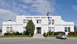
The Tule Desert is located in southeastern Nevada in Lincoln County, near the Utah state line. The desert lies northeast of the Mormon Mountains, south of the Clover Mountains and west of the Tule Springs Hills.

The Meadow Valley Mountains is a mountain range in Lincoln and Clark counties in southern Nevada. The range is a narrow north to northeast trending ridgeline with a length of about 40 miles (64 km). The Clover Mountains lie to the north, Meadow Valley Wash and the Mormon Mountains to the east, the Moapa Valley to the southeast, Arrow Canyon Range to the south, Coyote Springs Valley to the southwest and the Kane Springs Valley and Delamar Mountains to the west and northwest.
The White Rock Mountains are a north-northwest trending mountain range located in eastern Lincoln County, Nevada with the eastern slopes of the range extending into Beaver and Iron counties of Utah. The north end of the range merges with the Wilson Creek Range on the west.
The Fortification Range is a mountain range in Lincoln and White Pine counties, Nevada. The range is a narrow linear range trending north-northwest with a length of 34 km (21 mi) and a width of about 8 km (5.0 mi). It is typical of the Basin and Range Province.
The Golden Gate Range is a mountain range in northwest Lincoln, and eastern Nye counties Nevada. The range trends north-northeast between the Garden Valley to the west and the Coal Valley to the east. The southern end of the range in Lincoln County contains the highest peaks whereas the northern portion exists as a broken string of lower hills separated by water gaps. The northeast end of the range is bounded by the White River Valley to the east. The Worthington Mountains, the Quinn Canyon Range and the Grant Range lie to the west and northwest with the Seaman Range to the east and Timpahute Range and Mount Irish Range to the south.
The Gap Mountains are a mountain range in eastern Nye County, Nevada. Gap Mountain along with Fox Mountain 7.5 miles (12.1 km) to the south and the hills between overlook the White River valley to the west. Gap Mountain lies just 1.5 mi (2.4 km) southwest of the southern end of the Egan Range of adjacent Lincoln County and appears to be an extension of that range. Fox Mountain lies about 5 miles west of the south end of the Schell Creek Range and 7 mi (11 km) northeast of the north end of the Seaman Range.The Grant Range and small Golden Gate Range lie to the west across the White River Valley.
The Tule Springs Hills are a mountain range in eastern Lincoln County, Nevada. The Tule Desert lies to the west. The Mormon Mountains and East Mormon Mountains are to the southwest, the Clover Mountains to the north and the Beaver Dam Mountains of Utah are to the east.

The Cerro Colorado Mountains are a low mountain range in southern Pima County, Arizona, USA. The highest point of the range is. The range consists of a NNW–SSE trending ridge with several shorter ridges extending off the main ridge to the ENE. The higher portions of the range cover an area of about 21 km2 (8.1 sq mi), with dimensions of 6.8 km (4.2 mi) by 4.0 km (2.5 mi).

The Little Snowy Mountains are a small mountain range in central Montana about 25 miles (40 km) southeast of Lewistown. The range lies mostly in Fergus County, but the southern part of the range extends into Golden Valley and Musselshell counties.
The San Luis Mountains are a small, lower elevation mountain range of central-southern Pima County Arizona adjacent to the U.S.-Mexico border, northeast of Sasabe, Arizona–Sasabe, Sonora.
The West Silver Bell Mountains are a small 10 mile (16 km) long mountain range of south-central Arizona, United States. The range lies in the north-central arid Sonoran Desert; the Madrean Sky Islands region of southeast Arizona, around Tucson is adjacent to the southeast.
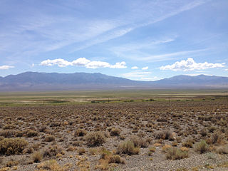
The Antelope Valley of southern Eureka County is a small 35 mi long valley, surrounded by four mountain ranges. Antelope Wash flows north, to endorheic flatlands at the valley's north end. Eureka, Nevada lies 20 mi east nestled among mountain ranges. From Eureka U.S. Route 50 travels west through the north end of the valley on a route to Austin.

Newark Valley is a north–south trending endorheic valley in western White Pine County, Nevada. The valley contains the dry Newark Lake bed which is approximately 23 km (14 mi) by 3.5 km (2.2 mi). To the west the Diamond Mountains border the valley and to the east various minor mountains separate the Newark from Long Valley. To the north across a relatively low divide lies Huntington and Ruby valleys.
The Battle Mountains or Battle Mountain Range is a mountain range in western Lander and southeastern Humboldt counties of Nevada. The communities of Battle Mountain and Valmy lie just to the east and north respectively along Interstate 80 in the Humboldt River valley. Nevada State Route 305 runs along the southeast side of the range from Battle Mountain toward Austin to the south.