
The Humboldt–Toiyabe National Forest (HTNF) is the principal U.S. National Forest in the U.S. state of Nevada, and has a smaller portion in Eastern California. With an area of 6,289,821 acres (25,454.00 km2), it is the largest U.S. National Forest outside Alaska.

The Black Rock Desert is a semi-arid region of lava beds and playa, or alkali flats, situated in the Black Rock Desert–High Rock Canyon Emigrant Trails National Conservation Area, a silt playa 100 miles (160 km) north of Reno, Nevada that encompasses more than 300,000 acres (120,000 ha) of land and contains more than 120 miles (200 km) of historic trails. It is in the northern Nevada section of the Great Basin with a lakebed that is a dry remnant of Pleistocene Lake Lahontan.

The Humboldt River is an extensive river drainage system located in north-central Nevada. It extends in a general east-to-west direction from its headwaters in the Jarbidge, Independence, and Ruby Mountains in Elko County, to its terminus in the Humboldt Sink, approximately 225 miles away in northwest Churchill County. Most estimates put the Humboldt River at 290 miles (470 km) long however, due to the extensive meandering nature of the river, its length is more closely estimated at 380 miles (612 km). It is located within the Great Basin Watershed and is the third longest river in the watershed behind the Bear River at 355 miles (570 km) and the Sevier River at 325 miles (523 km). The Humboldt River Basin is the largest sub-basin of the Great Basin encompassing an area of 16,840 square miles (43,615 km2). It is the only major river system wholly contained within the state of Nevada.
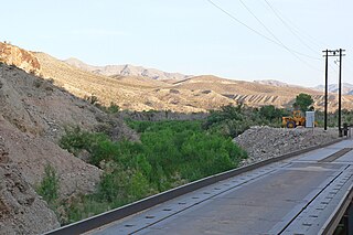
The Meadow Valley Wash is a southern Nevada stream draining the Meadow Watershed that is bordered on three sides by the Great Basin Divide. The wash's Lincoln County headpoint is in the Wilson Creek Range, and the wash includes two upper confluences. Panaca is along the upper wash, and downstream of Caliente is the wash's confluence with its east fork. Just prior to the junction with the Muddy River, the wash flows from Lincoln County into northeastern Clark County. It flows into the Muddy in the Moapa Valley just west of Glendale adjacent to Interstate 15 approximately 40 miles (64 km) northwest of Las Vegas.

The Walker River is a river in west-central Nevada in the United States, approximately 62 miles (100 km) long. Fed principally by snowmelt from the Sierra Nevada mountains of California, it drains an arid portion of the Great Basin southeast of Reno and flows into the endorheic basin of Walker Lake. The river is an important source of water for irrigation in its course through Nevada; water diversions have reduced its flow such that the level of Walker Lake has fallen 160 feet (49 m) between 1882 and 2010. The river was named for explorer Joseph Reddeford Walker.

Ursine is an unincorporated community and census-designated place in Lincoln County, Nevada, United States. It is located in the foothills of the White Rock Mountains on Eagle Valley about two miles downstream from the Eagle Valley Reservoir and Spring Valley State Park. The population was 91 at the 2010 census.
The Hot Creek Range is a volcanic mountain range in Nye County, in central Nevada in the western United States. From the historic community of Warm Springs, the range runs north-northeast for approximately 43 miles (69 km).

Mount Wilson is a mountain located in the Spring Mountain range of southern Nevada. It is located on land managed by the United States Bureau of Land Management as the Red Rock Canyon National Conservation Area, part of the Rainbow Mountain Wilderness Area. It is the highest peak in the Red Rock Canyon National Conservation Area.

The Jackson Mountains are a north-northeast trending mountain range in southwestern Humboldt County, Nevada. The range is flanked on the west by the Black Rock Desert and the Black Rock Range beyond. To the north across the Quinn River and Nevada State Route 140 lie the Bilk Creek Mountains. To the northeast across Kings River Valley is the Double Mountains and to the east are the Sleeping Hills. To the southeast and south lie the Eugene and Kamma Mountains. The ghost town of Sulphur lies just southwest of the pass between the Jackson and Kamma ranges. Nevada State Route 49 and the Union Pacific railroad Feather River Route traverse this pass.
The White Rock Mountains are a north-northwest trending mountain range located in eastern Lincoln County, Nevada with the eastern slopes of the range extending into Beaver and Iron counties of Utah. The north end of the range merges with the Wilson Creek Range on the west.
The Fortification Range is a mountain range in Lincoln and White Pine counties, Nevada. The range is a narrow linear range trending north-northwest with a length of 34 km (21 mi) and a width of about 8 km (5.0 mi). It is typical of the Basin and Range Province.
The Gap Mountains are a mountain range in eastern Nye County, Nevada. Gap Mountain along with Fox Mountain 7.5 miles (12.1 km) to the south and the hills between overlook the White River valley to the west. Gap Mountain lies just 1.5 mi (2.4 km) southwest of the southern end of the Egan Range of adjacent Lincoln County and appears to be an extension of that range. Fox Mountain lies about 5 miles west of the south end of the Schell Creek Range and 7 mi (11 km) northeast of the north end of the Seaman Range.The Grant Range and small Golden Gate Range lie to the west across the White River Valley.
The Limestone Hills are a group of hills in northeast Lincoln County, Nevada. The hills trend northwest–southeast with a length of about 27 km (17 mi) and width of about 3.5 km (2.2 mi). They lie adjacent to the north end of the Wilson Creek–White Rock ranges and the old mining camp of Atlanta. The Nevada–Utah border is 16.5 km (10.3 mi) across Hamlin Valley to the east. The Snake Range and White Pine County lie 12 km (7.5 mi) to the north. The Fortification Range lies to the northwest.

The Trout Creek Mountains are a remote, semi-arid Great Basin mountain range mostly in southeastern Oregon and partially in northern Nevada in the United States. The range's highest point is Orevada View Benchmark, 8,506 feet (2,593 m) above sea level, in Nevada. Disaster Peak, elevation 7,781 feet (2,372 m), is another prominent summit in the Nevada portion of the mountains.
Parsnip Peak Wilderness is a 43,693-acre (17,682 ha) wilderness in northeastern Lincoln County, Nevada. Its elevations range from 6,160 to 8,916 feet. It received wilderness status in 2004.
The Antelope Valley of west Lander County is a small, 25 mile long, mostly arid valley in central Nevada, USA. A fourth valley of the same name Antelope Valley lies in southern Eureka County, east of the Monitor Range. The Lander County valley lies south of the Humboldt River and with Antelope Creek, is a western tributary valley to the north-flowing Reese River.
Potts is a ghost town and abandoned ranching property in Monitor Valley, Nye County, Nevada, approximately 2 miles east of Nevada State Route 82.

The Deep Creek murders was the culmination of a minor sheep war in the borderlands of Idaho and Nevada. On or about February 4, 1896, two Mormon sheepherders were killed by an unknown assailant while they were camping along a creek in what was then part of Cassia County, Idaho. The gunfighter Diamondfield Jack Davis and his associate, Jack Gleason, were arrested, but the latter was released and Diamondfield Jack was pardoned in 1902, after serving six years in jail. The deaths of the two sheepherders are the only confirmed killings attributed to the conflict, however, according to author J. Anthony Lukas, the incident was "one of the last great confrontations in the sheep and cattle wars."
Mount Wilson is a census-designated place in Lincoln County, Nevada, United States. As of the 2010 census it had a population of 33.
