
Lincoln Airport is a public/military airport five miles (8.0 km) northwest of downtown Lincoln, the state capital, in Lancaster County, Nebraska, United States. It is owned by the Lincoln Airport Authority and is the second-largest airport in Nebraska. It is included in the Federal Aviation Administration (FAA) National Plan of Integrated Airport Systems for 2023–2027 in which it is categorized as a non-hub primary commercial service facility. It has four gates with jetways, to be, as of February 2022, expanded to six.
Taunton Municipal Airport, also known as King Field, is a public use airport located three nautical miles (6 km) east of the central business district of Taunton, a city in Bristol County, Massachusetts. It is located in the East Taunton neighborhood of the city. The city-owned airport is maintained and operated by the Taunton Airport Commission. According to the FAA's National Plan of Integrated Airport Systems for 2009–2013, it is categorized as a general aviation airport.
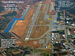
Kenai Municipal Airport is a city-owned, public-use airport located in Kenai, a city in the Kenai Peninsula Borough of the U.S. state of Alaska.
Talladega Municipal Airport is a city-owned public-use airport located eight nautical miles northeast of the central business district of Talladega, a city in Talladega County, Alabama, adjacent to Talladega Superspeedway in the city of Lincoln. It is included in the FAA's National Plan of Integrated Airport Systems for 2011–2015, which categorized it as a general aviation facility.

Newport Municipal Airport is a city-owned, public-use airport located three nautical miles (6 km) south of the central business district of Newport, a city in Lincoln County, Oregon, United States. It is included in the National Plan of Integrated Airport Systems for 2011–2015, which categorized it as a general aviation facility.

Vernonia Municipal Airport is a city-owned, public-use airport located two nautical miles west of the central business district of Vernonia, a city in Columbia County, Oregon, United States.
Unionville Municipal Airport is a city-owned, public-use airport located three nautical miles (6 km) north of the central business district of Unionville, a city in Putnam County, Missouri, United States. It was previously known as Municipal Airport and was also known as Unionville Airport.

Atmore Municipal Airport is a city-owned public-use airport located 3 nautical miles (6 km) east of the central business district of Atmore, a city in Escambia County, Alabama, United States. According to the FAA's National Plan of Integrated Airport Systems for 2009–2013, it is categorized as a general aviation facility.

Florala Municipal Airport is a city-owned public-use airport located three nautical miles northeast of the central business district of Florala, a city in Covington County, Alabama, United States.

Foley Municipal Airport is a city-owned public-use airport located three nautical miles northwest of the central business district of Foley, a city in Baldwin County, Alabama, United States.
Greensboro Municipal Airport is a city-owned public-use airport located three nautical miles southwest of the central business district of Greensboro, a city in Hale County, Alabama, United States.

Grove Hill Municipal Airport was a city-owned public-use airport located two nautical miles southeast of the central business district of Grove Hill, a city in Clarke County, Alabama, United States. According to the FAA's National Plan of Integrated Airport Systems for 2009–2013, it was categorized as a general aviation facility. The airport has been permanently closed.

Headland Municipal Airport is a city-owned, public-use airport located two nautical miles northeast of the central business district of Headland, a city in Henry County, Alabama, United States.
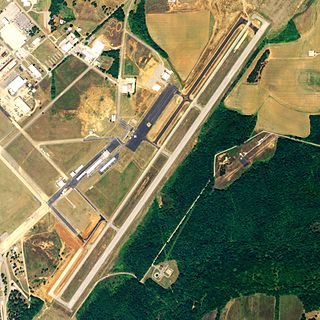
Fort Worth Spinks Airport is a city-owned, public-use airport located 14 nautical miles (26 km) south of the central business district of Fort Worth, in Tarrant County, Texas, United States. It is the newest of the three airports that are owned by the City of Fort Worth and it serves the cities of Fort Worth, Burleson, and Mansfield. The airport is located at the intersection of Interstate 35W and HWY 1187 and serves as a reliever airport for Fort Worth Meacham International Airport and Dallas–Fort Worth International Airport and has Class D designation.
Lee's Summit Municipal Airport is a public use airport in Jackson County, Missouri, United States. It is owned by the City of Lee's Summit and is located three nautical miles (6 km) north of its central business district. This facility is included in the National Plan of Integrated Airport Systems, which categorized it as a general aviation reliever airport.
Albany Municipal Airport is a city-owned public-use airport located one nautical mile north of the central business district of Albany, a city in Gentry County, Missouri, United States.
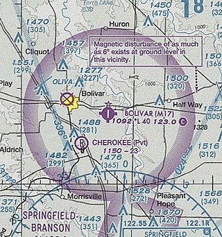
Bolivar Municipal Airport is a city-owned public-use airport located four nautical miles east of the central business district of Bolivar, a city in Polk County, Missouri, United States. It is included in the FAA's National Plan of Integrated Airport Systems for 2011–2015, which categorized it as a general aviation facility.
Fayetteville Municipal Airport is a public use airport located six nautical miles south of the central business district of Fayetteville, a city in Lincoln County, Tennessee, United States, in the community of Park City. It is owned by the Fayetteville-Lincoln Airport Authority. It is included in the National Plan of Integrated Airport Systems for 2011–2015, which categorized it as a general aviation airport.
Davenport Airport, also known as Davenport Municipal Airport, is a city-owned, public-use airport located one nautical mile (2 km) west of the central business district of Davenport, a city in Lincoln County, Washington, United States. It is included in the National Plan of Integrated Airport Systems for 2011–2015, which categorized it as a general aviation facility.
Lincoln Municipal Airport is a public use airport in Lincoln County, Kansas, United States. It is owned by the City of Lincoln, also known as Lincoln Center, and located two nautical miles (4 km) northwest of the central business district.

