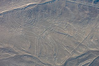
The Nazca lines are a group of over 700 geoglyphs made in the soil of the Nazca Desert in southern Peru. They were created between 500 BC and 500 AD by people making depressions or shallow incisions in the desert floor, removing pebbles and leaving different-colored dirt exposed. There are two major phases of the Nazca lines, Paracas phase, from 400 to 200 BC, and Nazca phase, from 200 BC to 500 AD. In the 21st century, several hundred new figures had been found with the use of drones, and archaeologists believe that there are more to be found.

Nazca is a city and system of valleys on the southern coast of Peru. The city of Nazca is the largest in the Nazca Province. The name is derived from the Nazca culture, which flourished in the area between 100 BC and AD 800. This culture was responsible for the Nazca Lines and the ceremonial city of Cahuachi. They also constructed additional underground aqueducts, named puquios, in a regional system that still functions today. The first puquios are believed to have been built by the preceding Paracas culture.
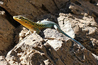
Liolaemus is a genus of iguanian lizards, containing many species, all of which are endemic to South America.
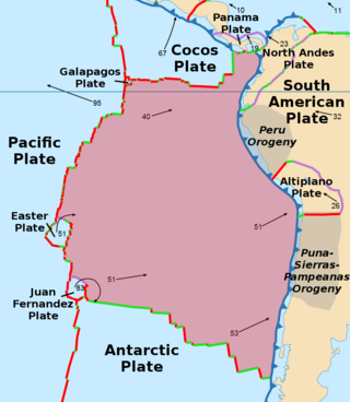
The Nazca plate or Nasca plate, named after the Nazca region of southern Peru, is an oceanic tectonic plate in the eastern Pacific Ocean basin off the west coast of South America. The ongoing subduction, along the Peru–Chile Trench, of the Nazca plate under the South American plate is largely responsible for the Andean orogeny. The Nazca plate is bounded on the west by the Pacific plate and to the south by the Antarctic plate through the East Pacific Rise and the Chile Rise, respectively. The movement of the Nazca plate over several hotspots has created some volcanic islands as well as east–west running seamount chains that subduct under South America. Nazca is a relatively young plate in terms of the age of its rocks and its existence as an independent plate, having been formed from the breakup of the Farallon plate about 23 million years ago. The oldest rocks of the plate are about 50 million years old.

The Cocos plate is a young oceanic tectonic plate beneath the Pacific Ocean off the west coast of Central America, named for Cocos Island, which rides upon it. The Cocos plate was created approximately 23 million years ago when the Farallon plate broke into two pieces, which also created the Nazca plate. The Cocos plate also broke into two pieces, creating the small Rivera plate. The Cocos plate is bounded to the northeast by the North American plate and the Caribbean plate. To the west it is bounded by the Pacific plate and to the south by the Nazca plate.

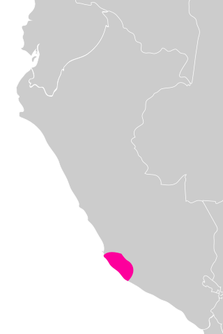
Ica is a department and region of Peru. It borders the Pacific Ocean on the west; the Lima Region on the north; the Huancavelica and Ayacucho regions on the east; and the Arequipa Region on the south. Its capital is the city of Ica.
The Nazca culture was the archaeological culture that flourished from c. 100 BC to 800 AD beside the arid, southern coast of Peru in the river valleys of the Rio Grande de Nazca drainage and the Ica Valley. Strongly influenced by the preceding Paracas culture, which was known for extremely complex textiles, the Nazca produced an array of crafts and technologies such as ceramics, textiles, and geoglyphs.
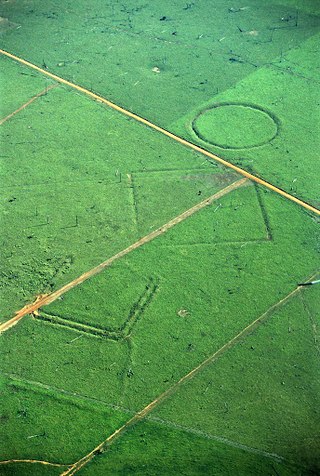
A geoglyph is a large design or motif – generally longer than 4 metres (13 ft) – produced on the ground by durable elements of the landscape, such as stones, stone fragments, gravel, or earth. A positive geoglyph is formed by the arrangement and alignment of materials on the ground in a manner akin to petroforms, while a negative geoglyph is formed by removing part of the natural ground surface to create differently coloured or textured ground in a manner akin to petroglyphs.

The Nazca booby is a large seabird of the booby family, Sulidae, native to the eastern Pacific. First described by Walter Rothschild in 1902, it was long considered a subspecies of the masked booby until recognised as distinct genetically and behaviorally in 2002. It has a typical sulid body shape, with a long pointed orange-yellow bill, long neck, aerodynamic body, long slender wings and pointed tail. The adult is bright white with black and white wings, a black tail and a dark face mask.

The Galápagos microplate (GMP) is a geological feature of the oceanic crust located at 1°50' N, offshore of the west coast of Colombia. The GMP is collocated with the Galápagos triple junction (GTJ), which is an atypical ridge–ridge–ridge triple junction. At the GTJ, the Pacific plate, Cocos plate, and Nazca plate meet incompletely, forming two counter-rotating microplates at the junction of the Cocos–Nazca, Pacific–Cocos, and Pacific–Nazca spreading ridges.

The Nazca Province is one of five provinces of the Ica Region of Peru. The capital of the province is the city of Nazca.

The Chilean Matorral (NT1201) is a terrestrial ecoregion of central Chile, located on the west coast of South America. It is in the Mediterranean forests, woodlands, and scrub biome, part of the Neotropical realm.

The Juan Fernandez plate is a small tectonic plate (microplate) in the Pacific Ocean. With a surface area of approximately 105 km2, the microplate is located between 32° and 35°S and 109° and 112°W. The plate is located at a triple junction between the Antarctic plate, the Nazca plate, and the Pacific plate. Approximately 2,000 km to the west of South America, it is, on average, 3,000 meters deep with its shallowest point coming to approximately 1,600 meters, and its deepest point reaching 4,400 meters.

The Nazca Ridge is a submarine ridge, located on the Nazca plate off the west coast of South America. This plate and ridge are currently subducting under the South American plate at a convergent boundary known as the Peru-Chile Trench at approximately 7.7 cm (3.0 in) per year. The Nazca Ridge began subducting obliquely to the collision margin at 11°S, approximately 11.2 Ma, and the current subduction location is 15°S. The ridge is composed of abnormally thick basaltic ocean crust, averaging 18 ±3 km thick. This crust is buoyant, resulting in flat slab subduction under Peru. This flat slab subduction has been associated with the uplift of Pisco Basin and the cessation of Andes volcanism and the uplift of the Fitzcarrald Arch on the South American continent approximately 4 Ma.

Chauchilla Cemetery is a cemetery that contains prehispanic mummified human remains and archeological artifacts, located 30 kilometres (19 mi) south of the city of Nazca in Peru.

The Paracas Candelabra, also called the Candelabra of the Andes, or El Candelabro (the Trident), is a well-known prehistoric geoglyph found on the northern face of the Paracas Peninsula at Pisco Bay in Peru. Pottery found nearby has been radio carbon dated to 200 BCE, the time of the Paracas culture. The design is cut two feet (0.61 m) into the soil, with stones possibly from a later date placed around it. The figure is 600 feet (180 meters) tall, large enough to be seen 12 miles (19.3 km) at sea.

The Maria Reiche Neuman Airport is a small airport serving Nazca, in the Ica Region of Peru. The airport is named after Maria Reiche, a principal researcher and proponent of the Nazca Lines.

Roberto Donoso-Barros was a Chilean zoologist, naturalist, and herpetologist. Jaime Péfaur listed his birth year as 1922.

The Chile Ridge, also known as the Chile Rise, is a submarine oceanic ridge formed by the divergent plate boundary between the Nazca plate and the Antarctic plate. It extends from the triple junction of the Nazca, Pacific, and Antarctic plates to the Southern coast of Chile. The Chile Ridge is easy to recognize on the map, as the ridge is divided into several segmented fracture zones which are perpendicular to the ridge segments, showing an orthogonal shape toward the spreading direction. The total length of the ridge segments is about 550–600 km.