Berkeley County
| [2] | Name on the Register | Image | Date listed [3] | Location | City or town | Description |
|---|---|---|---|---|---|---|
| 1 | Mt. Pleasant School | 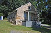 | September 18, 2008 (#08000928) | Abiding Way 39°21′49″N78°07′28″W / 39.363611°N 78.124444°W | Gerrardstown |
This is intended to be a complete list of the African American historic places in West Virginia. The locations and districts for which the latitude and longitude coordinates are included below, may be seen in a Google map. [1]
| Color | Denotes |
|---|---|
| NRHP listing | National Register of Historic Places listing |
| NRHP HD | National Register Historic District |
| Not listed on the NRHP | Not listed on the National Register |
| Berkeley - Cabell - Fayette - Hampshire - Harrison - Jefferson - Kanawha - Lewis - McDowell - Mercer - Monongalia - Pocahontas - Preston - Wood |
| [2] | Name on the Register | Image | Date listed [3] | Location | City or town | Description |
|---|---|---|---|---|---|---|
| 1 | Mt. Pleasant School | | September 18, 2008 (#08000928) | Abiding Way 39°21′49″N78°07′28″W / 39.363611°N 78.124444°W | Gerrardstown |
| [2] | Name on the Register | Image | Date listed [3] | Location | City or town | Description |
|---|---|---|---|---|---|---|
| 1 | Barnett Hospital and Nursing School |  | December 30, 2009 (#09001190) | 1201 7th Ave. 38°25′03″N82°26′15″W / 38.417617°N 82.437514°W | Huntington | |
| 2 | Douglass Junior and Senior High School | 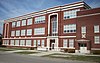 | December 5, 1985 (#85003091) | 10th Ave. and Bruce St. 38°24′52″N82°25′53″W / 38.414444°N 82.431389°W | Huntington | |
| 3 | West Virginia Colored Children's Home |  | November 13, 1997 (#97001413) | 3353 U.S. Route 60 38°24′34″N82°22′25″W / 38.409444°N 82.373611°W | Huntington | Demolished on May 5, 2011 to make room for a new middle school. [4] [5] |
| [2] | Name on the Register | Image | Date listed [3] | Location | City or town | Description |
|---|---|---|---|---|---|---|
| 1 | Camp Washington-Carver Complex |  | June 20, 1980 (#80004017) | County Route 11/3 38°00′36″N80°58′14″W / 38.01°N 80.970556°W | Clifftop |
| [2] | Name on the Register | Image | Date listed [3] | Location | City or town | Description |
|---|---|---|---|---|---|---|
| 1 | Mount Pisgah Benevolence Cemetery |  | Not listed (#unlisted) | Along U.S. Route 50 39°20′30″N78°46′04″W / 39.3417°N 78.7678°W | Romney | |
| 2 | Mount Pisgah United Methodist Church | Not listed (#unlisted) | 239 North High Street (West Virginia Route 28) 39°20′40″N78°45′20″W / 39.3443413°N 78.7554966°W | Romney | ||
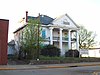
| 3 | Washington Place |  | Not listed (#unlisted) | Along West Virginia Route 28 39°21′14″N78°45′09″W / 39.354003°N 78.752489°W | Romney |
| [2] | Name on the Register | Image | Date listed [3] | Location | City or town | Description |
|---|---|---|---|---|---|---|
| 1 | Kelly Miller High School | Not listed (#unlisted) | E. B. Saunders Way 39°16′36″N80°20′09″W / 39.27675°N 80.33589°W | Clarksburg |
| [2] | Name on the Register | Image | Date listed [3] | Location | City or town | Description |
|---|---|---|---|---|---|---|
| 1 | Halltown Colored Free School |  | August 25, 2004 (#04000912) | Halltown Rd., 0.5 mi (0.80 km) northeast of U.S. Route 340 39°18′44″N77°48′06″W / 39.312222°N 77.801667°W | Halltown | |
| 2 | Halltown Union Colored Sunday School |  | January 12, 1984 (#84003591) | Off U.S. Route 340 39°18′34″N77°48′11″W / 39.309444°N 77.803056°W | Halltown | |
| 3 | Storer College |  | October 15, 1966 (#66000041) | Contributing property to Harpers Ferry National Historical Park NRHP listing 39°19′26″N77°44′07″W / 39.323789°N 77.735414°W | Harpers Ferry |
| [2] | Name on the Register | Image | Date listed [3] | Location | City or town | Description |
|---|---|---|---|---|---|---|
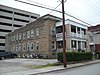
| 1 | Weston Colored School |  | April 9, 1993 (#93000224) | 345 Center St. 39°02′23″N80°27′53″W / 39.039722°N 80.464722°W | Weston |
| [2] | Name on the Register | Image | Date listed [3] | Location | City or town | Description |
|---|---|---|---|---|---|---|
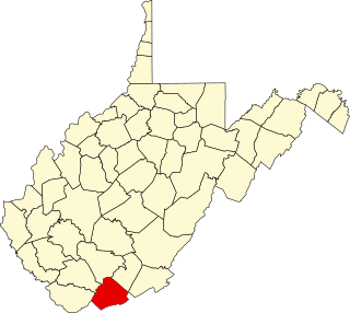
| 1 | World War Memorial |  | April 9, 1993 (#93000227) | U.S. Route 52 37°25′31″N81°30′24″W / 37.425278°N 81.506667°W | Kimball |
| [2] | Name on the Register | Image | Date listed [3] | Location | City or town | Description |
|---|---|---|---|---|---|---|
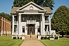
| 1 | Hancock House |  | January 17, 1990 (#89001783) | 300 Sussex St. 37°16′33″N81°13′13″W / 37.275833°N 81.220278°W | Bluefield |
| [2] | Name on the Register | Image | Date listed [3] | Location | City or town | Description |
|---|---|---|---|---|---|---|
| 1 | Second Ward Negro Elementary School |  | July 28, 1992 (#92000896) | Junction of White and Posten Aves. 39°37′17″N79°56′57″W / 39.621389°N 79.949167°W | Morgantown |
| [2] | Name on the Register | Image | Date listed [3] | Location | City or town | Description |
|---|---|---|---|---|---|---|
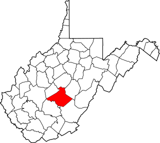
| 1 | Seebert Lane Colored School | December 12, 2012 (#12001053) | Seebert Rd. 38°08′47″N80°11′39″W / 38.146332°N 80.194049°W | Seebert |
| [2] | Name on the Register | Image | Date listed [3] | Location | City or town | Description |
|---|---|---|---|---|---|---|
| 1 | Indian Rocks Dining Hall |  | January 8, 2003 (#02001688) | WV 7, 1 mile east of Reedsville 39°30′37″N79°45′55″W / 39.510278°N 79.765278°W | Reedsville |
| [2] | Name on the Register | Image | Date listed [3] | Location | City or town | Description |
|---|---|---|---|---|---|---|
| 1 | Bethel AME Church |  | October 8, 1998 (#82001767) | 820 Clay St. 39°15′58″N81°33′18″W / 39.266111°N 81.555°W | Parkersburg | Demolished |
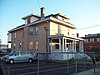
| 2 | Henry Logan Memorial AME Church |  | December 16, 1982 (#82001778) | Ann and 6th Sts. 39°16′05″N81°33′41″W / 39.268056°N 81.561389°W | Parkersburg |
This is a list of the National Register of Historic Places listings in Berkeley County, West Virginia.
This is a list of the National Register of Historic Places listings in Preston County, West Virginia. This is intended to be a complete list of the properties and districts on the National Register of Historic Places in Preston County, West Virginia. The locations of National Register properties and districts for which the latitude and longitude coordinates are included below, may be seen in an online map.

This is a list of the National Register of Historic Places listings in Ohio County, West Virginia.

This is a list of the National Register of Historic Places listings in Greenbrier County, West Virginia.

This is a list of the National Register of Historic Places listings in Monroe County, West Virginia.

This is a list of the National Register of Historic Places listings in Marion County, West Virginia.
This is a list of the National Register of Historic Places listings in Mercer County, West Virginia.
This is a list of the National Register of Historic Places listings in Nicholas County, West Virginia.

This is a list of the National Register of Historic Places listings in Lewis County, West Virginia.

This is a list of the National Register of Historic Places listings in Mineral County, West Virginia.

This is a list of the National Register of Historic Places listings in Wetzel County, West Virginia.

This is a list of the National Register of Historic Places listings in Barbour County, West Virginia.

This is a list of the National Register of Historic Places listings in Marshall County, West Virginia.

This is a list of the National Register of Historic Places listings in Doddridge County, West Virginia.

This is a list of the National Register of Historic Places listings in Upshur County, West Virginia.

This is a list of the National Register of Historic Places listings in Boone County, West Virginia.

This is a list of the National Register of Historic Places listings in Putnam County, West Virginia.

This is a list of the National Register of Historic Places listings in Summers County, West Virginia.

This is a list of the National Register of Historic Places listings in Taylor County, West Virginia.

This is a list of the National Register of Historic Places listings in Tucker County, West Virginia.