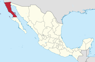
Baja California, officially the Free and Sovereign State of Baja California, is a state in Mexico. It is the northernmost and westernmost of the 32 federal entities of Mexico. Before becoming a state in 1952, the area was known as the North Territory of Baja California. It has an area of 70,113 km2 (27,071 sq mi) and comprises the northern half of the Baja California Peninsula, north of the 28th parallel, plus oceanic Guadalupe Island. The mainland portion of the state is bordered on the west by the Pacific Ocean; on the east by Sonora, the U.S. state of Arizona, and the Gulf of California; on the north by the U.S. state of California; and on the south by Baja California Sur.

Mexicali is the capital city of the Mexican state of Baja California. The city, seat of the Mexicali Municipality, has a population of 689,775, according to the 2010 census, while the Calexico–Mexicali metropolitan area is home to 1,000,000 inhabitants on both sides of the United States-Mexico border. Mexicali is a regional economic and cultural hub for the border region of The Californias.

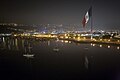
Ensenada is a city in Ensenada Municipality, Baja California, situated on the Pacific Coast of Mexico. Located on the Bahía de Todos Santos, the city had a population of 279,765 in 2018, making it the third-largest city in Baja California. The city is an important international trade center and home to the Port of Ensenada, the second-busiest port in Mexico. Ensenada is a major tourist destination, owing to its warm Mediterranean climate and proximity to the Pacific Ocean, and is commonly known as La Cenicienta del Pacífico.
Baja California is a state in Northwest Mexico that is divided into seven municipalities. According to the 2020 Mexican Census, Baja California is the 13th most populous state with 3,769,020 inhabitants and the 12th largest by land area spanning 73,290.08 square kilometres (28,297.46 sq mi).
Tecate is a city in Tecate Municipality, Baja California. It is across the Mexico–US border from Tecate, California. As of 2019, the city had a population of 108,860 inhabitants, while the metropolitan area has a population of 132,406 inhabitants. Tecate is part of the San Diego-Tijuana metropolitan area and the largest city between Tijuana and Mexicali. Tecate is a regional economic hub and popular tourist destination, known as home to the Tecate Port of Entry and to Tecate Beer.

The municipality of Ensenada is the fourth-largest municipality in Mexico with a land area of 19,526.8 km2 (7,539.3 sq mi) in 2020, about the same size as Hidalgo state and larger than five Mexican states.

Centro de Enseñanza Técnica y Superior (CETYS) is a private Institution of Higher Education founded in 1961, located in the state of Baja California. CETYS is a three-campus university system in Engineering, Business and the Social Sciences.

Tecate is a municipality in the Mexican state of Baja California. Its municipal seat is located in the city of Tecate. According to the 2020 census, it had a population of 108,440 inhabitants. The municipality has an area of 3,079.0 km².

Tijuana Municipality is a municipality in the Mexican state of Baja California. Its municipal seat is located in the city of Tijuana. According to the 2020 census, the municipality had a population of 1,922,523. Luis Arturo González Cruz of the MORENA is the current municipal president. The municipality comprises the largest part of the Tijuana metropolitan area.
The Ensenada Institute of Technology is a college level technology institution located in the city of Ensenada, Baja California, Mexico. Inaugurated in 1997, the college is one of three regional institutes of technology part of the national system of institutes of technology in the Mexican state of Baja California.
The metropolitan areas of Mexico have been traditionally defined as the group of municipalities that heavily interact with each other, usually around a core city. The phenomenon of metropolization in Mexico is relatively recent, starting in the 1940s, and due to the accelerated level of urbanization in the country, the definition of a metropolitan area is reviewed periodically by the Mexican population and census authorities.
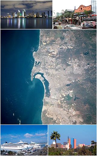
San Diego–Tijuana is an international transborder agglomeration, straddling the border of the adjacent North American coastal cities of San Diego, California, United States and Tijuana, Baja California, Mexico. The 2012 population of the region was 4,922,723, making it the largest bi-national conurbation shared between the United States and Mexico, the second-largest shared between the US and another country. In its entirety, the region consists of San Diego County in the United States and the municipalities of Tijuana, Rosarito Beach, and Tecate in Mexico. It is the third most populous region in the California–Baja California region, smaller only than the metropolitan areas of Greater Los Angeles and the San Francisco Bay Area.
In Mexico, some municipalities and Mexico City are divided into boroughs for administrative purposes. Boroughs are known as delegaciones, or in the case of Mexico City. Boroughs can either be second-level semi-autonomous administrative divisions or third-level non-autonomous administrative divisions. The limits, nature and competencies of boroughs are usually described in the constitutions of the states they are part of, or in the laws enacted by the municipality itself, and may differ from municipality to municipality.
Valle de las Palmas is located between two hamlets Espuela and Seco in the municipalities of Tijuana and Tecate, Baja California, Mexico. It is the site of a long-term planned urban development which would take advantage of proximity to the existing cities of Tijuana to the north west and Mexicali to the north east to create a similar sized city of one million people by the year 2030, on Mexican Federal Highway 3 around an existing industrial park and university campus Unidad Valle De Las Palmas. The first project in Valle de las Palmas, named Valle San Pedro, is proposed by the Mexican Federal Government, the State of Baja California, Urbi and Banobras. It has been certified as the first Integral Sustainable Urban Development or DUIS in Mexico, which establishes criteria in collaboration with Interamerican Development Bank IDB to evaluate projects that will receive inter-secretarial technical support and public investment. The locality reported a population of 1,860 inhabitants in the 2010 federal census. It is located at an altitude of 282 m. above sea level.
Transportation in San Diego–Tijuana occurs by various means. Though, in the four cities of San Diego, Tijuana, Tecate, and Rosarito Beach, the automobile serves as most important means of transportation. The international metropolitan region maintains an intricate highway infrastructure. As a large metropolitan area in Western North America, many roadways, including Interstates, State Routes, and Mexican Federal Highways, hold a terminus in the area. These roads have grown accustomed to support the masses of the commuting populace within the international region and are constantly being expanded and/or renovated. Transportation is a crucial issue in the metropolitan area. The streets and highways of the region affect environmental health and have influence over the degree of regional connectivity. Binational discussions about coordinating public transportation across the border are currently underway. San Diego–Tijuana is the site of two major international airports and numerous regional airports. It is also the site of the Port of San Diego and miles from the nearby Port of Ensenada.

La Mesa is a borough of the municipality of Tijuana in Baja California, Mexico.
The Autonomous University of Baja California (UABC) (Spanish: Universidad Autónoma de Baja California) is a public institution of higher education in Baja California. Established in 1957, UABC has its headquarters located in the city of Mexicali.

Grupo Cadena, formerly known as Cadena Baja California, was a media company based in Tijuana, Baja California, Mexico, with business offices in San Diego, California, United States. CBC had media properties located in Tijuana, Ensenada, Tecate and Mexicali.
Same-sex marriage has been legal in Baja California since 3 November 2017 when the Secretary General of Government, Francisco Rueda Gómez, instructed the state's civil registry to immediately begin issuing marriage licenses to same-sex couples and cease enforcement of the state's same-sex marriage ban. This was in line with jurisprudence established by the Mexican Supreme Court, which has ruled that same-sex marriage bans violate Articles 1 and 4 of the Constitution of Mexico. Previously, Baja California had banned same-sex marriage both by statute and in its state constitution.
California Odha Zertuche Díaz (1923–1991) was a Mexican civil engineer and is credited as the primary developer of the drinking water and sewerage system in Ensenada, Mexico.