List of Charleroi Metro stations

Last updated

Charleroi Metro network
Central loop
BSicon uhCONTg.svg
To Anderlues
and Gosselies
BSicon uhABZgl+l.svg
BSicon utSTR+ra.svg
BSicon utABZg+l.svg
BSicon utTHSTteq.svg
Beaux-Arts
Ouest
BSicon BAHN.svg
BSicon utINTae.svg
BSicon utSTR.svg
Villette
BSicon uhHSTae.svg
BSicon utSTR.svg
Gare Central
BSicon BAHN.svg
BSicon uINT.svg
BSicon utSTR.svg
Sambre
BSicon uHST.svg
BSicon utSTR.svg
Tirou
BSicon utHSTa@f.svg
BSicon utSTR.svg
Parc
BSicon utHST.svg
BSicon utSTR.svg
Janson
BSicon utHST.svg
BSicon utSTR.svg
Waterloo
BSicon utTHSTtaq.svg
BSicon utSTRr.svg
BSicon utABZgl+l.svg
BSicon utSTR+r.svg
To Châtelet
BSicon uextCONTf.svg
BSicon utCONTf.svg
To Soleilmont
Anderlues line
BSicon unENDEa.svg
BSicon uHST.svg
Monument
BSicon ulHST.svg
BSicon unSTR.svg
Route de la Station
BSicon uHST.svg
Jonction
BSicon uABZgl+l.svg
BSicon uKDSTeq.svg
Depot
BSicon ulHST.svg
BSicon unSTR.svg
Route de Thuin
BSicon uPSL.svg
BSicon ulHST.svg
BSicon unSTR.svg
Surchiste
BSicon ulHST.svg
BSicon unSTR.svg
Coron du Berger
BSicon uHST.svg
Pétria
BSicon utHSTae.svg
Fontaine
BSicon uhHSTae.svg
Paradis
BSicon uHST.svg
Leernes
BSicon uHST.svg
Morgnies
BSicon uhHSTae.svg
Moulin
BSicon utHSTae.svg
De Cartier
BSicon uhHSTae.svg
Providence
BSicon utHSTae.svg
Dampremy
BSicon uABZg+l.svg
BSicon uCONTfq.svg
To Gosselies
BSicon uhHSTa.svg
Piges
BSicon uhCONTf.svg
To central loop
Gosselies line
Faubourg de Bruxelles
BSicon uKHSTa.svg
BSicon unSTR.svg
BSicon uKSTRe.svg
BSicon unSTRl.svg
BSicon unSTR+r.svg
Bruyerre
BSicon NULg.svg
BSicon unHST.svg
BSicon NULf.svg
BSicon unHST.svg
Rue du Chemin de Fer
Calvaire
BSicon NULg.svg
BSicon unHST.svg
BSicon NULf.svg
BSicon unHST.svg
Emailleries
Léopold
BSicon NULg.svg
BSicon unHST.svg
BSicon NULf.svg
BSicon unHST.svg
City Nord
BSicon unSTR.svg
BSicon NULf.svg
BSicon unHST.svg
Chaussée de Fleurus
BSicon unSTR+l.svg
BSicon uKSTRa.svg
BSicon unSTR.svg
BSicon unSTRr.svg
Carrosse
BSicon uHST.svg
Madeleine
BSicon uHST.svg
BSicon uABZgl+l.svg
BSicon uKDSTeq.svg
Depot
Rue Berteau
BSicon uHST.svg
Chaussée de Gilly
BSicon uHST.svg
Puissant
BSicon uHST.svg
Saint Antoine
BSicon uHST.svg
Marie Curie
BSicon uHST.svg
Deschassis
BSicon uHST.svg
La Planche
BSicon uHST.svg
Sacré Madame
BSicon uHST.svg
BSicon uSTR2.svg
BSicon uSTRc3.svg
BSicon uSTRc1.svg
BSicon uSTR+4.svg
To Anderlues
BSicon uCONTg.svg
BSicon uSTR.svg
BSicon uABZg+l.svg
BSicon uSTRr.svg
Piges
BSicon uhHSTa.svg
BSicon uhCONTf.svg
To central loop
Soleilmont line
BSicon utCONTg.svg
To central loop
BSicon utUST.svg
BSicon utHST.svg
Samaritaine
BSicon utHST.svg
Gazomètre
BSicon utHST.svg
Gilly
BSicon uhtSTRea.svg
BSicon utHST.svg
Marabout
BSicon utHSTe@g.svg
Sart-Culpart
BSicon uKHSTe.svg
Soleilmont
Châtelet line
BSicon uextCONTg.svg
To central loop
BSicon uexhtSTRe.svg
BSicon uexhFOW.svg
BSicon uexhHST.svg
Neuville
BSicon uexhHSTe.svg
Chet
BSicon uexHST.svg
Pensée
BSicon uextHSTae.svg
Centenaire
BSicon uexHST.svg
Champeau (no track)
BSicon uexHST.svg
Léopold (no track)
BSicon uexCONTf.svg
to Châtelet
(unfinished)
BSicon unSTRq.svg thin line indicates single track section

The following is the list of the 49 stations (25 premetro stations, and 24 tram stops) of the Charleroi Metro in Belgium, and includes all stations in the Charleroi area network, as well as tram stops that are also served by premetro lines. It also includes 4 unopened stations on the unfinished line to Châtelet that will be renewed and extended.

Contents

Central loop

The "central loop" of the Charleroi Metro is grade separated (except in the vicinity of Tirou) and thus is the portion of the network that effectively operates as an almost fully metro-standards rapid transit system. There are 9 stations on the central loop, and these are served by all four Charleroi Metro lines:

NameTypeCharacterLinesOpenedMunicipalityCoords
Sud tram Surface   M1    M2    M3    M4  October 1973 Charleroi 50°24′17″N4°26′19″E / 50.40472°N 4.43861°E / 50.40472; 4.43861 (Charleroi Metro Gare Central)
Villette Premetro Viaduct  M1  M2  M3  M4 21 July 1976Charleroi 50°24′23″N4°26′6″E / 50.40639°N 4.43500°E / 50.40639; 4.43500 (Charleroi Metro Villette)
Ouest Premetro Underground  M1  M2  M3  M4 30 June 1980Charleroi 50°24′38″N4°26′11″E / 50.41056°N 4.43639°E / 50.41056; 4.43639 (Charleroi Metro Ouest)
Beaux-Arts PremetroUnderground M1  M2  M3  M4 24 or 29 May 1983Charleroi 50°24′53″N4°26′35″E / 50.41472°N 4.44306°E / 50.41472; 4.44306 (Charleroi Metro Beaux-Arts)
Waterloo PremetroUnderground M1  M2  M3  M4 28 August 1992Charleroi 50°25′02″N4°27′02″E / 50.4172°N 4.45062°E / 50.4172; 4.45062 (Charleroi Metro Waterloo)
Janson PremetroUnderground M1  M2  M3  M4 30 August 1996Charleroi 50°24′47″N4°27′07″E / 50.41306°N 4.45194°E / 50.41306; 4.45194 (Charleroi Metro Janson)
Parc PremetroUnderground M1  M2  M3  M4 30 August 1996Charleroi 50°24′34″N4°26′55″E / 50.40944°N 4.44861°E / 50.40944; 4.44861 (Charleroi Metro Parc)
Tirou TramSurface M1  M2  M3  M4 27 February 2012Charleroi 50°24′22″N4°26′44″E / 50.40611°N 4.44556°E / 50.40611; 4.44556 (Charleroi Metro Tirou)
Sambre TramSurface M1  M2  M3  M4 3 January 2023 [1] Charleroi 50°24′19″N4°26′31″E / 50.40528°N 4.44194°E / 50.40528; 4.44194 (Charleroi Metro Sambre)

Anderlues line: Lines M1 & M2

The following 10 stations (including one station that also serves the M3 line) and 6 tram stops are found on the M1 and M2 lines of the Charleroi Metro:

NameTypeCharacterLinesOpenedMunicipalityCoords
Piges Premetro Viaduct  M1    M2    M3  30 June 1980 Dampremy (Charleroi) 50°24′55″N4°26′14″E / 50.41528°N 4.43722°E / 50.41528; 4.43722 (Charleroi Metro Piges)
Dampremy PremetroUnderground M1  M2 24 or 29 May 1983Dampremy (Charleroi) 50°25′00″N4°25′43″E / 50.41667°N 4.42861°E / 50.41667; 4.42861 (Charleroi Metro Dampremy)
Providence PremetroViaduct M1  M2 22 or 23 August 1992 Marchienne-au-Pont (Charleroi) 50°24′46″N4°24′27″E / 50.41278°N 4.40750°E / 50.41278; 4.40750 (Charleroi Metro Providence)
De Cartier PremetroUnderground M1  M2 22 or 23 August 1992Marchienne-au-Pont (Charleroi) 50°24′25″N4°23′43″E / 50.40694°N 4.39528°E / 50.40694; 4.39528 (Charleroi Metro De Cartier)
Moulin PremetroViaduct M1  M2 22 or 23 August 1992 Monceau-sur-Sambre (Charleroi) 50°24′31″N4°23′14″E / 50.40861°N 4.38722°E / 50.40861; 4.38722 (Charleroi Metro Moulin)
Morgnies PremetroSurface M1  M2 21 June 1982Monceau-sur-Sambre (Charleroi) 50°24′15″N4°21′54″E / 50.40417°N 4.36500°E / 50.40417; 4.36500 (Charleroi Metro Morgnies)
Leernes PremetroSurface M1  M2 21 June 1982 Leernes (Fontaine-l'Évêque) 50°24′06″N4°20′50″E / 50.40167°N 4.34722°E / 50.40167; 4.34722 (Charleroi Metro Leernes)
Paradis PremetroViaduct M1  M2 21 June 1982Fontaine-l'Évêque 50°24′19″N4°20′17″E / 50.40528°N 4.33806°E / 50.40528; 4.33806 (Charleroi Metro Paradis)
Fontaine PremetroUnderground M1  M2 30 August 1986Fontaine-l'Évêque 50°24′24″N4°19′37″E / 50.40667°N 4.32694°E / 50.40667; 4.32694 (Charleroi Metro Fontaine)
Pétria PremetroSurface M1  M2 30 August 1986Fontaine-l'Évêque 50°24′22″N4°18′42″E / 50.40611°N 4.31167°E / 50.40611; 4.31167 (Charleroi Metro Pétria)
Coron du Berger Tram Surface M1  M2 Fontaine-l'Évêque 50°24′23″N4°18′07″E / 50.40639°N 4.30194°E / 50.40639; 4.30194 (Charleroi Metro Coron du berger)
SurchisteTramSurface M1  M2 Fontaine-l'Évêque 50°24′23″N4°17′37″E / 50.40639°N 4.29361°E / 50.40639; 4.29361 (Charleroi Metro Surchiste)
Route de ThuinTramSurface M1  M2  Anderlues 50°24′12″N4°17′14″E / 50.40333°N 4.28722°E / 50.40333; 4.28722 (Charleroi Metro Route de Thuin)
JonctionTramSurface M1  M2 Anderlues 50°24′00″N4°16′59″E / 50.40000°N 4.28306°E / 50.40000; 4.28306 (Charleroi Metro Jonction)
Route de la StationTramSurface M1  M2 Anderlues 50°24′12″N4°16′37″E / 50.40333°N 4.27694°E / 50.40333; 4.27694 (Charleroi Metro Route de le station)
MonumentTramSurface M1  M2 Anderlues 50°24′21″N4°16′18″E / 50.40583°N 4.27167°E / 50.40583; 4.27167 (Charleroi Metro Monument)

Gosselies line: Line M3

The following 18 tram stops and the Piges premetro station which is also served by the M1 and M2 lines are found on just the M3 line:

NameTypeCharacterLinesOpenedMunicipalityCoords
Piges PremetroViaduct  M1    M2    M3  30 June 1980 Dampremy (Charleroi) 50°24′55″N4°26′14″E / 50.41528°N 4.43722°E / 50.41528; 4.43722 (Charleroi Metro Piges)
Sacré MadameTramSurface M3 22 June 2013Dampremy (Charleroi) 50°25′05″N4°26′19″E / 50.41806°N 4.43861°E / 50.41806; 4.43861 (Charleroi Metro Sacré Madame)
La PlancheTramSurface M3 22 June 2013Dampremy (Charleroi) 50°25′20″N4°26′25″E / 50.42222°N 4.44028°E / 50.42222; 4.44028 (Charleroi Metro La Planche)
DeschassisTramSurface M3 22 June 2013 Lodelinsart (Charleroi) 50°25′38″N4°26′26″E / 50.42722°N 4.44056°E / 50.42722; 4.44056 (Charleroi Metro Deschassis)
Marie CurieTramSurface M3 22 June 2013Lodelinsart (Charleroi) 50°25′51″N4°26′27″E / 50.43083°N 4.44083°E / 50.43083; 4.44083 (Charleroi Metro Marie Curie)
Saint AntoineTramSurface M3 22 June 2013 Jumet (Charleroi) 50°26′08″N4°26′26″E / 50.43556°N 4.44056°E / 50.43556; 4.44056 (Charleroi Metro Saint-Antoine)
PuissantTramSurface M3 22 June 2013Jumet (Charleroi) 50°26′24″N4°26′18″E / 50.44000°N 4.43833°E / 50.44000; 4.43833 (Charleroi Metro Puissant)
Chaussée de GillyTramSurface M3 22 June 2013Jumet (Charleroi) 50°26′36″N4°26′13″E / 50.44333°N 4.43694°E / 50.44333; 4.43694 (Charleroi Metro Chaussée de Gilly)
Rue BerteauTramSurface M3 22 June 2013Jumet (Charleroi) 50°26′48″N4°26′08″E / 50.44667°N 4.43556°E / 50.44667; 4.43556 (Charleroi Metro Rue Bertau)
MadeleineTramSurface M3 22 June 2013Jumet (Charleroi) 50°27′08″N4°25′59″E / 50.45222°N 4.43306°E / 50.45222; 4.43306 (Charleroi Metro Madeleine)
CarrosseTramSurface M3 22 June 2013 Gosselies (Charleroi) 50°27′33″N4°25′49″E / 50.45917°N 4.43028°E / 50.45917; 4.43028 (Charleroi Metro Carrosse)
Léopold ↓TramSurface M3 22 June 2013Gosselies (Charleroi) 50°27′55″N4°25′54″E / 50.46528°N 4.43167°E / 50.46528; 4.43167 (Charleroi Metro Léopold)
Calvaire ↓TramSurface M3 22 June 2013Gosselies (Charleroi) 50°28′07″N4°25′56″E / 50.46861°N 4.43222°E / 50.46861; 4.43222 (Charleroi Metro Calvaire)
Bruyerre ↓TramSurface M3 22 June 2013Gosselies (Charleroi) 50°28′24″N4°26′08″E / 50.47333°N 4.43556°E / 50.47333; 4.43556 (Charleroi Metro Bruyerre)
Chaussée de Fleurus ↑TramSurface M3 22 June 2013Gosselies (Charleroi) 50°27′50″N4°26′12″E / 50.46389°N 4.43667°E / 50.46389; 4.43667 (Charleroi Metro Chaussée de Fleurus)
City Nord ↑TramSurface M3 22 June 2013Gosselies (Charleroi) 50°28′05″N4°26′18″E / 50.46806°N 4.43833°E / 50.46806; 4.43833 (Charleroi Metro City Nord)
Emailleries ↑TramSurface M3 22 June 2013Gosselies (Charleroi) 50°28′16″N4°26′19″E / 50.47111°N 4.43861°E / 50.47111; 4.43861 (Charleroi Metro Emailleries)
Rue du Chemin de Fer ↑TramSurface M3 22 June 2013Gosselies (Charleroi) 50°28′22″N4°26′20″E / 50.47278°N 4.43889°E / 50.47278; 4.43889 (Charleroi Metro Rue du Chemin de Fer)
Faubourg de BruxellesTramSurface M3 22 June 2013Gosselies (Charleroi) 50°28′37″N4°26′24″E / 50.47694°N 4.44000°E / 50.47694; 4.44000 (Charleroi Metro Faubourg de Bruxelles)

Gilly line: Line M4

The following 6 stations are found on the M4 line of the Charleroi Metro:

NameTypeCharacterLinesOpenedMunicipalityCoords
Samaritaine PremetroUnderground  M4  28 August 1992 Charleroi 50°25′12″N4°27′41″E / 50.42000°N 4.46139°E / 50.42000; 4.46139 (Charleroi Metro Samaritaine)
Gazomètre PremetroUnderground M4 28 August 1992 Gilly (Charleroi) 50°25′19″N4°28′26″E / 50.42194°N 4.47389°E / 50.42194; 4.47389 (Charleroi Metro Gazomètre)
Gilly PremetroUnderground M4 28 August 1992Gilly (Charleroi) 50°25′25″N4°28′45″E / 50.42361°N 4.47917°E / 50.42361; 4.47917 (Charleroi Metro Gilly)
Marabout PremetroUnderground M4 27 February 2012Gilly (Charleroi) 50°25′37″N4°29′14″E / 50.42694°N 4.48722°E / 50.42694; 4.48722 (Charleroi Metro Marabout)
Sart-Culpart PremetroSurface M4 27 February 2012Gilly (Charleroi) 50°25′45″N4°29′43″E / 50.42917°N 4.49528°E / 50.42917; 4.49528 (Charleroi Metro Sart-Culpart)
Soleilmont PremetroSurface M4 27 February 2012Gilly (Charleroi) 50°25′49″N4°30′10″E / 50.43028°N 4.50278°E / 50.43028; 4.50278 (Charleroi Metro Soleilmont)

Châtelet line: Line M5: Not completed

The following 4 stations are found on the unfinished line to Châtelet. These out-of-service stations were completed in late 1980s but never opened for service. There were 4 more stations planned (construction of some of them started but did not finish) but the line has been abandoned, and the surface building of the Centennaire station was demolished in 2010s (while the underground structure still remains intact). In early 2021 a decision was made to finish and open the line (see Métro Léger de Charleroi § Châtelet line: Line M5 branch for more details).

NameTypeCharacterLinesOpenedMunicipalityCoords
NeuvillePremetroViaduct M5 Montignies-sur-Sambre (Charleroi) 50°24′53″N4°27′32″E / 50.41468622399911°N 4.458794129598287°E / 50.41468622399911; 4.458794129598287 (Charleroi Metro Neuville)
ChetPremetroViaduct M5 Montignies-sur-Sambre (Charleroi) 50°24′37″N4°27′52″E / 50.41032°N 4.46456°E / 50.41032; 4.46456 (Charleroi Metro Chet)
PenséePremetroSurface M5 Montignies-sur-Sambre (Charleroi) 50°24′23″N4°28′07″E / 50.40632°N 4.4685°E / 50.40632; 4.4685 (Charleroi Metro Pensée)
CentenairePremetroUnderground M5 Montignies-sur-Sambre (Charleroi) 50°24′11″N4°28′46″E / 50.40307°N 4.47933°E / 50.40307; 4.47933 (Charleroi Metro Centenaire)
ChampeauPremetroSurface (No Track) M5 Montignies-sur-Sambre (Charleroi)50°24'11.4"N 4°29'16.3"E
LéopoldPremetroSurface (No Track) M5 Montignies-sur-Sambre (Charleroi)50°24'26.7"N 4°29'34.1"E

See also

Related Research Articles

<span class="mw-page-title-main">Warsaw Metro</span> Rapid transit system in Warsaw

The Warsaw Metro is a rapid transit underground system serving the Polish capital Warsaw. It currently consists of two lines, the north–south Line M1 which links central Warsaw with its densely populated northern and southern districts, and the east–west Line M2. Three more lines are still being planned. The system is operated by Metro Warszawskie sp. z o.o., a company owned by the city, and managed by Zarząd Transportu Miejskiego w Warszawie. It is currently the only metro system in Poland.

<span class="mw-page-title-main">Cross-platform interchange</span> Transfer station design

A cross-platform interchange is a type of interchange between different lines at a metro station. The term originates with the London Underground; such layouts exist in other networks but are not commonly so named. In the United States and Canada, it is often referred to as a cross-platform transfer.

<span class="mw-page-title-main">Bucharest Metro</span> Rapid transit system in Romania

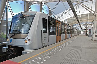
The Bucharest Metro is an underground rapid transit system that serves Bucharest, the capital of Romania. It first opened for service on 16 November 1979. The network is run by Metrorex. One of two parts of the larger Bucharest public transport network, Metrorex has an average of approximately 720,000 passenger trips per weekday, compared to the 1,180,000 daily riders on Bucharest's STB transit system. In total, the Metrorex system is 79.1 kilometres (49.2 mi) long and has 64 stations.

<span class="mw-page-title-main">Brussels Metro</span> Public rapid-transit system serving the Brussels-Capital Region, Belgium

The Brussels Metro is a rapid transit system serving a large part of the Brussels-Capital Region of Belgium. It consists of four conventional metro lines and three premetro lines. The metro-grade lines are M1, M2, M5, and M6 with some shared sections, covering a total of 39.9 kilometres (24.8 mi), with 59 metro-only stations. The premetro network consists of three tram lines that partly travel over underground sections that were intended to be eventually converted into metro lines. Underground stations in the premetro network use the same design as metro stations. A few short underground tramway sections exist, so there is a total of 52.0 kilometres (32.3 mi) of underground metro and tram network. There are a total of 69 metro and premetro stations as of 2011.

<span class="mw-page-title-main">Copenhagen Metro</span> Rapid transit railway in Copenhagen, Denmark

The Copenhagen Metro is a 24/7 light rapid transit system in Copenhagen, Denmark, serving the municipalities of Copenhagen, Frederiksberg, and Tårnby.

<span class="mw-page-title-main">Ankara Metro</span> Subway system in Turkey

The Ankara Metro is the rapid transit system serving Ankara, the capital of Turkey. At present, Ankara's rapid transit system consists of two metro lines – the Batıkent Metrosu (M1) and the new Keçiören Metrosu (M4) line opened in 2017, along with the Ankaray line. The Ankaray, the M1 and M4 lines, together transported 104.1 million passengers in 2014. That corresponds to a ridership of approximately 289,155 per day. In February 2019 all the lines that used to run M1, M2 and M3 were merged to create one line, M1.

<span class="mw-page-title-main">Budapest Metro</span> Rapid transit system of Budapest, Hungary

The Budapest Metro is the rapid transit system in the Hungarian capital Budapest. It is the world's oldest electrified underground railway system, and the second oldest underground railway system with multiple stations, after the originally steam-powered London Underground.

<span class="mw-page-title-main">Trams in Brussels</span> Belgian tram system

The Brussels tramway network is a tram system serving a large part of the Brussels-Capital Region of Belgium. It is the 16th largest tram system in the world by route length, in 2017 providing 149.1 million journeys over routes 140.6 km (87.4 mi) in length. In 2018, it consisted of 18 tram lines. Brussels trams are operated by STIB/MIVB, the local public transport company.

<span class="mw-page-title-main">Premetro</span>

A premetro is a tramway or light railway which includes segments built to rapid transit standards, generally as part of a process of conversion to a metro-standards railway usually by the construction of tunnels in the central city area.

<span class="mw-page-title-main">Istanbul Metro</span> Istanbul railway network

The Istanbul Metro is a rapid transit railway network that serves the city of Istanbul, Turkey. Apart from the M11 line, which is operated by TCDD Taşımacılık, the system is operated by Metro Istanbul, a public enterprise controlled by the Istanbul Metropolitan Municipality. The oldest section of the metro is the M1 line, which opened in 1989. As of January 2024, the system now includes 138 stations in service, with 55 more under construction.

<span class="mw-page-title-main">Métro Léger de Charleroi</span> Light rail network in Charleroi, Belgium

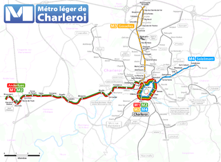
The Métro Léger de Charleroi is a 33-kilometre (21 mi) light rail network in Belgium. The system consists of a loop line around central Charleroi and three branches towards the suburbs of Gilly, Anderlues and Gosselies. Another branch to Châtelet was partially built, never entered service, but will finally do so in 2026.

<span class="mw-page-title-main">Lausanne Métro</span> Transit system of Lausanne, Switzerland

The Lausanne Métro system is a two-line urban rail transport system in Lausanne, Vaud, Switzerland. Around a quarter of the system has been used for urban rail transport since 1877, when the route between the city centre and Ouchy opened as Switzerland's first public funicular railway. The network is owned by two distinct companies and operated by a third.

<span class="mw-page-title-main">Premetro (Buenos Aires)</span> Light rail system in Buenos Aires

The Premetro is a 7.4-kilometer long (4.6 mi) light rail line that runs along the outskirts of Buenos Aires, connecting with the Buenos Aires Underground line E, at Plaza de los Virreyes station and then to General Savio, with a short branch to Centro Cívico. It opened in 1987 and is operated by Metrovías. Originally, the Premetro was to include many more lines, but shortly after the privatisation of the railways the projects were postponed and never materialised and only "Premetro E2" was built.

<span class="mw-page-title-main">Palais metro station</span> Chareloi metro station

Beaux-Arts is the largest station in the Charleroi Metro network, located in Charleroi downtown, in fare zone 1. Because of its situation on a slope, the station terminates on a viaduct at one end, and in a tunnel at the other end.

Line M1 is a line of the Charleroi Metro in Belgium operated by TEC Charleroi, running from the Monument tram stop in Anderlues to the metro loop around central Charleroi, before heading back to Anderlues. Line M1 was created on 27 February 2012 to replace former lines 88 and 89 after completion of the loop around central Charleroi. Introduction of new line numbers in February 2012 coincided with the formal association of colors to line numbers. The official color for line M1 is red.

<span class="mw-page-title-main">Charleroi Metro line 2</span> Metros line of the city Charleroi

Line M2 is a line of the Charleroi Metro in Belgium operated by TEC Charleroi, running from the Monument tram stop in Anderlues to the metro loop around central Charleroi, before heading back to Anderlues. Line M2 was created on 27 February 2012 to replace former lines 88 and 89 after completion of the loop around central Charleroi. Introduction of new line numbers in February 2012 coincided with the formal association of colors to line numbers. The official color for line M2 is green.

<span class="mw-page-title-main">Charleroi Metro line 4</span> Transit line in Charleroi, Belgium

Line 4 is a line of the Charleroi Metro in Belgium operated by TEC Charleroi, running from Soleimont in Gilly to the loop around downtown Charleroi, before heading back to Soleilmont.

<span class="mw-page-title-main">Charleroi Metro line 3</span>

Line M3 is a line of the Charleroi Metro in Belgium operated by TEC Charleroi, running from Gosselies to the loop around downtown Charleroi, before heading back to Gosselies.

<span class="mw-page-title-main">Opera (Antwerp premetro station)</span> Premetro station in Antwerp, Belgium

Opera is a station in the Antwerp premetro network, lying under the Leien near the Teniersplaats in the city centre. The station was opened on March 25, 1975, at the initial opening of the Antwerp premetro network. The station was temporarily closed in 2016 in order to undergo a full renovation and expansion and reopened in its current form on December 8, 2019. The station lies in the immediate proximity of the Antwerp opera building and is a part of the central east-west premetro axis. It is served by the tram routes 3, 5, 9, 10 and 15.

References