Related Research Articles
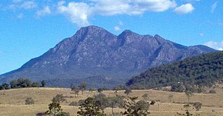
Mount Barney National Park is a national park in Queensland (Australia), 90 km southwest of Brisbane. It amalgamated the adjacent Mount Lindesay National Park in 1980. It is part of the Scenic Rim Important Bird Area, identified as such by BirdLife International because of its importance in the conservation of several species of threatened birds.

The Montebello Islands, also rendered as the Monte Bello Islands, are an archipelago of around 174 small islands lying 20 km (12 mi) north of Barrow Island and 130 km (81 mi) off the Pilbara coast of north-western Australia. The islands form a marine conservation reserve of 58,331 ha administered by the Western Australian Department of Environment and Conservation. The islands were the site of three British atmospheric nuclear weapons tests in 1952 and 1956.

Ilhéu Raso is an uninhabited volcanic island of 5.76 square kilometres in the Barlavento archipelago of Cape Verde. It is flanked by the smaller Branco islet to the west and by São Nicolau island on its eastern side. The distance from the island of São Nicolau is 15 kilometres. Together with Santa Luzia and Ilhéu Branco, Ilhéu Raso is on the tentative list of UNESCO's World Heritage Sites. Since 1990, the islet is part of the protected area Reserva Natural Integral de Santa Luzia.

The Tuscan Archipelago is a chain of islands between the Ligurian Sea and Tyrrhenian Sea, west of Tuscany, Italy.

Jaco Island is an uninhabited island in East Timor, a country occupying the eastern end of the island of Timor in the Lesser Sunda Islands in Southeast Asia. It lies off the eastern tip with Cape Cutcha of the island of Timor.

Atauro, also known as Kambing Island, is an island and municipality of East Timor. Atauro is a small oceanic island situated north of Dili, on the extinct Wetar segment of the volcanic Inner Banda Arc, between the Indonesian islands of Alor and Wetar. The nearest island is the Indonesian island of Liran, 13.0 km (8.1 mi) to the northeast. At the 2015 census, it had 9,274 inhabitants.

Wetar Strait is an international strait in Southeast Asia. It separates the island of Wetar from the eastern part of the island of Timor. The strait is also the eastern portion of a pair of international straits, the other one being Ombai Strait; the two straits combine to link the Indian Ocean with the Pacific Ocean.

Monte Gordo is a mountain on the island of São Nicolau, Cape Verde. At 1,312 m elevation, it is the island's highest point. It is situated in the western part of the island, 6 km west of the island capital Ribeira Brava. The mountain is of volcanic origin, less than 1 million years old. The boundary of the municipalities Tarrafal de São Nicolau and Ribeira Brava runs over the mountain. It is part of the Monte Gordo Natural Park.

Bald Island is an island that is located in the Great Southern region of Western Australia. The island is 1.5 kilometres (1 mi) offshore from Cheynes Beach and is a protected area managed by the Department of Parks and Wildlife.

The Sikorski Glacier is a small glacier in the north-eastern part of the Noville Peninsula, Thurston Island, Ellsworth Land, Antarctica. It flows north-east to the Bellingshausen Sea between Mount Palmer and Mount Feury. It was first roughly delineated from aerial photos taken by the USN's Operation Highjump in 1946–47. It was named by the Advisory Committee on Antarctic Names (US-ACAN) for Stephen Sikorski, electronics technician on USS Glacier, who assisted in setting up an automatic weather station on Thurston Island during the USN's Bellingshausen Sea Expedition in February 1960.
Coffin Island is an island that is located in the Great Southern region of Western Australia. The island is 300 metres (984 ft) offshore from Two Peoples Bay Nature Reserve and the island is also a protected area making up part of the reserve. With an area of 28 hectares the island is made up mostly of granite.

Cape Batterbee is a small, rocky point on the coast, the most northerly cape of Enderby Land. It is located 92 km north of Mount Elkins.

Barnard Point is a headland which marks the south-east side of the entrance to False Bay on the south side of Livingston Island in the South Shetland Islands, Antarctica. It is situated on Rozhen Peninsula, 1.5 km (1 mi) north-north-west of Botev Point and 6.6 km (4 mi) south-east of Miers Bluff.

Fogo Natural Park, on the island of Fogo, is one of ten "natural parks" in the country of Cape Verde. The protected area is 84.69 km2 (32.70 sq mi), which is 17.8% of the total area of the island. 50% of the park lies within the municipality Santa Catarina do Fogo, 28% in municipality of Mosteiros and 22% in São Filipe. The natural park is situated in the interior of the island, and covers the volcano Pico do Fogo, its crater and crater rim (Bordeira) and the forest of Monte Velha. The volcano is active; the most recent eruption was in 2014-15.

Mount Elder is a 940-metre (3,080 ft) mountain lying between Endurance Glacier and Mount Pendragon on Elephant Island, in the South Shetland Islands of Antarctica. It was named by the UK Antarctic Place-Names Committee for Captain John P. Elder, Royal Engineers, surveyor of the U.K. Joint Services Expedition to Elephant Island in 1970–71.
Kartografov Island is a small coastal island lying in the western part of the mouth of Harald Bay, Oates Land, Antarctica. It was photographed by U.S. Navy Operation Highjump (1946–47), the Soviet Antarctic Expedition (1957–58) and the Australian National Antarctic Research Expedition (1959). The island was named "Ostrov Kartografov" by the Soviet expedition.
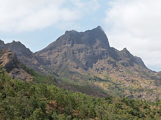
The Serra do Pico de Antónia is a mountain range in the centre of the island of Santiago in the Cape Verde archipelago. It contains the Pico de Antónia, at 1,392 m (4,567 ft) the highest point of the island. It is protected as a natural park, covering 28.73 km2 (11.09 sq mi). The natural park covers the connected mountain ranges of Serra do Pico de Antónia and of Rui Vaz.

Subaun is a 23,665 ha Important Bird Area (IBA) in East Timor, a country occupying the eastern end of the island of Timor in the Lesser Sunda Islands of Wallacea.

Mount Archer is a rock peak immediately south of Archer Point on the west side of Harald Bay in Antarctica. The peak was mapped from aerial photos taken in February 1959 by the ANARE led by Phillip Law. It is named after Archer Point.

The Ryder Bay Islands Important Bird Area is a 520 ha designated site on the south-east coast of Adelaide Island, Antarctica. It has been identified as an Important Bird Area (IBA) by BirdLife International because it supports significant numbers of breeding seabirds, notably south polar skuas. The site encompasses the Léonie Islands lying at the mouth of Ryder Bay, as well as Rothera Point, the eastern headland of the bay.
References
- ↑ BirdLife International (2022). "Important Bird Areas – Timor-Leste". BirdLife International . Retrieved 20 March 2022.