The mountain bluebird is a medium-sized bird weighing about 30 g (1.1 oz) with a length from 16–20 cm (6.3–7.9 in). They have light underbellies and black eyes. Adult males have thin bills and are bright turquoise-blue and somewhat lighter underneath. Adult females have duller blue wings and tail, grey breast, grey crown, throat and back. In fresh fall plumage, the female's throat and breast are tinged with red-orange, brownish near the flank contrasting with white tail underparts. Their call is a thin 'few'; while their song is warbled high 'chur chur'. It is the state bird of Idaho and Nevada. It is an omnivore and it can live 6 to 10 years in the wild. It eats spiders, grasshoppers, flies and other insects, and small fruits. The mountain bluebird is a relative of the eastern and western bluebirds.

Atauro Island is a small island situated 25 km north of Dili, East Timor, on the extinct Wetar segment of the volcanic Inner Banda Arc, between the Indonesian islands of Alor and Wetar. Politically it comprises one of the Administrative Posts of the Dili Municipality of East Timor. It is about 25 km long and 9 km wide, about 140.1 km2 in area, and had 9,274 inhabitants at the 2015 Census. The nearest island is the Indonesian island of Liran, 12 km to the northeast.

The Réunion cuckooshrike is a passerine bird in the cuckooshrike family. It is endemic to the island of Réunion, where it is restricted to two areas of mountain forest in the north of the island. Males are dark grey above and pale grey beneath, while females have dark brown upper parts and a streaked breast. The population has been declining and the range contracting, being currently about 16 square kilometres (6.2 sq mi), and the International Union for Conservation of Nature has rated the species as "critically endangered", with the possibility that the bird could be wiped out by a tropical storm. Conservation efforts are being made by attempting to control the cats and rats which prey on the chicks, and this seems to have resulted in the population stabilising.
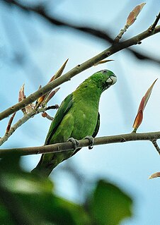
The blue-headed racket-tail, also known as the Palawan racket-tail and locally as kinawihan, is a parrot found in the western Philippines around Palawan. It inhabits humid lowland forest in small flocks. It is threatened by habitat destruction and limited trapping for the cage-bird trade.

The yellow-breasted racket-tail is a species of parrot in the family Psittaculidae. It is endemic to Indonesia where it is found in Sulawesi's northern peninsula and the Togian Islands in the Gulf of Tomini. Its natural habitat is subtropical or tropical moist lowland forests. It is threatened by habitat loss.

Benara, or Mlima Bénara, is the highest peak of Grande-Terre, Mayotte, an overseas collectivity of France in the western Indian Ocean, with a height of 660 m (2,170 ft).
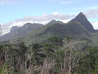
Paitchau is a mountain in the Tutuala subdistrict, Lautém District of East Timor. Situated within Nino Konis Santana National Park, it is south of Lake Ira Lalaro. Though part of a mountain chain, Paitchau is an isolated mountain in the southern Sucos Mehara. It ranges in altitude from 0–960 metres (0–3,150 ft). BirdLife International has classified the mountain and its surrounding region of 55,797 hectares as an Important Bird Area of East Timor. The area contained within the Paitchau Range and Ira Lalaro is sparsely populated and contains several unique faunal and floral species.

The Mlima Combani and Mlima Mtsapéré Important Bird Area lies in the north-central part of the French island territory of Mayotte in the Comoro Islands, lying at the northern end of the Mozambique Channel between the East African country of Mozambique and Madagascar.

Areia Branca beach and hinterland is a 2994 ha Important Bird Area (IBA) in East Timor, a country occupying the eastern end of the island of Timor at the eastern end of the Lesser Sunda Islands group of Wallacea.

Manucoco, also referred to as Gunung Manucoco or Mount Manucoco, is a mountain in the Atauro Island subdistrict of the Dili District of East Timor. It stands near the southern end of Atauro Island, at the western end of Wetar Strait, some 25 km (16 mi) north of Dili, the nation’s capital. The rugged topography of the island’s highlands is a result of the erosion of uplifted, originally submarine, volcanoes from the Neogene period creating narrow, dissected ridges and steep slopes, with Manucoco forming the highest point. The upper levels of the mountain still carry patches of tropical semi-evergreen mountain forest in sheltered valleys, covering about 40 km2 (15 sq mi). The mountain, along with the whole of Atauro Island, has been identified as an Important Bird Area by BirdLife International because it supports populations of several of Timor’s and Wetar's restricted-range native bird species.

Lake Be Malae, also spelt Bemalae, is a 3000 ha lagoon in the district of Bobonaro on the north-west coast of East Timor, a country occupying the eastern end of the island of Timor in the Lesser Sunda Islands of Wallacea.
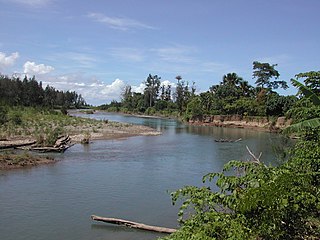
The Irebere estuary and Iliomar forest Important Bird Area is a tract of land in East Timor, a country occupying the eastern end of the island of Timor in the Lesser Sunda Islands of Wallacea.

The Loré Important Bird Area is a 10,906 ha tract of land in East Timor, a country occupying the eastern end of the island of Timor in the Lesser Sunda Islands of Wallacea. It forms the south-westernmost part of the Nino Konis Santana National Park.

The Maubara Important Bird Area is a 5292 ha tract of land in East Timor, a country occupying the eastern end of the island of Timor in the Lesser Sunda Islands of Wallacea.

The Mount Curi Important Bird Area is a 200 km2 tract of land in East Timor, a country occupying the eastern end of the island of Timor in the Lesser Sunda Islands of Wallacea.

Mount Diatuto is a mountain in East Timor, a country occupying the eastern end of the island of Timor in the Lesser Sunda Islands of Wallacea.

The Mount Mak Fahik and Mount Sarim Important Bird Area is a tract of mountainous land in East Timor, a country occupying the eastern end of the island of Timor in the Lesser Sunda Islands of Wallacea.

The Sungai Clere Important Bird Area, also known as the Sungai Clere Protected Wildlife Area, and in Indonesian as Hutan Metiboat, is a tract of low-lying forest and grassland in East Timor, a country occupying the eastern end of the island of Timor in the Lesser Sunda Islands of Wallacea.

The Tilomar Important Bird Area, also known as Tilomar Forest, is a tract of mainly forested land in East Timor, a country occupying the eastern end of the island of Timor in the Lesser Sunda Islands of Wallacea.

South Soufriere Hills is a 35 ha patch of forest on the island of Montserrat, a British Overseas Territory in the Leeward Islands of the Caribbean Sea. It forms one of the territory’s Important Bird Areas (IBAs).
