Liquiçá District

Last updated

Liquiçá
Likisá
District

Fazenda Algarve -Distrito de Liquica.jpg

Fazenda Algarve in Liquiçá
Flag of Liquica.png
Flag
East Timor Liquica locator map 2003-2015.svg
Map of East Timor highlighting Liquiçá District
Coordinates: 8°41′S125°12′E / 8.683°S 125.200°E / -8.683; 125.200 Coordinates: 8°41′S125°12′E / 8.683°S 125.200°E / -8.683; 125.200
Country Flag of East Timor.svg  East Timor
Capital Liquiçá
Subdistricts Bazartete, Liquiçá, Maubara
Area
  Total 549 km2 (212 sq mi)
Area rank 12th
Population (2015 census)
  Total 71,927
  Rank 8th
  Density 130/km2 (340/sq mi)
  Density rank 3rd
Households (2015 census)
  Total 11,885
  Rank 10th
Time zone TLT (UTC+09:00)
ISO 3166 code TL-LI

Liquiçá (Tetum : Likisá) is one of the districts of East Timor. Its capital is also called Liquiçá.

Tetum language Austronesian language spoken on the island of Timor

Tetum (Portuguese), Tetun, is an Austronesian language spoken on the island of Timor. It is spoken in Belu Regency in Indonesian West Timor, and across the border in East Timor, where it is one of the two official languages. In East Timor Tetun Dili, or Tetun Prasa, is widely spoken fluently as a second language; without previous contact, the Tetum dialects and Tetun Dili are not immediately mutually intelligible, mainly because of the large number of Portuguese origin words used in Tetun Dili. Besides some grammatical simplification, Tetun Dili has been greatly influenced by the vocabulary and to a small extent by the grammar of Portuguese, the other official language of East Timor.

East Timor Country in Maritime Southeast Asia

East Timor or Timor-Leste, officially the Democratic Republic of Timor-Leste, is a country in Maritime Southeast Asia. It comprises the eastern half of the island of Timor, the nearby islands of Atauro and Jaco, and Oecusse, an exclave on the northwestern side of the island surrounded by Indonesian West Timor. Australia is the country's southern neighbour, separated by the Timor Sea. The country's size is about 15,410 km2.

Liquiçá Town in Liquiçá District, East Timor

Liquiçá is a coastal city in East Timor, 32 km to the west of Dili, the national capital. Liquiçá is the capital of Liquiçá District. The city has a population of 5,005 inhabitants.

Contents

Geography

Liquiçá District is situated on the northern coast of East Timor, and borders the districts of Dili (containing the national capital) to the east, Aileu to the Southeast, Ermera to the south, and Bobonaro to the southwest. To the northwest lies the Savu Sea. The district has a population of 73,027 (Census 2010) and an area of 549 km². The district is identical to the district of the same name in Portuguese Timor. Its subdistricts are Bazartete, Liquiçá and Maubara.

Ermera Subdistrict and town in Ermera District, East Timor

Ermera is a city in East Timor and a former capital of the East Timorese community, Ermera. Ermera in Mambai language means "red water." It has a population of 8,907. Its geographical coordinates are 8°45′8″S125°23′49″E, and it lies 1,195 metres (3,921 ft) above sea level. Ermera's center lies in the Suco of Poetete.

Savu Sea A small sea within Indonesia between the islands Savu, Rai Jua, Rote, Timor and Sumba

The Savu Sea is a small sea within Indonesia named for the island of Savu (Sawu) on its southern boundary. It is bounded by Savu and Rai Jua to the south, the islands of Rote and Timor to the east, Flores and the Alor archipelago to the north/northwest, and the island of Sumba to the west/northwest. Between these islands, it flows into the Indian Ocean to the south and west, the Flores Sea to the north, and the Banda Sea to the northeast.

Widely known as a beautiful location, it has a breath-taking view of the Ombai Strait, which is most visible as you drive into Liquiçá from Dili, rounding the last mountain curve before descending into the valley. The beaches are rocky, as are most beaches on East Timor, but nonetheless beautiful. The river that flows down to the sea from the mountains is dry, except during the monsoon season. During this time, the main road washes out several times, and is repaired each time by the local population. The only downside to its beauty is the large population of mosquitoes which carry both the deadly diseases malaria and dengue fever.

Ombai Strait strait

The Ombai Strait is the strait which separates the Alor Archipelago from the islands of Wetar, Atauro, and Timor in the Lesser Sunda Islands. Wetar is part of the Maluku Province of Indonesia, the Alor Archipelago and the western part of Timor are part of the province of East Nusa Tenggara, Indonesia, while Atauro and the eastern part of Timor comprise the nation of East Timor. The strait connects the Banda Sea in the north to the Savu Sea to the southwest.

Monsoon seasonal changes in atmospheric circulation and precipitation associated with the asymmetric heating of land and sea

Monsoon is traditionally defined as a seasonal reversing wind accompanied by corresponding changes in precipitation, but is now used to describe seasonal changes in atmospheric circulation and precipitation associated with the asymmetric heating of land and sea. Usually, the term monsoon is used to refer to the rainy phase of a seasonally changing pattern, although technically there is also a dry phase. The term is sometimes incorrectly used for locally heavy but short-term rains, although these rains meet the dictionary definition of monsoon.

Mosquito family of insects

Mosquitoes are a group of about 3500 species of small insects that are a type of fly. Within that order they constitute the family Culicidae. The word "mosquito" is Spanish for "little fly". Mosquitoes have a slender segmented body, a pair of wings, three pairs of long hair-like legs, feathery antennae, and elongated mouthparts.

In addition to the national official languages of Tetum and Portuguese, nearly all of the inhabitants of Liquiçá speak the Malayo-Polynesian language Tocodede.

Portuguese language Romance language that originated in Portugal

Portuguese is a Western Romance language originating in the Iberian Peninsula. It is the sole official language of Portugal, Brazil, Cape Verde, Guinea-Bissau, Mozambique, Angola, and São Tomé and Príncipe. It also has co-official language status in East Timor, Equatorial Guinea and Macau in China. As the result of expansion during colonial times, a cultural presence of Portuguese and Portuguese creole speakers are also found in Goa, Daman and Diu in India; in Batticaloa on the east coast of Sri Lanka; in the Indonesian island of Flores; in the Malacca state of Malaysia; and the ABC islands in the Caribbean where Papiamento is spoken, while Cape Verdean Creole is the most widely spoken Portuguese-based Creole. Reintegrationists maintain that Galician is not a separate language, but a dialect of Portuguese. A Portuguese-speaking person or nation is referred to as "Lusophone" (Lusófono).

History

Fort of Maubara Portuguese Fort, Maubara, East Timor (312835030).jpg
Fort of Maubara

While the Portuguese colonisation of eastern Timor, the Maubara kingdom, in the west of today Liquiçá district, was taken by the Netherlands in 1667, while surrounding territories felt under Portuguese domination. The Maubara Dutch fortification near the beach is well preserved and still has the original cannon that once overlooked the bay. Later, Portugal negotiated with Holland in 1859 and exchanged it for Flores Island in 1861, which was occupied by the Portuguese at that time.

Portugal Republic in Southwestern Europe

Portugal, officially the Portuguese Republic, is a country located mostly on the Iberian Peninsula in southwestern Europe. It is the westernmost sovereign state of mainland Europe, being bordered to the west and south by the Atlantic Ocean and to the north and east by Spain. Its territory also includes the Atlantic archipelagos of the Azores and Madeira, both autonomous regions with their own regional governments.

Maubara is a village in Maubara Subdistrict, just west of the city of Liquiçá. Most of the inhabitants speak Tocodede. It lies near the Maubara Important Bird Area, encompassing the small coastal Lake Maubara.

Netherlands Constituent country of the Kingdom of the Netherlands in Europe

The Netherlands is a country located mainly in Northwestern Europe. The European portion of the Netherlands consists of twelve separate provinces that border Germany to the east, Belgium to the south, and the North Sea to the northwest, with maritime borders in the North Sea with Belgium, Germany and the United Kingdom. Together with three island territories in the Caribbean Sea—Bonaire, Sint Eustatius and Saba— it forms a constituent country of the Kingdom of the Netherlands. The official language is Dutch, but a secondary official language in the province of Friesland is West Frisian.

During the Indonesian occupation, the Indonesian government did construct many buildings in Liquiçá, but after the referendum of 1999 and during the militia`s campaign almost everything was destroyed. Most notably, many East Timorese were murdered during the Liquiçá Church Massacre of April 1999. Maubara is the location where the dreaded militia group Besi Merah Putih was first formed. [1] In September 1999 an American police officer serving with the International Police was shot (though not fatally) by pro-Indonesian forces while the UN was evacuating Liquiçá. [1]

From September through November 1999, life came back to Liquiçá, as UN Peace Keeping Forces from Portugal set up a base in Maubara, and the International Police set up its headquarters in downtown Liquiçá. Originally, there were 14 International Police assigned to Liquiçá, representing Sweden, Canada, Great Britain, Ghana, Malaysia, and the United States. It was in Liquiçá that the first International Police officer for the East Timor mission died, as a result of contracting dengue fever; he was from Ghana. During this period, the International Police occupied the very same church compound location where the Liquiçá Church Massacre had played out. The peacekeeper military element for Liquiçá were Portuguese Marines. Liquica was also the main base of operations for the UNTAET Crime Scene Detachment.

Buildings

During the Portuguese occupation, there were very few buildings other than the traditional huts used by local East Timorese. Most of the buildings were constructed during the Indonesian occupation, but most of them were destroyed during the militia riots and violent onslaughts following and leading up to the referendum in 1999. Some of the buildings that still remain intact are the Portuguese buildings. Many of the Indonesian buildings were repairable. The construction and design is a traditional Indonesian style, which is both out dated, yet artistic and creative.

Subdivisions of Liquica Sucos Liquica.png
Subdivisions of Liquiçá
Cities of Liquica Liquica subdistricts.png
Cities of Liquiçá

Resources

Fusilier fish in Maubara 30-EastTimor-Dive2 Maubara 26 (Fusiliers)-APiazza.JPG
Fusilier fish in Maubara

Liquiçá has beautiful beaches (although no white sands) that are very attractive for tourism. Liquiçá also has coffee plantations and some minerals such as gold. Several diving spots scatter along the coast.

Related Research Articles

Díli City in Dili, East Timor

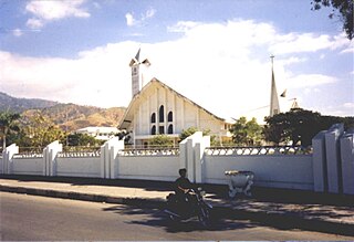
Dili, also known as “City of Peace”, is the capital, largest city, chief port, and commercial centre of East Timor (Timor-Leste). Dili is part of a free trade zone, the Timor Leste–Indonesia–Australia Growth Triangle (TIA-GT).

History of East Timor aspect of history

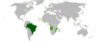
East Timor is a country in Southeast Asia, officially known as Democratic Republic of Timor-Leste. The country comprises the eastern half of the island of Timor and the nearby islands of Atauro and Jaco. The first inhabitants are thought to be descendant of Australoid and Melanesian peoples. The Portuguese began to trade with Timor by the early 16th century and colonised it throughout the mid-century. Skirmishing with the Dutch in the region eventually resulted in an 1859 treaty for which Portugal ceded the western half of the island. Imperial Japan occupied East Timor during World War II, but Portugal resumed colonial authority after the Japanese surrender.

Baucau Municipality Municipality in East Timor

Baucau is a municipality, and was formerly a district, of East Timor, on the northern coast in the eastern part of the country. The capital is also called Baucau. The population of the municipality is 111,694 and it has an area of 1,506 km².

Bobonaro Municipality Municipality in East Timor

Bobonaro Municipality is a municipality in the Democratic Republic of Timor-Leste commonly known as East Timor. It is the second-most western municipality on the east half of the island. It has a population of 92,045 and an area of 1,376 km².

National University of East Timor university

The National University of East Timor, based in the East Timorese capital Dili, is the major institution of higher education in East Timor.

Ermera Municipality Municipality in East Timor


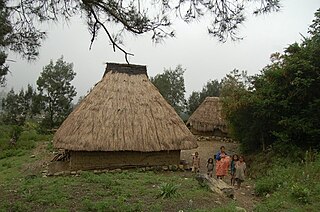
Ermera is one of the municipalities of East Timor, located in the west-central part of the country. It has a population of 117,064 and an area of 746 km².

The Liquiçá Church massacre was a mass-killing that occurred in April 1999, during East Timor's bid for independence. It was the first case to be heard by the Second Special Panel.

Besi Merah Putih, meaning 'red and white iron' in Indonesian, is the official name of a pro-Indonesia militia operating in the district of Liquiçá, and originating in the village of Maubara.

The Manuel Carrascalão House massacre occurred on 17 April 1999 in Dili, East Timor, at the house of East Timorese independence leader Manuel Carrascalão. 12 people were killed by the pro-Indonesia Aitarak militia, commanded by Eurico Guterres, including Carrascalão's 17-year-old son Manelito, who was tortured and hacked to death. The bodies of the victims were transported to the village of Maubara, the headquarters of the Besi Merah Putih militia, where they were buried, in coffins, with personal possessions and identification. The bodies were exhumed in 2000, by the UNTAET Crime Scene Detachment.

Aitarak anti-independence militia in East Timor, active from 1999 to 2000

Aitarak was the name of one of the most feared pro-Indonesia militia groups in East Timor during the late 1990s. On April 17, 1999, the group conducted 12 murders at the Manuel Carrascalão House massacre in Dili. That same month members took part in the Liquiçá Church massacre. At its height, the group was led by Eurico Guterres.

Manuel Viegas Carrascalão was an Indonesian parliamentarian and prominent East Timorese independence leader. The Carrascalão family is of mestiço ancestry; Carrascalao was born on Atauro Island.

Dili Municipality Municipality in East Timor

Dili is one of the 13 municipalities, formerly districts, of Timor-Leste, which includes the national capital Dili. It had a population of 277,279 as of 2015, most of whom live in the capital city. The municipality has an area of 368.12 km2 (142.13 sq mi). The municipality continued the same name as the council had in Portuguese Timor.

Maliana City in Bobonaro, East Timor

Maliana is a city in East Timor, 149 km southwest of Dili, the national capital. It has a population of 22,000. It is the capital of the district of Bobonaro and Maliana Subdistrict, and is located just a few kilometers from the border with Indonesia. It is also the see city of the Roman Catholic Diocese of Maliana, which was formed by Pope Benedict XVI with territory taken from the Roman Catholic Diocese of Dili.

Casa Europa

Casa Europa is an historic late nineteenth-century Portuguese colonial building in the Bidau Lecidere suco of Dili, capital city of East Timor. Initially a Portuguese Quartel de Infantaria, it became the home of the municipality of Dili administration in the late 1930s. Following the Japanese occupation of Portuguese Timor, it reverted to being a Portuguese military facility until 1972, and was later taken over by the Indonesian military. Now the oldest building in the city centre, it has since been renovated and given its present name, and presently houses European diplomatic representatives.

Ai Pelo Prison

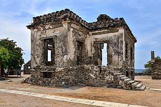
Ai Pelo Prison or Aipelo Prison is an historic late nineteenth-century Portuguese colonial prison in the Lauhata suco, East Timor, adjacent to the Savu Sea. It was deactivated in 1939 and is now a ruin.

Banco Nacional Ultramarino building, Dili Portuguese bank building in Dili, East Timor

The Banco Nacional Ultramarino (BNU) building in the centre of Dili, capital city of East Timor, is a modernist structure unusual in Timor. Constructed between 1966 and 1968, it has only one contemporary, the headquarters of the Timor Commercial, Agricultural and Industrial Association. As a consequence of political turbulence culminating in the Indonesian invasion of East Timor in 1975, the BNU closed down its Timor operations. However, since 2001 the building has again been occupied by BNU Timor, now a trading name of the Portuguese bank Caixa Geral de Depósitos.

References

  1. 1 2 "Source". 28 May 2006. Archived from the original on 28 May 2006.