Ainaro District

Last updated

Ainaro
Ainaru
District

Maubisse 14-7.jpg

Maubisse village
Flag of Ainaro.svg
Flag
East Timor Ainaro locator map 2003-2015.svg
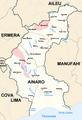
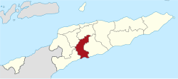
Map of East Timor highlighting Ainaro District
Coordinates: 9°05′S125°29′E / 9.083°S 125.483°E / -9.083; 125.483 Coordinates: 9°05′S125°29′E / 9.083°S 125.483°E / -9.083; 125.483
Country Flag of East Timor.svg  East Timor
Capital Ainaro
Subdistricts Ainaro, Hato-Udo, Hatu-Builico, Maubisse
Area
  Total 804 km2 (310 sq mi)
Area rank 9th
Population (2015 census)
  Total 63,136
  Rank 10th
  Density 79/km2 (200/sq mi)
  Density rank 6th
Households (2015 census)
  Total 10,601
  Rank 9th
Time zone TLT (UTC+09:00)
ISO 3166 code TL-AN

Ainaro is one of 13 administrative districts of East Timor, in the southwest part of the country. It has a population of 59,175 (census 2010) and an area of 804 km². [1] Its capital is the city of Ainaro, a small mountain town.

East Timor Country in Maritime Southeast Asia

East Timor or Timor-Leste, officially the Democratic Republic of Timor-Leste, is a country in Maritime Southeast Asia. It comprises the eastern half of the island of Timor, the nearby islands of Atauro and Jaco, and Oecusse, an exclave on the northwestern side of the island surrounded by Indonesian West Timor. Australia is the country's southern neighbour, separated by the Timor Sea. The country's size is about 15,410 km2.

Ainaro Town in East Timor

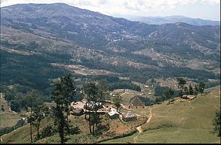
Ainaro is a town in East Timor, the capital of the Ainaro Municipality, and is located in the southwest part of the country. The Ainaro Subdistrict has a population of approximately 14,130 people (2001). It contains the small mountain town of Ainaro, the district capital, along with the sucos of Soro, Maununo, Cassa, Suro Craic, Manutassi, and Mau-Ulo. The town of Ainaro is located 78 km south of Dili, the national capital.

Contents

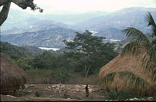
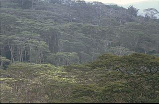
Ainaro has a great abundance of rivers and fertile terrain for agriculture. It has a coastal area, on the Timor Sea, but also mountainous zones, including the highest point in East Timor, Mount Ramelau (2,960 m), also known as Tatamailau, which lies near the border with Ermera. Historically, Ainaro played an important role during the brutal Indonesian occupation of East Timor, providing shelter for the mountain-based guerrilla resistance army. Former guerrilla leader and current President Xanana Gusmão spent many years directing the resistance from Ainaro.

Timor Sea A sea bounded to the north by the island of Timor, to the east by the Arafura Sea, to the south by Australia

The Timor Sea is a relatively shallow sea bounded to the north by the island of Timor, to the east by the Arafura Sea, to the south by Australia.

Ermera Subdistrict and town in Ermera District, East Timor

Ermera is a city in East Timor and a former capital of the East Timorese community, Ermera. Ermera in Mambai language means "red water." It has a population of 8,907. Its geographical coordinates are 8°45′8″S125°23′49″E, and it lies 1,195 metres (3,921 ft) above sea level. Ermera's center lies in the Suco of Poetete.

Indonesia Republic in Southeast Asia

Indonesia, officially the Republic of Indonesia, is a country in Southeast Asia, between the Indian and Pacific oceans. It is the world's largest island country, with more than seventeen thousand islands, and at 1,904,569 square kilometres, the 14th largest by land area and the 7th largest in combined sea and land area. With over 261 million people, it is the world's 4th most populous country as well as the most populous Muslim-majority country. Java, the world's most populous island, contains more than half of the country's population.

Geography

The district is identical to that of the same in Portuguese Timor, with the following exceptions: during the Indonesian occupation, the subdistrict of Turiscai became part of Manufahi District from Ainaro, and the subdistrict of Hato-Udo became part of Ainaro in exchange. The subdistrict of Mape-Zumalai became part of Cova Lima District in 2003.

Portuguese Timor Name of the Portuguese colony, now known as East Timor (Timor-Leste), an independent country

Portuguese Timor refers to East Timor during the historic period when it was a Portuguese colony that existed between 1702 and 1975. During most of this period, Portugal shared the island of Timor with the Dutch East Indies.

The district borders Aileu District to the north, Manufahi District to the south, Cova Lima District to the southwest, Bobonaro District to the west, and Ermera District to the northwest.

Demographics

Languages

In addition to the official languages of Tetum and Portuguese, a large number of inhabitants of Ainaro speak the Malayo-Polynesian language Mambai.

Religion

The inhabitants include catholics, protestants, and muslims living side by side.

Administrative divisions

Related Research Articles

Municipalities of East Timor

East Timor is divided into 13 municipalities, one of which is also a Special Administrative Region. The municipalities are divided into administrative posts, and further subdivided into sucos.

Baucau Municipality Municipality in East Timor

Baucau is a municipality, and was formerly a district, of East Timor, on the northern coast in the eastern part of the country. The capital is also called Baucau. The population of the municipality is 111,694 and it has an area of 1,506 km².

Bobonaro Municipality Municipality in East Timor

Bobonaro Municipality is a municipality in the Democratic Republic of Timor-Leste commonly known as East Timor. It is the second-most western municipality on the east half of the island. It has a population of 92,045 and an area of 1,376 km².

Aileu Municipality Municipality in East Timor

Aileu is a municipality, and was formerly a district, of East Timor. It has a population of 48,554 and an area of 737 km². The municipality's capital is also named Aileu. Its administrative posts are Aileu, Laulara, Lequidoe and Remexio.

Liquiçá Municipality Municipality in East Timor

Liquiçá is one of the municipalities of East Timor. Its capital is also called Liquiçá.

Lautém Municipality Municipality in East Timor

Lautém is one of the municipalities of East Timor, on the eastern end of the island of Timor. It has a population of 64,135 and an area of 1,813 km². Its capital is Lospalos, which lies 248 km east of the national capital, Dili.

Manatuto Municipality Municipality in East Timor

Manatuto is one of the municipalities of East Timor, located in the central part of the country. It has a population of 45,541 and an area of 1,78 km². The capital of the municipality is also named Manatuto.

Viqueque Municipality Municipality in East Timor

Viqueque is the largest of the municipalities of East Timor. It has a population of 77,402 and an area of 1,877 km². The capital of the municipality is also named Viqueque.

Manufahi Municipality Municipality in East Timor

Manufahi is one of the municipalities of East Timor. It has a population of 53,691 and an area of 1,323 km². The capital of the municipality is Same.

Ermera Municipality Municipality in East Timor


Ermera is one of the municipalities of East Timor, located in the west-central part of the country. It has a population of 117,064 and an area of 746 km².

Cova Lima Municipality Municipality in East Timor

Cova Lima is a municipality of East Timor, in the Southwest part of the country. It has a population of 59,455 and an area of 1,230 km². The capital of the municipality is Suai, which lies 136 km from Dili, the national capital. The administrative posts of Cova Lima are Fatululic, Fatumean, Fohorem, Zumalai, Maucatar, Suai, and Tilomar.

Same, East Timor Town in Manufahi, East Timor

Same is a city in the Same Subdistrict in the interior of East Timor, 81 kilometres (50 mi) south of Dili, the national capital. Same has a population of 7,413 and is the capital of Manufahi District, which was known as Same District in Portuguese Timor.

Bunak people

The Bunak people are an ethnic group that live in the mountainous region of central Timor, split between the political boundary between West Timor, Indonesia, particularly in Lamaknen District and East Timor. Their language, Bunak language, is one of the few on Timor which is not an Austronesian language, but rather a Papuan language like groups on New Guinea. It is usually put in the proposed language group Trans–New Guinea. They are surrounded by groups which speak Malayo-Polynesian languages, like the Atoni and the Tetum.

Kemak people

The Kemak people are an ethnic group numbering 80,000 in north-central Timor island. They primarily live in the district of Bobonaro, East Timor, while the rest live in the East Nusa Tenggara province of Indonesia.

Tatamailau mountain in East Timor

Tatamailau, or Tata Mailau, sometimes referred as Mount Ramelau, is the highest mountain in East Timor and also of Timor island at 2,986 m (9,797 ft). The mountain is located approximately 70 km (43 mi) south of the capital Dili in the district of Ainaro. While East Timor was a Portuguese colony it was called the highest mountain of Portugal in the twentieth century, since the highest mountain of Portugal proper is of a more modest height. The name "Tatamailau" is Mambai-origin, the local language and means "Grandfather of all". "Ramelau" is the name of the massif of the mountain. The Tatamailau is dedicated to the Virgin Mary and the subject of an annual pilgrimage commemorating the Annunciation of the Blessed Virgin Mary, on or around 25 March. There is a three metre high statue of the Virgin Mary on the peak, which came from Italy and was erected during Indonesian occupation in 1997.

Subdivisions of East Timor

East Timor is divided into:

Taça Digicel

Taça Digicel was a football championship organized by the East Timor Football Federation. It was replaced by Taça 12 de Novembro in 2013.

Mambai people (Timor) ethnic group in East Timor

The Mambai people are the second largest ethnic group after the Tetum Dili people in East Timor. Originally, they were known as the Maubere by the Portuguese. Maubere or Mau Bere is a widespread male first name among the Mambai people.

References

  1. "Rezumu hosi Rezultadu Prinsipál Sensu 2010 iha Timor-Leste" (PDF). La'o Hamutuk. 2011. Retrieved 2017-02-22.