This article may be expanded with text translated from the corresponding article in German. (July 2011)Click [show] for important translation instructions.
|
This article needs additional citations for verification . (February 2017) (Learn how and when to remove this template message) |
Manufahi | ||
---|---|---|
District | ||
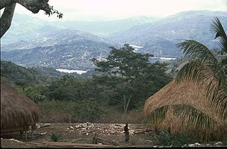
Landscape between Dili and Same | ||
| ||
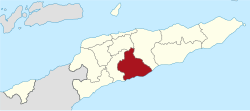
Map of East Timor highlighting Manufahi District | ||
Coordinates: 9°00′S125°47′E / 9.000°S 125.783°E Coordinates: 9°00′S125°47′E / 9.000°S 125.783°E | ||
Country | ||
Capital | Same | |
Subdistricts | Alas, Fatuberlio, Same, Turiscai | |
Area | ||
• Total | 1,323 km2 (511 sq mi) | |
Area rank | 6th | |
Population (2015 census) | ||
• Total | 53,691 | |
• Rank | 11th | |
• Density | 41/km2 (110/sq mi) | |
• Density rank | 11th | |
Households (2015 census) | ||
• Total | 9,023 | |
• Rank | 11th | |
Time zone | TLT (UTC+09:00) | |
ISO 3166 code | TL-MF |
Manufahi is one of the districts of East Timor. It has a population of 53,691 (2015 census) and an area of 1,323 km². [1] The capital of the district is Same. [2] The subdistricts are Alas, Fatuberlio, Same, and Turiscai.
During its time as a Portuguese colony, the district was called Same, after the capital city. It was the epicentre of the Great Rebellion of 1910–12. During the Indonesian occupation the subdistrict Hato-Udo was split off from the district and joined to Ainaro, and the subdistrict Turiscai, previously in Ainaro, was moved to Manufahi.
Portugal, officially the Portuguese Republic, is a country located mostly on the Iberian Peninsula in southwestern Europe. It is the westernmost sovereign state of mainland Europe, being bordered to the west and south by the Atlantic Ocean and to the north and east by Spain. Its territory also includes the Atlantic archipelagos of the Azores and Madeira, both autonomous regions with their own regional governments.
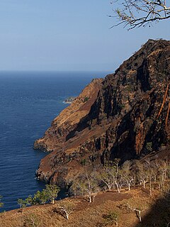
Manufahi lies on the south coast of East Timor, on the Timor Sea. It borders Manatuto District to the east, Ainaro District to the west, and Aileu District to the north.
The Timor Sea is a relatively shallow sea bounded to the north by the island of Timor, to the east by the Arafura Sea, to the south by Australia.
Besides the national official languages of Tetum and Portuguese, the Malayo-Polynesian language Mambai is also spoken.
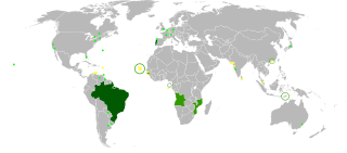
Portuguese is a Western Romance language originating in the Iberian Peninsula. It is the sole official language of Portugal, Brazil, Cape Verde, Guinea-Bissau, Mozambique, Angola, and São Tomé and Príncipe. It also has co-official language status in East Timor, Equatorial Guinea and Macau in China. As the result of expansion during colonial times, a cultural presence of Portuguese and Portuguese creole speakers are also found in Goa, Daman and Diu in India; in Batticaloa on the east coast of Sri Lanka; in the Indonesian island of Flores; in the Malacca state of Malaysia; and the ABC islands in the Caribbean where Papiamento is spoken, while Cape Verdean Creole is the most widely spoken Portuguese-based Creole. Reintegrationists maintain that Galician is not a separate language, but a dialect of Portuguese. A Portuguese-speaking person or nation is referred to as "Lusophone" (Lusófono).
The Mambai people are the second largest ethnic group after the Tetum Dili people in East Timor. Originally, they were known as the Maubere by the Portuguese. Maubere or Mau Bere is a widespread male first name among the Mambai people.
Baucau is a municipality, and was formerly a district, of East Timor, on the northern coast in the eastern part of the country. The capital is also called Baucau. The population of the municipality is 111,694 and it has an area of 1,506 km².
Bobonaro Municipality is a municipality in the Democratic Republic of Timor-Leste commonly known as East Timor. It is the second-most western municipality on the east half of the island. It has a population of 92,045 and an area of 1,376 km².
Aileu is a municipality, and was formerly a district, of East Timor. It has a population of 48,554 and an area of 737 km². The municipality's capital is also named Aileu. Its administrative posts are Aileu, Laulara, Lequidoe and Remexio.
Liquiçá is one of the municipalities of East Timor. Its capital is also called Liquiçá.
Lautém is one of the municipalities of East Timor, on the eastern end of the island of Timor. It has a population of 64,135 and an area of 1,813 km². Its capital is Lospalos, which lies 248 km east of the national capital, Dili.
Manatuto is one of the municipalities of East Timor, located in the central part of the country. It has a population of 45,541 and an area of 1,78 km². The capital of the municipality is also named Manatuto.
Viqueque is the largest of the municipalities of East Timor. It has a population of 77,402 and an area of 1,877 km². The capital of the municipality is also named Viqueque.
Ermera is one of the municipalities of East Timor, located in the west-central part of the country. It has a population of 117,064 and an area of 746 km².
Cova Lima is a municipality of East Timor, in the Southwest part of the country. It has a population of 59,455 and an area of 1,230 km². The capital of the municipality is Suai, which lies 136 km from Dili, the national capital. The administrative posts of Cova Lima are Fatululic, Fatumean, Fohorem, Zumalai, Maucatar, Suai, and Tilomar.
Same is a city in the Same Subdistrict in the interior of East Timor, 81 kilometres (50 mi) south of Dili, the national capital. Same has a population of 7,413 and is the capital of Manufahi District, which was known as Same District in Portuguese Timor.
Dili is one of the 13 municipalities, formerly districts, of Timor-Leste, which includes the national capital Dili. It had a population of 277,279 as of 2015, most of whom live in the capital city. The municipality has an area of 368.12 km2 (142.13 sq mi). The municipality continued the same name as the council had in Portuguese Timor.
Ainaro is one of 13 municipalities of East Timor, in the southwest part of the country. It has a population of 59,175 and an area of 804 km². Its capital is the city of Ainaro, a small mountain town.
Lospalos is a city in East Timor, 248 kilometres (154 mi) to the east of Dili, the national capital. Lospalos has a population of 17,186 (2006) and is the capital of Lautém District and the Lospalos Subdistrict. The subdistrict has a population of 25,417 (2004).
The Bunak people are an ethnic group that live in the mountainous region of central Timor, split between the political boundary between West Timor, Indonesia, particularly in Lamaknen District and East Timor. Their language is one of the few on Timor which is not an Austronesian language, but rather a Papuan language, belonging to the Trans–New Guinea linguistic family. They are surrounded by groups which speak Malayo-Polynesian languages, like the Atoni and the Tetum.
Oecusse, also variously Oecussi, Ocussi, Oekussi, Oekusi, Okusi, Oé-Cusse, and formerly Ambeno and Oecussi-Ambeno, is both a municipality and a Special Administrative Region (SAR), and was formerly a district, of East Timor.
Aleixo Corte-Real, better known under the name of Dom Aleixo Timorese, was a hero during World War II.
This East Timor location article is a stub. You can help Wikipedia by expanding it. |