This article may be expanded with text translated from the corresponding article in German. (July 2011)Click [show] for important translation instructions.
|
| Manatuto Manatutu | ||
|---|---|---|
| District | ||
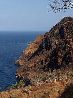
Cliffs at Manatuto | ||
| ||
 Map of East Timor highlighting Manatuto District | ||
| Coordinates: 8°42′S125°55′E / 8.700°S 125.917°E Coordinates: 8°42′S125°55′E / 8.700°S 125.917°E | ||
| Country | ||
| Capital | Manatuto | |
| Subdistricts | Barique-Natarbora, Laclo, Laclubar, Laleia, Manatuto, Soibada | |
| Area | ||
| • Total | 1,782 km2 (688 sq mi) | |
| Area rank | 2nd | |
| Population (2015 census) | ||
| • Total | 46,619 | |
| • Rank | 13th | |
| • Density | 26/km2 (68/sq mi) | |
| • Density rank | 13th | |
| Households (2015 census) | ||
| • Total | 7,467 | |
| • Rank | 12th | |
| Time zone | TLT (UTC+09:00) | |
| ISO 3166 code | TL-MT | |

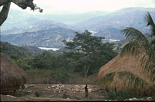
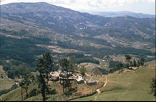
Manatuto is one of the districts of East Timor, located in the central part of the country. It reaches both the south and north coasts of the island, and is only one of two districts to do so (the other is Lautém in the far east). To the north is the Strait of Wetar, to the south is the Timor Sea. The district borders the districts of Baucau and Viqueque to the east and Manufahi, Aileu, and Dili to the west. The district of Manatuto is the only district other than Lautém that touches both the north and south coast, and has the most geographical diversity.

East Timor or Timor-Leste, officially the Democratic Republic of Timor-Leste, is a country in Maritime Southeast Asia. It comprises the eastern half of the island of Timor, the nearby islands of Atauro and Jaco, and Oecusse, an exclave on the northwestern side of the island surrounded by Indonesian West Timor. Australia is the country's southern neighbour, separated by the Timor Sea. The country's size is about 15,410 km2.

The Timor Sea is a relatively shallow sea bounded to the north by the island of Timor, to the east by the Arafura Sea, to the south by Australia.
It has a population of 45,541 (Census 2010) and an area of 1,78 km². The capital of the district is also named Manatuto.

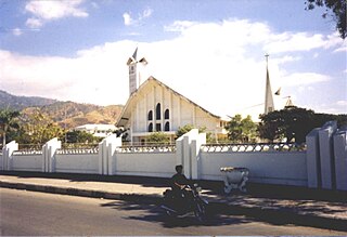
Manatuto is a city of Manatuto District, East Timor.
The district of Manatuto is identical to the council of Portuguese Timor with the same name. It has the subdistricts Barique-Natarbora (pop. 4,900), Laclo (pop. 6,400), Laclubar (pop. 10,100), Laleia (pop. 3,200), Manatuto (pop. 11,500), and Soibada (pop. 2,950). The district is known as the birthplace of Xanana Gusmão, later to become the nation's first president and now the prime minister. He was born in the village of Laleia (19 km East of Manatuto town).

Portuguese Timor refers to East Timor during the historic period when it was a Portuguese colony that existed between 1702 and 1975. During most of this period, Portugal shared the island of Timor with the Dutch East Indies.

Kay Rala Xanana Gusmão, GColIH, GCL, GCMG is an East Timorese politician. A former militant, he was the first President of East Timor, serving from May 2002 to May 2007. He then became the fourth Prime Minister of East Timor, serving from 8 August 2007 to 16 February 2015. He has been Minister of Planning and Strategic Investment since February 2015.
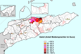
In addition to the official languages of East Timor (Tetum and Portuguese), a large part of the population of the district speaks the Malayo-Polynesian language Galoli, which is designated as a "national language" by the constitution.
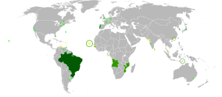
Portuguese is a Western Romance language originating in the Iberian Peninsula. It is the sole official language of Portugal, Brazil, Cape Verde, Guinea-Bissau, Mozambique, Angola, and São Tomé and Príncipe. It also has co-official language status in East Timor, Equatorial Guinea and Macau in China. As the result of expansion during colonial times, a cultural presence of Portuguese and Portuguese creole speakers are also found in Goa, Daman and Diu in India; in Batticaloa on the east coast of Sri Lanka; in the Indonesian island of Flores; in the Malacca state of Malaysia; and the ABC islands in the Caribbean where Papiamento is spoken, while Cape Verdean Creole is the most widely spoken Portuguese-based Creole. Reintegrationists maintain that Galician is not a separate language, but a dialect of Portuguese. A Portuguese-speaking person or nation is referred to as "Lusophone" (Lusófono).
 |  |