This article may be expanded with text translated from the corresponding article in German. (March 2011)Click [show] for important translation instructions.
View a machine-translated version of the German article.
Google's machine translation is a useful starting point for translations, but translators must revise errors as necessary and confirm that the translation is accurate, rather than simply copy-pasting machine-translated text into the English Wikipedia.
Do not translate text that appears unreliable or low-quality. If possible, verify the text with references provided in the foreign-language article.
You must provide copyright attribution in the edit summary by providing an interlanguage link to the source of your translation. A model attribution edit summary (using German): Content in this edit is translated from the existing German Wikipedia article at [[:de:Exact name of German article]]; see its history for attribution.
You should also add the template {{Translated|de|Oecusse (Distrikt)}} to the talk page.
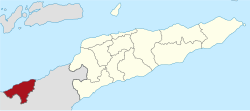
Oecusse (Tetum: Oekusi-Ambenu, also variously Oecussi, Ocussi, Oekussi, Oekusi, Okusi, Oé-Cusse), formerly Ambeno and Oecussi-Ambeno, is a district of East Timor. It is a coastal exclave in the western part of the island of Timor, separated from the rest of East Timor by West Timor, which is part of the province of Nusa Tenggara Timur, Indonesia, and which surrounds Oecusse in all directions except the north, where it borders the Savu Sea. The capital of the district is Pante Macassar, also called Oecussi Town, or formerly, in Portuguese Timor, Vila Taveiro. Originally Ambeno was the name of the district and Oecussi (< Oe Kusi) its capital.[1]
Tetum (Portuguese), Tetun, is an Austronesian language spoken on the island of Timor. It is spoken in Belu Regency in Indonesian West Timor, and across the border in East Timor, where it is one of the two official languages. In East Timor Tetun Dili, or Tetun Prasa, is widely spoken fluently as a second language; without previous contact, the Tetum dialects and Tetun Dili are not immediately mutually intelligible, mainly because of the large number of Portuguese origin words used in Tetun Dili. Besides some grammatical simplification, Tetun Dili has been greatly influenced by the vocabulary and to a small extent by the grammar of Portuguese, the other official language of East Timor.
East Timor or Timor-Leste, officially the Democratic Republic of Timor-Leste, is a country in Maritime Southeast Asia. It comprises the eastern half of the island of Timor, the nearby islands of Atauro and Jaco, and Oecusse, an exclave on the northwestern side of the island surrounded by Indonesian West Timor. Australia is the country's southern neighbour, separated by the Timor Sea. The country's size is about 15,410 km2.
Timor is an island at the southern end of Maritime Southeast Asia, north of the Timor Sea. The island is divided between the sovereign states of East Timor on the eastern part and Indonesia on the western part. The Indonesian part, also known as West Timor, constitutes part of the province of East Nusa Tenggara. Within West Timor lies an exclave of East Timor called Oecusse District. The island covers an area of 30,777 square kilometres. The name is a variant of timur, Malay for "east"; it is so called because it lies at the eastern end of the Lesser Sunda Islands. Mainland Australia is less than 500 km away, separated by the mentioned Timor Sea.
The district has an area of 814 square kilometres (314sqmi).
History
Oecusse and Ambeno are the names of the two original kingdoms, of which Ambeno existed before the colonial period.
The Ambeno was a traditional kingship on the north coast of Timor, among the Atoni people. Its area is now in the Oecusse district of East Timor. The capital was in Nunheno until 1912, then in Tulaica.
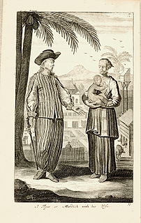
Oecusse was among the first parts of the island of Timor on which the Portuguese established themselves, and is thus usually considered the cradle of East Timor. In about 1556, the Dominican friar António Taveiro, operating from a base on Solor, started missionary work on the north coast of Timor. Shortly after this, in 1569, the village of "Alifao" (Lifau) is mentioned on a European map. It was situated five kilometres to the west of modern Pante Macassar.[2] For the Portuguese traders in sandalwood, Lifau was a convenient place to land since it was situated to the south of their base in the Solor Archipelago. The area was dominated by the Ambeno kingdom, which was sometimes referred as the kingdom of Lifau. In 1641 the Dominican priests baptised the royal families of the Ambeno, Mena and Amanuban kingdoms, which meant that Portuguese influence increased in parts of western Timor. Migration of Topasses, a Eurasian population, rose in the 1650s from Larantuka on Flores. After 1664 they were governed by officers belonging to the Hornay and Da Costa families, and were able to dominate most of Timor. The Topass leaders used Lifau as their main stronghold on Timor, but still resided much of their time in Larantuka. In the second half of the seventeenth century they made great profits through the sandalwood trade, attracting merchants from Siam, Batavia, Macao, and Goa in India. The precious wood was brought to Lifau and sold to external traders under Topass supervision.[3]
The Portuguese Empire, also known as the Portuguese Overseas or the Portuguese Colonial Empire, was one of the largest and longest-lived empires in world history. It existed for almost six centuries, from the capture of Ceuta in 1415, to the handover of Portuguese Macau to China in 1999. The empire began in the 15th century, and from the early 16th century it stretched across the globe, with bases in North and South America, Africa, and various regions of Asia and Oceania. The Portuguese Empire has been described as the first global empire in history, a description also given to the Spanish Empire.
Solor is a volcanic island located off the eastern tip of Flores island in the Lesser Sunda Islands of Indonesia, in the Solor Archipelago. The island supports a small population that has been whaling for hundreds of years. They speak the languages of Adonara and Lamaholot. There are at least five volcanoes on this island which measures only 40 kilometres by 6 kilometres. The island's area is 222 square kilometres.
Lifau is a village and suco in the East Timor exclave of Oecusse District. The village is located west of the mouth of the Tono River. 1,938 people live in the suco.
In 1702, Lifau became the authorised capital of the colony when it received the first governor from Goa. The following period saw frequent clashes between the governor and the independent-minded Topasses, who had their strongholds in Tulicão west of Lifau, and Animata in the inland. Under their leader Gaspar da Costa they attacked the Dutch colonial post at Kupang in 1749 but were smashingly defeated, and subsequently moved their residence to Pante Macassar (Oecusse) in 1759 due to Dutch military pressure. The capital of the governor was transferred from Lifau to Dili in 1769, because of the frequent attacks from the Topass leader Francisco Hornay III. Most of West Timor was left to Dutch forces, who were conquering what is today Indonesia. The Eurasian leadership of Oecusse by and by turned into a Timorese kingship, and members of the Hornay and Da Costa families reigned as Liurai (kings) until modern times. They regularly intermarried with the Ambeno royalty. In the 1780s a reconciliation took place between the governor in Dili and the Topasses, who henceforth usually supported the Portuguese government.[4]
Goa is a state on the southwestern coast of India within the region known as the Konkan, separated from the Deccan highlands of the state of Karnataka by the Western Ghats. It is bounded by Maharashtra to the north and Karnataka to the east and south, with the Arabian Sea forming its western coast. It is India's smallest state by area and the fourth-smallest by population. Goa has the highest GDP per capita among all Indian states, two and a half times that of the country. It was ranked the best-placed state by the Eleventh Finance Commission for its infrastructure and ranked on top for the best quality of life in India by the National Commission on Population based on the 12 Indicators.
Gaspar da Costa was the leader or tenente geral of the Portuguese-speaking Topasses, a Eurasian group that dominated much of the politics on Timor in the early modern period. He was largely responsible for the dramatic collapse of Portuguese power in West Timor, a process that laid the foundations for the modern division of Timor in an Indonesian and an independent part.
Kupang is the capital of the Indonesian province of East Nusa Tenggara, and has an estimated population in 2011 of 349,344. It is the biggest city and port on the island of Timor. Kupang is a part of the Timor Leste–Indonesia–Australia Growth Triangle free trade zone.
In 1859, with the Treaty of Lisbon, Portugal and the Netherlands divided the island between them. West Timor became Dutch, with its colonial seat at Kupang, and East Timor became Portuguese, with its seat in Dili. This left Oecusse and Noimuti as enclaves surrounded by Dutch territory. In 1912 the Liurai of Ambeno, João da Cruz, staged a revolt against the Portuguese. It was quickly put down, after which the Ambeno kingdom lapsed. The Liurai of Oecusse became dominant in the entire Oecusse exclave.[5] The definitive border was drawn by the Hague in 1916. Apart from Japanese occupation during World War II, the border remained the same until the end of the colonial period. The region was given the status of county (conselho), named Oecússi, by the Portuguese government in August 1973, the last Timorese area to receive it.
The Treaty of Lisbon of 1859 is a treaty signed between Portugal and the Netherlands on April 20, 1859. The treaty fixed the border between the Portuguese and the Dutch colonies in the Indonesian Archipelago, between Portuguese Timor and the Dutch East Indies. Pedro V of Portugal was represented by António Maria de Fontes Pereira de Melo while William III of the Netherlands was represented by Maurits Jan Heldewier, Chargé d'affaires of the Netherlands.
Portugal, officially the Portuguese Republic, is a country located mostly on the Iberian Peninsula in southwestern Europe. It is the westernmost sovereign state of mainland Europe, being bordered to the west and south by the Atlantic Ocean and to the north and east by Spain. Its territory also includes the Atlantic archipelagos of the Azores and Madeira, both autonomous regions with their own regional governments.
The Netherlands is a country located mainly in Northwestern Europe. The European portion of the Netherlands consists of twelve separate provinces that border Germany to the east, Belgium to the south, and the North Sea to the northwest, with maritime borders in the North Sea with Belgium, Germany and the United Kingdom. Together with three island territories in the Caribbean Sea—Bonaire, Sint Eustatius and Saba— it forms a constituent country of the Kingdom of the Netherlands. The official language is Dutch, but a secondary official language in the province of Friesland is West Frisian.
Indonesian forces invaded Oecusse on 6 June 1975. In October they occupied the western border districts of East Timor's main territory. It was in Pante Macassar that an Indonesian fifth column raised the Indonesian flag on 29 November 1975, a week before the official Indonesian invasion of East Timor proper. However, even under Indonesian rule, Oecusse was administered as part of the province of East Timor, as it had been as part of Portuguese Timor. Like much of the country, it suffered violent attacks near the 1999 referendum for independence. Over 90 percent of the infrastructure was destroyed. It became part of the independent state of East Timor on 20 May 2002.
In the 1970s and 1980s, New Zealander anarchist Bruce Grenville began a hoax, claiming to have founded the sultanate of Occussi-Ambeno. He invented a history for the state of tribes united against the Portuguese, and produced many cinderella stamps for his creation.[citation needed]
On 11 November 1999, 600+ Australian troops from 3RAR (Third Battalion, Royal Australian Regiment) deployed from Maliana in East Timor proper to Oecusse to liberate the enclave. They stayed there until late February 2000, being replaced by Jordanian troops.[citation needed]
The subdistricts are divided into 18 sucos ("villages") in total.
Governance
Oecusse Ambeno is governed as a Special Administrative Region of Timor-Leste. RAEOA (Special Administrative Region of Oecusse Ambeno) is the regional governmental authority. A national development programme to implement governmental policy, called ZEESM TL (Special Zones of Social Market Economy of Timor-Leste) is in place.[7] The President of RAEOA & ZEESM TL is Mari Alkatiri, who is also the prime minister of Timor-Leste.[8]
Demographics
The district has a population of 58,521 people, divided into 13,016 households (Census 2004).
The Atoni, one of many indigenous ethnic groups, number about 20,000 in the district. A much larger number live in the surrounding part of West Timor.
Languages
The native language of most residents is Uab Meto (Meto), often referred to by outsiders as Baikeno. Portuguese is used in education and government, although despite its status as an official language there are few fluent speakers.
Although Indonesian was used as a lingua franca until 1999, since then it has been almost completely replaced in this role by Tetum which is the primary language of government, education and public life and is spoken and understood in all but very remote areas of the district.
Religion
99.3% of the inhabitants are Roman Catholic and 0.6% Protestant. There were 36 Hindus, 21 Muslims, 10 Animists and one Buddhist in 2010 census.
Transportation
The Berlin Nakroma
The ferryBerlin Nakroma connects the territory to Dili, arriving twice a week on a journey which takes 12 hours.[9]
There is an airstrip at the edge of Pante Makasar, which has six return flights a week to and from the capital Dili.
In June 2017 a bridge over the Tono River was inaugurated by the president of Timor-Leste, Francisco Guterres. The Noefefan Bridge connects the isolated regions to the left of the Tono River to the regional capital of Pante Macassar, providing them permanent access to markets, the ferry and airport, even on the rainy season (November to April).[10]
Related Research Articles
Portuguese Timor refers to East Timor during the historic period when it was a Portuguese colony that existed between 1702 and 1975. During most of this period, Portugal shared the island of Timor with the Dutch East Indies.
Dili, also known as “City of Peace”, is the capital, largest city, chief port, and commercial centre of East Timor (Timor-Leste). Dili is part of a free trade zone, the Timor Leste–Indonesia–Australia Growth Triangle (TIA-GT).
East Timor is a country in Southeast Asia, officially known as Democratic Republic of Timor-Leste. The country comprises the eastern half of the island of Timor and the nearby islands of Atauro and Jaco. The first inhabitants are thought to be descendant of Australoid and Melanesian peoples. The Portuguese began to trade with Timor by the early 16th century and colonised it throughout the mid-century. Skirmishing with the Dutch in the region eventually resulted in an 1859 treaty for which Portugal ceded the western half of the island. Imperial Japan occupied East Timor during World War II, but Portugal resumed colonial authority after the Japanese surrender.
The languages of East Timor include both Austronesian and Papuan languages. The lingua franca and national language of East Timor is Tetum, an Austronesian language influenced by Portuguese, with which it has equal status as an official language. The language of the Ocussi exclave is Uab Meto (Dawan). Fataluku is a Papuan language widely used in the eastern part of the country. Both Portuguese and Tetum have official recognition under the Constitution of East Timor, as do other indigenous languages, including: Bekais, Bunak, Galoli, Habun, Idalaka, Kawaimina, Kemak, Lovaia, Makalero, Makasae, Mambai, Tokodede and Wetarese.
Pante Macassar is a city in Pante Macassar Subdistrict on the north coast of East Timor, 152 km to the west of Dili, the nation's capital. It has a population of 4,730. It is the capital of the Oecusse exclave.
Tais cloth is a form of traditional weaving created by the women of East Timor. An essential part of the nation's cultural heritage, tais weavings are used for ceremonial adornment, sign of respect and appreciation towards guests, friends, relatives, home decor, and personal apparel. The Catholic Church of East Timor has also adopted the use of tais during its ceremonies. Because of the Indonesian occupation of East Timor, detailed study of the history and importance of the tais began only after 2000.
East Timorese Portuguese is a Portuguese dialect spoken in the country of Timor-Leste or East Timor. It is one of the official languages of Timor-Leste alongside Tetum.
Oecusse International Airport is located in the seaside village of Palaban, beside Pante Macassar, in the suco of Costa, in the East Timorese exclave of Oecusse at 0 meters above sea level.
The following outline is provided as an overview of and topical guide to East Timor:
Topasses were a group of people led by the two power families – Da Costa and Hornay – that resided in Oecussi and Flores. The Da Costa families were descendants of Portuguese Jewish merchants and Hornay were Dutch.
The East Timorese rebellion of 1911–12, sometimes called the Great Rebellion or Rebellion of Manufahi, was a response to the efforts of Portuguese colonial authorities to collect a head tax and enforce the corvée, part of their larger effort to encourage cash crop agriculture and construct modern infrastructure. The countrywide conflict of 1911–12 was the culmination of a series of revolts led by Dom Boaventura, the liurai (chief) of the native kingdom of Manufahi. The first lasted from 1894 to 1901, the second from 1907 to 1908. In 1911 Boaventura led an alliance of local kingdoms in the last and most serious revolt against the Portuguese.
The 1959 Viqueque rebellion was an uprising against the Portuguese rule in the southeastern part of East Timor. It was concentrated in the remote regions of Uatolari and Uatocarbau. It was an anti-colonial rebellion against the Portuguese, who had been the colonial masters of East Timor since the sixteenth century. The rebellion is significant in East Timorese history because it was the only rebellion that erupted after World War II. For the longest time, due to lack of information and research, there were speculations and assumptions made about the origins of the rebellion which focus more on external factors, like the role of Indonesia. However, in the last decade, there has been more research done that has helped to illuminate this part of East Timor's history and it has also highlighted the agency of the East Timorese for participating in the rebellion.
The Noefefan Bridge is a bridge over the Tono River, in Oecusse, East Timor. It was inaugurated on 10th June 2017 by the president of Timor-Leste, Francisco Guterres.
Berlin Nakroma is a roll-on/roll-off passenger and cargo ferry owned and operated by the Government of East Timor since 2007. A gift to East Timor from the Federal Republic of Germany, she links Dili, capital city of East Timor, with Pante Macassar in the East Timorese exclave of Oecusse, and with Atauro Island.
The Battle of Penfui took place on 9 November 1749 in the hillside of Penfui, near modern Kupang. A large Topass army was defeated by a numerically inferior Dutch East India Company force following the withdrawal of the former's Timorese allies from the battlefield, resulting in the death of the Topass leader Gaspar da Costa. Following the battle, both Topass and Portuguese influence on Timor declined, eventually leading to the formation of a boundary between Dutch and Portuguese Timor which precipitated into the modern border between West Timor and East Timor.
↑ Frédéric Durand, Timor: 1250-2005, 750 ans de cartographie et de voyage. Toulouse: Arkuiris 2006, p. 65.
↑ Hans Hägerdal, 'Rebellions or factionalism? Timorese forms of resistance in an early colonial context, 1650-1769', Bijdragen tot de Taal-, Land- en Volkenkunde 163:1 2007, pp. 10-14.
↑ C.R. Boxer, The Topasses of Timor. Amsterdam: Indisch Instituut te Amsterdam 1947.
↑ R. Pelissier, Timor en guerre: Le crocodile et les portugais (1847-1913). Orgeval 1996, pp. 274-277, 299-301.
This page is based on this Wikipedia article Text is available under the CC BY-SA 4.0 license; additional terms may apply. Images, videos and audio are available under their respective licenses.