Jaco Island

Last updated
View over tropical dry forest to coastal strand vegetation on Jaco Island, Tutuala, Lautem, Timor-Leste.jpg
View over tropical dry forest to coastal strand vegetation on the island
East Timor relief location map.jpg
Red pog.svg
Jaco Island
Location in East Timor
Geography
Location Banda Sea (Wetar Strait), Timor Sea
Coordinates 8°25′30″S127°19′30″E / 8.425°S 127.325°E / -8.425; 127.325 Coordinates: 8°25′30″S127°19′30″E / 8.425°S 127.325°E / -8.425; 127.325
ArchipelagoTimor Archipelago (within the Lesser Sunda Islands)
Area8 km2 (3.1 sq mi)
Length4,2 km (26.1 mi)
Highest elevation100 m (300 ft)
Administration

Jaco Island (Portuguese : Ilha de Jaco, Tetum : Illa Jako, Fataluku: Totina or Tontina) is an uninhabited island in East Timor, a country occupying the eastern end of the island of Timor in the Lesser Sunda Islands in Southeast Asia. It lies off the eastern tip with Cape Cutcha of the island of Timor (Aldeia Pitileti, Suco Tutuala, administrative post Tutuala, municipality Lautém).

Contents

Overview

View of Jaco from the Valu Beach Jaco Island.jpg
View of Jaco from the Valu Beach
View from Jaco Island to the South East to Timor Jaco island.jpg
View from Jaco Island to the South East to Timor

Jaco is made of limestone formed from coral. [1] Limestone cliffs and coral reefs surround the densely forested island, which is part of the Nino Konis Santana National Park. [2]

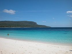
Jaco Island lies just off the eastern end of the island of Timor, part of the Tutuala subdistrict in Lautém District, and is separated from the mainland in front of Valu Beach by a 600 m-wide (660 yd) channel or strait (known as Jaco Strait) navigable by small vessels.

Tourists are ferried to Jaco on fishing boats like these 2017-02-16 Jaco 3.jpg
Tourists are ferried to Jaco on fishing boats like these

Jaco is regarded as sacred by the local population because the beach and the channel are sometimes said to be the points where Timor Sea (Tasi Mane, the men's sea) meets the boundary between the Banda Sea (Tasi Feto, the women's sea) including Wetar Strait to the north and Timor Sea to the south. [3] [4] According to the standard work Limits of Oceans and Seas, 3rd edition (1953), published by the International Hydrographic Organization (IHO), however, the only point where Timor meets those two seas is Tanjong Sewirawa (now known as Cape Cutcha), the eastern extremity of the Timorese mainland. [5] [6] Cape Cutcha is a short distance northwest of the island, and north of the beach. [6] In principle, entering the island, fishing and swimming were therefore forbidden (Tara Bandu). Today, however, fishermen drive tourists from the opposite Valu Beach to the sandy beaches of Jaco for snorkelling and diving. Overnight stays on the island are still not allowed. In February and March, mechi, large feasts of Meci worms (Eunice viridis) are harvested from the sea on the north coast. [7]

At least three places on the island have the remains of ancient fortifications built by the local population to protect settlements: Lai Vai, Pitilete and Honolati. In Portuguese, such fortifications are called tranqueira (English: cover, entrenchment). [8] The only modern structure on the island was a lighthouse from the Indonesian occupation period, a white scaffold tower about 35 m high. It was shut down in 2010 and later dismantled. [9]

The island is low-lying, with an area of 11 km2 (4.2 sq mi) and a maximum elevation of about 100 m (330 ft). It is covered mainly by tropical dry forest, fringed by strand vegetation and white sandy beaches. There are some low cliffs on the southern coast.

The East Timorese warship NRTL Jaco is named after the island.

Climate

The average annual temperature is roughly 27 °C (81 °F). On average the island receives 1,436 mm (56.5 in) of rain and the north and east coast of the small island is somewhat drier.

Wildlife

Jaco is listed by BirdLife International as an Important Bird Area. [10] The island supports populations of bar-necked cuckoo-doves, black cuckoo-doves, pink-headed imperial pigeons, streak-breasted honeyeaters, fawn-breasted whistlers, blue-cheeked flowerpeckers, flame-breasted sunbirds and Timor sparrows. [11] Rare birds such as the great cuckoo dove ( Macropygia magna ) and the orpheus fathead ( Pachycephala orpheus ) live on the island, which is around 8 km² in size and up to 100 meters high. Javan rusa ( Rusa timorensis ) are also found here which have become accustomed to drinking salt water due to the island's lack of fresh water. [11] In 2019, about 80 deer were counted on the island. This year, however, as late rains in December withered the greenery, several deer died. 30 of them swam the 600 metres to the shore of Timor to look for food. [12] The beaches in the southeast are used by sea turtles to lay their eggs. Reptiles living on the island include Smooth night skinks and Forest skinks. [11] In the surrounding waters, you can observe whales and dolphins as well as numerous species of fish. [2] [7]


See also

Related Research Articles

<span class="mw-page-title-main">Bass Strait</span> Sea strait between the Australian mainland and Tasmania

Bass Strait is a strait separating the island state of Tasmania from the Australian mainland. The strait provides the most direct waterway between the Great Australian Bight and the Tasman Sea, and is also the only maritime route into the economically prominent Port Phillip Bay.

<span class="mw-page-title-main">Timor Sea</span> Sea between Malay Archipelago and Australia

The Timor Sea is a relatively shallow sea in the Indian Ocean bounded to the north by the island of Timor with Timor-Leste to the north, Indonesia to the northwest, Arafura Sea to the east, and to the south by Australia. The Sunda Trench marks the deepest point of the Timor Sea with a depth of more than 3300 metres, separating the continents of Oceania in the southeast and Asia to the northwest and north. The Timor sea is prone to earthquakes and tsunamis north of the Sunda Trench, due to its location on the Ring of Fire as well as volcanic activity and can experience major cyclones, due to the proximity from the Equator.

<span class="mw-page-title-main">Savu Sea</span> A small sea within Indonesia

The Savu Sea is a small sea within Indonesia named for the island of Savu (Sawu) on its southern boundary. It is bounded by Savu and Rai Jua to the south, the islands of Rote and Timor to the east, Flores and the Alor archipelago to the north/northwest, and the island of Sumba to the west/northwest. Between these islands, it flows into the Indian Ocean to the south and west, the Flores Sea to the north, and the Banda Sea to the northeast.

<span class="mw-page-title-main">Lautém Municipality</span> Municipality of East Timor

Lautém is one of the municipalities of East Timor, at the eastern end of the country. It has a population of 64,135 and an area of 1,813 km². Its capital is Lospalos, which lies 248 km east of the national capital, Dili.

<span class="mw-page-title-main">Ombai Strait</span> Strait in Southeast Asia

Ombai Strait is an international strait in Southeast Asia. It separates the Alor Archipelago from the islands of Wetar, Atauro, and Timor in the Lesser Sunda Islands. The strait is also the western portion of a pair of international straits, the other one being Wetar Strait; the two straits combine to link the Pacific Ocean with the Indian Ocean.

<span class="mw-page-title-main">Wetar Strait</span> Strait in Southeast Asia

Wetar Strait is an international strait in Southeast Asia. It separates the island of Wetar from the eastern part of the island of Timor. The strait is also the eastern portion of a pair of international straits, the other one being Ombai Strait; the two straits combine to link the Indian Ocean with the Pacific Ocean.

<span class="mw-page-title-main">Nino Konis Santana National Park</span> National park in East Timor

The Nino Konis Santana National Park is East Timor's first national park. The park, established on 15 August 2007, covers 1,236 square kilometres (477 sq mi). It links important bird areas such as Lore, Mount Paitchau, Lake Ira Lalaro, and Jaco Island. The park also includes 556 square kilometres (215 sq mi) of the Coral Triangle, an underwater area which supposedly contains the world's greatest diversity of both coral and coral reef fish. Some of the rare birds protected by this park are the critically endangered yellow-crested cockatoo, the endemic Timor green-pigeon, the endangered Timor imperial-pigeon, and the vulnerable Timor sparrow.

<span class="mw-page-title-main">Timor and Wetar deciduous forests</span> Ecoregion in Indonesia and East Timor

The Timor and Wetar deciduous forests is a tropical dry forest ecoregion in Indonesia and East Timor. The ecoregion includes the islands of Timor, Wetar, Rote, Savu, and adjacent smaller islands.

<span class="mw-page-title-main">Borders of the oceans</span> Limits of Earths oceanic waters

The borders of the oceans are the limits of Earth's oceanic waters. The definition and number of oceans can vary depending on the adopted criteria. The principal divisions of the five oceans are the Pacific Ocean, Atlantic Ocean, Indian Ocean, Southern (Antarctic) Ocean, and Arctic Ocean. Smaller regions of the oceans are called seas, gulfs, bays, straits, and other terms. Geologically, an ocean is an area of oceanic crust covered by water.

<span class="mw-page-title-main">Tutuala</span> Suco and town in Lautém District, East Timor

Tutuala is a village and suco in the subdistrict of Tutuala. It is situated at the extreme eastern end of Timor. Its population at the 2004 census was 3,707. The subdistrict of Tutuala comprises two sucos, including Mehara and Tutuala with the subdistrict administrator residing in Tutuala. The suco of Tutuala comprised four hamlets (aldeia): Ioro, Pitileti, Tchailoro, and Vero. The main Fataluku language areas of the country are in Tutuala, as well as Lautem and Fuiloro.

Nino Konis Santana was an East Timorese freedom fighter who led the Falintil militia between April 1993 and his death in March 1998 during the Indonesian occupation of East Timor, succeeding Ma'huno Bulerek Karathayano after the latter's capture in 1993. Santana died in an accident, after he was shot in the leg during an Indonesian ambush. He was succeeded by Taur Matan Ruak.

<span class="mw-page-title-main">Tasitolu</span> Protected area in East Timor

Tasitolu is a protected area on the coast of East Timor, 8 kilometres (5.0 mi) west of the capital Dili. The Tasitolu wetlands include three saline lakes, an esplanade, and a beach; it has been designated a Wetland of National Significance. Tasitolu Peace Park was designated in 2002 because of its cultural and historical importance. The Tasitolu Important Bird Area accommodates several near-threatened species. A 2004 reforestation project, which included community member participation, was funded by the national government. Subsequent to the 2006 East Timorese crisis, several hundred people sought refuge at Tasitolu's tent camp, established by the United Nations High Commissioner for Refugees. INTERFET, an Australian-led international military Peace Keeping Force governed by the United Nations, has established a base at Tasitolu.

<span class="mw-page-title-main">Ira Lalaro</span> Body of water

Lake Ira Lalaro is a freshwater lake in Mehara, Subdistrict Tutuala, Lautém District, East Timor. It is the largest of the island of Timor, and thus too of the country. The lake is part of the Mount Paitchau Important Bird Area. The lake waters and that of Irasiquero River are a closed aquatic system; they lie within a huge polje. It covers between 10–55 square kilometres (3.9–21.2 sq mi) while the authigenic catchment basin covers 406 square kilometres (157 sq mi).

<span class="mw-page-title-main">Paitchau</span> Mountain in East Timor

Paitchau is a mountain in the Tutuala subdistrict, Lautém District of East Timor. Situated within Nino Konis Santana National Park, it is south of Lake Ira Lalaro. Though part of a mountain chain, Paitchau is an isolated mountain in the southern Sucos Mehara. It ranges in altitude from 0–960 metres (0–3,150 ft). BirdLife International has classified the mountain and its surrounding region of 55,797 hectares as an Important Bird Area of East Timor. The area contained within the Paitchau Range and Ira Lalaro is sparsely populated and contains several unique faunal and floral species.

<span class="mw-page-title-main">Loré Important Bird Area</span>

The Loré Important Bird Area is a 10,906 ha tract of land in East Timor, a country occupying the eastern end of the island of Timor in the Lesser Sunda Islands of Wallacea. It forms the south-westernmost part of the Nino Konis Santana National Park.

<span class="mw-page-title-main">Cape Fugui</span>

Cape Fugui, Cape Fukwei, Fukwei Chiao, Fuguei Cape, or Fugui Cape is a cape located at the northernmost point of the island of Taiwan. It is located in Cape Fugui Park within the Shimen District in New Taipei City.

<span class="mw-page-title-main">One Dollar Beach</span> Beach near Dili, East Timor

One Dollar Beach or Dollar Beach is a public beach on the north coast of East Timor, east north east of Dili, the capital city. It is long, white, sandy and clean, and also frequently deserted, yet popular with beach users at other times.

<span class="mw-page-title-main">Valu Beach</span> Beach in East Timor

Valu Beach is a public beach at the easternmost tip of mainland East Timor, and the gateway to Jaco Island to its east.

<i>Cyrtodactylus santana</i> Species of gecko from East Timor

Cyrtodactylus santana is a species of gecko found in the Nino Konis Santana National Park, which is located at the eastern end of East Timor. It is thought to be nocturnal, and to inhabit limestone caves. Described in January 2023, it is the first Cyrtodactylus species described from East Timor, and remains understudied.

References

  1. Trainor, Colin R. (2007). As aves de Timor-Leste = Burung-burung di Timor-Leste = The birds of Timor-Leste. Brian J. Coates, K. David Bishop, Brian J. Coates, BirdLife International. [Cambridge]: BirdLife International. ISBN   0-946888-58-2. OCLC   317403946.
  2. 1 2 "Brochure of the Nino Konis Santana National Park" (PDF). UK Government Web Archive. Retrieved 2023-04-06.
  3. "East Timor Travel: Why Go to a Country So Few People Ever Visit?". Women on the Road. 19 March 2019. Retrieved 9 July 2022.
  4. Sailing Directions for Java: Lesser Sundas; South, Southeast, and East Coasts of Borneo; and Celebes. Publication - Defense Mapping Agency, Hydrographic Center, no. 72 (revised 5th (1962) ed.). Washington, DC: U.S. Dept. of Defense, Defense Mapping Agency, Hydrographic Center. 1976. p. 272. ISBN   1038099951.
  5. Limits of Oceans and Seas (PDF). Special Publication No 28 (3rd ed.). Monte-Carlo: International Hydrographic Organization (IHO). 1953. Archived from the original (PDF) on 8 October 2011. Retrieved 28 December 2020.
  6. 1 2 Timor-Leste (PDF) (Map). Cartography by Department of Peacekeeping Operations, Cartographic Section. United Nations (UN). January 2004. Map No. 4111 Rev. 8. Retrieved 16 July 2022.
  7. 1 2 "The Timor-Leste Coastal/Marine Habitat Mapping for Tourism and Fisheries Development Project, Project No 4, Conservation Values, Issues and Planning in the Nino Konis Santana Marine Park, Timor Leste - Final Report" (PDF). cdu.edu (4th no. ed.). October 2009. Archived from the original on 2013-03-29. Retrieved 2023-04-06 via Archive.org.{{cite web}}: CS1 maint: unfit URL (link)
  8. Sue O'Connor; McWilliam, Andrew; Brockwell, Sally (2020). Forts and Fortification in Wallacea: Archaeological and Ethnohistoric Investigations (PDF). ANU Press 2020. pp. 257–262.
  9. Rowlet, Russ (2018-03-15). "The Lighthouse Directory: Lighthouses of Timor-Leste (East Timor)". University of North Carolina. Archived from the original on 2018-03-15. Retrieved 2023-04-06 via Archive.org.
  10. BirdLife International. "BirdLife Data Zone: Jaco Island" . Retrieved May 5, 2020.
  11. 1 2 3 "Herpetological Diversity of Timor-Leste: Updates and a Review of Species Distributions - CNKI". www.cnki.net. doi:10.16373/j.cnki.ahr.140066 . Retrieved 2023-04-06.
  12. Baird, Robert; Miranda Ximenes, Florencio (16 December 2019). "Timor's Native Deer in Desperate Bid for Survival |". TATOLI Agência Noticiosa de Timor-Leste. Archived from the original on 2019-12-18. Retrieved 2023-04-06 via Archive.org.

Commons-logo.svg Media related to Jaco Island at Wikimedia Commons