List of Mountain Bothies Association bothies

Last updated

Corrour bothy in the Scottish Highlands Corrour Bothy - geograph.org.uk - 1546559.jpg
Corrour bothy in the Scottish Highlands

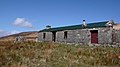
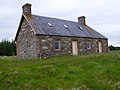
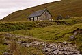
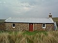
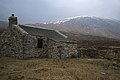
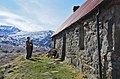
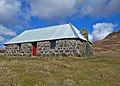
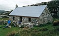
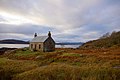
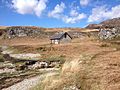
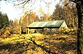
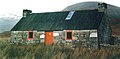
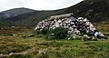
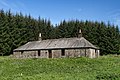
Bothies are remote, rural cottages that have outlived their original purposes but now are kept unlocked for people to take shelter or stay overnight without charge. They are located mostly in Scotland, with a small number in England and Wales, and have extremely basic facilities - with no electricity, gas, or piped water. The Mountain Bothies Association, established in 1965, is a charity that maintains bothies.

Contents

Background

Bothies

Lonbain deserted village, Applecross Lonbain Ruined Village - geograph.org.uk - 182287.jpg
Lonbain deserted village, Applecross

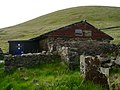
Bothies are primitive shelters found primarily in Scotland (particularly in the Highlands) but also in remote parts of Wales and northern England. Highland Scotland has a low density of population by European standards, and in many remote areas the population has declined over the last 200 years due to emigration following the Highland Clearances and the Highland Potato Famine, together with migration to the cities because of industrialisation. [1] [2] In consequence, ruined but and ben cottages are often found abandoned in remote areas. Bothies were built for deer stalking (deer shooting), quarrying, cattle droving and shepherding but these have also fallen out of use. [3]

The owners of these abandoned properties sometimes allow them be used freely by backpackers, climbers and the like – they are simply kept unlocked. There is no charge for use but neither are there any facilities – they have no electricity or piped water supply. [4]

Mountain Bothies Association

Notice on the door of Greg's Hut, Cross Fell Gregs Hut on Cross Fell (geograph 4693330).jpg
Notice on the door of Greg's Hut, Cross Fell

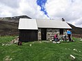
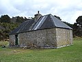
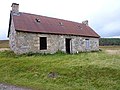
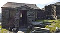
The Mountain Bothies Association was established in 1965, becoming a Scottish charity in 1975, to take on the basic care and maintenance of some of these shelters, with the cooperation of the owners who sometimes help financially. [5] The first bothy to be restored was Tunskeen. [6] The organisation has over ninety bothies, mostly in Scotland but with a few in England and Wales all of which may be stayed in without any charges at all. [7] [5] Very rarely is there vehicular access and in some cases, even those located on the mainland are more directly accessible by boat.

"Bothy TV" Fuego1.JPG
"Bothy TV"

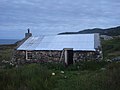
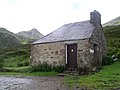
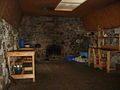
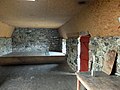
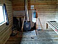
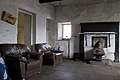
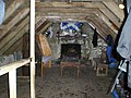
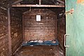
The MBA aims to keep its properties windproof and waterproof so someone checks them a few times a year. [8] At minimum there will be a table and a few chairs, and many bothies have a fireplace or stove although plenty do not. [9] [10] [11] Fuel needs to be carried in (coal is best) – a blazing fire is known as "bothy TV". [12] MBA bothies sometimes have an outside toilet but when this is not the case a toilet spade is provided. Raised platforms or bunks have been installed for sleeping – sometimes the floor, particularly an attic floor, is also suitable. [9]

Bothy book at Greg's Hut (2015) Signing the visitors book at Gregs Hut, Cross Fell (geograph 4693333).jpg
Bothy book at Greg's Hut (2015)

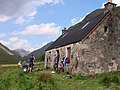
Visitors are expected to bring food and bedding with them. Sometimes there are books, cooking equipment and so forth left by previous visitors. A bothy book (visitors' book) is an important aspect of bothying culture. [13] [14] There is no system for reserving places or checking availability so, if the need arises, more people may squeeze in even if it means that some other people may decide to sleep outside in their tents. [15] [16] [17] Visitors are only expected to stay for a short period – for a night or two – before moving on. [18] Large groups – six or more – and commercial groups are not allowed. [19]

Deer stalking in Scotland

The Deer Drive, Landseer, 1847 The Deer Drive, Landseer, 1847.jpg
The Deer Drive, Landseer, 1847

In the Scottish Highlands many bothies are situated on deer stalking estates and so in the stalking season the land owner may restrict access or the bothy may be closed completely. Red deer stag hunting is from 1 July to 20 October (often starting 15 September) and this is the time of the greatest likelihood of restrictions. However, hind culling starts 21 October and can extend into February. Elsewhere, in sheep country, the shepherds themselves may need to use a bothy at lambing time and they take priority over visitors. Estates often ask visitors to telephone in advance to enquire about restrictions. Warning notices will be displayed and a website maintains up-to-date access arrangements throughout Scotland. [20] [21] [19] [22]

List of MBA bothies

This sortable list includes all the Mountain Bothies Association bothies as of June 2024 as listed on their website. [23] Traditionally these locations were not published but a change of policy in 2009 led to the locations being made openly available. [24] [25] In 2017 Geoff Allan published The Scottish Bothy Bible (referred to in the table as SBB), detailing all MBA bothies in Scotland as well as many other non-MBA bothies. [26] [27] Publication of this and other guides in recent years has led to controversy over the publicity of bothies and the 'bothy experience'. Some believe increased publicity in respect of bothies (as opposed to publicity of the maintenance work of the MBA) is detrimental to their long term sustainability. [28] It has also been suggested that there should be a subcategory of bothies that are not publicised and are known only to MBA members, or alternatively, for no new bothies to be published beyond the MBA membership. [29]

List of MBA bothies
MBA region [23]
[note 1]
Name [23] District [23] Grid ref [23]
Lat/long [26]
[note 2]
Sleeps [26]
  [note 3]
Elevation [26]
[note 4]
Estate [23] PhotoNotes
Northern HighlandsAchnanclach Sutherland NC630511
58°25′37″N4°20′46″W / 58.427°N 4.346°W / 58.427; -4.346 (Achnanclach)
many148 m (486 ft)Syre Achnanclach cottage - geograph.org.uk - 1206385.jpg MBA [30] SBB, 43. [31]
Northern HighlandsCoiremor, Magoo's Bothy Ross-shire NH305888
57°51′25″N4°51′29″W / 57.857°N 4.858°W / 57.857; -4.858 (Coiremor, Magoo's Bothy)
many318 m (1,043 ft)Corriemulzie Building, Loch a' Choire Mhoir - geograph.org.uk - 782636.jpg MBA [32] SBB, 45. [33]
Northern HighlandsCroft House, Lochstrathy Sutherland NC793490
58°24′43″N4°04′01″W / 58.412°N 4.067°W / 58.412; -4.067 (Croft House, Lochstrathy)
many160 m (525 ft)Strathy South Loch Strathy house - geograph.org.uk - 1170994.jpg MBA [34] SBB, 61. [35]
Northern HighlandsGlencoul Sutherland NC270303
58°13′41″N4°56′49″W / 58.228°N 4.947°W / 58.228; -4.947 (Glencoul)
411 m (36 ft)Reay Forest House and bothy, Glencoul (geograph 4010388).jpg Best approached by water.
MBA [36] SBB, 49; [37] also. [38]
Northern HighlandsGlendhu Sutherland NC283337
58°15′32″N4°55′41″W / 58.259°N 4.928°W / 58.259; -4.928 (Glendhu)
0+ upstairs25 m (82 ft)Reay Forest Glendhu bothy (geograph 2228354).jpg MBA [39] SBB, 53. [40]
Northern HighlandsKearvaig Sutherland NC292727
58°36′32″N4°56′28″W / 58.609°N 4.941°W / 58.609; -4.941 (Kearvaig)
2+ attic9 m (30 ft)Cape Wrath (MoD) Kearvaig Bothy - geograph.org.uk - 1014991.jpg MBA [41] SBB, 55. [42]
Northern HighlandsKnockdamph Sutherland NH285953
57°54′54″N4°53′42″W / 57.915°N 4.895°W / 57.915; -4.895 (Knockdamph)
many233 m (764 ft)East Rhidorroch Knockdamph bothy - geograph.org.uk - 586929.jpg MBA [43] SBB, 59. [44]
Northern HighlandsSchoolhouse, Duag Bridge Sutherland NH340975
57°56′06″N4°48′18″W / 57.935°N 4.805°W / 57.935; -4.805 (Schoolhouse, Duag Bridge)
599 m (325 ft)Corriemulzie Estate building at Duag Bridge (geograph 2023141).jpg MBA [45] SBB, 77;. [46] also. [47]
Northern HighlandsShenavall Wester Ross NH066810
57°46′37″N5°15′14″W / 57.777°N 5.254°W / 57.777; -5.254 (Shenavall)
many128 m (420 ft)Gruinard Shenavall Bothy - geograph.org.uk - 1309943.jpg Busy.
MBA [48] SBB, 63; [49] also. [50]
Northern HighlandsStrabeg Sutherland NC391518
58°25′30″N4°45′22″W / 58.425°N 4.756°W / 58.425; -4.756 (Strabeg)
many35 m (115 ft)Eriboll Welcome sight at Strabeg (geograph 1807290).jpg Easy access.
MBA [51] SBB, 67. [52]
Northern HighlandsStrathan Sutherland NC247612
58°30′11″N5°00′36″W / 58.503°N 5.010°W / 58.503; -5.010 (Strathan)
2+62 m (203 ft)Keoldale Strathan Bothy - geograph.org.uk - 1252730.jpg Near Sandwood Bay.
MBA 15; [53] SBB, 69. [54]
Northern HighlandsStrathchailleach Sutherland NC249658
58°32′42″N5°00′36″W / 58.545°N 5.010°W / 58.545; -5.010 (Strathchailleach)
295 m (312 ft)Keoldale Strathchailleach Bothy - geograph.org.uk - 571708.jpg Near Sandwood Bay.
MBA [55] SBB, 71; [56] also. [57]
Northern HighlandsSuileag Sutherland NC149212
58°08′24″N5°08′42″W / 58.140°N 5.145°W / 58.140; -5.145 (Suileag)
8137 m (449 ft)Glencanisp Suileag Bothy (geograph 3398712).jpg MBA [58] SBB, 75. [59]
North West Highlands and IslandsBearnais Wester Ross NH021431
57°26′02″N5°17′53″W / 57.434°N 5.298°W / 57.434; -5.298 (Bearnais)
2279 m (915 ft) Attadale Bearnais Bothy in 1978 - geograph.org.uk - 1766831.jpg MBA [60] SBB, 85. [61]
North West Highlands and IslandsCamasunary (new) Skye NG517183
57°11′24″N6°06′43″W / 57.190°N 6.112°W / 57.190; -6.112 (Camasunary)
165 m (16 ft) Camasunary Camasunary bothy (geograph 5300100).jpg New bothy. [note 5]
MBA [62] SBB, 285. [63]
North West Highlands and IslandsCamban Kintail NH053184
57°12′50″N5°13′30″W / 57.214°N 5.225°W / 57.214; -5.225 (Camban)
many279 m (915 ft)West Affric (NTS) Camban bothy from the east (geograph 5333836).jpg MBA [64] SBB, 89. [65]
North West Highlands and IslandsCoire Fionnaraich Wester Ross NG950480
57°28′34″N5°25′16″W / 57.476°N 5.421°W / 57.476; -5.421 (Coire Fionnaraich)
many180 m (591 ft)Fionnaraich Coire Fionnaraich Bothy (geograph 3142443).jpg MBA [66] SBB, 93. [67]
North West Highlands and IslandsCraig Wester Ross NG774639
57°36′36″N5°43′37″W / 57.610°N 5.727°W / 57.610; -5.727 (Craig)
many83 m (272 ft) SYHA Craig - geograph.org.uk - 1175411.jpg MBA [68] SBB, 95; [69] also. [70]
North West Highlands and IslandsEasan Dorcha (The Teahouse) Wester Ross NH012526
57°31′08″N5°19′23″W / 57.519°N 5.323°W / 57.519; -5.323 (Easan Dorcha (Teahouse))
0 [note 6] 215 m (705 ft)Coulin Easan Dorcha Bothy (geograph 4424616).jpg MBA [71] SBB, 103; [72] also. [73]
North West Highlands and IslandsLookout (Rubha Hunish) Skye NG412763
57°42′04″N6°20′38″W / 57.701°N 6.344°W / 57.701; -6.344 (Lookout)
3+ 4 floor82 m (269 ft)MBA The Lookout - geograph.org.uk - 560832.jpg Ex-coastguard station, hence excellent views.
MBA [74] SBB, 293; [75] also. [76]
North West Highlands and IslandsMaol Bhuidhe Wester Ross NH053360
57°22′19″N5°14′28″W / 57.372°N 5.241°W / 57.372; -5.241 (Maol Bhuidhe)
many in attic261 m (856 ft)Killilan Maol Bhuidhe Bothy - geograph.org.uk - 105129.jpg MBA [77] SBB, 97. [78]
North West Highlands and IslandsOllisdal Skye NG213394
57°21′36″N6°38′10″W / 57.360°N 6.636°W / 57.360; -6.636 (Ollisdal)
small89 m (292 ft) Glendale Ollisdal Bothy (geograph 3399958).jpg Interior photo.
MBA [79] SBB, 287. [80]
North West Highlands and IslandsTaigh Thormoid Dhuibh (Raasay) Skye NG612524
57°29′56″N5°59′17″W / 57.499°N 5.988°W / 57.499; -5.988 (Taigh Thormoid Dhuibh)
615 m (49 ft) Raasay Tigh Thormoid Dhuibh - geograph.org.uk - 1210951.jpg Island of Raasay, interior photos.
MBA [81] SBB, 291. [82]
North West Highlands and IslandsUags Applecross NG723351
57°20′56″N5°47′13″W / 57.349°N 5.787°W / 57.349; -5.787 (Uags)
1+ attic23 m (75 ft) Applecross The bothy at Uags - geograph.org.uk - 228364.jpg MBA [83] SBB, 105. [84]
North West Highlands and IslandsUisinis Outer Hebrides NF849332
57°16′48″N7°13′52″W / 57.280°N 7.231°W / 57.280; -7.231 (Uisinis)
424 m (79 ft) South Uist Uisinis Bothy (geograph 1649242).jpg Island of South Uist.
MBA [85] SBB, 297. [86]
Western HighlandsA' Chuil Lochaber NM944924
56°58′37″N5°23′02″W / 56.977°N 5.384°W / 56.977; -5.384 (A' Chuil)
7 [note 7] 137 m (449 ft)Glendessary A' Chuil Bothy - geograph.org.uk - 1418039.jpg Busy but rarely full.
MBA [88] SBB, 111. [89]
Western HighlandsDibidil Rùm NM393928
56°57′07″N6°17′20″W / 56.952°N 6.289°W / 56.952; -6.289 (Dibidil)
629 m (95 ft) Scottish Natural Heritage Dibidil - geograph.org.uk - 904388.jpg Island of Rùm.
MBA [90] SBB, 275. [91]
Western Highlands Gleann Dubh-lighe Lochaber NM945820
56°53′02″N5°22′30″W / 56.884°N 5.375°W / 56.884; -5.375 (Gleann Dubh-lighe)
2+128 m (420 ft)Fassfern Gleann Dubh-lighe (Bothy) (geograph 2540980).jpg MBA [92] SBB, 117. [93]
Western HighlandsGlenpean Lochaber NM936904
56°57′29″N5°23′46″W / 56.958°N 5.396°W / 56.958; -5.396 (Glenpean)
2+ large attic106 m (348 ft)Glendessary Glenpean Bothy (geograph 2266304).jpg MBA [94] SBB, 119. [95]
Western HighlandsGuirdil Rùm NG320014
57°01′30″N6°25′05″W / 57.025°N 6.418°W / 57.025; -6.418 (Guirdil)
4+21 m (69 ft) Scottish Natural Heritage Guirdil Bothy - geograph.org.uk - 643000.jpg Island of Rùm.
MBA [96] SBB, 281. [97]
Western HighlandsInvermallie Lochaber NN136888
56°57′11″N5°04′01″W / 56.953°N 5.067°W / 56.953; -5.067 (Invermallie)
4+ large attic45 m (148 ft)Locheil Invermallie Bothy (geograph 4068690).jpg Busy.
MBA [98] SBB, 123. [99]
Western HighlandsKinbreack Lochaber NN002961
57°00′47″N5°17′31″W / 57.013°N 5.292°W / 57.013; -5.292 (Kinbreack)
0+ small attic182 m (597 ft) [note 8] Locheil Ceannbreac (geograph 2358274).jpg Interior photo.
MBA [100] SBB, 125. [101]
Western HighlandsOban Lochaber NM863901
56°57′07″N5°30′54″W / 56.952°N 5.515°W / 56.952; -5.515 (Oban)
many11 m (36 ft)Meoble Oban bothy and Sron a Choin (geograph 2400420).jpg MBA [102] SBB, 129. [103]
Western HighlandsSourlies Lochaber NM868951
56°59′49″N5°30′47″W / 56.997°N 5.513°W / 56.997; -5.513 (Sourlies)
824 m (79 ft)Camusrory "Sourlies" MBA (geograph 2412000).jpg Busy in summer.
MBA [104] SBB, 135. [105]
Western HighlandsSuardalan Lochaber NG883173
57°11′49″N5°30′22″W / 57.197°N 5.506°W / 57.197; -5.506 (Suardalan)
9113 m (371 ft)Glenelg Grazing Suardalan - geograph.org.uk - 1191329.jpg MBA [106] SBB, 101. [107]
Southwest Highlands and IslandsAbyssinia Loch Lomond NN256117
56°15′58″N4°49′05″W / 56.266°N 4.818°W / 56.266; -4.818 (Abyssinia)
8250 m (820 ft) [note 9] Strone [108] Abyssinia (geograph 5143677).jpg MBA [109] also. [110]
Southwest Highlands and IslandsCadderlie North Argyll NN047370
56°29′10″N5°10′30″W / 56.486°N 5.175°W / 56.486; -5.175 (Cadderlie)
414 m (46 ft)Loch Etive Cadderlie (geograph 2606192).jpg MBA [111] SBB, 207. [112]
Southwest Highlands and IslandsCarron Knapdale NR944996
56°08′42″N5°18′40″W / 56.145°N 5.311°W / 56.145; -5.311 (Carron)
2+ floor188 m (617 ft)Ederline Carron Bothy - geograph.org.uk - 1195180.jpg MBA [113] SBB, 211. [114]
Southwest Highlands and IslandsCruib Jura NR567829
55°58′37″N5°54′07″W / 55.977°N 5.902°W / 55.977; -5.902 (Cruib)
52 m (7 ft)Ruantallaine Cruib Bothy (geograph 3967431).jpg Island of Jura.
MBA [115] SBB, 273. [116]
Southwest Highlands and IslandsDoune Byre Loch Lomond NN332144
56°17′35″N4°41′46″W / 56.293°N 4.696°W / 56.293; -4.696 (Doune Byre)
471 m (233 ft)Glenfalloch Doune Byre (Bothy) (geograph 5107475).jpg West Highland Way.
MBA [117] SBB, 215p. [118]
Southwest Highlands and IslandsDruimnashallog Lorne NM898164
56°17′38″N5°23′46″W / 56.294°N 5.396°W / 56.294; -5.396 (Druimnashallog)
0 [note 10] 160 m (525 ft) [note 9] Forestry and Land Scotland Druimnashallach - geograph.org.uk - 1047315.jpg MBA [119]
Southwest Highlands and IslandsEssan Wester Ross NM817817
56°52′30″N5°35′02″W / 56.875°N 5.584°W / 56.875; -5.584 (Essan)
1234 m (112 ft)Inverailort Essan (geograph 3652997).jpg MBA [120] SBB, 115. [121]
Southwest Highlands and IslandsGlengarrisdale Jura NR644970
56°06′25″N5°47′24″W / 56.107°N 5.790°W / 56.107; -5.790 (Glengarrisdale)
47 m (23 ft)Ardlussa Glen Garrisdale bothy - geograph.org.uk - 1206442.jpg Island of Jura.
MBA [122] SBB, 279. [123]
Southwest Highlands and IslandsLeacraithnaich Ardgour NM742472
56°33′43″N5°40′34″W / 56.562°N 5.676°W / 56.562; -5.676 (Leacraithnaich)
4148 m (486 ft) Ardtornish Cottage overlooking Loch Tearnait (geograph 2228725).jpg MBA [124] SBB, 221. [125]
Southwest Highlands and IslandsMark Cottage Loch Lomond NS229952
56°06′58″N4°50′56″W / 56.116°N 4.849°W / 56.116; -4.849 (Mark Cottage)
69 m (30 ft) Forestry Commission Mark Cottage(Bothy) (geograph 2523666).jpg MBA [126] SBB, 223. [127]
Southwest Highlands and IslandsResourie Ardgour NM861710
56°46′52″N5°30′07″W / 56.781°N 5.502°W / 56.781; -5.502 (Resourie)
10139 m (456 ft)Glenhurich Forest Resourie bothy - geograph.org.uk - 345759.jpg MBA [128] SBB, 225. [129]
Southwest Highlands and IslandsRowchoish Loch Lomond NN336043
56°12′07″N4°41′02″W / 56.202°N 4.684°W / 56.202; -4.684 (Rowchoish)
1241 m (135 ft)East Lomond Forest Rowchoish Bothy - geograph.org.uk - 1040554.jpg West Highland Way.
MBA [130] SBB, 227. [131]
Southwest Highlands and IslandsTaigh Seumas a' Ghlinne, Glen Duror Lochaber NN022539
56°38′06″N5°13′37″W / 56.635°N 5.227°W / 56.635; -5.227 (Taigh Seumas a' Ghlinne)
4203 m (666 ft)Lorne Forest The bothy in Duror Forext (geograph 3152858).jpg MBA [132] SBB, 217; [133] also. [134]
Southwest Highlands and IslandsTomsleibhe Mull NM617372
56°27′58″N5°52′08″W / 56.466°N 5.869°W / 56.466; -5.869 (Tomsleibhe)
1094 m (308 ft) [note 11] Glen Forsa Tomsleibhe - geograph.org.uk - 1362444.jpg Isle of Mull.
MBA [135] SBB, 295. [136]
Central HighlandsBen Alder Cottage Rannoch NN499680
56°46′44″N4°27′32″W / 56.779°N 4.459°W / 56.779; -4.459 (Ben Alder Cottage)
4373 m (1,224 ft)Ben Alder Benalder Cottage (geograph 4612876).jpg MBA [137] SBB, 143. [138]
Central HighlandsBlackburn of Corrieyairack Monadhliath NH382029
57°05′17″N4°40′19″W / 57.088°N 4.672°W / 57.088; -4.672 (Blackburn of Corrieyairack)
0+ 8 floor344 m (1,129 ft)Culachy Blackburn of Corrieyairack bothy (geograph 4607489).jpg MBA [139] SBB, 147; [140] also. [141]
Central HighlandsCulra-NN523762
56°51′14″N4°25′26″W / 56.854°N 4.424°W / 56.854; -4.424 (Culra)
0 [note 12] 457 m (1,499 ft)Ben Alder Culra Bothy - geograph.org.uk - 198199.jpg Permanently closed. [note 12]
MBA [142] SBB, 144. [143]
Central HighlandsGlenbuck Monadhliath NN336996
57°03′25″N4°44′46″W / 57.057°N 4.746°W / 57.057; -4.746 (Glenbuck)
many283 m (928 ft)Aberchalder Estate building at Glenbuck (geograph 2228350).jpg MBA [144] SBB, 149; [145] also. [146]
Central HighlandsGorton Rannoch NN375481
56°35′49″N4°38′56″W / 56.597°N 4.649°W / 56.597; -4.649 (Gorton)
0+ floor299 m (981 ft)Blackmount Gorton, Sunny Sunday (geograph 2692871).jpg MBA [147] SBB, 219. [148]
Central HighlandsLairig Leacach Lochaber NN282738
56°49′23″N4°48′58″W / 56.823°N 4.816°W / 56.823; -4.816 (Lairig Leacach)
8467 m (1,532 ft)Killiechonate and Mamores Lairig Leacach Bothy.jpg Busy.
MBA [149] SBB, 151; [150] also. [151]
Central HighlandsLoch Chiarain Lochaber NN289634
56°43′52″N4°47′53″W / 56.731°N 4.798°W / 56.731; -4.798 (Loch Chiarain)
1+ large attic370 m (1,214 ft)Killiechonate and Mamores Loch Chiarain bothy - geograph.org.uk - 306962.jpg MBA [152] SBB, 153. [153]
Central HighlandsLuib Chonnal Monadhliath NN394936
57°00′22″N4°38′46″W / 57.006°N 4.646°W / 57.006; -4.646 (Luib Chonnal)
0+ attic331 m (1,086 ft)Braeroy Luib Chonnal bothy - geograph.org.uk - 440052.jpg MBA [154] SBB, 155. [155]
Central HighlandsMeanach Lochaber NN266685
56°46′30″N4°50′20″W / 56.775°N 4.839°W / 56.775; -4.839 (Meanach)
3345 m (1,132 ft)Killiechonate and Mamores Estate building at Meannanach (geograph 2228759).jpg MBA [156] SBB, 157. [157]
Central HighlandsStaoineag Lochaber NN296678
56°46′16″N4°47′28″W / 56.771°N 4.791°W / 56.771; -4.791 (Staoineag)
many293 m (961 ft)Killiechonate and Mamores Staoineag bothy (geograph 1951891).jpg MBA [158] SBB, 161. [159]
Eastern HighlandsAllt Scheicheachan Badenoch NN835737
56°50′24″N3°54′43″W / 56.840°N 3.912°W / 56.840; -3.912 (Allt Scheicheachan)
2+ attic487 m (1,598 ft)Atholl Allt Sheicheachan Bothy Glen Bruar, Perthshire - geograph.org.uk - 11195.jpg Interior photo. Not at all busy.
MBA [160] SBB, 167. [161]
Eastern HighlandsCallater Stable Mounth NO178845
56°56′38″N3°21′11″W / 56.944°N 3.353°W / 56.944; -3.353 (Callater Stable)
8514 m (1,686 ft) Invercauld Glen Callater Bothy - geograph.org.uk - 14306.jpg MBA [162] SBB, 171. [163]
Eastern HighlandsCharr Mounth NO616831
56°56′17″N2°37′59″W / 56.938°N 2.633°W / 56.938; -2.633 (Charr)
3264 m (866 ft)Glendye Charr Bothy - geograph.org.uk - 1457073.jpg MBA [164] SBB, 185. [165]
Eastern Highlands Corrour Cairngorms NN981958
57°02′31″N3°40′52″W / 57.042°N 3.681°W / 57.042; -3.681 (Corrour)
4564 m (1,850 ft) Mar Lodge (NTS) Two walkers outside Corrour Bothy, Cairngorms (geograph 3748679).jpg Lairig Ghru. Often crowded.
MBA [166] SBB, 175. [167]
Eastern HighlandsFaindouran Cairngorms NJ082062
57°08′13″N3°31′08″W / 57.137°N 3.519°W / 57.137; -3.519 (Faindouran)
2+ attic603 m (1,978 ft)Inchrory Faindouran Lodge bothy (geograph 4373887).jpg MBA [168] SBB, 179. [169]
Eastern HighlandsFords of Avon Refuge Hut [note 13] Cairngorms NJ042032
57°06′36″N3°35′02″W / 57.110°N 3.584°W / 57.110; -3.584 (Fords of Avon Refuge Hut)
0689 m (2,260 ft) Abernethy (RSPB) Fords of Avon Refuge (geograph 2031763).jpg Interior photo.
MBA [170] SBB, 201. [171]
Eastern HighlandsGarbh Choire Refuge [note 13] Cairngorms NN959986
57°04′01″N3°43′05″W / 57.067°N 3.718°W / 57.067; -3.718 (Garbh Choire Refuge)
0710 m (2,329 ft) [note 9] Mar Lodge (NTS) Garbh Choire Bothy - geograph.org.uk - 1397156.jpg MBA [172] also. [173]
Eastern HighlandsGelder Shiel Stable Mounth NO258900
56°59′42″N3°13′26″W / 56.995°N 3.224°W / 56.995; -3.224 (Gelder Shiel Stable)
6444 m (1,457 ft) Balmoral Gelder Shiel (geograph 3971777).jpg MBA [174] SBB, 181; [175] also. [176]
Eastern Highlands Glas Allt Shiel Bothy Loch Muick NO276824
56°55′37″N3°11′28″W / 56.927°N 3.191°W / 56.927; -3.191 (Glas Allt Shiel)
6 in attic400 m (1,312 ft) Balmoral Estate The Royal Bothy - geograph.org.uk - 916439.jpg MBA [177] SBB, 183.
Eastern HighlandsHutchison Memorial Hut Cairngorms NO023998
57°04′41″N3°36′47″W / 57.078°N 3.613°W / 57.078; -3.613 (Hutchison Memorial Hut)
2+ 4 floor747 m (2,451 ft)Mar Lodge (NTS) Hutchison Memorial Hut (geograph 2160303).jpg Interior photo.
MBA [178] SBB, 187; [179] also. [180]
Eastern HighlandsRuigh Aiteachain Cairngorms NN847928
57°00′43″N3°54′00″W / 57.012°N 3.900°W / 57.012; -3.900 (Ruigh Aiteachain)
10+ attic389 m (1,276 ft) Glenfeshie Ruigh-aiteachain Bothy Glen Feshie - geograph.org.uk - 121665.jpg MBA [181] SBB, 189; [182] also. [183]
Eastern Highlands Ruighe Ealasaid (Red House) Cairngorms NO003869
56°57′43″N3°38′35″W / 56.962°N 3.643°W / 56.962; -3.643 (Ruighe Ealasaid)
439 m (1,440 ft) Mar Lodge The Geldie Bothy (geograph 3668507).jpg MBA [note 14] [184] also. [185]
Eastern HighlandsRyvoan Cairngorms NJ006115
57°11′02″N3°38′46″W / 57.184°N 3.646°W / 57.184; -3.646 (Ryvoan)
4394 m (1,293 ft) Abernethy (RSPB) Ryvoan Bothy - geograph.org.uk - 16002.jpg RSPB nature reserve.
MBA [186] SBB, 193; [187] also. [188]
Eastern HighlandsShielin of Mark Mounth NO337827
56°55′48″N3°05′31″W / 56.930°N 3.092°W / 56.930; -3.092 (Shielin of Mark)
2644 m (2,113 ft)Dalhousie Shielin of Mark (geograph 3626194).jpg MBA [189] SBB, 195. [190]
Eastern HighlandsTarf Hotel (Feith Uaine) Badenoch NN927789
56°53′20″N3°45′47″W / 56.889°N 3.763°W / 56.889; -3.763 (Tarf Hotel (Feith Uaine))
7566 m (1,857 ft)Atholl The Tarf Hotel - geograph.org.uk - 426879.jpg Remote.
MBA [191] SBB, 197. [192]
Southern ScotlandBrattleburn Lowther Hills NT016069
55°20′46″N3°33′14″W / 55.346°N 3.554°W / 55.346; -3.554 (Brattleburn)
2+ attic275 m (902 ft)- Brattleburn Bothy (geograph 5262103).jpg MBA [193] SBB, 239. [194]
Southern ScotlandBurlywhag Lowther Hills NS971001
55°17′02″N3°37′19″W / 55.284°N 3.622°W / 55.284; -3.622 (Burlywhag)
2360 m (1,181 ft)Queensberry Burleywhag (MBA bothy) (geograph 4057702).jpg MBA [195] SBB, 241. [196]
Southern ScotlandClennoch Galloway NS603002
55°16′34″N4°12′04″W / 55.276°N 4.201°W / 55.276; -4.201 (Clennoch)
6416 m (1,365 ft)Moorbrock Clennoch bothy (geograph 2454307).jpg MBA [197] SBB, 243. [198]
Southern ScotlandDryfehead Dumfriesshire NY170999
55°17′10″N3°18′29″W / 55.286°N 3.308°W / 55.286; -3.308 (Dryfehead)
6310 m (1,017 ft)Tanlawhill Farm, Tilhill Forestry Dryfehead - geograph.org.uk - 1320932.jpg Bothy restored since photo taken.
MBA [199] SBB, 247. [200]
Southern ScotlandGameshope Dumfriesshire NT135185
55°27′11″N3°22′16″W / 55.453°N 3.371°W / 55.453; -3.371 (Gameshope)
8419 m (1,375 ft)Borders Forest Gameshope (Bothy) (geograph 2542439).jpg MBA [201] SBB, 249. [202]
Southern ScotlandGreensykes Dumfriesshire NT312000
55°17′24″N3°05′02″W / 55.290°N 3.084°W / 55.290; -3.084 (Greensykes)
8268 m (879 ft)Greensykes Greensykes (geograph 5283012).jpg MBA [203] SBB, 251. [204]
Southern ScotlandKettleton Byre Lowther Hills NS912021
55°18′04″N3°42′58″W / 55.301°N 3.716°W / 55.301; -3.716 (Kettleton Byre)
4356 m (1,168 ft)Queensberry Kettleton Byre (Bothy) (geograph 2542444).jpg MBA [205] SBB, 253; [206] also. [207]
Southern ScotlandLeysburnfoot (Will's Bothy) Liddesdale NY536976
55°16′19″N2°43′55″W / 55.272°N 2.732°W / 55.272; -2.732 (Leysburnfoot)
250 m (820 ft)- Leysburnfoot (geograph 1896642) (cropped).jpg MBA [208]
Southern ScotlandOver Phawhope Dumfriesshire NT183082
55°21′40″N3°17′35″W / 55.361°N 3.293°W / 55.361; -3.293 (Over Phawhope)
8395 m (1,296 ft)MBA Over Phawhope Bothy (MBA) (geograph 2338761).jpg MBA [209] SBB, 255. [210]
Southern ScotlandTunskeen Galloway NX425906
55°11′02″N4°28′34″W / 55.184°N 4.476°W / 55.184; -4.476 (Tunskeen)
6324 m (1,063 ft) Galloway Forest Tunskeen Bothy (geograph 4559262).jpg MBA [211] SBB, 257; [212] also. [213]
Southern ScotlandWhite Laggan Galloway NX466775
55°04′05″N4°24′11″W / 55.068°N 4.403°W / 55.068; -4.403 (White Laggan)
6264 m (866 ft)Galloway Forest White Laggan Bothy - geograph.org.uk - 697483.jpg MBA [214] SBB, 259. [215]
Northern England and BordersCross Fell (Greg's Hut) North Pennines NY690355
54°42′47″N2°28′52″W / 54.713°N 2.481°W / 54.713; -2.481 (Greg's Hut, Cross Fell)
6–10 [216] 690 m (2,264 ft)- Gregs Hut (geograph 5167813).jpg Mining subsidence nearby.
MBA [217] also. [216] [218]
Northern England and BordersDubs Hut Lake District NY209134
54°30′36″N3°13′23″W / 54.510°N 3.223°W / 54.510; -3.223 (Dubs Hut)
480 m (1,575 ft)- Climbing hut at Dubs Quarry (geograph 4575481).jpg MBA [219] .
Northern England and BordersFlittingford Kielder NY754886
55°11′31″N2°23′13″W / 55.192°N 2.387°W / 55.192; -2.387 (Flittingford)
4281 m (922 ft)Forest Enterprise England Flittingford bothy geograph-7309763-by-Colin-Kinnear (cropped).jpg MBA [220] also. [221]
Northern England and BordersGreat Lingy Hut Lake District NY312337
54°41′38″N3°04′05″W / 54.694°N 3.068°W / 54.694; -3.068 (Great Lingy Hut)
3–4600 m (1,969 ft)Lake District National

Park

The hut on Great Lingy Hill - geograph.org.uk - 18973.jpg MBA [222] also. [223]
Northern England and BordersGreen Kielder NY740786
55°06′04″N2°24′32″W / 55.101°N 2.409°W / 55.101; -2.409 (Green)
272 m (892 ft)- Green - geograph.org.uk - 1108428.jpg MBA [224] . Closed until further notice [225]
Northern England and BordersHaughtongreen Kielder NY788713
55°02′06″N2°19′59″W / 55.035°N 2.333°W / 55.035; -2.333 (Haughtongreen)
248 m (814 ft)- Haughtongreen (geograph 3608604).jpg MBA [226] .
Northern England and BordersKershopehead North Pennines NY544863
55°10′08″N2°43′01″W / 55.169°N 2.717°W / 55.169; -2.717 (Kershopehead)
2+ 10 floor [227] 248 m (814 ft)- Kershopehead - geograph.org.uk - 764038.jpg MBA [228] also. [227] [229]
Northern England and BordersMosedale Cottage Lake District NY495095
54°28′41″N2°46′52″W / 54.478°N 2.781°W / 54.478; -2.781 (Mosedale Cottage)
12+ floor [230] 450 m (1,476 ft)- Mosedale Cottage - geograph.org.uk - 1081385.jpg Interior photo.
MBA [231] ; also. [230]
Northern England and BordersRoughside Kielder NY745833
55°08′35″N2°24′04″W / 55.143°N 2.401°W / 55.143; -2.401 (Roughside)
220 m (722 ft)- Roughside (geograph 3608618).jpg MBA [232] .
Northern England and BordersSpithope Cheviots NT769057
55°20′38″N2°22′01″W / 55.344°N 2.367°W / 55.344; -2.367 (Spithope)
340 m (1,115 ft)- Spithope. - geograph.org.uk - 612552.jpg MBA [233] .
Northern England and BordersWainhope Kielder NY671925
55°13′34″N2°31′08″W / 55.226°N 2.519°W / 55.226; -2.519 (Wainhope)
270 m (886 ft)- Wainhope (geograph 3608625).jpg MBA [234] .
Northern England and BordersWarnscale Head Lake District NY206132
54°30′29″N3°13′41″W / 54.508°N 3.228°W / 54.508; -3.228 (Warnscale Head)
0 [note 15] 460 m (1,509 ft)- Old quarry building, Warnscale (geograph 3241196).jpg MBA [237] ; also. [236]
WalesArenig Fawr Snowdonia SH851380
52°55′44″N3°42′43″W / 52.929°N 3.712°W / 52.929; -3.712 (Arenig Fawr)
3 [238] 400 m (1,312 ft) Welsh Water Bothy, Llyn Arenig Fawr (geograph 4174293).jpg MBA [239] also. [238] [240]
WalesCae Amos Snowdonia SH517454
52°59′10″N4°12′40″W / 52.986°N 4.211°W / 52.986; -4.211 (Cae Amos)
216 m (709 ft)- Cae Amos - geograph.org.uk - 234081.jpg MBA [241] , also. [242]
WalesDulyn Snowdonia SH705664
53°10′44″N3°56′20″W / 53.179°N 3.939°W / 53.179; -3.939 (Dulyn)
0+ 10 floor [243] 510 m (1,673 ft)- Dulyn Bothy geograph-6975028-by-Colin-Kinnear (cropped).jpg MBA [244] also. [243] [240] [245]
WalesGrwyne Fawr Black Mountains SO225312
51°58′26″N3°07′44″W / 51.974°N 3.129°W / 51.974; -3.129 (Grwyne Fawr)
4 [246] 552 m (1,811 ft)- Grwyne Fawr Bothy (geograph 1860261).jpg MBA [247] also. [246] [240]
WalesLluest Cwm Bach Cambrian Mountains SN900705
52°19′16″N3°36′50″W / 52.321°N 3.614°W / 52.321; -3.614 (Lluest Cwm Bach)
6–7 [248] 350 m (1,148 ft)Elan Valley TrustMBA [249] , also. [248] [240]
WalesMoel Prysgau Cambrian Mountains SN806611
52°14′06″N3°45′00″W / 52.235°N 3.750°W / 52.235; -3.750 (Moel Prysgau)
many378 m (1,240 ft) Natural Resources Wales Moel Prysgau - geograph.org.uk - 106078.jpg MBA [250] also. [240]
WalesNant Rhys Cambrian Mountains SN836792
52°23′56″N3°42′40″W / 52.399°N 3.711°W / 52.399; -3.711 (Nant Rhys)
466 m (1,529 ft)- Forest bothy - geograph.org.uk - 962957.jpg MBA [251] also. [240]
WalesNant Syddion Cambrian Mountains SN773791
52°23′46″N3°48′14″W / 52.396°N 3.804°W / 52.396; -3.804 (Nant Syddion)
18+ [252] 310 m (1,017 ft)Forest Enterprise Ceredigion Area Nantsyddion bothy - geograph.org.uk - 1528217.jpg MBA [253] also. [252] [240]
WalesPenrhos Isaf Snowdonia SH737238
52°47′53″N3°52′26″W / 52.798°N 3.874°W / 52.798; -3.874 (Penrhos Isaf)
169 m (554 ft)-MBA [254] , also. [255] [240]

Maps

The locations of all the bothies listed in this article are available for mapping purposes.

Notes

  1. The MBA region is as used on their website.
  2. For locations in England and Wales the lat/long have been converted from the grid reference.
  3. This is the number of places on sleeping platforms, bunks (or beds). Sometimes it is noted if floors are suitable (particularly upstairs on boards).
  4. For locations in England and Wales (and a few in Scotland as noted) the elevations have been read from the Ordnance Survey Explorer 1:25000 maps.
  5. This Camasunary bothy is a new replacement bothy at the eastern side of loch head. The previous one is no longer available.
  6. Easan Dorcha is very small, only three can just about lie on the floor.
  7. In Allan, text and strapline differ. Text followed, as per blog. [87]
  8. Kinbreack elevation corrected to OS map. Allan quotes 370 metres.
  9. 1 2 3 Elevation read from OS map.
  10. Closed - under renovation
  11. Tomsleibhe elevation corrected to OS map. Allan quotes 2 metres.
  12. 1 2 Culra bothy is permanently closed due to asbestos – Ben Alder bothy is about 7 miles south.
  13. 1 2 Emergency refuge hut only.
  14. MBA 2019–2020 project, not presently maintained open shelter.
  15. MBA says Warnscale Head is not suitable for overnight stays, Smith says 2 on platform + 2 on floor. [235] [236]

Related Research Articles

<span class="mw-page-title-main">Snowdon</span> Mountain in Snowdonia, Wales

Snowdon, or Yr Wyddfa, is a mountain in the Snowdonia region of North Wales. It has an elevation of 1,085 metres (3,560 ft) above sea level, which makes it both the highest mountain in Wales and the highest in the British Isles south of the Scottish Highlands. Snowdon is designated a national nature reserve for its rare flora and fauna, and is located within Snowdonia National Park.

<span class="mw-page-title-main">Pennine Way</span> Long distance footpath in England

The Pennine Way is a National Trail in England, with a small section in Scotland. The trail stretches for 268 miles (431 km) from Edale, in the northern Derbyshire Peak District, north through the Yorkshire Dales and Northumberland National Park and ends at Kirk Yetholm, just inside the Scottish border. The path runs along the Pennine hills, sometimes described as the "backbone of England". Although not the United Kingdom's longest National Trail, it is, according to The Ramblers, "one of Britain's best known and toughest".

<span class="mw-page-title-main">Cairngorms</span> Mountain range in the eastern Highlands of Scotland

The Cairngorms are a mountain range in the eastern Highlands of Scotland closely associated with the mountain Cairn Gorm. The Cairngorms became part of Scotland's second national park on 1 September 2003. Although the Cairngorms give their name to, and are at the heart of, the Cairngorms National Park, they only form one part of the national park, alongside other hill ranges such as the Angus Glens and the Monadhliath, and lower areas like Strathspey.

<span class="mw-page-title-main">British Mountaineering Council</span> National body for climbers, hill walkers and mountaineers

The British Mountaineering Council (BMC) is the national representative body for England and Wales that exists to protect the freedoms and promote the interests of climbers, hill walkers and mountaineers, including ski-mountaineers. The BMC are also recognised by government as the national governing body for competition climbing.

<span class="mw-page-title-main">Mountain hut</span> Building in the mountains with food and shelter

A mountain hut is a building located high in the mountains, generally accessible only by foot, intended to provide food and shelter to mountaineers, climbers and hikers. Mountain huts are usually operated by an Alpine Club or some organization dedicated to hiking or mountain recreation. They are known by many names, including alpine hut, mountain shelter, mountain refuge, mountain lodge, and mountain hostel. It may also be called a refuge hut, although these occur in lowland areas too.

<span class="mw-page-title-main">Bothy</span> Permanent basic shelter for temporary use

A bothy is a basic shelter, usually left unlocked and available for anyone to use free of charge. It was also a term for basic accommodation, usually for gardeners or other workers on an estate. Bothies are found in remote mountainous areas of Scotland, Northern England, Ulster and Wales. They are particularly common in the Scottish Highlands, but related buildings can be found around the world. A bothy was also a semi-legal drinking den on the Isle of Lewis. These, such as Bothan Eòrapaidh, were used until recent years as gathering points for local men and were often situated in an old hut or caravan.

<span class="mw-page-title-main">Quinag</span>

Quinag is an 808 m high mountain range in Sutherland in the Scottish Highlands, with an undulating series of peaks along its Y-shaped crest. The name Quinag is an anglicisation of the Gaelic name Cuinneag, a milk pail, reflecting its distinctive shape.

<span class="mw-page-title-main">Wilderness hut</span> Simple shelter or hut for temporary accommodation

A wilderness hut, bothy, backcountry hut, or backcountry shelter is a free, primitive mountain hut for temporary accommodation, usually located in wilderness areas, national parks and along backpacking and hiking routes. They are found in many parts of the world, such as Finland, Sweden, Norway, northern Russia, the Alps, the Pyrenees, Scotland, Australia, New Zealand, Canada, and the United States. Huts are basic and unmanned, without running water.

The Mountain Bothies Association (MBA) is a Scottish registered charity. It looks after 104 bothies and two emergency mountain shelters. Of these, only two bothies are owned by the charity. The remainder are maintained with the agreement and encouragement of the owners. The majority are in Scotland with the remainder in Wales and Northern England. These may be stayed in without charge.

<span class="mw-page-title-main">Corrour Bothy</span> Stone building in Aberdeenshire, Scotland

Corrour Bothy is a simple stone building on Mar Lodge Estate, Aberdeenshire, Scotland.

<span class="mw-page-title-main">Loch Muick</span> Freshwater loch in Aberdeenshire, Scotland

Loch Muick is an upland, freshwater loch lying approximately five miles south of Braemar, Scotland at the head of Glen Muick and within the boundary of the Balmoral estate.

<span class="mw-page-title-main">Shieling</span> Dwelling on a pasture high in the hills

A shieling is a hut or collection of huts on a seasonal pasture high in the hills, once common in wild or sparsely populated places in Scotland. Usually rectangular with a doorway on the south side and few or no windows, they were often constructed of dry stone or turf. More loosely, the term may denote a seasonal mountain pasture for the grazing of cattle in summer. Seasonal pasturage implies transhumance between the shieling and a valley settlement in winter. Many Scottish songs have been written about life in shielings, often concerning courtship and love. The ruins of shielings are abundant landscape features across Scotland, particularly the Highlands.

The Lairig Club, commonly referred to as "The Lairig" is the University of Aberdeen’s Mountaineering Club and was founded in the early 1940s. Members take part in a wide range of activities from hillwalking and sport climbing right through to winter climbing, Ski touring and alpinism. Due to the university calendar and its close proximity to reliable venues winter mountaineering is the main focus of the club along with hillwalking. Over the winter season the club prides itself as being one of the most active university mountaineering clubs in the UK and works with the mission statement: "To give the opportunity to participate in, and develop the skills for, safe mountaineering in all conditions." The club has a long and distinguished history painted by famous names such as Tom Patey and Andy Nisbet, two of Scotland's most prolific new routers, who learnt their trade in the Lairig.

<span class="mw-page-title-main">Irvine Butterfield</span> English environmentalist, hillwalker and author (1936–2009)

Irvine Butterfield (1936–2009) was an environmentalist, hillwalker and author of several books about mountains and the outdoor environment who took a significant role in the running of organisations with such interests in Scotland. He was a good organiser and volunteered large amounts of his time to causes he believed in.

<span class="mw-page-title-main">Lurg Mhòr</span> Mountain in Scotland

Lurg Mhòr is a remote 986-metre (3,235 ft) mountain, a Munro, in the Northwest Highlands of Scotland at the high point of an east–west range of hills comprising Meall Mor, Lurg Mhòr and Bidein a' Choire Sheasgaich.

<span class="mw-page-title-main">Bidein a' Choire Sheasgaich</span> Mountain in Scotland

Bidein a' Choire Sheasgaich is a remote mountain in the Northwest Highlands of Scotland. It is a Munro with a height of 945 metres (3,100 ft) and is at the western end of an east–west ridge comprising a Munro Top Meall Mor, and the Munro Lurg Mhòr.

<span class="mw-page-title-main">Glas-allt-Shiel</span> Remote lodge in Scotland built by Queen Victoria

Glas-allt-Shiel is a lodge on the Balmoral Estate by the shore of Loch Muick in Aberdeenshire, Scotland. In its present form it was built in 1868 by Queen Victoria, who called it Glassalt, to be what she called her "widow's house" where she could escape from the world following the death of her husband Albert. It is now a category B listed building owned personally by Charles III. Adam Watson considers that "Glas-allt-Shiel has undoubtedly one of the most spectacular situations of any lodge in the Highlands."

<span class="mw-page-title-main">Loch Essan</span> Freshwater loch

Loch Essan is a freshwater trout loch, located 2 miles north of Loch Dochart, within the Stirling Council Area, Scotland.

<span class="mw-page-title-main">Gleann Dubh Lighe</span>

Gleann Dubh Lighe is a glen (valley) in Lochaber, Highland, Scotland, located at the foot of Streap in the Northwest Highlands mountain range. The Dubh Lighe river flows through the length of the valley. A frequented spot for hiking, the valley is known for the eponymous bothy located in the valley which is maintained by the Mountain Bothies Association (MBA). It accidentally burned down in late 2011, but was rebuilt in June 2013 by volunteers of the MBA.

References

Citations

  1. Allan (2017), pp. 11–12.
  2. Smith (2015), pp. 16–21.
  3. Allan (2017), p. 12.
  4. Smith (2015), p. 16.
  5. 1 2 "MBA History". Mountain Bothies Association. Archived from the original on 14 September 2017. Retrieved 14 September 2017.
  6. Smith (2015), p. 35.
  7. Allan (2017), p. 15, "Today there are more than 80 MBA bothies in Scotland and well over 90 in the UK as a whole...".
  8. Allan (2017), p. 15.
  9. 1 2 Allan (2017), p. 17.
  10. Smith (2015), pp. 14, 26.
  11. "What is a Bothy?". Mountain Bothies Association UK. Archived from the original on 14 September 2017.
  12. Allan (2017), pp. 16–18, "A good fire, affectionately known as "bothy TV", is an essential part of the bothy experience. ... A fire is essential outside the summer months. Bringing in coal is well worth the effort...".
  13. Smith (2015), pp. 30–31.
  14. Allan (2017), p. 21.
  15. Smith (2015), p. 28.
  16. Allan (2017), pp. 18–19.
  17. "FAQ". Mountain Bothies Association UK. Archived from the original on 14 September 2017. Retrieved 14 September 2017.
  18. Smith (2015), pp. 28–29.
  19. 1 2 "Mountain Bothies Association UK – bothy and shelters, Bothy Code". www.mountainbothies.org.uk. Mountain Bothies Association. Archived from the original on 14 September 2017. Retrieved 14 September 2017.
  20. "Heading for the Scottish Hills: deer stalking information for hillwalkers". Scottish Outdoor Access Code. Scottish Natural Heritage. Archived from the original on 20 April 2017. Retrieved 11 May 2017.
  21. "Access". Mountain Bothies Association UK. Archived from the original on 14 September 2017. Retrieved 14 September 2017.
  22. Allan (2017), pp. 24–25.
  23. 1 2 3 4 5 6 "Bothies: Scotland, England and Wales". www.mountainbothies.org.uk. Mountain Bothies Association. Archived from the original on 14 September 2017. Retrieved 14 September 2017.
  24. Scougall, Murray (25 April 2017). "Hut property: The story behind bothies in the wilderness – Sunday Post". Sunday Post. Archived from the original on 14 September 2017. Retrieved 30 April 2017.
  25. Smith, Phoebe (July 2015). "The Beauty of Bothies". Cicerone Extra. Cicerone. Archived from the original on 26 February 2018. Retrieved 14 September 2017.
  26. 1 2 3 4 Allan (2017).
  27. Allan (2017), p. 28.
  28. Caldwell, Craig (2017). "An Open Letter to the Trustees". MBA Members Newsletter No.202 Winter.
  29. Nichols, Geoff (2017). "Letter to the Editor". MBA Members Newsletter No.202 Winter.
  30. "Achnanclach". Mountain Bothies Association. Retrieved 14 September 2017.
  31. Allan (2017), p. 43.
  32. "Coiremor, Magoo's Bothy". Mountain Bothies Association. Retrieved 14 September 2017.
  33. Allan (2017), p. 45.
  34. "Croft House, Lochstrathy". Mountain Bothies Association. Retrieved 14 September 2017.
  35. Allan (2017), p. 61.
  36. "Glencoul". Mountain Bothies Association. Retrieved 14 September 2017.
  37. Allan (2017), p. 49.
  38. Smith (2015), pp. 150–157.
  39. "Glendhu". Mountain Bothies Association. Retrieved 14 September 2017.
  40. Allan (2017), p. 53.
  41. "Kearvaig". Mountain Bothies Association. Retrieved 14 September 2017.
  42. Allan (2017), p. 55.
  43. "Knockdamph". Mountain Bothies Association. Retrieved 14 September 2017.
  44. Allan (2017), p. 59.
  45. "The Schoolhouse, Duag Bridge". Mountain Bothies Association. Retrieved 14 September 2017.
  46. Allan (2017), p. 77.
  47. Smith (2015), pp. 143–149.
  48. "Shenavall". Mountain Bothies Association. Retrieved 14 September 2017.
  49. Allan (2017), p. 63.
  50. Smith (2015), pp. 121–127.
  51. "Strabeg". Mountain Bothies Association. Retrieved 14 September 2017.
  52. Allan (2017), p. 67.
  53. "Strathan". Mountain Bothies Association. Retrieved 14 September 2017.
  54. Allan (2017), p. 69.
  55. "Strathchailleach". Mountain Bothies Association. Retrieved 14 September 2017.
  56. Allan (2017), p. 71.
  57. Smith (2015), pp. 158–166.
  58. "Suileag". Mountain Bothies Association. Retrieved 14 September 2017.
  59. Allan (2017), p. 75.
  60. "Bearnais". Mountain Bothies Association. Retrieved 14 September 2017.
  61. Allan (2017), p. 85.
  62. "Camasunary, Skye (new)". Mountain Bothies Association. Retrieved 14 September 2017.
  63. Allan (2017), p. 285.
  64. "Camban". Mountain Bothies Association. Retrieved 14 September 2017.
  65. Allan (2017), p. 89.
  66. "Coire Fionnaraich". Mountain Bothies Association. Retrieved 14 September 2017.
  67. Allan (2017), p. 93.
  68. "Craig". Mountain Bothies Association. Retrieved 14 September 2017.
  69. Allan (2017), p. 95.
  70. Smith (2015), pp. 135–142.
  71. "Easan Dorcha (The Teahouse)". Mountain Bothies Association. Retrieved 14 September 2017.
  72. Allan (2017), p. 103.
  73. Smith (2015), pp. 114–121.
  74. "The Lookout". Mountain Bothies Association. Retrieved 14 September 2017.
  75. Allan (2017), p. 293.
  76. Smith (2015), pp. 128–134.
  77. "Maol Bhuidhe". Mountain Bothies Association. Retrieved 14 September 2017.
  78. Allan (2017), p. 97.
  79. "Ollisdal". Mountain Bothies Association. Retrieved 14 September 2017.
  80. Allan (2017), p. 287.
  81. "Taigh Thormoid Dhuibh (Raasay)". Mountain Bothies Association. Retrieved 14 September 2017.
  82. Allan (2017), p. 291.
  83. "Uags". Mountain Bothies Association. Retrieved 14 September 2017.
  84. Allan (2017), p. 105.
  85. "Uisinis". Mountain Bothies Association. Retrieved 14 September 2017.
  86. Allan (2017), p. 297.
  87. malgrey (5 March 2008). "Scottish Hills Forums-viewtopic-A'Chuil Bothy -a cool bothy or not ?". www.scottishhills.com. Archived from the original on 17 June 2022. Retrieved 3 May 2017.
  88. "A'Chuil". Mountain Bothies Association. Retrieved 14 September 2017.
  89. Allan (2017), p. 111.
  90. "Dibidil". Mountain Bothies Association. Retrieved 14 September 2017.
  91. Allan (2017), p. 275.
  92. "Gleann Dubh-lighe". Mountain Bothies Association. Retrieved 14 September 2017.
  93. Allan (2017), p. 117.
  94. "Glenpean". Mountain Bothies Association. Retrieved 14 September 2017.
  95. Allan (2017), p. 119.
  96. "Guirdil". Mountain Bothies Association. Retrieved 14 September 2017.
  97. Allan (2017), p. 281.
  98. "Invermallie". Mountain Bothies Association. Retrieved 14 September 2017.
  99. Allan (2017), p. 123.
  100. "Kinbreack". Mountain Bothies Association. Retrieved 14 September 2017.
  101. Allan (2017), p. 125.
  102. "Oban". Mountain Bothies Association. Retrieved 14 September 2017.
  103. Allan (2017), p. 129.
  104. "Sourlies". Mountain Bothies Association. Retrieved 14 September 2017.
  105. Allan (2017), p. 135.
  106. "Suardalan". Mountain Bothies Association. Retrieved 14 September 2017.
  107. Allan (2017), p. 101.
  108. "Abyssinia, a new MBA maintained bothy". www.mountainbothies.org.uk. Mountain Bothies Association. Retrieved 6 June 2017.
  109. "Abyssinia". Mountain Bothies Association. Retrieved 14 September 2017.
  110. Webster, Helen (22 May 2017). "New bothy for Glen Kinglas". Walkhighlands. Retrieved 16 September 2018.
  111. "Cadderlie". Mountain Bothies Association. Retrieved 14 September 2017.
  112. Allan (2017), p. 207.
  113. "Carron". Mountain Bothies Association. Retrieved 14 September 2017.
  114. Allan (2017), p. 211.
  115. "Cruib". Mountain Bothies Association. Retrieved 14 September 2017.
  116. Allan (2017), p. 273.
  117. "Doune Byre". Mountain Bothies Association. Retrieved 14 September 2017.
  118. Allan (2017), p. 215p.
  119. "Druimnashallog". Mountain Bothies Association. Retrieved 6 July 2024.
  120. "Essan". Mountain Bothies Association. Retrieved 14 September 2017.
  121. Allan (2017), p. 115.
  122. "Glengarrisdale". Mountain Bothies Association. Retrieved 14 September 2017.
  123. Allan (2017), p. 279.
  124. "Leacraithnaich". Mountain Bothies Association. Retrieved 14 September 2017.
  125. Allan (2017), p. 221.
  126. "Mark Cottage". Mountain Bothies Association. Retrieved 14 September 2017.
  127. Allan (2017), p. 223.
  128. "Resourie". Mountain Bothies Association. Retrieved 14 September 2017.
  129. Allan (2017), p. 225.
  130. "Rowchoish". Mountain Bothies Association. Retrieved 14 September 2017.
  131. Allan (2017), p. 227.
  132. "Taigh Seumas a' Ghlinne, Glen Duror". Mountain Bothies Association. Retrieved 14 September 2017.
  133. Allan (2017), p. 217.
  134. Smith (2015), pp. 47–54.
  135. "Tomsleibhe". Mountain Bothies Association. Retrieved 14 September 2017.
  136. Allan (2017), p. 295.
  137. "Ben Alder Cottage". Mountain Bothies Association. Retrieved 14 September 2017.
  138. Allan (2017), p. 143.
  139. "Blackburn of Corrieyairack". Mountain Bothies Association. Retrieved 14 September 2017.
  140. Allan (2017), p. 147.
  141. Smith (2015), pp. 70–76.
  142. "Culra". Mountain Bothies Association. Retrieved 14 September 2017.
  143. Allan (2017), p. 144.
  144. "Glenbuck". Mountain Bothies Association. Retrieved 14 September 2017.
  145. Allan (2017), p. 149.
  146. Smith (2015), pp. 62–69.
  147. "Gorton". Mountain Bothies Association. Retrieved 14 September 2017.
  148. Allan (2017), p. 219.
  149. "Lairig Leacach". Mountain Bothies Association. Retrieved 14 September 2017.
  150. Allan (2017), p. 151.
  151. Smith (2015), pp. 55–61.
  152. "Loch Chiarain". Mountain Bothies Association. Retrieved 14 September 2017.
  153. Allan (2017), p. 153.
  154. "Luib Chonnal". Mountain Bothies Association. Retrieved 14 September 2017.
  155. Allan (2017), p. 155.
  156. "Meanach". Mountain Bothies Association. Retrieved 14 September 2017.
  157. Allan (2017), p. 157.
  158. "Staoineag". Mountain Bothies Association. Retrieved 14 September 2017.
  159. Allan (2017), p. 161.
  160. "Allt Scheicheachan". Mountain Bothies Association. Retrieved 14 September 2017.
  161. Allan (2017), p. 167.
  162. "Callater Stable". Mountain Bothies Association. Retrieved 14 September 2017.
  163. Allan (2017), p. 171.
  164. "Charr". Mountain Bothies Association. Retrieved 14 September 2017.
  165. Allan (2017), p. 185.
  166. "Corrour". Mountain Bothies Association. Retrieved 14 September 2017.
  167. Allan (2017), p. 175.
  168. "Faindouran". Mountain Bothies Association. Retrieved 14 September 2017.
  169. Allan (2017), p. 179.
  170. "Fords of Avon Refuge Hut". Mountain Bothies Association. Retrieved 14 September 2017.
  171. Allan (2017), p. 201.
  172. "Garbh Choire Refuge". Mountain Bothies Association. Retrieved 16 September 2018.
  173. Reid, Neikl (28 January 2018). "Renovation for Garbh Choire Refuge". cairngormwanderer. Retrieved 16 September 2018.
  174. "Gelder Shiel Stable". Mountain Bothies Association. Retrieved 14 September 2017.
  175. Allan (2017), p. 181.
  176. Smith (2015), pp. 84–91.
  177. "Glas Allt Shiel". Mountain Bothies Association. Retrieved 12 June 2019.
  178. "Hutchison Memorial Hut". Mountain Bothies Association. Retrieved 14 September 2017.
  179. Allan (2017), p. 187.
  180. Smith (2015), pp. 99–105.
  181. "Ruigh Aiteachain". Mountain Bothies Association. Retrieved 14 September 2017.
  182. Allan (2017), p. 189.
  183. Smith (2015), pp. 77–83.
  184. "Ruighe Ealasaid, the Red House". Mountain Bothies Association. Retrieved 5 November 2020.
  185. "Mar Lodge Estate, Geldie Burn, Keeper's House | Canmore". canmore.org.uk. Historic Environment Scotland. Retrieved 5 November 2020.
  186. "Ryvoan". Mountain Bothies Association. Retrieved 14 September 2017.
  187. Allan (2017), p. 193.
  188. Smith (2015), pp. 106–113.
  189. "Shielin of Mark". Mountain Bothies Association. Retrieved 14 September 2017.
  190. Allan (2017), p. 195.
  191. "Tarf Hotel (Feith Uaine)". Mountain Bothies Association. Retrieved 14 September 2017.
  192. Allan (2017), p. 197.
  193. "Brattleburn". Mountain Bothies Association. Retrieved 14 September 2017.
  194. Allan (2017), p. 239.
  195. "Burlywhag". Mountain Bothies Association. Retrieved 14 September 2017.
  196. Allan (2017), p. 241.
  197. "Clennoch". Mountain Bothies Association. Retrieved 14 September 2017.
  198. Allan (2017), p. 243.
  199. "Dryfehead". Mountain Bothies Association. Retrieved 14 September 2017.
  200. Allan (2017), p. 247.
  201. "Gameshope". Mountain Bothies Association. Retrieved 14 September 2017.
  202. Allan (2017), p. 249.
  203. "Greensykes". Mountain Bothies Association. Retrieved 14 September 2017.
  204. Allan (2017), p. 251.
  205. "Kettleton Byre". Mountain Bothies Association. Retrieved 14 September 2017.
  206. Allan (2017), p. 253.
  207. Smith (2015), pp. 40–46.
  208. "Leysburnfoot (Will's Bothy)". Mountain Bothies Association. Retrieved 12 June 2019.
  209. "Over Phawhope". Mountain Bothies Association. Retrieved 14 September 2017.
  210. Allan (2017), p. 255.
  211. "Tunskeen". Mountain Bothies Association. Retrieved 14 September 2017.
  212. Allan (2017), p. 257.
  213. Smith (2015), pp. 34–39.
  214. "White Laggan". Mountain Bothies Association. Retrieved 14 September 2017.
  215. Allan (2017), p. 259.
  216. 1 2 Smith (2015), pp. 215–221.
  217. "Cross Fell (Greg's Hut)". Mountain Bothies Association. Retrieved 14 September 2017.
  218. "Greg's Hut – History". www.gregshut.org.uk. Greg'sHut Association. Archived from the original on 15 October 2016. Retrieved 2 May 2017.
  219. "Dubs Hut". Mountain Bothies Association. Retrieved 14 September 2017.
  220. "Flittingford". Mountain Bothies Association. Retrieved 14 September 2017.
  221. Smith, Bob. "New Flittingford bothy opens for walkers and cyclists in Kielder Forest". www.grough.co.uk. Grough, Ltd. Archived from the original on 14 September 2017. Retrieved 2 May 2017.
  222. "Great Lingy Hut". Mountain Bothies Association. Retrieved 14 September 2017.
  223. Burnside, Peter (26 June 2017). "Great Lingy Hut taken over by MBA". www.thebmc.co.uk. British Mountaineering Council.
  224. "Green". Mountain Bothies Association. Retrieved 14 September 2017.
  225. "Green Bothy (Kielder) – CLOSED until further notice". Mountain Bothy Association. 6 July 2024. Retrieved 17 July 2024.{{cite web}}: |first= missing |last= (help)CS1 maint: url-status (link)
  226. "Haughtongreen". Mountain Bothies Association. Retrieved 14 September 2017.
  227. 1 2 Smith (2015), pp. 222–229.
  228. "Kershopehead". Mountain Bothies Association. Retrieved 14 September 2017.
  229. Porter, Lizzie (15 September 2015). "Britain's best wild mountain hideouts 7/12, Kershopehead". The Telegraph. p. 7/12. Retrieved 1 May 2017.
  230. 1 2 Smith (2015), pp. 208–214.
  231. "Mosedale Cottage". Mountain Bothies Association. Retrieved 14 September 2017.
  232. "Roughside". Mountain Bothies Association. Retrieved 14 September 2017.
  233. "Spithope". Mountain Bothies Association. Retrieved 14 September 2017.
  234. "Wainhope". Mountain Bothies Association. Retrieved 14 September 2017.
  235. "Warnscale Head". Mountain Bothies Association. Archived from the original on 14 September 2017. Retrieved 14 September 2017.
  236. 1 2 Smith (2015), pp. 200–207.
  237. "Warnscale Head". Mountain Bothies Association. Retrieved 14 September 2017.
  238. 1 2 Smith (2015), pp. 183–190.
  239. "Arenig Fawr". Mountain Bothies Association. Retrieved 14 September 2017.
  240. 1 2 3 4 5 6 7 8 Mogridge, Sophie (16 October 2015). "These gorgeous mountain bothies are how you really get away from it all". WalesOnline. Media Wales. Archived from the original on 22 January 2017. Retrieved 2 May 2017.
  241. "Cae Amos". Mountain Bothies Association. Retrieved 14 September 2017.
  242. Smith, Bob. "Former Snowdonia climbing hut Cae Amos opens as bothy after restoration". www.grough.co.uk. Archived from the original on 6 June 2017.
  243. 1 2 Smith (2015), pp. 191–198.
  244. "Dulyn". Mountain Bothies Association. Retrieved 14 September 2017.
  245. Porter, Lizzie (15 September 2015). "Britain's best wild mountain hideouts 11/12 Dulyn". The Telegraph. p. 11/12. Retrieved 1 May 2017.
  246. 1 2 Smith (2015), pp. 168–174.
  247. "Grwyne Fawr". Mountain Bothies Association. Retrieved 14 September 2017.
  248. 1 2 "Posh Boys Bothy". Composite MTB. 31 October 2014. Archived from the original on 10 September 2016. Retrieved 1 May 2017.
  249. "Lluest Cwm Bach". Mountain Bothies Association. Retrieved 14 September 2017.
  250. "Moel Prysgau". Mountain Bothies Association. Retrieved 14 September 2017.
  251. "Nant Rhys". Mountain Bothies Association. Retrieved 14 September 2017.
  252. 1 2 Smith (2015), pp. 175–182.
  253. "Nant Syddion". Mountain Bothies Association. Retrieved 14 September 2017.
  254. "Penrhos Isaf". Mountain Bothies Association. Retrieved 14 September 2017.
  255. Matt. "190913 Penrhos Isaf Bothy". www.peakseekers.co.uk. Archived from the original on 24 December 2016. Retrieved 1 May 2017.

Works cited