National Natural Monuments
As of 1 April 2021, twenty-five Natural Monuments have been designated, including four *Special Natural Monuments; Miune-Tenguzuka Miyama kumazasa and Rhododendron tschonoskii Communities spans the prefectural borders with Kōchi. [2] [3] [4]
| Monument | Municipality | Comments | Image | Coordinates | Type | Ref. |
|---|---|---|---|---|---|---|
| *Japanese serow Capricornis crispus カモシカ Kamoshika | designated across thirty prefectures |  | 1.1 | |||
| *Otter Lutrinae カワウソ Kawauso |  | 1.2 | ||||
| *Japanese giant salamander Andrias japonicus オオサンショウウオ Õsanshōuo | designated across eighteen prefectures | 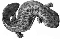 | 1.2 | |||
| *Kamo Giant Camphor tree Cinnamomum camphora 加茂の大クス Kamo no ō-kusu | Higashimiyoshi |  | 34°02′27″N133°55′55″E / 34.04091°N 133.93190°E | 2.1 | ||
| Japanese dormouse Glirulus japonicus ヤマネ Yamane | found in Honshū, Shikoku, and Kyūshū |  | 1.1 | |||
| Brent goose Branta bernicla コクガン Kokugan |  | 1.2 | ||||
| Bean goose Anser fabalis ヒシクイ Hishikui |  | 1.2 | ||||
| Greater white-fronted goose Anser albifrons マガン Magan |  | 1.2 | ||||
| Haha River Giant mottled eel Habitat Anguilla marmorata 母川オオウナギ生息地 Haha-gawa ōunagi seisoku-chi | Kaiyō |  | 33°35′52″N134°20′33″E / 33.59769°N 134.34260°E | 1.3 | ||
| Ōhama Beach Sea turtles and their Egg-laying Grounds Chelonioidea 大浜海岸のウミガメおよびその産卵地 Ōhama kaigan no umigame oyobi sono sanran-chi | Minami |  | 33°43′57″N134°32′38″E / 33.73263°N 134.54390°E | 1.2 | ||
| Misato Fireflies and their Area of Incidence Lampyridae 美郷のホタルおよびその発生地 Misato no hotaru oyobi sono hassei-chi | Yoshinogawa |  | 34°00′46″N134°16′28″E / 34.01281°N 134.27440°E | 1.3 | ||
| Akabane Taishi Chinese hackberry Celtis sinensis 赤羽根大師のエノキ Akabane Taishi no enoki | Tsurugi |  | 33°57′07″N134°04′11″E / 33.95206°N 134.06960°E | 2.1 | ||
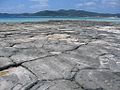
| Awa Sand Pillars 阿波の土柱 Awa no dochū | Awa |  | 34°05′34″N134°12′25″E / 34.09278°N 134.20690°E | 3.9 | ||
| Sakashū Irregular Strata 坂州不整合 Sakashū fuseigō | Naka | 33°49′40″N134°17′55″E / 33.82767°N 134.29870°E | 3.1,2,7 | |||
| Sawatani Thismia abei Area of Incidence 沢谷のタヌキノショクダイ発生地 Sawatani no tanukinoshokudai hassei-chi | Naka | 33°51′58″N134°15′47″E / 33.86603°N 134.26300°E | 2.12 | |||
| Shishikui Bay Fossil Ripples 宍喰浦の化石漣痕 Shishikui-ura no kaseki renkon | Kaiyō |  | 33°33′36″N134°18′40″E / 33.55993°N 134.31110°E | 3.1 | ||
| Mount Suzu Mitrastemonaceae Area of Incidence 鈴が峯のヤッコソウ発生地 Suzu-ga-mine no yakkosō hassei-chi | Kaiyō |  | 33°34′46″N134°17′41″E / 33.579522°N 134.294758°E | 2.12 | ||
| Tsu-shima Temperate Plant Communities 津島暖地性植物群落 Tsu-shima danchi-sei shokubutsu gunraku | Mugi | 33°38′19″N134°26′52″E / 33.63859°N 134.44780°E | 2.2 | |||
| Deba-jima Ōike Lamprothamnium succinctum Native Area 出羽島大池のシラタマモ自生地 Deba-jima Ōike no shiratamamo jisei-chi | Mugi | 33°37′54″N134°25′22″E / 33.63162°N 134.42270°E | 2.10 | |||
| Nyūbo Jinja Ginkgo Ginkgo biloba 乳保神社のイチョウ Nyūbo Jinja no ichō | Kamiita |  | 34°05′59″N134°23′55″E / 34.09965°N 134.39850°E | 2.1 | ||
| Nogami Giant Chinaberry tree Melia azedarach 野神の大センダン Nogami no dai-sendan | Awa |  | 34°05′07″N134°15′08″E / 34.08515°N 134.25210°E | 2.1 | ||
| Funakubo Rhododendron Communities Rhododendron weyrichii 船窪のオンツツジ群落 Funakubo no ontsutsuji gunraku | Yoshinogawa | 34°00′09″N134°11′50″E / 34.00254°N 134.19720°E | 2.4 | |||
| Benten-jima Tropical Plant Communities 弁天島熱帯性植物群落 Benten-jima nettaisei shokubutsu gunraku | Anan | 33°52′22″N134°39′29″E / 33.87272°N 134.65800°E | 2.2,10 | |||
| Ōboke-Koboke 大歩危 小歩危 Ōboke・Koboke | Miyoshi |  | 33°53′12″N133°45′38″E / 33.886667°N 133.760556°E | |||
| Miune-Tenguzuka Miyama kumazasa and Rhododendron tschonoskii Communities 三嶺・天狗塚のミヤマクマザサ及びコメツツジ群落 Miune・Tenguzuka no miyama-kuma-zasa oyobi kometsutsuji gunraku | Miyoshi | designation includes areas of Kami in Kōchi Prefecture |  | 33°50′26″N133°58′48″E / 33.84052°N 133.98000°E | 2.2 | |
![]() April 2021
April 2021