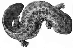
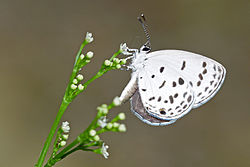
Monument Municipality Comments Image Coordinates Type Ref. *Japanese serow Capricornis crispus カモシカ Kamoshika designated across twenty-nine prefectures 1.1 *Japanese giant salamander Andrias japonicus オオサンショウウオ Õsanshōuo designated across eighteen prefectures 1.2 *Kasugayama Primeval Forest 春日山原始林 Kasuga-yama genshi-rin Nara no tree-felling or hunting has been permitted since 841; inscribed on the UNESCO World Heritage List as one of the Historic Monuments of Ancient Nara [ 6] 34°40′55″N 135°51′30″E / 34.6820741°N 135.85831576°E / 34.6820741; 135.85831576 (Ischikauia in Kagami-ike at Tōdaiji ) 2.2 Deer in Nara 奈良のシカ Nara no shika Nara 1.3 Japanese dormouse Glirulus japonicus ヤマネ Yamane found in Honshū, Shikoku, and Kyūshū 1.1 Moore's Cupid Shijimia moorei ゴイシツバメシジミ Goishitsubame-shijimi 1.1 Arhopala ganesa Habitat ルーミスシジミ 生息地 Rūmisu-shijimi seisokuchi Nara 34°41′19″N 135°51′50″E / 34.68849°N 135.86380°E / 34.68849; 135.86380 (Clematis patens Habitat ) 1.2 Verdure on Mount Imo 妹山樹叢 Imo-yama jusō Yoshino 34°23′38″N 135°52′15″E / 34.39376°N 135.87080°E / 34.39376; 135.87080 (Verdure on Mount Imo ) 2.1 Siebold's magnolia HabitatMagnolia sieboldii ssp. japonica オオヤマレンゲ自生地 ōyamarenge jiseichi Tenkawa , Gojō 34°10′26″N 135°54′15″E / 34.17386°N 135.90410°E / 34.17386; 135.90410 (Siebold's magnolia Habitat ) 2.2 Clematis patens Habitat カザグルマ 自生地 Kazaguruma jiseichi Uda 34°29′34″N 135°55′57″E / 34.49275°N 135.93250°E / 34.49275; 135.93250 (Clematis patens Habitat ) 2.11 Asian Bayberry Forest in the Precinct of Kasuga Jinja Nageia nagi 春日神社境内ナギ樹林 Kasuga Jinja keidai nagi ju-rin Nara 34°40′53″N 135°50′56″E / 34.68147°N 135.84880°E / 34.68147; 135.84880 (Asian Bayberry Forest in the Precinct of Kasuga Jinja ) 2.2 Sannokō River Japanese Douglas-fir Primeval ForestPseudotsuga japonica 三ノ公川トガサワラ原始林 Sannokō-gawa togasawara genshi-rin Kawakami 34°16′01″N 136°04′20″E / 34.26705°N 136.07210°E / 34.26705; 136.07210 (Sannokō River Japanese Douglas-fir Primeval Forest ) 2.2 Lysionotus Communities シシンラン群落 Shishinran gunraku Kamikitayama 34°09′00″N 136°00′41″E / 34.14989°N 136.01140°E / 34.14989; 136.01140 (Lysionotus Communities ) 2.9 Chisoku-in Naranoyaezakura Prunus verecunda 'Antiqua' 知足院 ナラノヤエザクラ Chisokuin naranoyaezakura Nara 34°41′32″N 135°50′25″E / 34.69236°N 135.84020°E / 34.69236; 135.84020 (Chisoku-in Naranoyaezakura ) 2.1 Niukawakami Jinja Myrsine stolonifera Habitat 丹生川上中社のツルマンリョウ自生地 Niukawakami nakasha no tsurumanryō jiseichi Higashiyoshino 34°23′26″N 135°59′12″E / 34.39053°N 135.98670°E / 34.39053; 135.98670 (Niukawakami Jinja Myrsine stolonifera Habitat ) 2.2,10 Hayama Lily of the Valley CommunitiesConvallaria majalis 吐山スズラン群落 Hayama suzuran gunraku Nara 34°33′42″N 135°57′21″E / 34.56177°N 135.95570°E / 34.56177; 135.95570 (Hayama Lily of the Valley Communities ) 2.10 Byōbu-iwa, Kabuto-iwa, and Yoroi-iwa屏風岩、兜岩および鎧岩 Byōbu-iwa, Kabuto-iwa oyobi Yoroi-iwa Soni 34°31′39″N 136°07′26″E / 34.5274°N 136.1239°E / 34.5274; 136.1239 (Byōbu-iwa, Kabuto-iwa, and Yoroi-iwa ) Futami Giant Muku Tree Aphananthe aspera 二見の大ムク Futami no ōmuku Gojō 34°20′39″N 135°41′12″E / 34.34406°N 135.68680°E / 34.34406; 135.68680 (Futami Giant Muku Tree ) 2.1 Mount Bukkyō Primeval Forest仏経嶽原始林 Bukkyōgatake genshi-rin Kamikitayama , Tenkawa 34°10′21″N 135°54′33″E / 34.17262°N 135.90910°E / 34.17262; 135.90910 (Mount Bukkyō Primeval Forest ) 2.2 Mukō Lily of the Valley CommunitiesConvallaria majalis 向淵スズラン群落 Mukō suzuran gunraku Uda 34°34′39″N 135°58′52″E / 34.57758°N 135.98120°E / 34.57758; 135.98120 (Mukō Lily of the Valley Communities ) 2.10 Murō Mountain Temperate Fern CommunitiesConvallaria majalis 室生山暖地性シダ群落 Murō-zan danchisei shida gunraku Uda 34°32′23″N 136°02′24″E / 34.53980°N 136.03990°E / 34.53980; 136.03990 (Murō Mountain Temperate Fern Communities ) Yatsubusa Sugi Cryptomeria japonica 八ツ房スギ Yatsubusa-sugi Uda 34°26′36″N 135°58′36″E / 34.44324°N 135.97680°E / 34.44324; 135.97680 (Yatsubusa Sugi ) 2.1 Mount Yoki Subtropical Forest 与喜山暖帯林 Yoki-san dantai-rin Sakurai 34°32′18″N 135°54′42″E / 34.53824°N 135.91160°E / 34.53824; 135.91160 (Mount Yoki Subtropical Forest ) 2.1 Dorohatchō 瀞八丁 Õsanshōuo Totsukawa designation includes areas of Kumano in Mie Prefecture and Shingū in Wakayama Prefecture ; also a Special Place of Scenic Beauty 33°54′02″N 135°53′10″E / 33.90065°N 135.88600°E / 33.90065; 135.88600 (Dorohatchō )