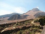
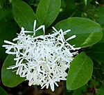
Monument Municipality Comments Image Coordinates Type Ref. Tsushima Yamaneko Prionailurus bengalensis euptilurus ツシマヤマネコ Tsushima yamaneko Tsushima 34°12′N 129°14′E / 34.20°N 129.24°E / 34.20; 129.24 (Tsushima Yamaneko ) 1.1 Tsushima Marten Martes melampus tsuensis ツシマテン Tsushima ten Tsushima 34°12′N 129°14′E / 34.20°N 129.24°E / 34.20; 129.24 (Tsushima Marten ) 1.1 Japanese Dormouse Glirulus japonicus ヤマネ Yamane 1.1 Japanese Wood Pigeon Columba janthina カラスバト Karasubato 1.2 Ajika-jima 阿値賀島 Ajika-jima Hirado 33°15′02″N 129°20′21″E / 33.25054°N 129.33930°E / 33.25054; 129.33930 (Ajika-jima ) Ikenohara Kyushu Azalea CommunitiesRhododendron kiusianum 池の原ミヤマキリシマ 群落 Ikenohara miyama kirishima gunraku Unzen 32°44′41″N 130°16′09″E / 32.74474°N 130.26920°E / 32.74474; 130.26920 (Ikenohara Kyushu Azalea Communities ) 2.4 Isahaya City Castle Mountain Temperate Verdure諫早市城山暖地性樹叢 Isahaya-shi shiroyama danchi seijusō Isahaya 32°50′43″N 130°02′51″E / 32.84519°N 130.04740°E / 32.84519; 130.04740 (Isahaya City Castle Mountain Temperate Verdure ) 2.2 Mount Iwato Verdure岩戸山樹叢 Iwato-yama jusō Minamishimabara 32°37′30″N 130°09′22″E / 32.62488°N 130.15600°E / 32.62488; 130.15600 (Mount Iwato Verdure ) 2.2 Giant Mottled Eel HabitatAnguilla marmorata オオウナギ生息地 Ōunagi seisokuchi Nagasaki 32°33′46″N 129°47′00″E / 32.56267°N 129.78320°E / 32.56267; 129.78320 (Giant Mottled Eel Habitat ) 1.3 Ōmura Jinja Ōmura CherryPrunus 大村神社 のオオムラザクラ Ōmura Jinja no Ōmura-zakura Ōmura 32°53′52″N 129°57′26″E / 32.89766°N 129.95720°E / 32.89766; 129.95720 (Ōmura Jinja Ōmura Cherry ) 2.1 Ōmura Red-bark Oak Natural ForestQuercus gilva 大村のイチイガシ天然林 Ōmura no ichiigashi tennen-rin Ōmura 32°56′22″N 130°00′00″E / 32.93956°N 130.00000°E / 32.93956; 130.00000 (Ōmura Red-bark Oak Natural Forest ) 2.2 Ohashi Kannon Fern Plant CommunitiesPteridopsida 御橋観音シダ植物群落 Ohashi Kannon shida shokubutsu gunraku Sasebo 33°16′22″N 129°42′04″E / 33.27273°N 129.70110°E / 33.27273; 129.70110 (Ohashi Kannon Fern Plant Communities ) 2.9,10 Balanophora tobiracola Native Northern Limitキイレツチトリモチ自生北限地 Kiiretsuchitorimochi jisei hoku genchi Nagasaki 32°45′21″N 129°54′09″E / 32.75585°N 129.90250°E / 32.75585; 129.90250 (Balanophora tobiracola Native Northern Limit ) 2.10 Kuroko-jima Primeval Forest黒子島原始林 Kuroko-jima genshi-rin Hirado 33°22′24″N 129°33′43″E / 33.37334°N 129.56200°E / 33.37334; 129.56200 (Kuroko-jima Primeval Forest ) 2.2 Gensei-numa Marshland Plant Communities原生沼沼野植物群落 Gensei-numa shōya shokubutsu gunraku Unzen 32°44′26″N 130°15′30″E / 32.74047°N 130.25830°E / 32.74047; 130.25830 (Gensei-numa Marshland Plant Communities ) 2.6 Konagai Magnolia compressa 小長井のオガタマノキ Konagai no ogatamanoki Isahaya 32°55′57″N 130°09′08″E / 32.93254°N 130.15230°E / 32.93254; 130.15230 (Konagai Magnolia compressa ) 2.1 Jigoku Zone Enkianthus cernuus Communities地獄地帯シロドウダン群落 Jigoku chitai shirodoudan gunraku Unzen 32°44′26″N 130°15′51″E / 32.74053°N 130.26410°E / 32.74053; 130.26410 (Jigoku Zone Enkianthus cernuus Communities ) 2.2 Mount Sumoshira Primeval Forest洲藻白岳原始林 Sumoshira-take genshi-rin Tsushima 34°15′40″N 129°15′07″E / 34.26121°N 129.25190°E / 34.26121; 129.25190 (Mount Sumoshira Primeval Forest ) 2.2 Tatsunoshima Coastal Plant Communities辰の島海浜植物群落 Tatsunoshima kaihin shokubutsu gunraku Iki 33°52′02″N 129°40′40″E / 33.86734°N 129.67790°E / 33.86734; 129.67790 (Tatsunoshima Coastal Plant Communities ) 2.5 Mount Tatera Primeval Forest龍良山原始林 Tatera-yama genshi-rin Tsushima 34°08′31″N 129°13′33″E / 34.14204°N 129.22590°E / 34.14204; 129.22590 (Mount Tatera Primeval Forest ) 2.2 Mount Tara Rhododendron japonoheptamerum Grouping 多良岳 ツクシシャクナゲ 群叢 Tara-dake tsukushi shakunage gunsō Isahaya 32°57′58″N 130°05′24″E / 32.96616°N 130.09000°E / 32.96616; 130.09000 (Mount Tara Rhododendron japonoheptamerum Grouping ) 2.2 Danjo Islands 男女群島 Danjo-guntō Gotō 31°59′16″N 128°20′54″E / 31.9877°N 128.3484°E / 31.9877; 128.3484 (Danjo Islands ) Nanatsugama Limestone Cave 七釜鍾乳洞 Nanatsugama shōnyūdō Saikai 33°01′32″N 129°39′44″E / 33.02542°N 129.66230°E / 33.02542; 129.66230 (Nanatsugama Limestone Cave ) 3.6 Narao Sea Fig Ficus superba 奈良尾のアコウ Narao no akō Shin-Kamigotō 32°50′23″N 129°03′35″E / 32.8398°N 129.0597°E / 32.8398; 129.0597 (Narao Sea Fig ) 2.1 Naru Island Mount Gongen VerdureFicus superba 奈留島権現山樹叢 Narushima Gongen-yama jusō Gotō 32°49′32″N 128°56′19″E / 32.82561°N 128.93850°E / 32.82561; 128.93850 (Naru Island Mount Gongen Verdure ) 2.2 Mount No Japanese Holly CommunitiesIlex crenata 野岳イヌツゲ群落 No-dake inutsuge gunraku Unzen 32°44′38″N 130°17′20″E / 32.74402°N 130.28900°E / 32.74402; 130.28900 (Mount No Japanese Holly Communities ) 2.2 Hijikuro River Nemalionopsis tortuosa Site of Incidence土黒川のオキチモズク 発生地 Hijikuro-gawa no okichimozuku hassei-chi Unzen 32°50′53″N 130°17′37″E / 32.84814°N 130.29360°E / 32.84814; 130.29360 (Hijikuro River Nemalionopsis tortuosa Site of Incidence ) 2.8 Hirado Conglomerate Rock Plant Communities平戸礫岩の岩石地植物群落 Hirado tsubute-iwa no ganseki-chi shokubutsu gunraku Hirado 33°14′09″N 129°23′59″E / 33.23594°N 129.39980°E / 33.23594; 129.39980 (Hirado Conglomerate Rock Plant Communities ) 2.3,10 Fugen-dake Autumn Colour Forest普賢岳紅葉樹林 Fugen-dake kōyō jurin Unzen 32°45′36″N 130°17′42″E / 32.75992°N 130.29510°E / 32.75992; 130.29510 (Fugen-dake Autumn Colour Forest ) 2.2 Heisei Shinzan 平成新山 Heisei-shinzan Shimabara , Unzen 32°45′41″N 130°17′56″E / 32.76139°N 130.29880°E / 32.76139; 130.29880 (Heisei Shinzan ) 3.10 Madara Island Pothole 斑島 玉石甌穴 Madara-jima tamaishi ōketsu Ojika 33°12′45″N 129°01′29″E / 33.21241°N 129.02460°E / 33.21241; 129.02460 (Madara Island Pothole ) 3.9 Mitake Bird Breeding Grounds御岳鳥類繁殖地 Mitake chōrui hanshoku-chi Tsushima 34°34′17″N 129°22′44″E / 34.57126°N 129.37880°E / 34.57126; 129.37880 (Mitake Bird Breeding Grounds ) 1.2 Meotoki Giant Japanese Cedar Cryptomeria japonica 女夫木の大スギ Meotoki no ō-sugi Isahaya 32°48′59″N 130°04′00″E / 32.81639°N 130.06680°E / 32.81639; 130.06680 (Meotoki Giant Japanese Cedar ) 2.1 Waniura Chinese Fringetree Native SpotChionanthus retusus 鰐浦ヒトツバタゴ自生地 Waniura hitotsubatago jisei-chi Tsushima 34°41′22″N 129°26′32″E / 34.68946°N 129.44220°E / 34.68946; 129.44220 (Waniura Chinese Fringetree Native Spot ) 2.10 Cyathea spinulosa Northern Native Range ヘゴ 自生北限地帯 Hego jisei hoku genchi-tai Gotō 32°39′43″N 128°46′45″E / 32.66186°N 128.77922°E / 32.66186; 128.77922 (Cyathea spinulosa Northern Native Range ) 2.10