This is a list of all known Roman sites within the county of Lincolnshire.
This is a list of all known Roman sites within the county of Lincolnshire.
| Name | Roman Name | Type | Location | Coordinates | Dates | Notes | Image |
|---|---|---|---|---|---|---|---|
| Alkborough | Aquis | Fortified Settlement | Alkborough | ||||
| Ancaster | ? | Fortified Settlement | Ancaster | ||||
| Brant Broughton | Briga | Settlement | Brant Broughton | ||||
| Broughton | Praetorium | Broughton | |||||
| Caistor | ? | Fortified Settlement | Caistor | ||||
| Dragonby | ? | Settlement | Dragonby | ||||
| Great Casterton | ? | Fortified Settlement | Great Casterton, Rutland | Though the settlement is in Rutland, it is also the location where Ermine Street crossed the River Gwash close to the modern boundary between Rutland and Lincolnshire. | |||
| Hibaldstow | ? | Settlement | Hibaldstow | ||||
| Horncastle | Bannovalum? | Fortified Settlement | Horncastle | ||||
| Kirmington | ? | Fortified Settlement | Kirmington | On site of earlier Iron Age fortified settlement. | |||
| Kirton in Lindsey | Inmedio | Settlement | Kirton in Lindsey | ||||
| Lincoln | Lindum Colonia | Colonia/Legionary Fortress | Lincoln | ||||
| Louth | Luda | Settlement | Louth | ||||
| Ludford | ? | Settlement | Ludford | ||||
| Marton | ? | Fort | Marton | On Till Bridge Lane next to its crossing of the River Trent. | |||
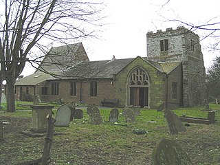
| Navenby | ? | Settlement | Navenby | Sits upon Ermine Street. Evidence of Bronze and Iron Age activity. | 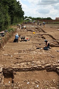 | ||
| Owmby | ? | Settlement | Owmby | ||||
| Saltersford | Causennis? | Settlement | Little Ponton and Stroxton | ||||
| Sapperton | Causennis? | Fortified Settlement | Sapperton | ||||
| Sleaford | Bannovalum? | Settlement | Sleaford | ||||
| Stow | Sidnacester | Settlement | Stow | ||||
| Tattershall | Drurobrivis | Settlement | Tattershall | ||||
| Torksey | Tiovulfingacester | Settlement | Torksey | ||||
| Wainfleet | Vainona | Settlement | Wainfleet | ||||
| Ulceby Cross | ? | Settlement | Ulceby | ||||
| Willoughby | Verometum | Settlement | Willoughby | ||||
| Winteringham | Ad Abum | Settlement | Winteringham |
| Name | Roman Name | Type | Location | Coordinates | Dates | Notes | Image |
|---|---|---|---|---|---|---|---|
| Barrs Farm Villa | ? | Villa | Hemingby | TF24157331 | Historic England. "Monument No. 352988". Research records (formerly PastScape). | ||
| Baths | ? | Baths | Lincoln (Steep Hill/Danes Terrace) | ||||
| Baumber Cursus | ? | Cursus | Baumber | Possible Roman cursus | |||
| Bourne-Morton Canal | ? | Canal | Between Bourne and Morton | Only traceable through crop-marks. | |||
| Car Dyke | ? | Canal | Western Edge of The Fens | 85 miles long |  | ||
| Castellum Aquæ | ? | Water Tank | Lincoln (East Bight) | ||||
| Denton Villa | ? | Villa | Denton | SK87593094 | Historic England. "Monument No. 323786". Research records (formerly PastScape). | ||
| East Gate | ? | Gate | Lincoln (Eastgate) |  | |||
| Ermine Street | ? | Road | Between London and York, via Stamford, Grantham, Ancaster, Lincoln, Scunthorpe |  | |||
| Forum | ? | Forum | Lincoln (Bailgate) | Granite stones mark locations of the now subsurface columns. |  | ||
| Foss Dyke | ? | Canal | Between Lincoln and Torksey | c.120AD | |||
| Fosse Way | ? | Road | Between Exeter and Lincoln | 230 miles in length | 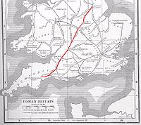 | ||
| Glentworth Hall Villa | ? | Villa | Glentworth | SK94378828 | Historic England. "Monument No. 920235". Research records (formerly PastScape). | ||
| Gravel Pit Farm Villa | ? | Villa | Kirton in Lindsey | SK939966 | Historic England. "Monument No. 1063122". Research records (formerly PastScape). | ||
| Gravestone | ? | Gravestone | Lincoln (St Mary le Wigford) | Reused by the Danes. Now set in the wall of the Norman tower. |  | ||
| Haceby Villa | ? | Villa | Haceby | TF01953692 | Historic England. "Monument No. 348661". Research records (formerly PastScape). | ||
| High Street | ? | Road | Between Horncastle and Caistor, via Baumber. Possibly on to The Humber. | Ancient Ridgeway used and straightened by the Romans. | |||
| Horkstow Villa | ? | Villa | Horkstow | SE98491914 | Historic England. "Monument No. 63618". Research records (formerly PastScape). | ||
| King Street | ? | Road | Between Peterborough and Ancaster via Bourne and Sapperton. | ||||
| Kirmond le Mire Villa | ? | Villa | Kirmond le Mire | TF183930 | Historic England. "Monument No. 893061". Research records (formerly PastScape). | ||
| Lady Well | ? | Natural Spring | Ancaster | Reputedly the water-source for Roman Ancaster. | |||
| Lead Coffin | ? | Coffin (Lead) | Baumber (Churchyard) | Found in Baumber churchyard in 1892. | |||
| Mareham Lane | ? | Road | Between Bourne and Sleaford, and possibly on to Lincoln. | | |||
| Mere Balk Lane | ? | Road | Between Stixwould and Saltfleetby, via Hemingby and Tathwell. | Reputedly of Roman Origin due to its straightness. |  | ||
| Milestone | ? | Milestone | Lincoln (St Mary's Guildhall) | First Milestone south of Roman Lincoln. | |||
| Mint Wall | ? | Basicalla | Lincoln (West Bight) |  | |||
| Mount Pleasant Farm Villa | ? | Villa | Kirton in Lindsey | SE93940038 | Historic England. "Monument No. 63566". Research records (formerly PastScape). | ||
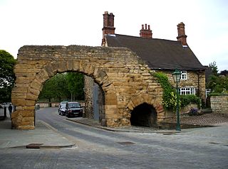
| Newport Arch | ? | Gate | Lincoln | 3rd century | Reputedly the oldest arch in the United Kingdom still used by traffic |  | |
| Norton Disney Villa | ? | Villa | Norton Disney | SK85896028 | Historic England. "Monument No. 324486". Research records (formerly PastScape). | ||
| Owmby | ? | Settlement | Owmby | ||||
| Posterngate | ? | Gate | Lincoln (Saltersgate) | Under RBS Bank. Limited public access. |  | ||
| Riseholme Barrow | ? | Burial Barrow | Riseholme | 1st century | |||
| Roxby Villa | ? | Villa | Roxby | SE92031697 | Historic England. "Monument No. 63684". Research records (formerly PastScape). | ||
| Scampton Villa | ? | Villa | Scampton | SK95527847 | Historic England. "Monument No. 326410". Research records (formerly PastScape). | ||
| South Gate (Upper) | ? | Gate | Lincoln (Steep Hill) | Fragments between numbers 25 and 26, and within 44, Steep Hill. |  | ||
| St Paul in the Bail | ? | Church | Lincoln (Bailgate) | 4th century |  | ||
| Stainby Villa | ? | Villa | Stainby | SK921222 | Historic England. "Monument No. 325510". Research records (formerly PastScape). | ||
| Stoke Rochford Villa | ? | Villa | Stoke Rochford | SK9328 | Historic England. "Monument No. 325445". Research records (formerly PastScape).; Historic England. "Monument No. 325448". Research records (formerly PastScape). | ||
| Sudbrooke Villa | ? | Villa | Sudbrooke | TF037765 | Excavated since 2005 [1] | ||
| Till Bridge Lane | ? | Road | Between Ermine Street north of Lincoln and York, via Doncaster, Castleford and Tadcaster. | ||||
| Walesby Villa | ? | Villa | Walesby | TF14739262 | Historic England. "Monument No. 351895". Research records (formerly PastScape). | ||
| Wall | ? | City Wall | Lincoln | Surviving fragments throughout the city. |  | ||
| Wall | ? | Town Wall | Horncastle | Surviving fragments throughout the town. |  | ||
| Winterton Villa | ? | Villa | Winterton | SE90961799 | Historic England. "Monument No. 63693". Research records (formerly PastScape). | ||
| Well | ? | Well | Lincoln (Bailgate) | Next to St Paul in the Bail, now covered with glass screen. In use until the 17th century. |  | ||
| West Gate (Lower) | ? | Gate | Lincoln (Orchard Street) | 3rd century | 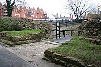 | ||
| West Gate (Upper) | ? | Gate | Lincoln (Westgate) | No remains currently visible. |  |

Lincoln is a cathedral city and district in Lincolnshire, England, of which it is the county town. In the 2021 Census, the Lincoln district had a population of 103,813. The 2011 census gave the urban area of Lincoln, including North Hykeham and Waddington, a population of 115,000, a figure which has been updated to 127,540 with the 2021 census.

Lincolnshire is a ceremonial county in eastern England. It borders the East Riding of Yorkshire across the Humber estuary to the north, the North Sea to the east, Norfolk, Cambridgeshire, Northamptonshire and Rutland to the south, and Leicestershire, Nottinghamshire and South Yorkshire to the west. The county town is the city of Lincoln.
Ermine Street is a major Roman road in England that ran from London (Londinium) to Lincoln and York (Eboracum). The Old English name was Earninga Strǣt (1012), named after a tribe called the Earningas, who inhabited a district later known as Armingford Hundred, around Arrington, Cambridgeshire, and Royston, Hertfordshire. "Armingford", and "Arrington" share the same Old English origin. The original Celtic and Roman names for the route remain unknown. It is also known as the Old North Road from London to where it joins the A1 Great North Road near Godmanchester.

North Thoresby is a village and civil parish in the East Lindsey district of Lincolnshire, England. It is situated between Louth and Grimsby, approximately 7.5 miles (12 km) from each. and has a village population of 1,068 (2011) Some 50.5% of the population is older than 60 years.

Skegness is a seaside town and civil parish in the East Lindsey District of Lincolnshire, England. On the Lincolnshire coast of the North Sea, the town is 43 miles (69 km) east of Lincoln and 22 miles (35 km) north-east of Boston. With a population of 19,579 as of 2011, it is the largest settlement in East Lindsey. It also incorporates Winthorpe and Seacroft, and forms a larger built-up area with the resorts of Ingoldmells and Chapel St Leonards to the north. The town is on the A52 and A158 roads, connecting it with Boston and the East Midlands, and Lincoln respectively. Skegness railway station is on the Nottingham to Skegness line.

Horncastle is a market town and civil parish in the East Lindsey district in Lincolnshire, England. It is 17 miles (27 km) east of Lincoln. Its population was 6,815 at the 2011 census and estimated at 7,123 in 2019. A section of the ancient Roman walls remains.

Winterton is a town in North Lincolnshire, England, 5 miles (8 km) north-east of Scunthorpe. The 2021 census found 4,765 inhabitants living in the town. Winterton is located near the banks of the Humber and is 8 miles (13 km) south-west of the Humber Bridge which can be seen from many parts of the town.

Caistor is a town and civil parish in the West Lindsey district of Lincolnshire, England. As its name implies, it was originally a Roman castrum or fortress. It lies at the north-west edge of the Lincolnshire Wolds, on the Viking Way, and just off the A46 between Lincoln and Grimsby, at the A46, A1084, A1173 and B1225 junction. It has a population of 2,601. Its name comes from the Anglo-Saxon ceaster and was given in the Domesday Book as Castre.
Mablethorpe is a seaside town in the East Lindsey district of Lincolnshire, England, part of the civil parish of Mablethorpe and Sutton. The population including nearby Sutton-on-Sea was 12,531 at the 2011 census and estimated at 12,633 in 2019. The town was visited regularly by Alfred, Lord Tennyson, a 19th-century Poet Laureate of the United Kingdom. Some town features have been named after him, such as Tennyson Road and the now closed Tennyson High School.
Lincolnshire, England derived from the merging of the territory of the ancient Kingdom of Lindsey with that controlled by the Danelaw borough Stamford. For some time the entire county was called 'Lindsey', and it is recorded as such in the Domesday Book. Later, Lindsey was applied to only the northern core, around Lincoln; it was defined as one of the three 'Parts of Lincolnshire', along with Holland in the south-east and Kesteven in the south west.
Lincolnshire is a large county in England with a sparse population distribution, which leads to problems funding all sorts of transport. The transport history is long and varied, with much of the road network still based on the Roman model, and the once extensive rail network a shadow of its former self.

Wainfleet All Saints is an ancient port and market town on the east coast of England, in the East Lindsey district of Lincolnshire, on the A52 road 5 miles (8 km) south-west of Skegness and 14 miles (23 km) north-east of Boston. It stands on two small rivers, the Steeping and Limb, that form Wainfleet Haven. The town is close to the Lincolnshire Wolds. The village of Wainfleet St Mary is to the south.
Lindum Colonia was the Latin name for the settlement which is now the City of Lincoln in Lincolnshire. It was founded as a Roman Legionary Fortress during the reign of the Emperor Nero or possibly later. Evidence from Roman tombstones suggests that Lincoln was first garrisoned by the Ninth Legion Hispana, which probably moved from Lincoln to found the fortress at York around c. 71 AD. Lindum was then garrisoned by the Second Legion Adiutrix, which then went on to Chester in 77–78 AD.

Maidenwell is a village and civil parish in the East Lindsey district of Lincolnshire, England. The village is 6 miles (10 km) south from Louth. Maidenwell population is included in the civil parish of Burwell. The parish includes the village of Ruckland, the hamlets of Oxcombe, Farforth, and Worlaby.

Ingoldmells is a coastal village, civil parish and resort in the East Lindsey district of Lincolnshire, England. It is situated on the A52, and 3 miles (5 km) north from the resort town of Skegness.

Burgh le Marsh is a town, and electoral ward in the East Lindsey district of Lincolnshire, England.
Navenby is a village and civil parish in the North Kesteven district of Lincolnshire, England. Lying 8 miles (13 km) south from Lincoln and 9 miles (14 km) north-northwest from Sleaford, Navenby had a population of 2,128 in the 2011 census and in March 2011, it was named as the 'Best Value Village' in England following a national survey.

Fulletby is a village and a civil parish in the East Lindsey district of Lincolnshire, England. It is in the Lincolnshire Wolds, and 3 miles (5 km) north-east from Horncastle, 9 miles (14 km) south from Louth, and 8 miles (13 km) north-west from Spilsby. The parish covers approximately 1,950 acres (8 km2). At the time of the 2011 census the population remained less than 100 and is included in the civil parish of Low Toynton.

Kesteven County Council was the county council of Kesteven, one of the three Parts of Lincolnshire in eastern England. It came into its powers on 1 April 1889 and was abolished on 1 April 1974. The county council was based at the County Offices in Sleaford. It was amalgamated with Holland County Council and Lindsey County Council to form the new Lincolnshire County Council in 1974.

Market Stainton is a village and civil parish in the East Lindsey district of Lincolnshire, England. It is situated approximately 7 miles (11 km) north from the market town of Horncastle.