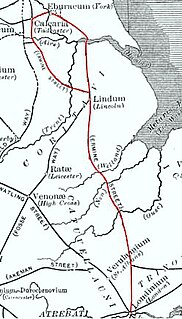
Ermine Street is the name of a major Roman road in England that ran from London (Londinium) to Lincoln and York (Eboracum). The Old English name was "Earninga Straete" (1012), named after a tribe called the Earningas, who inhabited a district later known as Armingford Hundred, around Arrington, Cambridgeshire and Royston, Hertfordshire. "Armingford", and "Arrington" share the same Old English origin. The original Celtic and Roman names for the route remain unknown. It is also known as the Old North Road from London to where it joins the A1 Great North Road near Godmanchester.

The A15 is a major road in England. It runs north from Peterborough via Market Deeping, Bourne, Sleaford and Lincoln along a variety of ancient, Roman, and Turnpike alignments before it is interrupted at its junction with the M180 near Scawby. The road restarts 10 miles (16 km) east, and then continues north past Barton-upon-Humber, crossing the Humber on the Humber Bridge before terminating at Hessle near Kingston upon Hull.

Ancaster is a village and civil parish in the South Kesteven district of Lincolnshire, England, on the site of a Roman town. The population of the civil parish was 1,317 at the 2001 census increasing to 1,647 at the 2011 census. The civil parish includes the settlements of Sudbrook and West Willoughby.

Bracebridge Heath is a commuter village located approximately 2 miles (3 km) south from the city and county town of Lincoln, England. It lies at the junction of two major roads the A15 to Sleaford and the A607 to Grantham, and was part of the Boothby Graffoe Wapentake. The village sits on top of Lincoln Cliff, overlooking Lincoln and the valley of the River Witham. The Viking Way runs along the cliff top, a 147 miles (237 km) long footpath, which runs from the Humber Bridge to Oakham. Its population at the 2001 census was 4,530, increasing to 5,656 at the 2011 census.

Threekingham is a village in the North Kesteven district of Lincolnshire, England. The population of the civil parish at the 2011 census was 233. It is situated on the A52 Grantham to Boston road, 6 miles (10 km) south from Sleaford, and close to the A15 Threekingham Bar roundabout. Mareham Lane, the Roman Road aligned with King Street, crosses the A15 at Threekingham.
Dowsby is a village and civil parish in the South Kesteven district of Lincolnshire, England. It is situated on the western edge of The Fens at the junction of the east-west B1397 road and the north-south B1177. It is 1 mile (1.6 km) north-east from Rippingale and just south of Pointon. The civil parish includes the hamlet of Graby. Nearby to the east, along the B1397 at Dowsby Fen, is Car Dyke. The civil parish population taken at the 2011 census was 204.

Aslackby and Laughton is a civil parish in the South Kesteven district of Lincolnshire, England. According to the 2001 census the parish had a population of 243, in 102 households. increasing slightly to 251 in 118 households at the 2011 census. It consists of the village of Aslackby, the hamlet of Laughton, and scattered farms.

Billingborough is a village and civil parish in the South Kesteven district of Lincolnshire, England. It is situated approximately 10 miles (16 km) north of Bourne and 10 miles south of Sleaford, and on the B1177 between Horbling and Pointon just south of the A52.

Burton Pedwardine is a hamlet and civil parish in the district of North Kesteven, Lincolnshire, England. The population at the 2011 census was 187. The hamlet is situated approximately 4 miles (6 km) south-east from the market town of Sleaford and south-west of the village of Heckington.

Horbling is a village and civil parish in the South Kesteven district of Lincolnshire, England. It lies on the B1177, 7 miles (11 km) south-east of Sleaford, 14.5 miles (23 km) north-east of Grantham and 0.5 miles (0.8 km) north of Billingborough.
Ingoldsby is a small village in the South Kesteven district of Lincolnshire, England. It is situated 7 miles (11 km) south-east from the market town of Grantham. The village contains approximately 121 households.

Morton Road railway station was a station serving the village of Morton, Lincolnshire on the Great Northern Railway Bourne and Sleaford railway. It opened in 1872 and closed to passengers in 1930. The section from Bourne through Morton to Billingborough remained open for goods until 1964.

Billingborough and Horbling railway station was a station serving the villages of Billingborough, Horbling and Threekingham, Lincolnshire on the Great Northern Railway Bourne and Sleaford railway. It opened in 1872 and closed to passengers in 1930. The section from Bourne to Billingborough remained open for goods until 1964.

Wilsthorpe is a village in the district of South Kesteven in the county of Lincolnshire, England. It is situated approximately 6 miles (10 km) north-east from Stamford and approximately 4 miles (6 km) south from Bourne. The population is included in the civil parish of Braceborough and Wilsthorpe.

Bracebridge is a suburb of the city and county town of Lincoln, England. It is situated approximately 2 miles (3 km) south from the city centre on the main A1434 Newark Road, stretching approximately from St Catherine's to Swallowbeck alongside the east bank of the River Witham, and uphill to the more upmarket Bracebridge Heath.
High Dyke is a minor road following a length of the Roman Road Ermine Street in the English county of Lincolnshire, between Woolsthorpe-by-Colsterworth and Ancaster, and onwards nearly to Bracebridge Heath. It is also the name of a small settlement on that road, 1 mile (1.6 km) south-east from Great Ponton, near to the mouth of Stoke Tunnel on the East Coast Main Line. High Dyke is also a name for the general area between Easton and Great Ponton. On the Ordnance Survey 1:25000 sheets it is spelled High Dike.
Stow Fair was an English medieval fair inaugurated in 1233. The Prior of Sempringham was granted permission in 1268 to hold this annual fair, from 23–25 June, confirming an earlier charter. The fair continued until living memory, being run as a horse fair until 1954.

Quarrington is a village and former civil parish, now part of the civil parish of Sleaford, in the North Kesteven district of Lincolnshire, a non-metropolitan county in the East Midlands of England. The old village and its church lie approximately 1.2 miles (2 km) south-west from the centre of Sleaford, the nearest market town, but suburban housing developments at New Quarrington and Quarrington Hill effectively link the two settlements. Bypassed by the A15, it is connected to Lincoln and Peterborough, as well as Newark and King's Lynn. At the 2011 Census, Quarrington and Mareham ward, which incorporates most of the settlement, had an estimated population of 7,046.

Branston and Mere is a civil parish in the North Kesteven district of Lincolnshire, England. It is situated some 4 miles (6 km) roughly south-east from the city and county town of Lincoln.


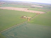 Beacon Hill farm on Mareham Lane
 Mareham Lane near Scredington
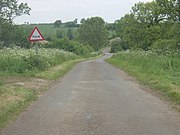 Ford just north of Graby
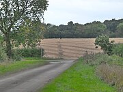 Roman Alignment through cornfield