List of bays of the Firth of Clyde

Last updated

Map of Firth of Clyde Firthofclydemap.png
Map of Firth of Clyde

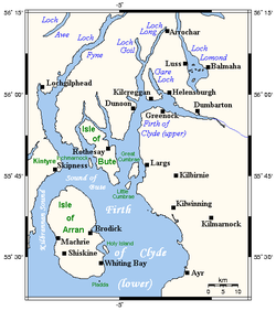
This List of bays of the Firth of Clyde summarises the bays that are located in the islands of the Firth of Clyde in Scotland

Contents

Arran

NameCountyNearest TownCoordinatesImageNotes
Brodick Bay North Ayrshire Brodick 55°34′16″N5°06′23″W / 55.571°N 5.1063°W / 55.571; -5.1063 (Brodick Bay)
Brodick Bay - geograph.org.uk - 920049.jpg
[1]
Catacol Bay North Ayrshire Lochranza 55°41′23″N5°19′57″W / 55.6896°N 5.3325°W / 55.6896; -5.3325 (Catacol Bay)
View across Catacol Bay towards Catacol - geograph.org.uk - 3775841.jpg
[2]
Drumadoon Bay North Ayrshire Blackwaterfoot 55°29′48″N5°20′29″W / 55.4968°N 5.3413°W / 55.4968; -5.3413 (Drumadoon Bay) [3]
Kerr's Port North Ayrshire Lamlash 55°32′53″N5°05′27″W / 55.5481°N 5.0907°W / 55.5481; -5.0907 (Kerr's Port)
Path to Clauchlands Point - geograph.org.uk - 2411546.jpg
Lamlash Bay North Ayrshire Lamlash 55°31′51″N5°06′13″W / 55.5309°N 5.1036°W / 55.5309; -5.1036 (Lamlash Bay)
Machrie Bay North Ayrshire Machrie 55°33′18″N5°21′11″W / 55.555°N 5.3530°W / 55.555; -5.3530 (Machrie Bay)
Shore between Machrie and Auchecar - geograph.org.uk - 5884975.jpg
[3]
Port a' Ghille Ghlais North Ayrshire Whiting Bay 55°26′21″N5°09′13″W / 55.4391°N 5.1535°W / 55.4391; -5.1535 (Port a' Ghille Ghlais)
View from Port a' Ghille Ghlais - geograph.org.uk - 3249760.jpg
Port Dearg North Ayrshire Whiting Bay 55°26′22″N5°06′55″W / 55.4394°N 5.1154°W / 55.4394; -5.1154 (Port Dearg)
Kildonan Beach - geograph.org.uk - 3245496.jpg
Port na Feannaiche North Ayrshire Lagg 55°27′23″N5°17′32″W / 55.4564°N 5.2921°W / 55.4564; -5.2921 (Port na Feannaiche)
Port na Feannaiche seen from The Arran Coastal Way - geograph.org.uk - 7576219.jpg
Port Mòr North Ayrshire Blackwaterfoot 55°26′45″N5°15′50″W / 55.4457°N 5.264°W / 55.4457; -5.264 (Port Mòr)
A dyke near Port Mor, Arran - geograph.org.uk - 7592558.jpg
Port Mòr North Ayrshire Whiting Bay 55°28′54″N5°05′23″W / 55.4818°N 5.0896°W / 55.4818; -5.0896 (Port Mòr)
Porta Buidhe North Ayrshire Lagg, Arran 55°26′27″N5°07′26″W / 55.4408°N 5.1238°W / 55.4408; -5.1238 (Porta Buidhe)
Shoreline, Kildonan, Arran - geograph.org.uk - 7576989.jpg
Porta Leacach North Ayrshire Kildonan 55°26′57″N5°05′34″W / 55.4493°N 5.0927°W / 55.4493; -5.0927 (Porta Leacach)
Sannox Bay North Ayrshire Sannox 55°39′38″N5°08′56″W / 55.6605°N 5.1490°W / 55.6605; -5.1490 (Sannox Bay)
Sannox Bay - geograph.org.uk - 2358965.jpg
Whiting Bay North Ayrshire Whiting Bay 55°29′03″N5°04′52″W / 55.4843°N 5.0810°W / 55.4843; -5.0810 (Whiting Bay)
Whiting Bay Beach (geograph 3593622).jpg
[4]

Bute

NameCountyNearest TownCoordinatesImageNotes
Ascog Bay Argyll and Bute Rothesay 55°49′37″N5°01′24″W / 55.8269°N 5.0232°W / 55.8269; -5.0232 (Ascog Bay)
Ascog Bay - geograph.org.uk - 5923591.jpg
[5]
Balnakailly Bay Argyll and Bute Rothesay 55°55′21″N5°10′09″W / 55.9225°N 5.1692°W / 55.9225; -5.1692 (Balnakailly Bay)
Woods reach the shore at Balnakailly Bay - geograph.org.uk - 4360074.jpg
[6]
Dunagoil Bay Argyll and Bute Rothesay 55°44′12″N5°03′12″W / 55.7368°N 5.0532°W / 55.7368; -5.0532 (Dunagoil Bay)
Dunagoil Bay - geograph.org.uk - 2415276.jpg
Ettrick Bay Argyll and Bute Rothesay 55°50′39″N5°08′30″W / 55.8443°N 5.1417°W / 55.8443; -5.1417 (Ettrick Bay)
Ettrick Bay, Isle of Bute - geograph.org.uk - 5894863.jpg
[7]
Gallachan Bay Argyll and Bute Rothesay 55°45′57″N5°04′42″W / 55.7659°N 5.0784°W / 55.7659; -5.0784 (Gallachan Bay)
Glencallum Bay Argyll and Bute Rothesay 55°43′47″N5°00′25″W / 55.7296°N 5.0069°W / 55.7296; -5.0069 (Glencallum Bay)
Kames Bay Argyll and Bute Rothesay 55°52′00″N5°04′53″W / 55.8666°N 5.0814°W / 55.8666; -5.0814 (Kames Bay)
Kerrycroy Bay Argyll and Bute Rothesay 55°48′35″N5°01′16″W / 55.8096°N 5.0212°W / 55.8096; -5.0212 (Kerrycroy Bay)
Kerrylamont Bay Argyll and Bute Rothesay 55°46′39″N5°00′15″W / 55.7776°N 5.0042°W / 55.7776; -5.0042 (Kerrylamont Bay)
Kilchattan Bay Argyll and Bute Rothesay 55°45′22″N5°01′23″W / 55.7560°N 5.0230°W / 55.7560; -5.0230 (Kilchattan Bay)
Kilchattan Bay - Isle of Bute - geograph.org.uk - 6167637.jpg
Lubas Bay Argyll and Bute Rothesay 55°44′36″N5°03′28″W / 55.7433°N 5.0579°W / 55.7433; -5.0579 (Lubas Bay)
Lubas Bay - Isle of Bute - geograph.org.uk - 5588467.jpg
Port na h-Aille Argyll and Bute Rothesay 55°46′40″N5°07′21″W / 55.7779°N 5.1225°W / 55.7779; -5.1225 (Port na h-Aille)
Rothesay Bay Argyll and Bute Rothesay 55°50′42″N5°01′40″W / 55.8451°N 5.0278°W / 55.8451; -5.0278 (Rothesay Bay)
Bogany Point, Isle of Bute - geograph.org.uk - 4052783.jpg
Scalpsie Bay Argyll and Bute Rothesay 55°46′32″N5°06′11″W / 55.7755°N 5.103°W / 55.7755; -5.103 (Scalpsie Bay)
Across Scalpsie Bay - geograph.org.uk - 7182363.jpg
[8]
Sallan Port Argyll and Bute Rothesay 55°47′41″N5°07′38″W / 55.7946°N 5.1272°W / 55.7946; -5.1272 (Sallan Port)
St Ninian's Bay Argyll and Bute Rothesay 55°48′18″N5°07′48″W / 55.8049°N 5.1299°W / 55.8049; -5.1299 (St Ninian's Bayt)
St Ninian's Chapel - Isle of Bute - geograph.org.uk - 5830382.jpg
Stravanan Bay Argyll and Bute Rothesay 55°45′32″N5°04′02″W / 55.7588°N 5.0671°W / 55.7588; -5.0671 (Stravanan Bay)
Stravannan Bay Isle of Bute - geograph.org.uk - 3542675.jpg

Davaar

The small island of Davaar has no bays.

Great Cumbrae

NameCountyNearest TownCoordinatesImageNotes
Ballochmartin Bay North Ayrshire Millport 55°46′22″N4°53′54″W / 55.7728°N 4.8983°W / 55.7728; -4.8983 (Ballochmartin Bay)
Stinking Goat - geograph.org.uk - 4891508.jpg
[9]
Bell Bay North Ayrshire Millport 55°46′39″N4°55′57″W / 55.7774°N 4.9324°W / 55.7774; -4.9324 (Bell Bay)
Great Cumbrae, Firth of Clyde - geograph.org.uk - 2536452.jpg
[10]
Deadman's Bay North Ayrshire Millport 55°45′47″N4°56′41″W / 55.763°N 4.9447°W / 55.763; -4.9447 (Deadman's Bay)
Deadman's Bay, Great Cumbrae Island - geograph.org.uk - 668185.jpg
Fintray Bay North Ayrshire Millport 55°46′08″N4°56′18″W / 55.769°N 4.9382°W / 55.769; -4.9382 (Fintray Bay)
Fintry Bay, Great Cumbrae Island - geograph.org.uk - 668734.jpg
[11]
Holm Bay North Ayrshire Millport 55°47′22″N4°53′52″W / 55.7895°N 4.8979°W / 55.7895; -4.8979 (Holm Bay)
The view from Great Cumbrae Ferry Terminal - geograph.org.uk - 4893302.jpg
Kames Bay North Ayrshire Millport 55°45′08″N4°55′02″W / 55.7522°N 4.9171°W / 55.7522; -4.9171 (Kames Bay)
Kames Bay View - geograph.org.uk - 3398471.jpg
[12]
Lady's Bay North Ayrshire Millport 55°47′25″N4°53′52″W / 55.7904°N 4.8979°W / 55.7904; -4.8979 (Lady's Bay)
Knox's Port North Ayrshire Millport 55°45′00″N4°55′57″W / 55.7501°N 4.9325°W / 55.7501; -4.9325 (Knox's Port)
Millport Bay North Ayrshire Millport 55°44′54″N4°55′34″W / 55.7484°N 4.9261°W / 55.7484; -4.9261 (Millport Bay) [13]
Newtown Bay North Ayrshire Millport 55°45′06″N4°55′40″W / 55.7518°N 4.9278°W / 55.7518; -4.9278 (Newtown Bay)
Skate Bay North Ayrshire Millport 55°47′07″N4°55′42″W / 55.7853°N 4.9282°W / 55.7853; -4.9282 (Skate Bay) [14]
Stinking Bay North Ayrshire Millport 55°47′29″N4°55′05″W / 55.7913°N 4.9181°W / 55.7913; -4.9181 (Stinking Bay) [15]
White Bay North Ayrshire Millport 55°47′31″N4°54′32″W / 55.7919°N 4.9088°W / 55.7919; -4.9088 (White Bay) [16]
Wine Bay North Ayrshire Millport 55°47′28″N4°55′03″W / 55.7910°N 4.9174°W / 55.7910; -4.9174 (Wine Bay) [17]

Holy Island

The small island of Holy Island has no bays.

Inchmarnock

The small island of Inchmarnock has no bays.

Little Cumbrae

NameCountyNearest TownCoordinatesImageNotes
Long Bay North Ayrshire West Kilbride 55°43′52″N4°57′02″W / 55.7310°N 4.9506°W / 55.7310; -4.9506 (Long Bay)
Long Bay, Little Cumbrae - geograph.org.uk - 78114.jpg
Steadholm Bay North Ayrshire West Kilbride 55°42′59″N4°57′54″W / 55.7163°N 4.9651°W / 55.7163; -4.9651 (Steadholm Bay)
Steadholm Bay from Waterloo point, Little Cumbrae. - geograph.org.uk - 78100.jpg
Waterloo Bay North Ayrshire West Kilbride 55°42′45″N4°57′34″W / 55.7126°N 4.9594°W / 55.7126; -4.9594 (Waterloo Bay)
Gull Point, Little Cumbrae - geograph.org.uk - 78097.jpg

Sanda

The small island of Sanda has no bays.

See also

References

  1. Adam and Charles Black (Firm) (1881). Black's Tourist's Guide to Scotland. p. 111. Retrieved 7 May 2021.
  2. United States. Hydrographic Office (1925). British Islands Pilot. U.S. Government Printing Office. p. 99.
  3. 1 2 United States. Hydrographic Office (1925). British Islands Pilot. U.S. Government Printing Office. p. 98.
  4. "Whiting Bay". Visiting Scotland. Visit Scotland. Retrieved 30 May 2021.
  5. Groome, Francis Hindes (1882). Ordnance Gazetteer of Scotland: A Survey of Scottish Topography, Statistical, Biographical and Historical. Edinburgh: T. C. Jack. p. 79.
  6. "Balnakailly Bay". Gazetteer for Scotland. School of GeoSciences, University of Edinburgh and The Royal Scottish Geographical Society. Retrieved 25 April 2023.
  7. "Ettrick Bay". Gazetteer for Scotland. School of GeoSciences, University of Edinburgh and The Royal Scottish Geographical Society. Retrieved 20 April 2017.
  8. Murphy, Alan (10 April 2014). Scotland Highlands & Islands Footprint Handbook. Footprint Travel Guides. p. 72. ISBN   978-1-909268-62-3.
  9. United States. Naval Oceanographic Office. Sailing Directions for the West Coast of Scotland, Mull of Galloway to Cape Wrath, Including Hebrides. p. 48.
  10. "Bell Bay". Gazetteer for Scotland. School of GeoSciences, University of Edinburgh and The Royal Scottish Geographical Society. Retrieved 25 April 2023.
  11. "Fintray Bay". Gazetteer for Scotland. School of GeoSciences, University of Edinburgh and The Royal Scottish Geographical Society. Retrieved 25 April 2023.
  12. Great Britain. Hydrographic Department (1886). West Coast of Scotland Pilot. J. D. Potter. p. 287.
  13. Clyde Cruising Club (24 April 2020). Firth of Clyde: Including Solway Firth and North Channel. Imray, Laurie, Norie and Wilson Ltd. p. 35. ISBN   978-1-78679-165-8.
  14. "Skate Bay". Gazetteer for Scotland. School of GeoSciences, University of Edinburgh and The Royal Scottish Geographical Society. Retrieved 25 April 2023.
  15. Transactions of the Glasgow Archaeological Society. Society. 1883. p. 175.
  16. "White Bay". Gazetteer for Scotland. School of GeoSciences, University of Edinburgh and The Royal Scottish Geographical Society. Retrieved 25 April 2023.
  17. "Wine Bay". Gazetteer for Scotland. School of GeoSciences, University of Edinburgh and The Royal Scottish Geographical Society. Retrieved 25 April 2023.