Related Research Articles
The transport sector comprises the physical infrastructure, docks and vehicle, terminals, fleets, ancillary equipment and service delivery of all the various modes of transport operating in Guyana. The transport services, transport agencies providing these services, the organizations and people who plan, build, maintain, and operate the system, and the policies that mold its development.

Suriname, officially known as the Republic of Suriname, is a country on the northeastern Atlantic coast of South America. It is bordered by the Atlantic Ocean to the north, French Guiana to the east, Guyana to the west and Brazil to the south. At just under 165,000 square kilometers, it is the smallest sovereign state in South America. Suriname has a population of approximately 575,990, most of whom live on the country's north coast, in and around the capital and largest city, Paramaribo.
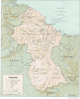
The Geography of Guyana comprises the physical characteristics of the country in Northern South America and part of Caribbean South America, bordering the North Atlantic Ocean, between Suriname and Venezuela, with a land area of approximately 214,969 square kilometres. The country is situated between 1 and 9 north latitude and between 56 and 62 west longitude. With a 459 km (285 mi)-long Atlantic coastline on the northeast, Guyana is bounded by Venezuela on the west, Brazil on the west and south, and Suriname on the east. The land comprises three main geographical zones: the coastal plain, the white sand belt and the interior highlands.

Paramaribo is the capital and largest city of Suriname, located on the banks of the Suriname River in the Paramaribo District. Paramaribo has a population of roughly 241,000 people, almost half of Suriname's population. The historic inner city of Paramaribo has been a UNESCO World Heritage Site since 2002.

Dutch colonisation of the Guianas—the coastal region between the Orinoco and Amazon rivers in South America—began in the late 16th century. The Dutch originally claimed all of Guiana but—following attempts to sell it first to Bavaria and then to Hanau and the loss of sections to Portugal, Britain, and France—the section actually settled and controlled by the Netherlands became known as Dutch Guiana.

The Oyapock or Oiapoque is a 403-kilometre (250 mi) long river in South America that forms most of the border between the French overseas department of French Guiana and the Brazilian state of Amapá.
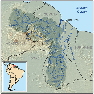
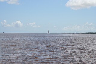
The Courantyne/Corentyne/Corantijn River is a river in northern South America in Suriname. It is the longest river in the country and creates the border between Suriname and the East Berbice-Corentyne region of Guyana.
The Rupununi is a region in the south-west of Guyana, bordering the Brazilian Amazon. The Rupununi river, also known by the local indigenous peoples as Raponani, flows through the Rupununi region. The name Rupununi originates from the word rapon in the Makushi language, in which it means the black-bellied whistling duck found along the river.
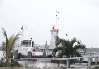
Moleson Creek is a community on the Corentyne River in the East Berbice-Corentyne region of Guyana, and home to the Guyana-Suriname ferry stelling. It is north of Orealla Mission, 10 km (6.2 mi) south of Corriverton, and approximately 90 km (56 mi) from New Amsterdam.

Brazil–Guyana relations have traditionally been close. Brazil has provided military assistance to Guyana in the form of warfare training and logistics. Bilateral relations between the countries have recently increased, as a result of Brazil's new South-South foreign policy aimed to strengthen South American integration.
The Initiative for the Integration of the Regional Infrastructure of South America (IIRSA) is a development plan to link South America's economies through new transportation, energy, and telecommunications projects.

Guyana, officially the Co‑operative Republic of Guyana, is a country on the northern mainland of South America and the capital city is Georgetown. It is part of the mainland Caribbean region maintaining its strong cultural, historical, and political ties with other Caribbean countries and the Caribbean Community (CARICOM). Guyana is bordered by the Atlantic Ocean to the north, Brazil to the south and southwest, Venezuela to the west, and Suriname to the east. With 215,000 square kilometres (83,000 sq mi), Guyana is the third-smallest sovereign state by area in mainland South America after Uruguay and Suriname; it is also the second-least populous sovereign state in South America after Suriname.

French Guiana is an overseas department/region and single territorial collectivity of France on the northern Atlantic coast of South America in the Guianas. It borders Brazil to the east and south and Suriname to the west. French Guiana is the only territory of the mainland Americas to have full integration in a European country.
Westelijke Polders is a resort in Suriname, located in the Nickerie District. Its population at the 2012 census was 8,616. Its Dutch place name reflects Suriname's colonial past. Its western boundary is the Courantyne River, between Suriname and Guyana.
The (northern) East-West Link is a road in Suriname between Albina in the eastern part of the country to Nieuw Nickerie in the western part, via the capital city of Paramaribo. The southern East-West Link connects Paramaribo with Apoera via Bitagron. Construction of the road link started in the 1960s.

South Drain, also Zuiddrain, is a town in western Suriname. Since the pavement of 32 kilometres (20 mi) road section to Nieuw Nickerie, it is the final destination of the northern East-West Link. The European Union funded the reconstruction, which started in 2007, with 13.2 million euro. The section was opened on 30 April 2010. There is a jeep trail between South Drain and Apoera, connecting the Northern East-West Link with the Southern East-West Link. Contrary to earlier plans, the pavement of this road is not imminent.

The Oyapock River Bridge spans the Oyapock River, linking the cities of Oiapoque in Amapá, Brazil and Saint-Georges-de-l'Oyapock in French Guiana, France. The bridge is cable-stayed, with two towers rising to a height of 83 metres (272 ft) and a length of 378 metres (1,240 ft). There are two lanes for vehicles with a total width of 9 metres (30 ft) and a pedestrian sidewalk with a width of 2.50 metres. The vertical clearance under the bridge is 15 metres (49 ft).

The borders of Suriname consist of land borders with three countries: Guyana, Brazil, and France. The borders with Guyana and France are in dispute, but the border with Brazil has been uncontroversial since 1906.
The Berbice Bridge is a pontoon bridge over the Berbice River near New Amsterdam in Guyana. The bridge is tolled and was opened on 23 December 2008.
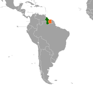
Guyana – Suriname relations refer to the bilateral relations between Guyana and Suriname. Suriname has an embassy in Georgetown. Guyana has an embassy in Paramaribo. The Courantyne River makes up most of the border between the two countries.
References
- ↑ "Country Infrastructure Briefs: Caribbean Region" (PDF). Inter-American Development Bank . April 2019. Retrieved 2021-02-17.
- ↑ "Guyana, Suriname reaffirm commitment to co-operation". CARICOM Today. 2020-10-19. Retrieved 2021-02-17.