A per capita GDP of $3,200 ranks Solomon Islands as a lesser developed nation. Over 75% of its labour force is engaged in subsistence farming and fishing.

Melanesia is a subregion of Oceania extending from New Guinea island in the southwestern Pacific Ocean to the Arafura Sea, and eastward to Fiji.
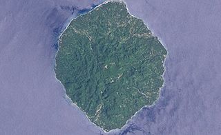
Savo Island is an island in Solomon Islands in the southwest South Pacific ocean. Administratively, Savo Island is a part of the Central Province of the Solomon Islands. It is about 35 km from the capital Honiara. The principal village is Alialia, in the north of the island. The indigenous language of Savo is the Savosavo language, an East Papuan language. The waters surrounding the island were the site of five of the seven major naval battles during the Battle of Guadalcanal in the Pacific War. As a result of these battles southeast of the island are many shipwrecks, the bay is known as Ironbottom Sound. The wrecks near the coast are very popular with wreck divers.

The Solomon Islands national football team is the national football team of Solomon Islands and is administered by the Solomon Islands Football Federation. The Solomon Islands national football team was founded in 1978. They were officially recognised by FIFA a decade later, in 1988.
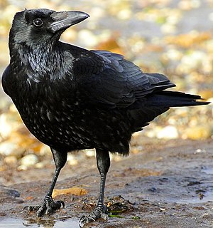
A crow is a bird of the genus Corvus, or more broadly a synonym for all of Corvus. The term "crow" is used as part of the common name of many species. Species with the word "crow" in their common name include:

The Solomon Sea is a sea located within the Pacific Ocean. It lies between Papua New Guinea and the Solomon Islands. Many major battles were fought there during World War II.

The culture of the Solomon Islands reflects the extent of the differentiation and diversity among the groups living within the Solomon Islands archipelago, which lies within Melanesia in the Pacific Ocean, with the peoples distinguished by island, language, topography, and geography. The cultural area includes the nation state of Solomon Islands and the Bougainville Island, which is a part of Papua New Guinea.

British Solomon Islands Protectorate was first declared over the southern Solomons in 1893, when Captain Gibson R.N., of HMS Curacoa, declared the southern islands a British Protectorate. Other islands were subsequently declared to form part of the Protectorate over a period ending in 1900.

The Northern Solomons were the more northerly group of islands in the Solomon Islands archipelago over which Germany declared a protectorate in 1885. Initially the German Solomon Islands Protectorate included Choiseul, Santa Isabel, the Shortlands and Ontong Java Islands, but in 1900 these islands were transferred to the British Solomon Islands Protectorate. The largest of the Solomon Islands, Bougainville, continued under German administration until World War I when it fell to Australia, and after the war, it formally passed to Australian jurisdiction under a League of Nations mandate.

The Prime Minister of Solomon Islands is Solomon Islands' head of government, consequent on being the leader of the party or coalition with majority support in the National Parliament. Since 15 November 2017, the Prime Minister has been Rick Houenipwela.
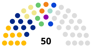
The National Parliament of Solomon Islands has 50 members, elected for a four-year term in 50 single-seat constituencies.

The monarchy of Solomon Islands is a system of government in which a constitutional monarch is the head of state of Solomon Islands. The present monarch is Queen Elizabeth II, who is also the head of state of fifteen other Commonwealth realms.

The Solomon Islands national rugby union team represent Solomon Islands in the sport of rugby union.

The Solomon Islands first participated at the Olympic Games in 1984, and has sent athletes to compete in every Summer Olympic Games since then. The nation has never participated in the Winter Olympic Games.

Solomon Islands – United States relations are bilateral relations between Solomon Islands and the United States.
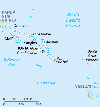
The Solomon Islands are an archipelago in the western South Pacific Ocean, located northeast of Australia. They are in the Melanesia subregion and bioregion of Oceania. The archipelago forms much of the territory of Solomon Islands, while the northwestern islands are within the Autonomous Region of Bougainville, in eastern Papua New Guinea. It forms the eastern boundary of the Solomon Sea.
The Solomons Temple Islands are an uninhabited Canadian arctic islands group located within the midsection of James Bay in Nunavut, Canada. They are situated north of Charlton Island, and southwest of Paint Hills Islands, Pointe au Huard and Andrew Moar Bay,

There are between sixty and seventy languages spoken in the Solomon Islands archipelago as opposed to the nation state of Solomon Islands, which covers a smaller area. The lingua franca is Pijin, and the official language is English.
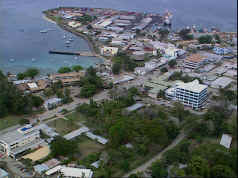
Honiara is the capital city of Solomon Islands, situated on the northwestern coast of Guadalcanal. As of 2017, it had a population of 84,520 people. The city is served by Honiara International Airport and the seaport of Point Cruz, and lies along the Kukum Highway.