

Allentown, Pennsylvania is nationally-known for its park system.
Allentown, Pennsylvania is nationally-known for its park system.
Much of the initial planning and funding of Allentown's park system began in the early 20th century, supported by Harry Clay Trexler, a local industrialist who was inspired by the City Beautiful movement. Trexler brought in B. A. Haldeman, a nationally known city park consultant, to Allentown, and Haldeman provided the plans for the development of the growing city. J. Franklin Meehan of Philadelphia was the landscape architect who laid out many of the city's first public parks. [1]
In 1906, Trexler hired Meehan to lay out a park on the land, which opened in 1909. West Park features a bandshell, designed by Philadelphia architect Horace Trumbauer, which has long been home to the Allentown Band and other community bands. [2] Soon after, it became apparent that a need existed for recreational facilities for children and young people. Meetings of the Allentown City Council were held about this and several proposals were presented and discussed.
Allen Park, located in the vicinity of Trout Hall, was the first city park in Allentown, although it did not become city property until 1908. [1] A 6.59-acre (26,700 m2) park in what was a community trash pit and sandlot baseball field became Allen Park, the city's first public park [2] established in an upscale area of the city.
In 1912, the city's first public playground was established at Fountain Park. [1] During the summer vacation months, all Allentown School District school grounds are open as neighborhood playgrounds.
Trexler also facilitated the development of Cedar Creek Park, the Allentown Municipal Golf Course and the Trout Nursery in Lehigh Parkway.
Following Trexler's death in 1933, Trexler's summer estate, a 142-acre tract was willed to the City of Allentown and was renamed Trexler Memorial Park. The Harry C. Trexler Trust continues to provide private funding for the maintenance and development of Allentown's public park system. [3]
The following is a list of city parks and recreation facilities located in Allentown: [4]
|

Lehigh County is a county in the Commonwealth of Pennsylvania. As of the 2020 census, the county's population was 374,557. Its county seat is Allentown, the state's third-largest city after Philadelphia and Pittsburgh.

Allentown is a city in the Commonwealth of Pennsylvania and the county seat of Lehigh County, in the United States. It is the third-most-populous city in Pennsylvania with a population of 125,845 as of the 2020 census and the largest city in the Lehigh Valley metropolitan area, which had a population of 861,899 and was the 68th-most populous metropolitan area in the nation as of 2020.

North Catasauqua is a borough in Northampton County, Pennsylvania. The borough was founded in 1907. The population of North Catasauqua was 2,971 at the 2020 census. The borough is part of the Lehigh Valley metropolitan area, which had a population of 861,899 and was the 68th-most populous metropolitan area in the U.S. as of the 2020 census.

Pottsville is the county seat of Schuylkill County, Pennsylvania, United States. The population was 13,346 at the 2020 census, and is the principal city of the Pottsville, PA Micropolitan Statistical Area. The city lies along the west bank of the Schuylkill River, 52 miles (84 km) south of Wilkes-Barre. It is located in Pennsylvania's Coal Region.

The Lehigh Valley is a geographic and metropolitan region formed by the Lehigh River in Lehigh and Northampton Counties in eastern Pennsylvania. It is a component valley of the Great Appalachian Valley bounded to its north by Blue Mountain, to its south by South Mountain, to its west by Lebanon Valley, and to its east by the Delaware River and Warren County, New Jersey. The Valley is about 40 miles (64 km) long and 20 miles (32 km) wide. The Lehigh Valley's largest city is Allentown, the third-largest city in Pennsylvania and the county seat of Lehigh County, with a population of 125,845 residents as of the 2020 census.

Hubbard Street is a street in Chicago, Illinois named for early settler Gurdon Saltonstall Hubbard. Hubbard Street has three distinct sections. The first, east of the Chicago River, runs from Kingsbury Street to Michigan Avenue. The second, longer section runs from Des Plaines Street west to Campbell Avenue The third and shortest section is a three-block stretch from Kilpatrick Avenue to Lavergne Avenue where it ends at the Hubbard Playlot Park. Notable buildings on this street include Courthouse Place at 54 W. Hubbard.

Henry Clay Trexler was an American industrialist, businessman, and major philanthropist who contributed to the economic development of Allentown, Pennsylvania and the surrounding Lehigh Valley in the late 19th and early 20th centuries. He bequeathed the majority of his estate to create the Harry C. Trexler Trust, which has since dispensed more than $150 million in Lehigh County, Pennsylvania.

Lake Balboa is a neighborhood in the San Fernando Valley region of Los Angeles, California. The area was previously part of Van Nuys.

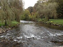
Lehigh Parkway is a large, 629-acre public park along the Little Lehigh Creek in Allentown, Pennsylvania in the Lehigh Valley region of eastern Pennsylvania. It is the most prominent park in the city and follows the Little Lehigh Creek southward for three miles from center city Allentown to Cedar Crest Boulevard in neighboring Emmaus.

Little Lehigh Creek is approximately 24.0 miles (38.6 km) long and is located in the Lehigh Valley region of eastern Pennsylvania. It is sometimes referred to as the Little Lehigh River. It is the largest tributary of the Lehigh River.
Cedar Crest Boulevard, colloquially known as Cedar Crest and The Boulevard, is a major north-south highway in Lehigh County, Pennsylvania in the Lehigh Valley region of eastern Pennsylvania. South of Interstate 78 (I-78), the road is part of Pennsylvania Route 29. North of it, the road becomes State Route 1019.
The Near East Side is a neighborhood located near downtown Columbus, Ohio, made up of several neighborhoods: Mount Vernon, King-Lincoln Bronzeville, Eastgate, Franklin Park, Nelson Park, Olde Towne East, and Woodland Park.
Lehigh Street is a major road that connects Emmaus, Pennsylvania in the west to Allentown, Pennsylvania in the east in the Lehigh Valley region of eastern Pennsylvania. The road is one of six roads that enter and depart Allentown, the third-largest city in Pennsylvania.
The Allentown School District is a large, urban public school district located in Allentown, Pennsylvania in the Lehigh Valley region of eastern Pennsylvania. The district is the fourth-largest school district in Pennsylvania as of the 2016-17 academic year.

The Liberty Bell Museum, also the Liberty Bell Shrine Museum was a non-profit organization and museum located in Zion's United Church of Christ, formerly Zion's Reformed Church, in Allentown, Pennsylvania in the Lehigh Valley region of eastern Pennsylvania. The museum was located in the basement of the church, where the Liberty Bell, an iconic and globally-recognized symbol of America's independence, was hidden from the British Army by Allentown-area American patriots during the American Revolutionary War from September 1777 to June 1778.
The culture of Allentown, Pennsylvania dates back to the early 18th century settlement of the city and the surrounding Lehigh Valley, which was then part of the Province of Pennsylvania, one of the original Thirteen Colonies, by German immigrants almost exclusively affiliated the Lutheran, Moravian, and Reformed faiths, three of the most prominent Protestant denominations.

Center City Allentown is the downtown and central business district of Allentown, Pennsylvania, the third largest city in the U.S. state of Pennsylvania. It has a dense population and is currently undergoing an urban revitalization process.

The Trexler Nature Preserve is an 1,108-acre county park (448 ha) owned and maintained by Lehigh County in the Lehigh Valley region of Pennsylvania. The preserve is situated in Lowhill Township and North Whitehall Township and the land that comprises the preserve was originally purchased between 1901 and 1911 by local industrialist General Harry Clay Trexler.

The Lehigh Line is a railroad line in Central New Jersey, Northeastern Pennsylvania, and the Lehigh Valley region of eastern Pennsylvania. It is owned and operated by the Norfolk Southern Railway. The line runs west from the vicinity of the Port of New York and New Jersey in Manville, New Jersey via Conrail's Lehigh Line to the southern end of Wyoming Valley's Coal Region in Lehigh Township, Pennsylvania.