The bridges are an important tourist attraction, both economically and culturally. This is due to both their historical significance and, being in the heart of Pennsylvania Dutch country, the frequent, iconic Amishhorse and buggies bridge crossings. They are often visited in the form of covered bridge driving tours.[4]
History
In the early to late 1800s there were approximately 1,500 covered bridges in the state of Pennsylvania. That number has decreased to just over 200 bridges, with more located in Lancaster County than any other county in the state.[5] The remaining covered bridges in the county are a remnant of a time when most bridges in the United States were made from wood, since wood was relatively inexpensive and easy to acquire. Bridge making, however, was anything but easy and required significant cost, effort, and time. The cost of the building the bridges was covered by government funds or by private individuals building bridges across their land. Since the bridges were built from wood, they were covered to provide protection from the weather, dramatically extending the life of the bridges. Nevertheless, as floods and fires destroyed more bridges, they were eventually replaced or bypassed with more durable and longer-lasting reinforced concrete and steel beam bridges.[6] Most of the existing bridges are owned by the county government which is responsible for periodic upkeep and maintenance.[7]
Modern status
Throughout the years, many of the existing covered bridges have been destroyed, but were later reconstructed. For example, in 1972 a number of the county's covered bridges were either destroyed or badly damaged as a result of flooding caused by Hurricane Agnes. Notably, the Zook's Mill Covered Bridge managed to survive despite being filled with a few feet of water. The Willow Hill Covered Bridge, a relatively new bridge built in 1962, is a reconstructed bridge using materials recovered from the old Miller's Farm and Good's Fording covered bridges.
Design
The covered bridges in Lancaster County are all built of similar construction and appearance. Some of this is because many of the existing bridges were built by the same man, Elias McMellen, who built 12 of the existing bridges. The most common construction method used was that of the Burr arch truss. It is found in its single and double span forms in almost all of the covered bridges in the county, except for the Landis Mill Covered Bridge, a multiple kingpost design. The Pine Grove Covered Bridge and Herr's Mill Covered Bridge (now gone) are the county's only double span covered bridges. While most of the bridges are situated in remote locations where there is limited traffic, a number of the bridges, such as Jackson's Sawmill Covered Bridge, were later reinforced with steel beams underneath the bridge floor and steel hanger rods on the sides to support heavier traffic or give the bridge additional support.
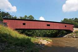
Historically, the Lancaster County covered bridges were painted with red sides and all-white portals.[6] Today most of the bridges retain this pattern, however, some of the portals are painted red with white trim (such as on the Zook's Mill Covered Bridge) or all-red (such as on the Pool Forge Covered Bridge). A number of these bridges also have the side panels painted red on the inside of the bridge while leaving the trusses unpainted. The Keller's Mill Covered Bridge is painted all-white, the only one of its kind in the county. Three of the bridges, Buck Hill Covered Bridge, Schenck's Mill Covered Bridge, and Shearer's Covered Bridge, have horizontal side boards. The rest of the bridges have vertical side boards.
The traditional colors of a Lancaster County covered bridge: red sides and white portals
An example of the Burr arch truss design used in most of Lancaster County's covered bridges
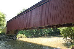
The underside of the Jackson's Sawmill Covered Bridge showing the reinforced steel bracing
A Burr arch truss reinforced with steel hanger rods
Pennsylvania Railroad Bridge‡ - Created in the 1820s, burnt during the American Civil War in July 1863. It was the longest covered bridge in the world (over a mile and a quarter in length).
↑McCain, Roger A. "Covered Bridges by County and State". A Guide to Old Covered Bridges of Southeastern Pennsylvania and nearby areas. Archived from the original on August 16, 2006. Retrieved August 3, 2006.
This page is based on this Wikipedia article Text is available under the CC BY-SA 4.0 license; additional terms may apply. Images, videos and audio are available under their respective licenses.