Related Research Articles

An earthquake – also called a quake, tremor, or temblor – is the shaking of the Earth's surface resulting from a sudden release of energy in the lithosphere that creates seismic waves. Earthquakes can range in intensity, from those so weak they cannot be felt, to those violent enough to propel objects and people into the air, damage critical infrastructure, and wreak destruction across entire cities. The seismic activity of an area is the frequency, type, and size of earthquakes experienced over a particular time. The seismicity at a particular location in the Earth is the average rate of seismic energy release per unit volume.
The Modified Mercalli intensity scale measures the effects of an earthquake at a given location. This is in contrast with the seismic magnitude usually reported for an earthquake.

Seismology is the scientific study of earthquakes and the generation and propagation of elastic waves through the Earth or other planetary bodies. It also includes studies of earthquake environmental effects such as tsunamis as well as diverse seismic sources such as volcanic, tectonic, glacial, fluvial, oceanic microseism, atmospheric, and artificial processes such as explosions and human activities. A related field that uses geology to infer information regarding past earthquakes is paleoseismology. A recording of Earth motion as a function of time, created by a seismograph is called a seismogram. A seismologist is a scientist works in basic or applied seismology.

The epicenter, epicentre, or epicentrum in seismology is the point on the Earth's surface directly above a hypocenter or focus, the point where an earthquake or an underground explosion originates.
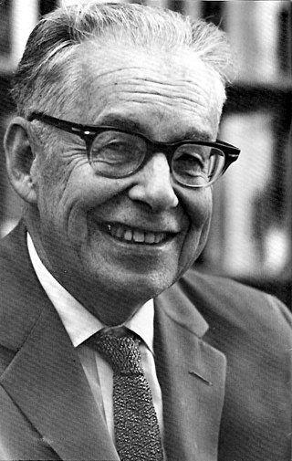
Charles Francis Richter was an American seismologist and physicist. He is the namesake and one of the creators of the Richter magnitude scale, which, until the development of the moment magnitude scale in 1979, was widely used to quantify the size of earthquakes. Inspired by Kiyoo Wadati's 1928 paper on shallow and deep earthquakes, Richter first used the scale in 1935 after developing it in collaboration with Beno Gutenberg; both worked at the California Institute of Technology.
The moment magnitude scale is a measure of an earthquake's magnitude based on its seismic moment. Mw was defined in a 1979 paper by Thomas C. Hanks and Hiroo Kanamori. Similar to the local magnitude/Richter scale (ML ) defined by Charles Francis Richter in 1935, it uses a logarithmic scale; small earthquakes have approximately the same magnitudes on both scales. Despite the difference, news media often use the term "Richter scale" when referring to the moment magnitude scale.
Seismic magnitude scales are used to describe the overall strength or "size" of an earthquake. These are distinguished from seismic intensity scales that categorize the intensity or severity of ground shaking (quaking) caused by an earthquake at a given location. Magnitudes are usually determined from measurements of an earthquake's seismic waves as recorded on a seismogram. Magnitude scales vary based on what aspect of the seismic waves are measured and how they are measured. Different magnitude scales are necessary because of differences in earthquakes, the information available, and the purposes for which the magnitudes are used.
Susan Elizabeth Hough is a seismologist at the United States Geological Survey in Pasadena, California, and scientist in charge of the office. She has served as an editor and contributor for many journals and is a contributing editor to Geotimes Magazine. She is the author of five books, including Earthshaking Science (Princeton).
Thomas C. Hanks is an American seismologist. He works for the US Geological Survey (USGS) in Menlo Park, California. Dr. Hanks is a member of the Seismological Society of America, the American Geophysical Union, the Earthquake Engineering Research Institute, the Geological Society of America, the Peninsula Geological Society at Stanford, and many related geological societies. Dr. Hanks has authored dozens of scholarly papers in strong-motion seismology and tectonic geomorphology.
The surface wave magnitude scale is one of the magnitude scales used in seismology to describe the size of an earthquake. It is based on measurements of Rayleigh surface waves that travel along the uppermost layers of the Earth. This magnitude scale is related to the local magnitude scale proposed by Charles Francis Richter in 1935, with modifications from both Richter and Beno Gutenberg throughout the 1940s and 1950s. It is currently used in People's Republic of China as a national standard for categorising earthquakes.
The successful development of the local-magnitude scale encouraged Gutenberg and Richter to develop magnitude scales based on teleseismic observations of earthquakes. Two scales were developed, one based on surface waves, , and one on body waves, . Surface waves with a period near 20 s generally produce the largest amplitudes on a standard long-period seismograph, and so the amplitude of these waves is used to determine , using an equation similar to that used for .
Body-waves consist of P-waves that are the first to arrive, or S-waves, or reflections of either. Body-waves travel through rock directly.
The Richter scale, also called the Richter magnitude scale, Richter's magnitude scale, and the Gutenberg–Richter scale, is a measure of the strength of earthquakes, developed by Charles Richter in collaboration with Beno Gutenberg, and presented in Richter's landmark 1935 paper, where he called it the "magnitude scale". This was later revised and renamed the local magnitude scale, denoted as ML or ML .
The 2011 Guerrero earthquake struck with a moment magnitude of 5.7 in southern Mexico at 08:24 local time on 5 May. It was positioned west of Ometepec, Guerrero, with a focal depth of 24 km (14.9 mi), and was lightly felt in many adjacent areas.

Jack H. Healy was an American visionary geophysicist who worked at the US Geological Survey from 1965 to 1995. During his time at the USGS, Healy along with Lou Pakiser, Jerry Eaton, and Barry Raleigh founded the National Center for Earthquake Research at the US Geological Survey.

The 2014 Orkney earthquake occurred at 12:22:33 SAST on 5 August, with the epicentre near Orkney, a gold mining town in the Klerksdorp district in the North West province of South Africa. The shock was assigned a magnitude of 5.5 on the Richter scale by the Council for Geoscience (CGS) in South Africa, making it the biggest earthquake in South Africa since the 1969 Tulbagh earthquake, which had a magnitude of 6.3 on the Richter scale. The United States Geological Survey (USGS) estimated a focal depth of 5.0 km (3.1 mi). The CGS reported 84 aftershocks on 5 August and 31 aftershocks on 6 August, with a magnitude of 1.0 to 3.8 on the Richter scale. According to the CGS, the earthquake is the biggest mining-related earthquake in South African history.
Seismic intensity scales categorize the intensity or severity of ground shaking (quaking) at a given location, such as resulting from an earthquake. They are distinguished from seismic magnitude scales, which measure the magnitude or overall strength of an earthquake, which may, or perhaps may not, cause perceptible shaking.

The Valparaíso earthquake of April 2017 was a strong earthquake that shook the cities of Valparaíso and Santiago on Monday, April 24, 2017, at 18:38 local time. Its epicenter was located off the coast of the Valparaíso Region and had a magnitude of 6.9 Mw. On the scale of Mercalli, the earthquake reached an intensity of VII.
The 1912 Maymyo earthquake or Burma earthquake struck Burma on the morning of May 23, with an epicentre near Taunggyi and Pyin Oo Lwin in Shan State. The earthquake was initially calculated at 8.0 on the surface wave magnitude scale (Ms ) by Beno Gutenberg and Charles Francis Richter, and described by them as being one of the most remarkable seismic events in the early 1900s. Recent re-evaluation of the earthquake, however, have revised the magnitude to 7.6–7.9. It was preceded by two foreshocks on May 18 and 21 with respective intensities V and VII on the Rossi–Forel scale, while the mainshock was assigned IX. Shaking was felt throughout most of Burma, parts of Siam and Yunnan; an area covering approximately 375,000 square miles. It was one of the largest earthquakes in the country.
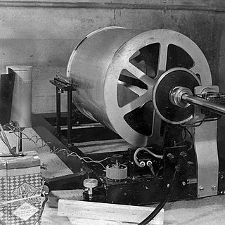
The Wood–Anderson seismometer is a torsion seismometer developed in the United States by Harry O. Wood and John August Anderson in the 1920s to record local earthquakes in southern California. It photographically records the horizontal motion. The seismometer uses a pendulum of 0.8g, its period is 0.8 seconds, its magnification is 2,800 times, and its damping constant is 0.8. Charles Francis Richter developed the Richter magnitude scale using the Wood–Anderson seismometer.
References
- 1 2 3 4 5 6 7 "Të gjitha tërmetet që kanë ndodhur në territorin e Kosovës -". Revista Monitor. September 24, 2019.
- ↑ "USGS Istog earthquake".
- ↑ "2002 Gjilan Earthquake USGS".
- ↑ "An earthquake measuring 5 on the Richter scale rocked..." UPI.
- ↑ "Kopaonik Earthquake USGS".
- 1 2 3 4 5 6 7 8 9 10 Mustafa, Shemsi. "Seismic Activity and Essential Seismological Characteristics of the Kosovo Territory".
- ↑ "USGS – 2013 Vushtri Earthquake".