
Norway is a country located in Northern Europe in the northern and western parts of the Scandinavian Peninsula. The majority of the country borders water, including the Skagerrak inlet to the south, the North Sea to the southwest, the North Atlantic Ocean to the west, and the Barents Sea to the north. It has a land border with Sweden to the east; to the northeast it has a shorter border with Finland and an even shorter border with Russia.

Bremanger is a municipality in Vestland county, Norway. The village of Svelgen is the administrative centre of the municipality. Other villages include Bremanger, Berle, Davik, Isane, Kalvåg, Svelgen, Rugsund, and Ålfoten. Bremanger is the only municipality in Vestland, which is located in two districts. The northern and eastern parts comprising the villages of Oldeide, Berle, Rugsund, Davik, Isane, and Ålfoten is located in the Nordfjord region, while the villages of Bremanger, Kalvåg, Svelgen, Sørgulen, and Botnane are located in the Sunnfjord region. Politically, the municipality works with the Nordfjord region in the council of Nordfjord municipalities.

Meløy is a municipality in Nordland county, Norway. It is part of the Salten traditional region. The administrative centre of the municipality is the village of Ørnes. Other villages include Eidbukta, Neverdal, Glomfjord, Halsa, Reipå, Støtt, and Ågskardet.

The Hardangerfjord is the fifth longest fjord in the world, and the second longest fjord in Norway. It is located in Vestland county in the Hardanger region. The fjord stretches 179 kilometres (111 mi) from the Atlantic Ocean into the mountainous interior of Norway along the Hardangervidda plateau. The innermost point of the fjord reaches the town of Odda.
Jostedalsbreen National Park is a national park in Norway that encompasses the largest glacier on the European mainland, Jostedalsbreen. The park was established by royal decree on 25 October 1991, and then in 1998, it was enlarged to the northwest. The park now covers 1,310 square kilometres (510 sq mi), with the glaciers covering about 800 square kilometres (310 sq mi) of the park.

An ice field is a mass of interconnected valley glaciers on a mountain mass with protruding rock ridges or summits. They are often found in the colder climates and higher altitudes of the world where there is sufficient precipitation for them to form. The higher peaks of the underlying mountain rock that protrude through the icefields are known as nunataks. Ice fields are larger than alpine glaciers, but smaller than ice caps and ice sheets. The topography of ice fields is determined by the shape of the surrounding landforms, while ice caps have their own forms overriding underlying shapes.

Folgefonna is a collective term for three plateau glaciers in the Hardanger region of Vestland county, Norway. They are located on the Folgefonna peninsula in the municipalities of Ullensvang, Kvinnherad, and Etne. The three glaciers are:
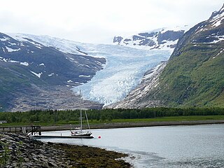
Svartisen is a collective term for two glaciers located in Nordland county in northern Norway. It is part of Saltfjellet-Svartisen National Park, located in the Saltfjell mountain range. The glaciers are located in the municipalities of Beiarn, Meløy, Rana, and Rødøy. Svartisen consists of two separate glaciers that are separated by the 1-kilometre (0.62 mi) long Vesterdalen valley. The two glaciers are:

Søndre Folgefonna is the third largest glacier in mainland Norway, and is the largest of the three glaciers constituting Folgefonna. The glacier is located at the base of the Folgefonna peninsula in Vestland county in the border of the municipalities of Ullensvang, Etne, and Kvinnherad. The highest point on the glacier is 1,660 m (5,446 ft) above sea level and its lowest point is 490 m (1,608 ft) above sea level. The glacier is located inside Folgefonna National Park.
Blåmannsisen (Norwegian) or Ålmåjalosjiegņa (Lule Sami) is the fifth-largest glacier in mainland Norway. It is located on the border of the municipalities of Fauske and Sørfold in Nordland county, Norway—just 2 kilometres (1.2 mi) west of the border with Sweden.

Hardangerjøkulen is the sixth largest glacier in mainland Norway. It is located in the municipalities of Eidfjord and Ulvik in Vestland county. It is located about 16 kilometres (9.9 mi) northeast of the village of Eidfjord, about 5 kilometres (3.1 mi) south of the village of Finse, and about 20 kilometres (12 mi) west of the village of Haugastøl.

Myklebustbreen or Snønipbreen is the seventh largest glacier in mainland Norway. It is located in the municipalities of Nordfjord, Gloppen, and Stryn in Vestland county. Its highest point is located just below the nunatak Snønipa, with an altitude of 1,827 metres (5,994 ft). The lowest point on the glacier is at an elevation of 890 metres (2,920 ft) above sea level.

Okstindbreen is the eighth-largest glacier in mainland Norway. The 46-square-kilometre (18 sq mi) glacier lies in the Okstindan mountain range in the municipality of Hemnes in Nordland county.

Øksfjordjøkelen (Norwegian) or Ákšovuonjiehkki (Northern Sami) is the ninth largest glacier in mainland Norway. The glacier is located in Troms og Finnmark county. The 42-square-kilometre (16 sq mi) glacier lies in both Loppa and Kvænangen municipalities.
Harbardsbreen is the 10th largest glacier in mainland Norway. It is located on the south side of the Tverrådalskyrkja mountain in the Breheimen mountain range in the municipality of Luster in Vestland county, Norway.
The Sulitjelma Glacier is one of the largest glaciers in mainland Norway. The 24-square-kilometre (9.3 sq mi) glacier is located in mostly in Norway, but the eastern part crosses over into Sweden. The Norwegian part is in Fauske Municipality in Nordland county, about 40 kilometres (25 mi) east of the town of Fauske. The Swedish part lies on the border of Arjeplog Municipality and Jokkmokk Municipality in Norrbotten County. When the whole glacier is considered, it is the largest glacier in Sweden.
Gihtsejiegņa or Gihtsejiegŋa is one of the largest glaciers in mainland Norway. It is located in the municipality of Narvik in Nordland county, about 20 kilometres (12 mi) southeast of the village of Kjøpsvik, on the border with Sweden. The name of the glacier comes from the Lule Sami language. The elevation of the glacier ranges from 1,500 to 870 metres above sea level. The highest point of the glacier sits right below the summit of the 1,520-metre (4,990 ft) tall Bjørntoppen.

Saltfjellet is a mountain area in Nordland county, Norway that separates the two regions of Helgeland and Salten. It is also a cultural border between the Southern and Central parts of Sápmi.
Troms og Finnmark was a county in northern Norway that was established on 1 January 2020 as the result of a regional reform. It was the largest county by area in Norway, encompassing about 75,000 square kilometres (29,000 sq mi), and was formed by the merger of the former Finnmark and Troms counties in addition to Tjeldsund Municipality from Nordland county.

