Blåmannsisvatnet is a lake in Fauske Municipality in Nordland county, Norway. The 3.76-square-kilometre (1.45 sq mi) lake lies on the southeast edge of the large Blåmannsisen glacier, about 35 kilometres (22 mi) east of the town of Fauske. The border with Sweden is located about 6 kilometres (3.7 mi) east of the lake.

Gresvatnet (Norwegian) or Gräsvattnet (Swedish) or Graesiejaevrie (Southern Sami) is a lake on the border between Norway and Sweden. Most of the lake lies in Hemnes Municipality in Nordland county (Norway) and then a small portion crosses the border into Storuman Municipality in Västerbotten County (Sweden). The lake lies about 25 kilometres (16 mi) east of the village of Korgen, and just a few kilometres northeast of the mountain Oksskolten and the Okstindbreen glacier. The lake is one of the upper reservoirs for the Bjerka Hydroelectric Power Station.
Låmivatnet or Loamevatnet (Norwegian) or Loamejávrre (Lule Sami) is a lake in Fauske Municipality in Nordland county, Norway. The 11.43-square-kilometre (4.41 sq mi) lake lies about 5 kilometres (3.1 mi) east of the village of Sulitjelma, just south of the Sulitjelma Glacier and north of Junkerdal National Park. The border with Sweden is 3 kilometres (1.9 mi) east of the lake. The Lomi Hydroelectric Power Station uses the lake as a reservoir.
Sisovatnet (Norwegian) or Sijdasjávrre (Lule Sami) is a lake that lies in the municipality of Sørfold in Nordland county, Norway. It is located in the southeastern part of the municipality of Sørfold, about 10 kilometres (6.2 mi) east of the village of Straumen. The lake Rundvatnet lies immediately east of Sisovatnet.
Aursjoen is a lake in Skjåk Municipality in Innlandet county, Norway. The 7.3783-square-kilometre (2.8488 sq mi) lake sits at an elevation of 1,098 metres (3,602 ft) above sea level. The lake lies about 5 kilometres (3.1 mi) north of the village of Bismo. The mountain Horrungen lies just east of the lake. Reinheimen National Park lies just north of the lake.
Kolsvatnet is a lake in the municipality of Valle in Agder county, Norway. It is located about 14 kilometres (8.7 mi) southwest of the village of Valle and about 15 kilometres (9.3 mi) northwest of the village of Rysstad. The lake is located south of the lake Botnsvatnet, east of the mountain Urddalsknuten, and northeast of the lake Rosskreppfjorden. The lake has an area of 2.72 square kilometres (1.05 sq mi) and sits at an elevation of 1,034 metres (3,392 ft) above sea level.
Holmevatnet or Holmevatn is a lake in the Setesdalsheiene area of Norway. It is located in the mountains on the border of the municipalities of Bykle in Agder county and Suldal in Rogaland county. The 4.76-square-kilometre (1.84 sq mi) lake lies just west of the lake Store Urevatn and to the northeast of the lake Blåsjø. The nearest villages are Berdalen in Bykle, about 20 kilometres (12 mi) to the east and Suldalsosen, about 30 kilometres (19 mi) to the west. The mountain Kaldafjellet lies about 6 kilometres (3.7 mi) north of the lake.
Botnsvatnet or Botsvatnet is a lake in the municipality of Valle in Agder county, Norway. The 5.61-square-kilometre (2.17 sq mi) lake is located just north of the lakes Rosskreppfjorden and Kolsvatnet and the mountain Urddalsknuten, and it lies to the southeast of the mountain Bergeheii. The village of Valle is located about 14 kilometres (8.7 mi) to the east of the lake. The lake sits at an elevation of 1,020 metres (3,350 ft) above sea level.

Oppstrynsvatn is a lake in the municipality of Stryn in Vestland county, Norway. It is located about 8 kilometres (5.0 mi) east of the village of Stryn. The villages of Flo, Oppstryn, and Erdal are located on the shores of the lake.

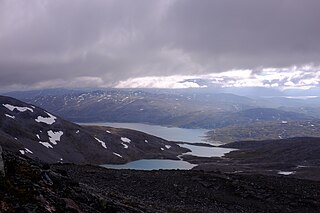
Prestesteinsvatnet is a lake in Luster Municipality in Vestland county, Norway, with a small part of the lake crossing over into the neighboring Lom Municipality in Innlandet county. The 4.12-square-kilometre (1,020-acre) lake sits at an elevation of 1,357 metres (4,452 ft) above sea level. It lies along the south side of the Sognefjellsvegen road, just to the north of the mountain Fannaråki and the Fannaråkbreen glacier. The lake sits just outside the borders of Jotunheimen National Park. The village of Skjolden lies about 20 kilometres (12 mi) to the southwest of the lake.
Austdalsvatnet is a lake in the northwestern part of Luster Municipality in Vestland county, Norway. It is located in the Breheimen mountain range at the end of the Austdalsbreen glacier, just north of the lake Styggevatnet. It is about 10 kilometres (6.2 mi) east of Lodalskåpa and Brenibba, in the Jostedalsbreen glacier. The water is regulated by a dam on lake Styggevatnet and it empties into the Jostedøla river which flows south into the Gaupnefjord.

Lovatnet is a lake in the municipality of Stryn in Vestland county, Norway. It is located about 2 kilometres (1.2 mi) southeast of the village of Loen and about 6 kilometres (3.7 mi) east of the village of Olden. The lake lies just 2 kilometres (1.2 mi) southwest of the mountain Skåla. The water from the lake flows down from the mountains; especially from the Jostedalsbreen and Tindefjellbreen glaciers. It then flows out through the Loelva river into the Nordfjorden.

The Gaula is a river located in the Sunnfjord region of Vestland county, Norway. The 63-kilometre (39 mi) long river is the central part of the Gaularvassdraget watershed basin which covers about 626 square kilometres (242 sq mi) across the municipalities of Sunnfjord and Sogndal. The river is a good salmon fishing river. The river runs across the whole municipality of Gaular, and the river is the namesake of the municipality.
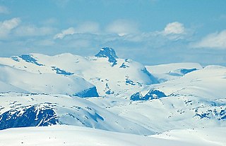
Lodalskåpa is the highest nunatak on the Norwegian glacier Jostedalsbreen. It is located on the border between the municipalities of Stryn and Luster in Vestland county, Norway, within Jostedalsbreen National Park.
Besshø or Besshøe is a mountain in Vågå Municipality in Innlandet county, Norway. The 2,258-metre (7,408 ft) tall mountain is located in the Jotunheimen mountains within Jotunheimen National Park. The mountain sits about 48 kilometres (30 mi) southwest of the village of Vågåmo and about 28 kilometres (17 mi) northwest of the village of Beitostølen. The mountain is surrounded by several other notable mountains including Kollhøin to the north, Veslfjellet and Besseggen to the southeast, Bukkehåmåren and Eggi to the south, and Gloptinden to the west.

Styggevatnet is a glacial lake from the glacier Jostedalsbreen in Luster Municipality in Vestland county, Norway. The lake lies just southeast of the lake Austdalsvatnet. The lake is regulated by a dam and it empties into the river Jostedøla. The lake is about 10 kilometres (6.2 mi) to the east of Lodalskåpa and Brenibba in Jostedalsbreen National Park.
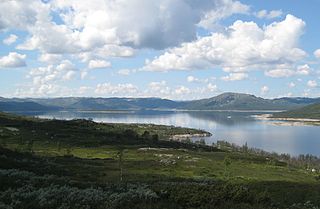
Songavatnet is a lake in Vinje Municipality in Telemark county, Norway. It has a surface area of 29.86 square kilometres (11.53 sq mi) and lies at an elevation of 974 metres (3,196 ft). The lake lies just south of the border of Hardangervidda National Park and just southeast of the mountain Vassdalseggi. The villages of Haukeli and Edland are both located about 9 kilometres (5.6 mi) to the south of the lake and the village of Arabygdi lies about 10 kilometres (6.2 mi) to the southeast of the lake. The lake flows out into the river Songa which flows to the southeast into the nearby lake Totak.

Ångardsvatnet is a lake in the municipality of Oppdal in Trøndelag county, Norway. The 3.24-square-kilometre (1.25 sq mi) lake lies in the Storlidalen valley, about 13 kilometres (8.1 mi) northwest of the village of Lønset and about 35 kilometres (22 mi) west of the village of Oppdal. The lake is about 4.8 kilometres (3.0 mi) long and about 950 metres (3,120 ft) wide. It is surrounded by the Trollheimen mountain range including the mountains Gråfjellet, Kråkvasstind, and Lorthøa to the south and Bårdsgardskammen and Okla to the north. The lake Gjevillvatnet lies in the next valley to the north of Ångardsvatnet.

The Grovabreen glacier is located in Vestland county, Norway. It covers an area of about 20 square kilometres (7.7 sq mi) in Sunnfjord Municipality in the Sunnfjord region. The highest point on the glacier sits at an elevation of 1,636 metres (5,367 ft) above sea level. The glacier is part of Jostedalsbreen National Park, just south of the lake Jølstravatnet. The village of Skei lies about 8 kilometres (5.0 mi) north of the glacier and the village of Haukedalen lies about 9 kilometres (5.6 mi) southwest of the glacier. The Jostefonn glacier lies about 5 kilometres (3.1 mi) to the south of this glacier; both are located at the north end of the Gaularfjellet mountains.
Haukedalen is a village in Sunnfjord Municipality in Vestland county, Norway. The village is located in the Haukedalen valley at the northwestern end of the lake Haukedalsvatnet. The village lies in a fairly remote valley surrounded by the Gaularfjellet mountains. The town of Førde lies about 35 kilometres (22 mi) to the west. Haukedalen Church is located in the village. The glaciers Grovabreen and Jøstafonn are both about 10 kilometres (6.2 mi) to the northeast and east respectively.