Svalbard, also known as Spitsbergen, or Spitzbergen, is a Norwegian archipelago in the Arctic Ocean. North of mainland Europe, it is about midway between the northern coast of Norway and the North Pole. The islands of the group range from 74° to 81° north latitude, and from 10° to 35° east longitude. The largest island is Spitsbergen, followed by Nordaustlandet and Edgeøya. The largest settlement is Longyearbyen.

In glaciology, an ice cap is a mass of ice that covers less than 50,000 km2 (19,000 sq mi) of land area. Larger ice masses covering more than 50,000 km2 (19,000 sq mi) are termed ice sheets.

Knut Olai Knutsen Bjørlykke was a Norwegian geologist and sedimentologist.

Sørkapp Land is the land area south of Hornsund, at the southern part of Spitsbergen, Svalbard. Two glaciers, Hornbreen and Hambergbreen, divide Sørkapp Land from Torell Land.

Torell Land is a land area at the southeast part of Spitsbergen, Svalbard. It is named after Otto Martin Torell. Two glaciers, Hornbreen and Hambergbreen, divide Torell Land from Sørkapp Land.
Barentsjøkulen is a glacier on Barentsøya, Svalbard. The glacier covers an area of about 571 km2 (220 sq mi). It is named after the Barents Island, which again is named after Dutch explorer Willem Barentsz. Barents Island is on the Barents Sea.

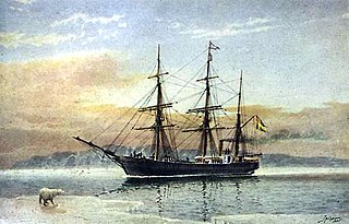
Vegafonna is an ice cap in Gustav Adolf Land on Nordaustlandet in the Svalbard archipelago. It is located on the peninsula Scaniahalvøya, between the bay Palanderbukta to the north and Torellneset to the south. The glacier is named after the vessel SS Vega. Further west on the peninsula is the ice cap Glitnefonna.
Valhallfonna is an ice cap in Ny-Friesland at Spitsbergen, Svalbard. It is located west of Hinlopen Strait and northeast of Åsgardfonna. The glacier covers an area of about 1,000 km2.
Kjerulfbreen is a glacier in Oscar II Land at Spitsbergen, Svalbard. It has a length of about 7.5 kilometers, and is debouching into the Trygghamna bay at the northern side of Isfjorden. The glacier is named after Norwegian geologist Theodor Kjerulf.
Woodfjorddalen is a valley in Andrée Land at Spitsbergen, Svalbard. It forms a southeastward continuation of the fjord Woodfjorden. The upper part of the valley is covered by the glacier Abrahamsenbreen. At the lower part of the valley is the flat sand and clay area Poninskiøyra and the hill Tantalushaugen. A side valley to the south is Piræusdalen, six kilometers from the head of Woodfjorden. North of the valley is the mountain group Vaktarfjella, with a length of about eleven kilometers.
Keilhaubreen is a glacier in Sørkapp Land at Spitsbergen, Svalbard. It has a length of about five kilometers and is located north of Keilhaufjellet, flowing from Sørkappfonna towards the eastern coast of Spitsbergen. The glacier is named after Norwegian geologist Baltazar Mathias Keilhau. To the south of the glacier is the bay Austerbogen.
Brageneset is an island at Nordaustlandet, Svalbard. It is located at the mouth of Wahlenbergfjorden. The ice cap Vestfonna has the glacier arm Bragebreen which debouches east of Brageneset, and another glacier arm, Gimlebreen debouches into Hinlopen Strait north of Brageneset.
Freemanbreen is a glacier on Barentsøya, Svalbard. It is an offshoot of Barentsjøkulen, reaching down to the sea in the southern direction, into Freeman Strait. The glacier is named after British Alderman Ralph Freeman. The mountain of Buklerimen separates Freemanbreen from the glacier of Hübnerbreen.
Smeerenburgfjorden is a fjord in Albert I Land at Spitsbergen, Svalbard. It has a length of about twenty kilometers and a width of about four kilometers. The fjord is named after the old whaling settlement Smeerenburg, which was situated at the southern part of Amsterdam Island. The fjord is located between the peninsulas of Vasahalvøya and Reuschhalvøya, and connects westwards through the straits of Danskegattet and Sørgattet. The Smeerenburgbreen glacier debouches into the head of the fjord.

Tinayrebreen is a glacier in Haakon VII Land at Spitsbergen, Svalbard. It has a length of about ten kilometers, and extends from the glacier cap of Isachsenfonna to Möllerfjorden, where it debouches into the bay of Tinayrebukta. The glacier is named after French painter Jean Paul Louis Tinayre.
Hayesbreen is a glacier in Sabine Land at Spitsbergen, Svalbard. It is named after American politician and Arctic explorer Isaac Israel Hayes. The glacier has a length of about eighteen kilometers, and debouches into the bay of Mohnbukta. Surrounding mountains are Aagaardfjellet to the north, Jebensfjellet to the south, and Panofskyfjellet where Hayesbreen joins the glacier of Königsbergbreen.
Hedgehogfonna is a glacier field in Sørkapp Land at Spitsbergen, Svalbard. It is located west of the mountain of Hedgehogfjellet, and is separated from the glacier of Vasil'evbreen by Skilfonna.

Liestølbreen is a glacier complex in Torell Land at Spitsbergen, Svalbard. It is named after Norwegian glaciologist Olav Liestøl. The glacier is situated between the mountains of Arrheniusfjellet and Wijkberget. The glaciers of Krøkjebreen and Glasiologbreen belong to the Liestølbreen complex.

Biscayarfonna is an ice cap in Spitsbergen, Svalbard. It has an elevation of 467 m (1,532 ft), and is located on the Haakon VII Land peninsula between Raudfjorden in the west and Breibogen bay in the east. This ice cap is named after Biscay in honour of the Basque whalers who hunted at Spitsbergen in the 17th and 18th centuries.

Bjørlykkebreen is a glacier in Albert I Land, Spitsbergen, Svalbard. It is a tributary of Lillehöökbreen, and is debouching into the Lilliehöökfjorden. The glacier is named after Norwegian geologist Knut Olai Bjørlykke following a proposal in 1912 by Adolf Hoel who had traversed the glacier in 1909 together with Olaf Holtedahl.


