A list of the heritage-listed sites in West End, City of Brisbane, Queensland, Australia.
- 19 Bank Street: Astrea [1] [2]
- 96 Boundary Street: West End Police Station [3]
- 111 Boundary Street: Peters Factory [4]
- 137 Boundary Street: Boundary Hotel [5]
- 141 Boundary Street: Westella [6]
- 142 Boundary Street: Shop [7]
- 173 Boundary Street: Pearsons Buildings [8]
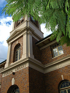
- 178 Boundary Road: Kurilpa Library [9] [10]
- 197 Boundary Street: Row of shops [11]
- 219 Boundary Street: Timber cottage [12]
- 223 Boundary Street: Glen Finn Villa [13]
- 225 Boundary Street: Greek Evangelical Church [14]
- 227 Boundary Street: Timber-and-tin residence [15]
- 235 Boundary Street: Gorman Brothers Grocery Store [16]
- 253 Boundary Street: Bungalow style residence [17]
- Dornoch Terrace: Dornoch Terrace Bridge [18] [19]
- 19 Dornoch Terrace: former Methodist Church [20]
- 22 Dornoch Terrace: Flamingo House [21]
- 47 Dornoch Terrace: St Francis School & Church [22]
- 51 Dornoch Terrace: St Francis Convent [23]
- 59 Dornoch Terrace: St Francis Presbytery [24]
- 12 Exeter Street: Two-storey brick terrace house [25]
- 9 Gray Road: House "Hillside" [26]
- 15 Gray Road: Wanda Walha [27] [28]
- 37 Gray Road: Nassagaweya [29] [30]
- 31 Hardgrave Road: Drayton Court [31]
- 61 Hardgrave Road: Rialto Theatre [32]
- 68 Hill end Terrace: Orleigh Park [33]
- 22 Jane Street: Walmar [34]
- 18 Mitchell Street: Hill End Child Care Centre (former church) [35]
- 222 Montague Road: former Stronach's Workshop [36]
- 277 Montague Road: Davies Park [37]
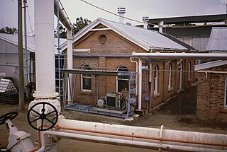
- 277 Montague Road: Gas Stripping Tower [38] [39]
- 317 Montague Road: West End Gasworks Distribution Centre [40]
- 321 Montague Road: West End Gasworks [41]
- 406 Montague Road: Thomas Dixon Centre [42] [43]
- 439 Montague Road: former Dixon's Tannery [44]
- 12 Princhester Street: Islamic Centre of West End [45]
- 14 Sussex Street: Carnoch [46]
- 16 Sussex Street: Norwich [47]
- 30 Sussex Street: Brighton Terrace [48] [49]
- 24 Vulture Street: West End State School [50]
- 61 Vulture Street: Shop and Residence [51]
- 79 Vulture Street: former Marshalls Butchers [52]
- 113 Vulture Street: West End Uniting Church & Hall [53]