List of islands in the Houtman Abrolhos

Last updated

Houtman Abrolhos from space Houtman Abrolhos.jpg
Houtman Abrolhos from space

The Houtman Abrolhos is an island chain off the west coast of Australia. It is widely reported that the Houtman Abrolhos contains 122 islands, but only 93 islands had gazetted names in 1996. In the gazetteer of 2011 Hartley Island appears no more, but Barge Rock, Second Sister and Shag Rock appear, which raises the number of gazetted names to 96 (30 in the Wallabi Group, 38 in the Pelsaert Group and 28 in the Easter Group). [1]

In addition to the gazetted islands, six island groups have been gazetted. The three main groups are the Wallabi Group, the Easter Group and the Pelsaert Group. In addition, the Easter Group contains a group known as the Eastern Islands, and the Pelsaert group contains groups known as the Mangrove Group and the Numbered Islands. [2]

The Inventory of the Land Conservation Values of the Houtman Abrolhos mentions many more unofficially named islets, 16 in the Wallabi Group, 26 in the Eastern Group and 15 in the Pelsaert Group, plus the subgroups of the Jackson Islets (7 islets without individual names or numbers) and The Coral Patches (13 islets without individual names or numbers), also in the Pelsaert Group. [3]

This makes for a total of 173 known islands, islets and above-water rocks with land area in the Houtman Abrolhos.

This list is complete with respect to the 1996 Gazetteer of Australia. [2]

NameArea
m2
CoordinatesGroup, subgroup
1 Island 17661 28°54′34″S113°52′55″E / 28.90944°S 113.88194°E / -28.90944; 113.88194 Pelsaert Group, Numbered Islands
2 Island 3207 28°54′34″S113°52′42″E / 28.90944°S 113.87833°E / -28.90944; 113.87833 Pelsaert Group, Numbered Islands
3 Island 17166 28°54′24″S113°52′16″E / 28.90667°S 113.87111°E / -28.90667; 113.87111 Pelsaert Group, Numbered Islands
7 Island 4419 28°54′22″S113°51′21″E / 28.90611°S 113.85583°E / -28.90611; 113.85583 Pelsaert Group, Numbered Islands
8 Island 6154 28°53′56″S113°51′36″E / 28.89889°S 113.86000°E / -28.89889; 113.86000 Pelsaert Group, Numbered Islands
Akerstrom Island 12073 28°28′30″S113°41′51″E / 28.47500°S 113.69750°E / -28.47500; 113.69750 Wallabi Group
Alcatraz Island 716. 28°27′43″S113°43′18″E / 28.46194°S 113.72167°E / -28.46194; 113.72167 Wallabi Group
Alexander Island 128610 28°40′26″S113°49′44″E / 28.67389°S 113.82889°E / -28.67389; 113.82889 Easter Group
Arthur Island ... 28°53′55″S114°0′12″E / 28.89861°S 114.00333°E / -28.89861; 114.00333 Pelsaert Group
Barge Rock ... 28°27′2″S113°43′17″E / 28.45056°S 113.72139°E / -28.45056; 113.72139 Wallabi Group
Basile Island ... 28°52′33″S113°57′38″E / 28.87583°S 113.96056°E / -28.87583; 113.96056 Pelsaert Group
Beacon Island ... 28°28′35″S113°47′2″E / 28.47639°S 113.78389°E / -28.47639; 113.78389 Wallabi Group
Burnett Island ... 28°52′22″S113°57′47″E / 28.87278°S 113.96306°E / -28.87278; 113.96306 Pelsaert Group
Burton Island ... 28°51′59″S113°59′6″E / 28.86639°S 113.98500°E / -28.86639; 113.98500 Pelsaert Group
Bushby Island ... 28°43′25″S113°47′7″E / 28.72361°S 113.78528°E / -28.72361; 113.78528 Easter Group
Bynoe Island ... 28°39′54″S113°52′31″E / 28.66500°S 113.87528°E / -28.66500; 113.87528 Easter Group, Eastern Islands
Campbell Island ... 28°41′44″S113°50′5″E / 28.69556°S 113.83472°E / -28.69556; 113.83472 Easter Group
Coronation Island ... 28°52′14″S113°59′7″E / 28.87056°S 113.98528°E / -28.87056; 113.98528 Pelsaert Group
Crake Island ... 28°44′31″S113°48′57″E / 28.74194°S 113.81583°E / -28.74194; 113.81583 Easter Group
Dakin Island ... 28°28′37″S113°48′25″E / 28.47694°S 113.80694°E / -28.47694; 113.80694 Wallabi Group
Davis Island (5 Island)... 28°54′53″S113°52′33″E / 28.91472°S 113.87583°E / -28.91472; 113.87583 Pelsaert Group, Numbered Islands
Dicks Island ... 28°29′51″S113°45′56″E / 28.49750°S 113.76556°E / -28.49750; 113.76556 Wallabi Group
Disappearing Island ... 28°47′3″S113°44′23″E / 28.78417°S 113.73972°E / -28.78417; 113.73972 Easter Group
Diver Island ... 28°52′2″S113°58′20″E / 28.86722°S 113.97222°E / -28.86722; 113.97222 Pelsaert Group
Dry Island ... 28°44′22″S113°46′43″E / 28.73944°S 113.77861°E / -28.73944; 113.77861 Easter Group
East Wallabi Island ... 28°26′23″S113°43′33″E / 28.43972°S 113.72583°E / -28.43972; 113.72583 Wallabi Group
Eastern Island ... 28°27′55″S113°48′42″E / 28.46528°S 113.81167°E / -28.46528; 113.81167 Wallabi Group
Eight Island ... 28°53′56″S113°51′36″E / 28.89889°S 113.86000°E / -28.89889; 113.86000 Pelsaert Group
Far Island ... 28°27′40″S113°48′19″E / 28.46111°S 113.80528°E / -28.46111; 113.80528 Wallabi Group
First Sister ... 28°28′39″S113°44′33″E / 28.47750°S 113.74250°E / -28.47750; 113.74250 Wallabi Group
Foale Island ... 28°52′45″S114°0′20″E / 28.87917°S 114.00556°E / -28.87917; 114.00556 Pelsaert Group
Gaze Island ... 28°51′50″S113°59′25″E / 28.86389°S 113.99028°E / -28.86389; 113.99028 Pelsaert Group
Gibson Island ... 28°41′13″S113°49′40″E / 28.68694°S 113.82778°E / -28.68694; 113.82778 Easter Group
Gilbert Island ... 28°40′5″S113°49′34″E / 28.66806°S 113.82611°E / -28.66806; 113.82611 Easter Group
Gregory Island ... 28°53′55″S114°0′19″E / 28.89861°S 114.00528°E / -28.89861; 114.00528 Pelsaert Group
Gun Island ... 28°53′17″S113°51′26″E / 28.88806°S 113.85722°E / -28.88806; 113.85722 Pelsaert Group
Hall Island ... 28°28′18″S113°48′36″E / 28.47167°S 113.81000°E / -28.47167; 113.81000 Wallabi Group
Helms Island ... 28°40′10″S113°51′38″E / 28.66944°S 113.86056°E / -28.66944; 113.86056 Easter Group, Eastern Islands
Hummock Island ... 28°48′2″S114°2′20″E / 28.80056°S 114.03889°E / -28.80056; 114.03889 Pelsaert Group
Iris Refuge Island ... 28°52′48″S114°0′16″E / 28.88000°S 114.00444°E / -28.88000; 114.00444 Pelsaert Group
Jackson Island ... 28°52′17″S114°0′10″E / 28.87139°S 114.00278°E / -28.87139; 114.00278 Pelsaert Group
Joe Smith Island ... 28°40′55″S113°51′28″E / 28.68194°S 113.85778°E / -28.68194; 113.85778 Easter Group, Eastern Islands
Jon Jim Island ... 28°59′14″S113°57′34″E / 28.98722°S 113.95944°E / -28.98722; 113.95944 Pelsaert Group
Keru Island ... 28°43′34″S113°49′57″E / 28.72611°S 113.83250°E / -28.72611; 113.83250 Easter Group
Lagoon Island ... 28°52′22″S113°59′39″E / 28.87278°S 113.99417°E / -28.87278; 113.99417 Pelsaert Group
Leo Island ... 28°41′22″S113°51′36″E / 28.68944°S 113.86000°E / -28.68944; 113.86000 Easter Group, Eastern Islands
Little North Island ... 28°37′51″S113°52′53″E / 28.63083°S 113.88139°E / -28.63083; 113.88139 Easter Group, Eastern Islands
Little Pigeon Island ... 28°27′49″S113°43′20″E / 28.46361°S 113.72222°E / -28.46361; 113.72222 Wallabi Group
Little Rat Island ... 28°43′41″S113°47′7″E / 28.72806°S 113.78528°E / -28.72806; 113.78528 Easter Group
Little Roma Island ... 28°44′7″S113°46′51″E / 28.73528°S 113.78083°E / -28.73528; 113.78083 Easter Group
Long Island ... 28°28′20″S113°46′21″E / 28.47222°S 113.77250°E / -28.47222; 113.77250 Wallabi Group
Marinula Island ... 28°28′31″S113°41′57″E / 28.47528°S 113.69917°E / -28.47528; 113.69917 Wallabi Group
Middle Island ... 28°54′31″S113°54′36″E / 28.90861°S 113.91000°E / -28.90861; 113.91000 Pelsaert Group
Morley Island ... 28°44′47″S113°48′45″E / 28.74639°S 113.81250°E / -28.74639; 113.81250 Easter Group
Murray Island ... 28°53′53″S113°53′47″E / 28.89806°S 113.89639°E / -28.89806; 113.89639 Pelsaert Group
Newbold Island ... 28°52′54″S114°0′19″E / 28.88167°S 114.00528°E / -28.88167; 114.00528 Pelsaert Group
Newman Island ... 28°51′48″S113°59′42″E / 28.86333°S 113.99500°E / -28.86333; 113.99500 Pelsaert Group
Nook Island ... 28°51′58″S113°59′57″E / 28.86611°S 113.99917°E / -28.86611; 113.99917 Pelsaert Group
North Island ... 28°18′9″S113°35′41″E / 28.30250°S 113.59472°E / -28.30250; 113.59472 Wallabi Group
Oystercatcher Island ... 28°27′48″S113°42′47″E / 28.46333°S 113.71306°E / -28.46333; 113.71306 Wallabi Group
Pelican Island ... 28°27′36″S113°40′34″E / 28.46000°S 113.67611°E / -28.46000; 113.67611 Wallabi Group
Pelsaert Island ... 28°55′45″S113°58′27″E / 28.92917°S 113.97417°E / -28.92917; 113.97417 Pelsaert Group
Pigeon Island ... 28°27′18″S113°43′34″E / 28.45500°S 113.72611°E / -28.45500; 113.72611 Wallabi Group
Plover Island ... 28°28′5″S113°42′43″E / 28.46806°S 113.71194°E / -28.46806; 113.71194 Wallabi Group
Post Office Island ... 28°51′53″S113°58′28″E / 28.86472°S 113.97444°E / -28.86472; 113.97444 Pelsaert Group
Rat Island ... 28°42′56″S113°47′2″E / 28.71556°S 113.78389°E / -28.71556; 113.78389 Easter Group
Robertson Island ... 28°52′58″S114°0′20″E / 28.88278°S 114.00556°E / -28.88278; 114.00556 Pelsaert Group
Roma Island ... 28°43′57″S113°47′6″E / 28.73250°S 113.78500°E / -28.73250; 113.78500 Easter Group
Rotondella Island ... 28°52′21″S113°59′45″E / 28.87250°S 113.99583°E / -28.87250; 113.99583 Pelsaert Group
Sandy Island ... 28°46′31″S113°47′8″E / 28.77528°S 113.78556°E / -28.77528; 113.78556 Easter Group
Sandy Island ... 28°52′22″S113°52′35″E / 28.87278°S 113.87639°E / -28.87278; 113.87639 Pelsaert Group
Saville-Kent Island ... 28°27′56″S113°48′27″E / 28.46556°S 113.80750°E / -28.46556; 113.80750 Wallabi Group
Seagull Island ... 28°27′29″S113°42′52″E / 28.45806°S 113.71444°E / -28.45806; 113.71444 Wallabi Group
Seal Island ... 28°29′1″S113°48′7″E / 28.48361°S 113.80194°E / -28.48361; 113.80194 Wallabi Group
Second Sister ... 28°29′8″S113°44′25″E / 28.48556°S 113.74028°E / -28.48556; 113.74028 Wallabi Group
Serventy Island ... 28°40′59″S113°49′52″E / 28.68306°S 113.83111°E / -28.68306; 113.83111 Easter Group
Shag Rock ... 28°28′32″S113°42′43″E / 28.47556°S 113.71194°E / -28.47556; 113.71194 Wallabi Group
Shearwater Island ... 28°43′56″S113°49′29″E / 28.73222°S 113.82472°E / -28.73222; 113.82472 Easter Group
Sid Liddon Island (6 Island)... 28°54′40″S113°51′49″E / 28.91111°S 113.86361°E / -28.91111; 113.86361 Pelsaert Group, Numbered Islands
Square Island ... 28°54′7″S113°56′38″E / 28.90194°S 113.94389°E / -28.90194; 113.94389 Pelsaert Group
Stick Island ... 28°53′22″S113°55′11″E / 28.88944°S 113.91972°E / -28.88944; 113.91972 Pelsaert Group
Stokes Island ... 28°40′30″S113°51′2″E / 28.67500°S 113.85056°E / -28.67500; 113.85056 Easter Group, Eastern Islands
Suomi Island ... 28°42′45″S113°50′17″E / 28.71250°S 113.83806°E / -28.71250; 113.83806 Easter Group
Sweet Island (4 Island)... 28°55′1″S113°52′17″E / 28.91694°S 113.87139°E / -28.91694; 113.87139 Pelsaert Group, Numbered Islands
Tapani Island ... 28°40′30″S113°51′16″E / 28.67500°S 113.85444°E / -28.67500; 113.85444 Easter Group, Eastern Islands
Tattler Island ... 28°28′10″S113°42′22″E / 28.46944°S 113.70611°E / -28.46944; 113.70611 Wallabi Group
Third Sister ... 28°29′46″S113°44′23″E / 28.49611°S 113.73972°E / -28.49611; 113.73972 Wallabi Group
Traitors Island ... 28°29′6″S113°46′57″E / 28.48500°S 113.78250°E / -28.48500; 113.78250 Wallabi Group
Travia Island ... 28°51′52″S113°59′12″E / 28.86444°S 113.98667°E / -28.86444; 113.98667 Pelsaert Group
Turnstone Island ... 28°27′9″S113°42′57″E / 28.45250°S 113.71583°E / -28.45250; 113.71583 Wallabi Group
Uncle Margie Island ... 28°52′4″S113°57′59″E / 28.86778°S 113.96639°E / -28.86778; 113.96639 Pelsaert Group
Wann Island ... 28°28′19″S113°45′45″E / 28.47194°S 113.76250°E / -28.47194; 113.76250 Wallabi Group
West Wallabi Island ... 28°28′3″S113°41′12″E / 28.46750°S 113.68667°E / -28.46750; 113.68667 Wallabi Group
White Bank ... 28°42′10″S113°46′30″E / 28.70278°S 113.77500°E / -28.70278; 113.77500 Easter Group
White Island ... 28°40′16″S113°52′30″E / 28.67111°S 113.87500°E / -28.67111; 113.87500 Easter Group, Eastern Islands
Wooded Island ... 28°45′7″S113°48′20″E / 28.75194°S 113.80556°E / -28.75194; 113.80556 Easter Group

See also

Related Research Articles

<i>Batavia</i> (1628 ship) 1628 flagship of the Dutch East India Company

Batavia was a ship of the Dutch East India Company (VOC). Built in Amsterdam in 1628 as the company's new flagship, she sailed that year on her maiden voyage for Batavia, capital of the Dutch East Indies. On 4 June 1629, Batavia was wrecked on the Houtman Abrolhos, a chain of small islands off the western coast of Australia.

Houtman Abrolhos Group of islands and reefs off Western Australia

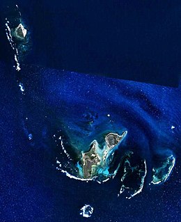
The Houtman Abrolhos is a chain of 122 islands, and associated coral reefs, in the Indian Ocean off the west coast of Australia, about eighty kilometres (50 mi) west of Geraldton, Western Australia. It is the southernmost true coral reef in the Indian Ocean, and one of the highest latitude reef systems in the world. It is one of the world's most important seabird breeding sites, and is the centre of Western Australia's largest single-species fishery, the western rock lobster fishery. It has a small seasonal population of fishermen, and a limited number of tourists are permitted for day trips, but most of the land area is off limits as conservation habitat. It is well known as the site of numerous shipwrecks, the most famous being the Dutch ships Batavia, which was wrecked in 1629, and Zeewijk, wrecked in 1727.

Wallabi Group Islands in Western Australia

The Wallabi Group is the northernmost group of islands in the Houtman Abrolhos off the western coast of Western Australia. it is 58 kilometres from the Australian mainland, and about 9 kilometres from the Easter Group.

Easter Group Islands in the Houtman Abrolhos in Western Australia

The Easter Group is the central of three groups of islands that make up the Houtman Abrolhos island chain. The group measures about 20 kilometres by 12 kilometres, and consists of a number of islands including

Pelsaert Group Islands in Western Australia

The Pelsaert Group is the southernmost of the three groups of islands that make up the Houtman Abrolhos island chain. it consists of a number of islands, the largest of which are Gun Island, Middle Island, and Pelsaert Island. The group is named after a Dutch "opperkoopman" who stranded nearby with the VOC-ship "Batavia" in 1629. The group contains the most southerly true coral reefs in the Indian Ocean. The group is part of the Houtman Abrolhos Important Bird Area, identified as such by BirdLife International because of its importance for supporting large numbers of breeding seabirds.

North Island (Houtman Abrolhos) Island in the Houtman Abrolhos, off the coast of Mid West Western Australia

North Island is the northernmost island in the Houtman Abrolhos, a coral reef archipelago in the Indian Ocean off the coast of Mid West Western Australia. Located about 14 km (9 mi) from the nearest island group, it is one of the largest islands in the Houtman Abrolhos, and one of the few to support dune systems. It has relatively diverse flora dominated by chenopod shrubs and fauna that includes the introduced tammar wallaby, around seven species of reptile, and about 15 resident bird species.

<i>Batavia Road</i> (boat)

Batavia Road was a passenger boat used from 1946 for commercial tourist operation in the Houtman Abrolhos, a group of islands off the coast of Western Australia.

North East Reef Reef in Australia

North East Reef is a reef in the Wallabi Group of the Houtman Abrolhos, in the Indian Ocean off the coast of Western Australia. Located at 28°25′13″S113°48′41″E, it takes its name from the fact that it is situated to the north-east of the main body of islands that makes up the Wallabi Group. The island is part of the Houtman Abrolhos Important Bird Area, identified as such by BirdLife International because of its importance for supporting large numbers of breeding seabirds.

Fish Point (Houtman Abrolhos) Point in the north-eastern corner of East Wallabi Island in the Houtman Abrolhos island chain off the coast of Western Australia

Fish Point is a point in the north-eastern corner of East Wallabi Island in the Houtman Abrolhos island chain off the coast of Western Australia. It is located at 28°25′40″S113°44′34″E. It sits at the foot of Flag Hill, the highest peak on East Wallabi Island, and its western edge looks out onto Turtle Bay.

Gun Island Island in Western Australia

Gun Island is one of the larger islands in the Pelsaert Group of the Houtman Abrolhos, in the Indian Ocean off the west coast of Australia. It is nominally at 28°53′10″S113°51′35″E, about 4 km (2.5 mi) north and east of Half Moon Reef and is a flat limestone outcrop of about 800 by 420 metres in size. The island is part of the Houtman Abrolhos Important Bird Area, identified as such by BirdLife International because of its importance for supporting large numbers of breeding seabirds.

Abrolhos painted buttonquail Subspecies of bird

The Abrolhos painted buttonquail is a subspecies of the painted buttonquail endemic to the Houtman Abrolhos. It is common on North Island, and also occurs on other islands of the Wallabi Group, namely East Wallabi, West Wallabi, Seagull and Pigeon Islands.

In fact the Batavia was wrecked in the Wallabi Group, 60 kilometres (40 mi) to the north. The wreckage seen by the Beagle was either that of the Zeewyk, or the unidentified wreck seen by the Zeewyks crew. The name Batavia Road is thus a misnomer, as are a number of other places named by Stokes, including Pelsaert Island, the Pelsaert Group, and Wreck Point. Stokes' erroneous view was accepted without question for over fifty years, and it has been claimed that the confusion caused the discovery of the Batavia shipwreck to be set back by over a century.

Flag Hill is the highest hill on East Wallabi Island, and the highest point in the Houtman Abrolhos, an archipelago off the coast of Western Australia. It is located in the north-east of the island; its gazetted location is 28°26′7″S113°44′14″E, but in fact it is located somewhat east of there at about 28°26′02″S113°44′18″E. It is about 15 metres (50 ft) high.

Pigeon Island (Houtman Abrolhos)

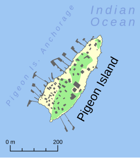
Pigeon Island is a small island located need the middle of the Wallabi Group of the Houtman Abrolhos, an archipelago off the coast of Western Australia. It is almost entirely given over to western rock lobster fishers' camps, and as a result is far more disturbed than most other islands in the archipelago. A nearby island also seasonally populated by fishers is named Little Pigeon Island, hence Pigeon Island is sometimes referred to as "Big Pigeon Island".

Shag Rock is a small rocky island in the Wallabi Group of the Houtman Abrolhos.

East Wallabi Island

East Wallabi Island is an island in the Wallabi Group of the Houtman Abrolhos, located in the Indian Ocean off the west coast of mainland Australia.

West Wallabi Island is an island in the Wallabi Group of the Houtman Abrolhos, in the Indian Ocean off the west coast of mainland Australia.

Pelsaert Island

Pelsaert Island is one of the islands of the Pelsaert Group, which is the southernmost of the three groups of islands that make up the Houtman Abrolhos island chain in Western Australia.

Beacon Island (Houtman Abrolhos) Island in Western Australia

Beacon Island, also known as Batavia's graveyard, is an island on the eastern side of the Wallabi Group at the northern end of the Houtman Abrolhos, in the Indian Ocean, off the coast of Western Australia.

References

Map this section's coordinates using: OpenStreetMap  
Download coordinates as: KML