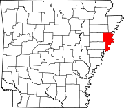
List of lakes in Crittenden County, Arkansas

Last updated
Map all coordinates using: OpenStreetMap  ·  Google Maps
Download coordinates as: KML  ·  GPX

There are at least 41 named lakes and reservoirs in Crittenden County, Arkansas .

Lake A body of relatively still water, in a basin surrounded by land

A lake is an area filled with water, localized in a basin, that is surrounded by land, apart from any river or other outlet that serves to feed or drain the lake. Lakes lie on land and are not part of the ocean, and therefore are distinct from lagoons, and are also larger and deeper than ponds, though there are no official or scientific definitions. Lakes can be contrasted with rivers or streams, which are usually flowing. Most lakes are fed and drained by rivers and streams.

Reservoir A storage space for fluids

A reservoir is, most commonly, an enlarged natural or artificial lake, pond or impoundment created using a dam or lock to store water.

Crittenden County, Arkansas County in the United States

Crittenden County is a county located in the U.S. state of Arkansas. As of the 2010 census, the population was 50,902. The county seat is Marion, and the largest city is West Memphis. Crittenden County is Arkansas's twelfth county, formed October 22, 1825, and named for Robert Crittenden, the first Secretary of the Arkansas Territory.

Contents

Lakes

Horseshoe Lake is the namesake for the community Horseshoe Lake, Arkansas Horseshoe Lake AR 19.jpg
Horseshoe Lake is the namesake for the community Horseshoe Lake, Arkansas

Bushy Lake is a small lake located in Sacramento, California along the American River Parkway. The area is part of an ongoing restoration project, it also provides habitat to wildlife and offers nearby recreation opportunities. The area is prone to drought, erosion, species invasion, fire, and groups of transient populations. In the American River Parkway Plan, the lake is designated as a Nature Study Area and further protected by the Bushy Lake Preservation Act.

Horseshoe Lake, Arkansas Town in Arkansas, United States

Horseshoe Lake is a town in Crittenden County, Arkansas, United States. The population was 292 at the 2010 census.

Reservoirs

See also

Notes

  1. "Beautiful Lake". Geographic Names Information System . United States Geological Survey.
  2. "Benwood Lake". Geographic Names Information System . United States Geological Survey.
  3. "Big Lake". Geographic Names Information System . United States Geological Survey.
  4. "Blackfish Lake". Geographic Names Information System . United States Geological Survey.
  5. "Blue Lake". Geographic Names Information System . United States Geological Survey.
  6. "Brougham Lake". Geographic Names Information System . United States Geological Survey.
  7. "Buck Lake". Geographic Names Information System . United States Geological Survey.
  8. "Bushy Lake". Geographic Names Information System . United States Geological Survey.
  9. "Cane Lake". Geographic Names Information System . United States Geological Survey.
  10. "Copperas Lake". Geographic Names Information System . United States Geological Survey.
  11. "Danner Lake". Geographic Names Information System . United States Geological Survey.
  12. "Dead Timber Lake". Geographic Names Information System . United States Geological Survey.
  13. "Fletcher Lake". Geographic Names Information System . United States Geological Survey.
  14. "Goose Lake". Geographic Names Information System . United States Geological Survey.
  15. "Grassy Lake". Geographic Names Information System . United States Geological Survey.
  16. "Holden Lake". Geographic Names Information System . United States Geological Survey.
  17. "Hood Lake". Geographic Names Information System . United States Geological Survey.
  18. "Hopefield Chute". Geographic Names Information System . United States Geological Survey.
  19. "Hopefield Lake". Geographic Names Information System . United States Geological Survey.
  20. "Horseshoe Lake". Geographic Names Information System . United States Geological Survey.
  21. "Island Forty Chute". Geographic Names Information System . United States Geological Survey.
  22. "Lake David". Geographic Names Information System . United States Geological Survey.
  23. "Lake Deloche". Geographic Names Information System . United States Geological Survey.
  24. "Lewis Lake". Geographic Names Information System . United States Geological Survey.
  25. "Little Grassy Lake". Geographic Names Information System . United States Geological Survey.
  26. "Long Pond". Geographic Names Information System . United States Geological Survey.
  27. "Marion Lake". Geographic Names Information System . United States Geological Survey.
  28. "McCarter Lake". Geographic Names Information System . United States Geological Survey.
  29. "Meneshea Lake". Geographic Names Information System . United States Geological Survey.
  30. "Mound City Chute". Geographic Names Information System . United States Geological Survey.
  31. "North Lake". Geographic Names Information System . United States Geological Survey.
  32. "Old River Lake". Geographic Names Information System . United States Geological Survey.
  33. "Porter Lake". Geographic Names Information System . United States Geological Survey.
  34. "Shell Lake". Geographic Names Information System . United States Geological Survey.
  35. "South Lake". Geographic Names Information System . United States Geological Survey.
  36. "Stave Lake". Geographic Names Information System . United States Geological Survey.
  37. "Stump Lake". Geographic Names Information System . United States Geological Survey.
  38. "Swan Lake". Geographic Names Information System . United States Geological Survey.
  39. "Wapanocca Lake". Geographic Names Information System . United States Geological Survey.
  40. "Dead Timber Lake". Geographic Names Information System . United States Geological Survey.
  41. "Luss Lake". Geographic Names Information System . United States Geological Survey.