Cunningham Corner, Arkansas

Last updated

Cunningham Corner
USA Arkansas location map.svg
Red pog.svg
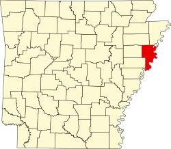
Cunningham Corner
Cunningham Corner's position in Arkansas.
Coordinates: 35°11′30″N90°17′30″W / 35.19167°N 90.29167°W / 35.19167; -90.29167
Country United States
State Arkansas
County Crittenden
Township Jackson
Elevation
[1]
217 ft (66 m)
Time zone UTC-6 (Central (CST))
  Summer (DST) UTC-5 (CDT)
Area code 870
GNIS feature ID67798 [1]

Cunningham Corner (formerly Cunningham's Corner) is an unincorporated community in Jackson Township, Crittenden County, Arkansas, United States. [1] It is located at the intersection of Highway 147 and Highway 128 approximately six miles west-northwest of West Memphis. [2]

Related Research Articles

<span class="mw-page-title-main">White County, Arkansas</span> County in Arkansas, United States

White County is a county located in the U.S. state of Arkansas. As of the 2020 census, the population was 76,822. The county seat is Searcy. White County is Arkansas's 31st county, formed on October 23, 1835, from portions of Independence, Jackson, and Pulaski counties and named for Hugh Lawson White, a Whig candidate for President of the United States. It is an alcohol prohibition or dry county, though a few private establishments can serve alcohol.

<span class="mw-page-title-main">U.S. Route 49</span> Highway in the United States

U.S. Route 49 is a north–south United States highway. The highway's northern terminus is in Piggott, Arkansas, at an intersection with US Route 62/Highway 1/Highway 139 (US 62/AR 1/AR 139). Its southern terminus is in Gulfport, Mississippi, at an intersection with U.S. Route 90. US 49 is approximately 516 miles (830 km) in length.

<span class="mw-page-title-main">U.S. Route 412</span> Highway in the United States

U.S. Route 412 is an east–west United States highway, first commissioned in 1982. U.S. 412 overlaps expressway-grade Cimarron Turnpike from Tulsa west to Interstate 35 and the Cherokee Turnpike from 5 miles (8.0 km) east of Chouteau, Oklahoma, to 8 miles (13 km) west of the Arkansas state line. It runs the entire length of the Oklahoma Panhandle and traverses the Missouri Bootheel. Despite its numbering it is not associated with U.S. Route 12.

<span class="mw-page-title-main">U.S. Route 67</span> Highway in the United States

U.S. Route 67 is a major north–south U.S. highway which extends for 1,560 miles (2,511 km) in the Central United States. The southern terminus of the route is at the United States-Mexico border in Presidio, Texas, where it continues south as Mexican Federal Highway 16 upon crossing the Rio Grande. The northern terminus is at U.S. Route 52 in Sabula, Iowa. US 67 crosses the Mississippi River twice along its routing. The first crossing is at West Alton, Missouri, where US 67 uses the Clark Bridge to reach Alton, Illinois. About 240 miles (390 km) to the north, US 67 crosses the river again at the Rock Island Centennial Bridge between Rock Island, Illinois, and Davenport, Iowa. Additionally, the route crosses the Missouri River via the Lewis Bridge a few miles southwest of the Clark Bridge.

<span class="mw-page-title-main">U.S. Route 165</span> Highway in the United States

U.S. Route 165 is a north–south United States highway spur of U.S. Highway 65. It currently runs for 412 miles (663 km) from U.S. Route 90 in Iowa, Louisiana north to U.S. Highway 70 in North Little Rock, Arkansas. The route passes through the states of Arkansas and Louisiana. It passes through the cities of Monroe and Alexandria in Louisiana. A segment of US 165 serves as a routing of the Great River Road within Arkansas.

<span class="mw-page-title-main">Missouri Route 43</span> State highway in Missouri

Route 43 is a highway in western Missouri. Its northern terminus is at U.S. Route 54 midway between Nevada and Deerfield. Its southern terminus is at the corner of Missouri, Arkansas, and Oklahoma where it continues down the Arkansas/Oklahoma state line as both Arkansas Highway 43 and Oklahoma State Highway 20.

<span class="mw-page-title-main">Arkansas Highway 102</span>

Highway 102 is an east–west state highway in Benton County, Arkansas. The highway connects two of western Benton County's population centers to Bentonville and Interstate 49 (I-49), the main north–south route in the Northwest Arkansas region.

The Loop is a 21.4-mile-long (34.4 km) beltway around Texarkana, TX and Texarkana, AR, which are twin cities in the U.S. states of Arkansas and Texas. Consisting of a section of Interstate 49 (I-49) in Arkansas, and Loop 151 and a section of I-369 and U.S. Route 59 (US 59) in Texas, it forms a three-quarter loop around the east, south and west sides of the city. The Loop is built to Interstate Highway standards.

<span class="mw-page-title-main">Arkansas Highway 89</span>

Highway 89 is a highway in the central part of the U.S. state of Arkansas.

<span class="mw-page-title-main">Arkansas Highway 77</span>

Highway 77 is a north–south state highway in Northeast Arkansas. The route of 66.70 miles (107.34 km) runs from US Highway 70 (US 70) in West Memphis north through small towns and agricultural areas of the Arkansas Delta to the Missouri state line. It is generally a low-traffic road except in West Memphis. Created during the 1926 Arkansas state highway numbering, the route was extended in the 1950s and 1960s, including along a former alignment of US 61. AR 77 does not have any spur or business routes.

<span class="mw-page-title-main">Arkansas Highway 121</span>

Arkansas Highway 121 is a designation for two state highways in Lee County, Arkansas. One route of 9.49 miles (15.27 km) runs from the St. Francis River to US Route 79 (US 79) northeast of Marianna. A second routing begins north of Marianna at Highway 1 and runs essentially in a half-loop counterclockwise to LaGrange.

<span class="mw-page-title-main">Arkansas Highway 1</span> State highway in Arkansas, United States

Highway 1 is a north–south state highway in east Arkansas. The route of 159.88 miles (257.30 km) runs from US Route 278 (US 278) in McGehee north to Supplemental Route BB at the Missouri state line. One of the original 1926 state highways, Highway 1 has remained very close to its original routing. The highway contains an overlap of approximately 50 miles (80 km) with U.S. Route 49.

<span class="mw-page-title-main">Arkansas Highway 11</span> United States historic place

Arkansas Highway 11 is a designation for three state highways in Arkansas. One segment of 36.23 miles (58.31 km) runs from US Route 63 (US 63) at Pansy to Huff Island Public Use Area near Grady. A second segment of 12.83 miles (20.65 km) begins just across the Arkansas River at the eastern terminus of Highway 88 at Reydell and runs north to US 65 west of De Witt. A third route of 37.53 miles (60.40 km) runs from Interstate 40 (I-40) and US 63 in Hazen north to Highway 367 in Searcy.

<span class="mw-page-title-main">Arkansas Highway 108</span>

Highway 108 is a state highway composed of two segments in the southwestern corner of the U.S. state of Arkansas. The northern segment begins as a continuation of State Highway 87 near the extreme southeastern corner of Oklahoma. The northern segment ends at U.S. Highway 59 and U.S. Highway 71 at Ashdown. The southern segment begins 13 miles (21 km) to the south along US 59 / US 71, at the Texas state line. The route ends at U.S. Highway 67 northeast of Texarkana.

<span class="mw-page-title-main">Arkansas Highway 35</span>

Arkansas Highway 35 is a northwest–southeast state highway in southeast Arkansas. The route runs 115.83 miles (186.41 km) from Dewey near the Mississippi River northwest to Arkansas Highway 5 in Benton.

<span class="mw-page-title-main">Arkansas Highway 218</span>

Arkansas Highway 218 is an east–west state highway in Crittenden County, Arkansas. The route of 7.35 miles (11.83 km) runs from US Route 70 (US 70) and US 79 at Shearerville north across Interstate 40 (I-40) through rural Crittenden County to Highway 147 at Cunningham Corner.

Midway Corner is an unincorporated community in Crittenden County, Arkansas, United States. Midway Corner is located on Arkansas Highway 147, 8.2 miles (13.2 km) southwest of West Memphis.

<span class="mw-page-title-main">Arkansas Highway 57</span>

Highway 57 is a north–south state highway in Southwest Arkansas. The route of 39.38 miles (63.38 km) begins at US Highway 82 (US 82) at Marysville and runs north to Highway 24 in Chidester. The route is maintained by the Arkansas State Highway and Transportation Department (AHTD).

<span class="mw-page-title-main">Arkansas Highway 318</span>

Highway 318 is a designation for two state highways in Phillips County, Arkansas. One route of 4.39 miles (7.07 km) begins at Highway 85 at Oneida and runs east to Highway 44. A second route of 15.12 miles (24.33 km) begins at Highway 1 and runs east to Highway 20. A portion of the route between Watkins Corner and Lambrook is designated as part of the Great River Road National Scenic Byway.

<span class="mw-page-title-main">Arkansas Highway 78</span>

Highway 78 is a designation for two state highways in the Arkansas Delta. One route of 24.03 miles (38.67 km) begins at Highway 306 near Hunter and runs southeast to US Highway 79 (US 79). A second route of 4.30 miles (6.92 km) begins at Highway 121 and runs west to a junction with Lee County Route 132 (CR 132) and CR 173. A short spur route in Moro, Highway 78 Spur connects the parent route to Highway 238. All routes are maintained by the Arkansas State Highway and Transportation Department (AHTD).

References

  1. 1 2 3 U.S. Geological Survey Geographic Names Information System: Cunningham Corner, Arkansas
  2. Arkansas Atlas and Gazetteer, DeLorme, 2nd ed., 2004, p. 45 ISBN   0899333451