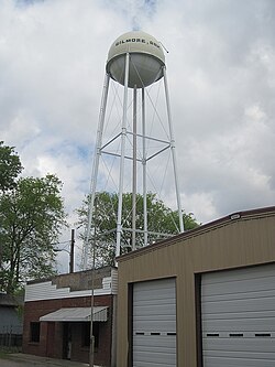
Gilmore, Arkansas

Last updated
Gilmore, Arkansas
Gilmore AR 002.jpg
Crittenden County Arkansas Incorporated and Unincorporated areas Gilmore Highlighted 0527040.svg
Location of Gilmore in Crittenden County, Arkansas.
Coordinates: 35°24′52″N90°16′40″W / 35.41444°N 90.27778°W / 35.41444; -90.27778
Country United States
State Arkansas
County Crittenden
Area
[1]
  Total13.54 sq mi (35.07 km2)
  Land13.52 sq mi (35.01 km2)
  Water0.03 sq mi (0.07 km2)
Elevation
[2]
220 ft (70 m)
Population
 (2020)
  Total176
  Density13.02/sq mi (5.03/km2)
Time zone UTC-6 (Central (CST))
  Summer (DST) UTC-5 (CDT)
ZIP code
72339
Area code 870
FIPS code 05-27040
GNIS feature ID2403698 [2]

Gilmore is a city in Crittenden County, Arkansas, United States. Per the 2020 census, the population was 176. [3]

Contents

Geography

Gilmore is located in northern Crittenden County and is bordered to the south by the city of Turrell. Interstate 555 (as well as U.S. Routes 61 and 63) pass through the west part of Gilmore, leading northwest 44 miles (71 km) to Jonesboro and south 20 miles (32 km) via Interstate 55 to West Memphis. According to the United States Census Bureau, Gilmore has a total area of 0.23 square miles (0.6 km2), all land. [4]

Ecologically, Gilmore is located within the Northern Backswamps ecoregion within the larger Mississippi Alluvial Plain. The Northern Backswamps are a network of low-lying overflow areas and floodplains historically dominated by bald cypress, water tupelo, overcup oak, water hickory, and Nuttall oak forest subject to year-round or seasonal inundation. [5] The Wapanocca National Wildlife Refuge, which preserves some of the year-round flooded bald cypress forest typical of this ecoregion prior to development for row agriculture lies southeast of Gilmore.

Demographics

Historical population
CensusPop.Note
1960 438
1970 4615.3%
1980 5039.1%
1990 331−34.2%
2000 292−11.8%
2010 188−35.6%
2020 176−6.4%
U.S. Decennial Census [6]
2010 [7] 2020 [8]

2020 census

Gilmore city, Arkansas – Racial and ethnic composition
Note: the U.S. census treats Hispanic/Latino as an ethnic category. This table excludes Latinos from the racial categories and assigns them to a separate category. Hispanics/Latinos may be of any race.
Race / Ethnicity (NH = Non-Hispanic)Pop 2010 [7] Pop 2020 [8] % 2010% 2020
White alone (NH)425122.34%28.98%
Black or African American alone (NH)14410276.60%57.95%
Native American or Alaska Native alone (NH)000.00%0.00%
Asian alone (NH)000.00%0.00%
Pacific Islander alone (NH)000.00%0.00%
Some Other Race alone (NH)000.00%0.00%
Mixed Race or Multi-Racial (NH)050.00%2.84%
Hispanic or Latino (any race)2181.06%10.23%
Total188176100.00%100.00%

2000 Census

As of the census [9] of 2000, there were 292 people, 100 households, and 78 families residing in the town. The population density was 512.5 people/km2 (1,327 people/sq mi). There were 114 housing units at an average density of 200.1 units/km2 (518 units/sq mi). The racial makeup of the town was 19.86% White, 79.11% Black or African American, 0.68% from other races, and 0.34% from two or more races.

There were 100 households, out of which 38.0% had children under the age of 18 living with them, 43.0% were married couples living together, 31.0% had a female householder with no husband present, and 22.0% were non-families. 22.0% of all households were made up of individuals, and 8.0% had someone living alone who was 65 years of age or older. The average household size was 2.92 and the average family size was 3.38.

In the town the population was spread out, with 35.3% under the age of 18, 9.9% from 18 to 24, 24.3% from 25 to 44, 19.9% from 45 to 64, and 10.6% who were 65 years of age or older. The median age was 30 years. For every 100 females, there were 105.6 males. For every 100 females age 18 and over, there were 83.5 males.

The median income for a household in the town was $20,625, and the median income for a family was $22,031. Males had a median income of $29,375 versus $18,000 for females. The per capita income for the town was $8,867. About 29.1% of families and 38.6% of the population were below the poverty line, including 52.2% of those under the age of eighteen and 44.8% of those 65 or over.

Education

Gilmore is in the Marion School District. [10] Its comprehensive high school is Marion High School.

Gilmore was formerly in the Turrell School District. [11] On July 1, 2010, [12] the former Turrell district consolidated with the Marion School District, thus closing the former Turrell High School. [13]

Related Research Articles

<span class="mw-page-title-main">Crittenden County, Arkansas</span> County in Arkansas, United States

Crittenden County is a county located in the U.S. state of Arkansas. As of the 2020 census, the population was 48,163. The county seat is Marion, and the largest city is West Memphis.

<span class="mw-page-title-main">McNeil, Arkansas</span> City in Arkansas, United States

McNeil is a town in Columbia County, Arkansas, United States. The population was 516 at the 2010 census, down from 662 in 2000. The community was named after William B. McNeil, founder of the College Hill Academy.

<span class="mw-page-title-main">Caraway, Arkansas</span> City in Arkansas, United States

Caraway is a city in Craighead County, Arkansas, United States. The population was 1,279 at the 2010 census. It is included in the Jonesboro, Arkansas Metropolitan Statistical Area.

<span class="mw-page-title-main">Anthonyville, Arkansas</span> Town in Arkansas, United States

Anthonyville is a town in Crittenden County, Arkansas, United States. The population was 161 at the 2010 census, down from 250 in 2000.

<span class="mw-page-title-main">Crawfordsville, Arkansas</span> Town in Arkansas, United States

Crawfordsville, historically Crawfordville, is a town in Crittenden County, Arkansas, United States. The population was 479 at the 2010 census.

<span class="mw-page-title-main">Earle, Arkansas</span> City in Arkansas, United States

Earle is a city in Crittenden County, Arkansas, United States. Per the 2020 census, the population was 1,831.

<span class="mw-page-title-main">Edmondson, Arkansas</span> Town in Arkansas, United States

Edmondson is a town in Crittenden County, Arkansas, United States. The population was 427 at the 2010 census.

<span class="mw-page-title-main">Horseshoe Lake, Arkansas</span> Town in Arkansas, United States

Horseshoe Lake is a town in Crittenden County, Arkansas, United States. The population was 264 at the 2020 census.

<span class="mw-page-title-main">Jennette, Arkansas</span> Town in Arkansas, United States

Jennette is a town in Crittenden and St. Francis counties, Arkansas, United States. The population was 118 at the 2020 census.

<span class="mw-page-title-main">Jericho, Arkansas</span> Town in Arkansas, United States

Jericho is a town in Crittenden County, Arkansas, United States. The population was 119 at the 2010 census, down from 184 in 2000.

<span class="mw-page-title-main">Marion, Arkansas</span> City in Arkansas, United States

Marion is a city in and the county seat of Crittenden County, Arkansas, United States. The population was 12,345 at the 2010 census, a 38.7% increase since 2000. The city is part of the Memphis metropolitan area. It is the second largest city in Crittenden County, behind West Memphis.

<span class="mw-page-title-main">Sunset, Arkansas</span> Town in Arkansas, United States

Sunset is a town in Crittenden County, Arkansas, United States. The population was 198 at the 2010 census.

<span class="mw-page-title-main">Turrell, Arkansas</span> City in Arkansas, United States

Turrell is a city in Crittenden County, Arkansas, United States. Per the 2020 census, the population was 517.

<span class="mw-page-title-main">Carthage, Arkansas</span> Town in Arkansas, United States

Carthage is a town in Dallas County, Arkansas, United States. The population was 343 at the 2010 census.

<span class="mw-page-title-main">Wilmar, Arkansas</span> City in Arkansas, United States

Wilmar is a city in Drew County, Arkansas, United States. The population was 511 at the 2010 census, down from 571 in 2000.

<span class="mw-page-title-main">Haynes, Arkansas</span> Town in Arkansas, United States

Haynes is a town in Lee County, Arkansas, United States. The population was 150 at the 2010 census, down from 214 at the 2000 census.

<span class="mw-page-title-main">St. Paul, Arkansas</span> Town in Arkansas, United States

St. Paul is a town in Madison County, Arkansas, United States. The population was 111 at the 2020 census. It is on the edge of the Northwest Arkansas region.

<span class="mw-page-title-main">Pyatt, Arkansas</span> Town in Arkansas, United States

Pyatt is a town in western Marion County, Arkansas, United States. The population was 181 at the 2020 census, down from 221 in 2010.

<span class="mw-page-title-main">Lake View, Arkansas</span> Place in Arkansas, United States

Lake View is a city in Phillips County, Arkansas, United States. The population was 443 at the 2010 census. Because there is also a Lakeview in Baxter County. The original settlement name was "Turkey Scratch" from the 1850s to the official declaration of the town's namesake was in the 1920s. When the town was re-established in 1937, Lake View became one of three communities in Arkansas to be reserved for black farm families by the Resettlement Administration. It is one of the few communities in the U.S. with an African-American percentage at over 90 percent of the populations.

<span class="mw-page-title-main">Strong, Arkansas</span> City in Arkansas, United States

Strong is a city in Union County, Arkansas, United States. The population was 558 at the 2010 census.

References

  1. "2020 U.S. Gazetteer Files". United States Census Bureau. Retrieved October 29, 2021.
  2. 1 2 U.S. Geological Survey Geographic Names Information System: Gilmore, Arkansas
  3. "Gilmore city, Arkansas". United States Census Bureau . Retrieved April 15, 2022.
  4. "Geographic Identifiers: 2010 Demographic Profile Data (G001): Gilmore city, Arkansas". U.S. Census Bureau, American Factfinder. Archived from the original on February 12, 2020. Retrieved June 20, 2014.
  5. PD-icon.svg This article incorporates public domain material from Woods, A.J., Foti, T.L., Chapman, S.S., Omernik, J.M.; et al. Ecoregions of Arkansas (PDF). United States Geological Survey.{{citation}}: CS1 maint: multiple names: authors list (link) (color poster with map, descriptive text, summary tables, and photographs).
  6. "Decennial Census of Population and Housing by Decades". US Census Bureau.
  7. 1 2 "P2 Hispanic or Latino, and Not Hispanic or Latino by Race – 2010: DEC Redistricting Data (PL 94-171) – Gilmore city, Arkansas". United States Census Bureau .
  8. 1 2 "P2 Hispanic or Latino, and Not Hispanic or Latino by Race – 2020: DEC Redistricting Data (PL 94-171) – Gilmore city, Arkansasa". United States Census Bureau .
  9. "U.S. Census website". United States Census Bureau . Retrieved 2008-01-31.
  10. "2020 CENSUS - SCHOOL DISTRICT REFERENCE MAP: Crittenden County, AR" (PDF). U.S. Census Bureau . Retrieved 2022-09-22.
  11. "SCHOOL DISTRICT REFERENCE MAP (2010 CENSUS): Crittenden County, AR" (PDF). U.S. Census Bureau . Retrieved 2022-09-22.
  12. "ConsolidationAnnex_from_1983.xls" (Archive). Arkansas Department of Education. Retrieved on October 13, 2017.
  13. Lesnick, Gavin (12 April 2010). "VIDEO: Turrell School District consolidated into Marion". Arkansas Democrat-Gazette . Retrieved 11 February 2013.