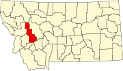
List of lakes in Powell County, Montana

Last updated
Map all coordinates using: OpenStreetMap  ·  Google Maps
Download coordinates as: KML  ·  GPX

There are at least 68 named lakes and reservoirs in Powell County, Montana .

Lake A body of relatively still water, in a basin surrounded by land

A lake is an area filled with water, localized in a basin, that is surrounded by land, apart from any river or other outlet that serves to feed or drain the lake. Lakes lie on land and are not part of the ocean, and therefore are distinct from lagoons, and are also larger and deeper than ponds, though there are no official or scientific definitions. Lakes can be contrasted with rivers or streams, which are usually flowing. Most lakes are fed and drained by rivers and streams.

Reservoir A storage space for fluids

A reservoir is, most commonly, an enlarged natural or artificial lake, pond or impoundment created using a dam or lock to store water.

Powell County, Montana County in the United States

Powell County is a county in the U.S. state of Montana. As of the 2010 United States Census, the population was 7,027. Its county seat is Deer Lodge.
Contents

Lakes

Powell Lake is a lake in the northern Sunshine Coast region of British Columbia, Canada, adjacent to the city of Powell River, which sits on the low rise of land forming a natural dam between the lake and the Strait of Georgia. The lake is fed by the Powell River and features Goat Island, a large mountainous island. It serves as a reservoir for a small hydroelectric generating station which was built to serve the city's paper mill, and also served as a water supply for that paper mill.

Reservoirs

Lois Lake lake in British Columbia, Canada

Lois Lake is a lake located on Vancouver Island, Canada, north of Great Central Lake, south of Elsie Lake.

Tin Cup Lake

Tin Cup Lake is an alpine lake in Custer County, Idaho, United States, located in the White Cloud Mountains in the Sawtooth National Recreation Area. No trails lead to lake but it can be accessed from Sawtooth National Forest trail 680.

See also

Notes

  1. "Bear Lake". Geographic Names Information System . United States Geological Survey.
  2. "Beaver Pond". Geographic Names Information System . United States Geological Survey.
  3. "Beaver Pond". Geographic Names Information System . United States Geological Survey.
  4. "Big Knife Lakes". Geographic Names Information System . United States Geological Survey.
  5. "Braziel Lake". Geographic Names Information System . United States Geological Survey.
  6. "Browns Lake". Geographic Names Information System . United States Geological Survey.
  7. "Caruthers Lake". Geographic Names Information System . United States Geological Survey.
  8. "Chimney Lakes". Geographic Names Information System . United States Geological Survey.
  9. "Coopers Lake". Geographic Names Information System . United States Geological Survey.
  10. "Crimson Lake". Geographic Names Information System . United States Geological Survey.
  11. "Deadmans Lake". Geographic Names Information System . United States Geological Survey.
  12. "Dolus Lakes". Geographic Names Information System . United States Geological Survey.
  13. "Doney Lake". Geographic Names Information System . United States Geological Survey.
  14. "Elbow Lake". Geographic Names Information System . United States Geological Survey.
  15. "Evans Lake". Geographic Names Information System . United States Geological Survey.
  16. "Hagan Pond". Geographic Names Information System . United States Geological Survey.
  17. "James Lake". Geographic Names Information System . United States Geological Survey.
  18. "Jones Lake". Geographic Names Information System . United States Geological Survey.
  19. "Kleinschmidt Lake". Geographic Names Information System . United States Geological Survey.
  20. "Lahrity Lake". Geographic Names Information System . United States Geological Survey.
  21. "Lake Otatsy". Geographic Names Information System . United States Geological Survey.
  22. "Lena Lake". Geographic Names Information System . United States Geological Survey.
  23. "Lilly Lake". Geographic Names Information System . United States Geological Survey.
  24. "Little Goat Lake". Geographic Names Information System . United States Geological Survey.
  25. "Moose Lake". Geographic Names Information System . United States Geological Survey.
  26. "Morrell Lake". Geographic Names Information System . United States Geological Survey.
  27. "Mud Lake". Geographic Names Information System . United States Geological Survey.
  28. "Nolo Lake". Geographic Names Information System . United States Geological Survey.
  29. "Otis Lake". Geographic Names Information System . United States Geological Survey.
  30. "Perkins Pond". Geographic Names Information System . United States Geological Survey.
  31. "Powell Lake". Geographic Names Information System . United States Geological Survey.
  32. "Prisoner Lake". Geographic Names Information System . United States Geological Survey.
  33. "Pyramid Lake". Geographic Names Information System . United States Geological Survey.
  34. "Reservoir Lake". Geographic Names Information System . United States Geological Survey.
  35. "Rice Lake". Geographic Names Information System . United States Geological Survey.
  36. "Ryan Lake". Geographic Names Information System . United States Geological Survey.
  37. "Shoup Lake". Geographic Names Information System . United States Geological Survey.
  38. "Slate Lake". Geographic Names Information System . United States Geological Survey.
  39. "Spawn Lake". Geographic Names Information System . United States Geological Survey.
  40. "Trask Lakes". Geographic Names Information System . United States Geological Survey.
  41. "Tupper Lake". Geographic Names Information System . United States Geological Survey.
  42. "Upper Elliot Lake". Geographic Names Information System . United States Geological Survey.
  43. "Upsata Lake". Geographic Names Information System . United States Geological Survey.
  44. "Bandy Reservoir". Geographic Names Information System . United States Geological Survey.
  45. "Bohn Lake". Geographic Names Information System . United States Geological Survey.
  46. "Bowman Lakes". Geographic Names Information System . United States Geological Survey.
  47. "Caruthers Lake". Geographic Names Information System . United States Geological Survey.
  48. "Conleys Lake". Geographic Names Information System . United States Geological Survey.
  49. "Doney Lake". Geographic Names Information System . United States Geological Survey.
  50. "Goat Lake". Geographic Names Information System . United States Geological Survey.
  51. "Kerns Lake". Geographic Names Information System . United States Geological Survey.
  52. "Lois Lake". Geographic Names Information System . United States Geological Survey.
  53. "Lower Bowman Lake". Geographic Names Information System . United States Geological Survey.
  54. "Lower Elliot Lake". Geographic Names Information System . United States Geological Survey.
  55. "Lower Taylor Reservoir". Geographic Names Information System . United States Geological Survey.
  56. "Lynn Reservoir". Geographic Names Information System . United States Geological Survey.
  57. "Martin Lake". Geographic Names Information System . United States Geological Survey.
  58. "Middle Bowman Lake". Geographic Names Information System . United States Geological Survey.
  59. "Miller Lake". Geographic Names Information System . United States Geological Survey.
  60. "Mountain Ben Lake". Geographic Names Information System . United States Geological Survey.
  61. "Mud Lake". Geographic Names Information System . United States Geological Survey.
  62. "Nevada Lake". Geographic Names Information System . United States Geological Survey.
  63. "Powell Reservoirs". Geographic Names Information System . United States Geological Survey.
  64. "Rock Creek Lake". Geographic Names Information System . United States Geological Survey.
  65. "Tin Cup Lake". Geographic Names Information System . United States Geological Survey.
  66. "Upper Bowman Lake". Geographic Names Information System . United States Geological Survey.
  67. "Upper Taylor Reservoir". Geographic Names Information System . United States Geological Survey.
  68. "Wales Creek Reservoir". Geographic Names Information System . United States Geological Survey.