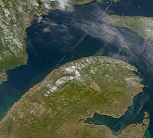
The Gaspé Peninsula, also known as Gaspesia, is a peninsula along the south shore of the Saint Lawrence River that extends from the Matapedia Valley in Quebec, Canada, into the Gulf of Saint Lawrence. It is separated from New Brunswick on its southern side by Chaleur Bay and the Restigouche River. The name Gaspé comes from the Miꞌkmaq word gespe'g, meaning "end", referring to the end of the land.

The Estrie is an administrative region of Quebec that replaced the Eastern Townships. Estrie, a French neologism, was coined as a derivative of est, "east". Originally settled by anglophones, today it is about 90 per cent francophone. Anglophones are concentrated in Lennoxville, home of the region's only English-speaking university, Bishop's University. The Eastern Townships School Board runs 20 elementary schools, three high schools, and a learning centre.

Antoine-Labelle is a regional county municipality located in the Laurentides region of Quebec, Canada. Its seat is Mont-Laurier. It is named for Antoine Labelle.

Mount Caubvick is a mountain located in Canada on the border between Labrador and Quebec in the Selamiut Range of the Torngat Mountains. It is the highest point in mainland Canada east of the Rockies. The mountain contains a massive peak that rises sharply from nearby sea level. Craggy ridges, steep cirques and glaciers are prominent features of the peak.

Mont-Saint-Hilaire is an off-island suburb of Montreal in southeastern Quebec, Canada, on the Richelieu River in the Regional County Municipality of La Vallée-du-Richelieu. The population as of the Canada 2011 Census was 18,200. The city is named after the Mont Saint-Hilaire.

Mont-Laurier is a town and incorporated municipality in northwest Quebec, Canada, located on the banks of the Lièvre River, a tributary of the Ottawa River. Known as the "Capital of the Haute-Laurentides", the motto of the town is Laurus elationis praemium, which translates to "Lift the laurels of reward". The demonym for its inhabitants is Lauriermontois.
The 2000–2006 municipal reorganization in Quebec resulted in large-scale amalgamation of smaller municipalities in Quebec into larger cities. It was undertaken by one administration, and modified and partially undone by its successor.

Autoroute 20 is a Quebec Autoroute, following the Saint Lawrence River through one of the more densely populated parts of Canada, with its central section forming the main route of the Trans-Canada Highway from the A-25 interchange to the A-85 interchange. At 585 km (363.5 mi), it is the longest Autoroute in Quebec. It is one of two main links between Montreal and Quebec City; the other is the A-40.

Autoroute 10 (A-10) is an Autoroute of Quebec in Canada that links greater Montreal to key population centres in Montérégie and Estrie, including Brossard, Saint-Jean-sur-Richelieu, Granby, and Sherbrooke.

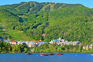
Mont-Tremblant is a city in the Laurentian Mountains of Quebec, Canada, approximately 130 kilometres (81 mi) northwest of Montreal and 140 kilometres (87 mi) northeast of Ottawa, Ontario. The current municipality with city status was formed in 2000. Mont-Tremblant is most famous for its ski resort, the Mont-Tremblant Ski Resort, which is seven kilometres from the village proper, at the foot of a mountain called Mont Tremblant.

Route 117, the Trans Canada Highway Northern Route, is a provincial highway within the Canadian province of Quebec, running between Montreal and the Quebec/Ontario border where it continues as Highway 66 east of McGarry, Ontario. It is an important road since it is the only direct route between southern Quebec and the Abitibi-Témiscamingue region.

Canadian Forces Station Mont Apica was a radar station of the Pinetree Line, located in Mont-Apica, Quebec, Canada, during the Cold War. The station opened as RCAF Station Mont Apica in 1952 and had a staff of some 500 persons at its peak.
Labelle is a provincial electoral district in the Laurentides region of Quebec, Canada that elects members to the National Assembly of Quebec. It notably includes the municipalities of Mont-Laurier, Mont-Tremblant, Rivière-Rouge, Mont-Blanc, Lac-des-Écorces and Labelle.
Gaspé is a provincial electoral district in the Gaspésie–Îles-de-la-Madeleine region of Quebec, Canada, which elects members to the National Assembly of Quebec. It is located on the eastern edge of the Gaspé Peninsula. It notably includes the municipalities of Gaspé, Sainte-Anne-des-Monts, Grande-Rivière and Percé.
An agglomeration, or urban agglomeration, is an administrative division of Quebec at the local level that may group together a number of municipalities which were abolished as independent entities on 1 January 2002 but reconstituted on 1 January 2006.

Sainte-Anne-des-Monts is a city in the Gaspésie–Îles-de-la-Madeleine region of the province of Quebec in Canada.

Mont-Mégantic National Park(Parc national du Mont-Mégantic) is a provincial park in Quebec, Canada. It is located near the municipality of Notre-Dame-des-Bois in the Estrie region. The park was created in 1994 and is adjacent to the Samuel-Brisson Ecological Reserve which is located northeast of it.

Mont-Orford National Park is a national park in Orford, Quebec, Canada that is maintained and protected by the Sépaq. a provincial body.

Club Soccer Mont-Royal Outremont is a Canadian semi-professional soccer club based in the Montreal boroughs of Mount Royal and Outremont. Since 2013, the club has competed in the Première ligue de soccer du Québec. Their women's team has competed in the women's division of the PLSQ since 2019.