WikiMili
List of lighthouses in Madeira
Last updated
October 08, 2025
Contents
Lighthouses
See also
References
External links
Map all coordinates using
OpenStreetMap
Download coordinates as
KML
This is a list of
lighthouses
in
Madeira
.
[
1
]
[
2
]
Lighthouses
Name
Image
Year
built
Location &
coordinates
Class of light
[
2
]
Focal
height
[
2
]
NGA
number
[
2
]
Admiralty
number
[
2
]
Range
nml
[
2
]
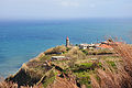
Câmara de Lobos Lighthouse
1937
Câmara de Lobos
32°38′49.2″N
16°58′32.1″W
/
32.647000°N 16.975583°W
/
32.647000; -16.975583
Oc R 6s.
23 metres (75
ft)
23724
D2744
9
Funchal Breakwater Lighthouse
n/a
Funchal
32°38′30.7″N
16°54′25.4″W
/
32.641861°N 16.907056°W
/
32.641861; -16.907056
Fl R 5s.
15 metres (49
ft)
23728
D2738
8
Ilhéu de Bugio Lighthouse
2003
Deserta Grande Island
32°24′15.6″N
16°27′49.0″W
/
32.404333°N 16.463611°W
/
32.404333; -16.463611
Fl W 4s.
72 metres (236
ft)
23752
D2722
13
Ilhéu do Chão Lighthouse
1959
Deserta Grande Island
32°35′22.7″N
16°32′45.2″W
/
32.589639°N 16.545889°W
/
32.589639; -16.545889
L Fl (2) W 15s.
112 metres (367
ft)
23748
D2720
13
Ilhéu de Cima Lighthouse
1900
Porto Santo Island
33°03′17.1″N
16°16′43.3″W
/
33.054750°N 16.278694°W
/
33.054750; -16.278694
Fl (3) W 15s.
124 metres (407
ft)
23756
D2756
21
Ilhéu de Ferro Lighthouse
1959
Porto Santo Island
33°02′19.9″N
16°24′22.0″W
/
33.038861°N 16.406111°W
/
33.038861; -16.406111
L Fl W 15s.
130 metres (430
ft)
23768
D2762
13
Ilhéu Mole Lighthouse
n/a
Porto Moniz
32°52′10.8″N
17°09′50.7″W
/
32.869667°N 17.164083°W
/
32.869667; -17.164083
Fl WR 5s.
65 metres (213
ft)
23708
D2754
white: 10
red: 8
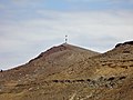
Ponta do Pargo Lighthouse
1922
Ponta do Pargo
32°48′50.1″N
17°15′47.0″W
/
32.813917°N 17.263056°W
/
32.813917; -17.263056
Fl (3) W 20s.
312 metres (1,024
ft)
23712
D2752
26
Ponta de São Jorge Lighthouse
1959
São Jorge
32°50′04.6″N
16°54′22.3″W
/
32.834611°N 16.906194°W
/
32.834611; -16.906194
L Fl W 5s.
271 metres (889
ft)
23744
D2755
15
Ponta de São Lourenço Lighthouse
1870
Madeira
32°43′47.7″N
16°39′25.1″W
/
32.729917°N 16.656972°W
/
32.729917; -16.656972
Fl W 5s.
103 metres (338
ft)
23740
D2726
20
Porto Santo North Mole Lighthouse
n/a
Porto Santo
33°03′34.6″N
16°18′54.5″W
/
33.059611°N 16.315139°W
/
33.059611; -16.315139
Fl R 4s.
13 metres (43
ft)
23765
D2757.2
7
Porto Santo South Mole Lighthouse
n/a
Porto Santo
33°03′29.2″N
16°18′51.9″W
/
33.058111°N 16.314417°W
/
33.058111; -16.314417
Fl G 4s.
17 metres (56
ft)
23766
D2757
6
Ribeira Brava Lighthouse
~1920s
Ribeira Brava
32°40′07.8″N
17°03′53.0″W
/
32.668833°N 17.064722°W
/
32.668833; -17.064722
Fl R 5s.
34 metres (112
ft)
23720
D2746
9
Selvagem Grande Lighthouse
1977
Selvagem Grande Island
30°08′43.6″N
15°52′16.1″W
/
30.145444°N 15.871139°W
/
30.145444; -15.871139
Fl W 4s.
163 metres (535
ft)
23776
D2768
13
See also
List of lighthouses in Portugal
References
↑
Rowlett, Russ.
"Lighthouses of Portugal: Madeira"
.
The Lighthouse Directory
.
University of North Carolina at Chapel Hill
. Retrieved
2016-09-21
.
1
2
3
4
5
6
List of Lights,
Pub. 113:
The West Coasts of Europe and Africa, the Mediterranean Sea, Black Sea and Azovskoye More (Sea of Azov)
(PDF)
.
List of Lights
.
United States National Geospatial-Intelligence Agency
. 2016.
Retrieved 21 September 2016
External links
Wikimedia Commons has media related to
Lighthouses in Madeira
.
Rowlett, Russ.
"The Lighthouse Directory"
.
University of North Carolina at Chapel Hill
.
Portals
:
Portugal
Engineering
Architecture
v
t
e
Lists of lighthouses in Africa
Sovereign states
entirely
in Africa
Algeria
Angola
Benin
Cameroon
Cape Verde
Democratic Republic of the Congo
Republic of the Congo
Djibouti
Egypt
Equatorial Guinea
Eritrea
Gabon
The Gambia
Ghana
Guinea
Guinea-Bissau
Ivory Coast (Côte d'Ivoire)
Kenya
Liberia
Libya
Madagascar
Mauritania
Mauritius
Morocco
Mozambique
Namibia
Nigeria
São Tomé and Príncipe
Senegal
Seychelles
Sierra Leone
Somalia
Somaliland
1
South Africa
Sudan
Tanzania
Togo
Tunisia
partly
in Africa
France
Mayotte
Réunion
Italy
Pantelleria
Pelagie Islands
Portugal
Maderia
Spain
Canary Islands
Ceuta
Melilla
Territories
and
dependencies
Saint Helena
Ascension
UK
Western Sahara
2
1
State with limited recognition
.
2
Unclear sovereignty
Africa
portal
This page is based on this
Wikipedia article
Text is available under the
CC BY-SA 4.0
license; additional terms may apply.
Images, videos and audio are available under their respective licenses.