WikiMili
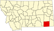
List of mountains in Powder River County, Montana
Last updated
March 22, 2022
Map all coordinates using:
OpenStreetMap
Download coordinates as:
KML
This list is
incomplete
; you can help by
adding missing items
.
(
February 2011
)
There are at least
65 named
mountains
in
Powder River County, Montana
.
Antelope Butte
,
45°40′01″N
105°02′19″W
/
45.66694°N 105.03861°W
/
45.66694; -105.03861
(
Antelope Butte
)
, el.
3,225 feet (983
m)
[1]
Bailey Hill
,
45°19′02″N
105°52′11″W
/
45.31722°N 105.86972°W
/
45.31722; -105.86972
(
Bailey Hill
)
, el.
4,206 feet (1,282
m)
[2]
Baldy Peak
,
45°12′36″N
105°31′33″W
/
45.21000°N 105.52583°W
/
45.21000; -105.52583
(
Baldy Peak
)
, el.
4,249 feet (1,295
m)
[3]
Bear Skull Mountain
,
45°08′18″N
105°26′40″W
/
45.13833°N 105.44444°W
/
45.13833; -105.44444
(
Bear Skull Mountain
)
, el.
4,258 feet (1,298
m)
[4]
Bell Tower
,
45°09′01″N
105°19′07″W
/
45.15028°N 105.31861°W
/
45.15028; -105.31861
(
Bell Tower
)
, el.
3,383 feet (1,031
m)
[5]
Black Eagle Butte
,
45°00′21″N
105°59′44″W
/
45.00583°N 105.99556°W
/
45.00583; -105.99556
(
Black Eagle Butte
)
, el.
4,088 feet (1,246
m)
[6]
Buffalo Butte
,
45°29′51″N
105°03′49″W
/
45.49750°N 105.06361°W
/
45.49750; -105.06361
(
Buffalo Butte
)
, el.
3,517 feet (1,072
m)
[7]
Castle Rock
,
45°17′06″N
105°24′50″W
/
45.28500°N 105.41389°W
/
45.28500; -105.41389
(
Castle Rock
)
, el.
3,474 feet (1,059
m)
[8]
Castle Rock
,
45°24′33″N
105°42′38″W
/
45.40917°N 105.71056°W
/
45.40917; -105.71056
(
Castle Rock
)
, el.
3,898 feet (1,188
m)
[9]
Castle Rock
,
45°45′42″N
105°53′35″W
/
45.76167°N 105.89306°W
/
45.76167; -105.89306
(
Castle Rock
)
, el.
3,458 feet (1,054
m)
[10]
Chico Buttes
,
45°05′24″N
106°10′27″W
/
45.09000°N 106.17417°W
/
45.09000; -106.17417
(
Chico Buttes
)
, el.
4,134 feet (1,260
m)
[11]
Cook Mountain
,
45°38′09″N
106°09′45″W
/
45.63583°N 106.16250°W
/
45.63583; -106.16250
(
Cook Mountain
)
, el.
4,206 feet (1,282
m)
[12]
Deer Creek Buttes
,
45°34′37″N
105°12′42″W
/
45.57694°N 105.21167°W
/
45.57694; -105.21167
(
Deer Creek Buttes
)
, el.
3,327 feet (1,014
m)
[13]
Deranleau Butte
,
45°21′03″N
105°06′20″W
/
45.35083°N 105.10556°W
/
45.35083; -105.10556
(
Deranleau Butte
)
, el.
3,606 feet (1,099
m)
[14]
Diamond Butte
,
45°14′57″N
105°55′59″W
/
45.24917°N 105.93306°W
/
45.24917; -105.93306
(
Diamond Butte
)
, el.
4,268 feet (1,301
m)
[15]
Dog Butte
,
45°18′14″N
105°25′05″W
/
45.30389°N 105.41806°W
/
45.30389; -105.41806
(
Dog Butte
)
, el.
3,501 feet (1,067
m)
[16]
Dry Creek Butte
,
45°16′06″N
105°12′20″W
/
45.26833°N 105.20556°W
/
45.26833; -105.20556
(
Dry Creek Butte
)
, el.
3,717 feet (1,133
m)
[17]
East Fork Buttes
,
45°21′33″N
105°11′56″W
/
45.35917°N 105.19889°W
/
45.35917; -105.19889
(
East Fork Buttes
)
, el.
3,671 feet (1,119
m)
[18]
Eldon Mountain
,
45°15′38″N
105°24′53″W
/
45.26056°N 105.41472°W
/
45.26056; -105.41472
(
Eldon Mountain
)
, el.
3,845 feet (1,172
m)
[19]
Fighting Butte
,
45°19′06″N
105°19′39″W
/
45.31833°N 105.32750°W
/
45.31833; -105.32750
(
Fighting Butte
)
, el.
3,278 feet (999
m)
[20]
Fivemile Hill
,
45°29′20″N
105°29′09″W
/
45.48889°N 105.48583°W
/
45.48889; -105.48583
(
Fivemile Hill
)
, el.
3,461 feet (1,055
m)
[21]
Gardner Butte
,
45°19′25″N
105°52′09″W
/
45.32361°N 105.86917°W
/
45.32361; -105.86917
(
Gardner Butte
)
, el.
4,285 feet (1,306
m)
[22]
Gobbler Knob
,
45°05′17″N
106°02′29″W
/
45.08806°N 106.04139°W
/
45.08806; -106.04139
(
Gobbler Knob
)
, el.
4,190 feet (1,280
m)
[23]
Goodspeed Butte
,
45°18′42″N
106°02′06″W
/
45.31167°N 106.03500°W
/
45.31167; -106.03500
(
Goodspeed Butte
)
, el.
3,963 feet (1,208
m)
[24]
Haystack Butte
,
45°30′10″N
105°41′38″W
/
45.50278°N 105.69389°W
/
45.50278; -105.69389
(
Haystack Butte
)
, el.
3,507 feet (1,069
m)
[25]
Home Creek Butte
,
45°36′08″N
105°56′13″W
/
45.60222°N 105.93694°W
/
45.60222; -105.93694
(
Home Creek Butte
)
, el.
4,409 feet (1,344
m)
[26]
Kelsey Hill
,
45°03′04″N
105°51′58″W
/
45.05111°N 105.86611°W
/
45.05111; -105.86611
(
Kelsey Hill
)
, el.
3,674 feet (1,120
m)
[27]
Lideen Hill
,
45°18′46″N
105°23′27″W
/
45.31278°N 105.39083°W
/
45.31278; -105.39083
(
Lideen Hill
)
, el.
3,520 feet (1,070
m)
[28]
Lightning Butte
,
45°23′46″N
105°02′51″W
/
45.39611°N 105.04750°W
/
45.39611; -105.04750
(
Lightning Butte
)
, el.
3,648 feet (1,112
m)
[29]
Liscom Butte
,
45°44′35″N
105°58′28″W
/
45.74306°N 105.97444°W
/
45.74306; -105.97444
(
Liscom Butte
)
, el.
4,344 feet (1,324
m)
[30]
Little Pilgrim Butte
,
45°29′40″N
105°11′13″W
/
45.49444°N 105.18694°W
/
45.49444; -105.18694
(
Little Pilgrim Butte
)
, el.
3,428 feet (1,045
m)
[31]
Lonesome Peak
,
45°16′37″N
105°30′48″W
/
45.27694°N 105.51333°W
/
45.27694; -105.51333
(
Lonesome Peak
)
, el.
3,632 feet (1,107
m)
[32]
Long Butte
,
45°03′11″N
106°07′04″W
/
45.05306°N 106.11778°W
/
45.05306; -106.11778
(
Long Butte
)
, el.
4,160 feet (1,270
m)
[33]
Mc Allister Butte
,
45°26′58″N
105°41′53″W
/
45.44944°N 105.69806°W
/
45.44944; -105.69806
(
Mc Allister Butte
)
, el.
3,707 feet (1,130
m)
[34]
Morellas Butte
,
45°20′03″N
105°03′11″W
/
45.33417°N 105.05306°W
/
45.33417; -105.05306
(
Morellas Butte
)
, el.
3,668 feet (1,118
m)
[35]
Mud Buttes
,
45°35′27″N
105°00′13″W
/
45.59083°N 105.00361°W
/
45.59083; -105.00361
(
Mud Buttes
)
, el.
3,402 feet (1,037
m)
[36]
Nipple Butte
,
45°04′02″N
106°09′41″W
/
45.06722°N 106.16139°W
/
45.06722; -106.16139
(
Nipple Butte
)
, el.
4,065 feet (1,239
m)
[37]
Oliphant Butte
,
45°39′44″N
105°08′24″W
/
45.66222°N 105.14000°W
/
45.66222; -105.14000
(
Oliphant Butte
)
, el.
3,235 feet (986
m)
[38]
Phillips Butte
,
45°16′04″N
105°58′35″W
/
45.26778°N 105.97639°W
/
45.26778; -105.97639
(
Phillips Butte
)
, el.
4,150 feet (1,260
m)
[39]
Pine Butte
,
45°23′54″N
105°00′27″W
/
45.39833°N 105.00750°W
/
45.39833; -105.00750
(
Pine Butte
)
, el.
3,510 feet (1,070
m)
[40]
Pine Hill
,
45°36′54″N
105°05′59″W
/
45.61500°N 105.09972°W
/
45.61500; -105.09972
(
Pine Hill
)
, el.
3,264 feet (995
m)
[41]
Preston Buttes
,
45°27′50″N
105°22′46″W
/
45.46389°N 105.37944°W
/
45.46389; -105.37944
(
Preston Buttes
)
, el.
3,241 feet (988
m)
[42]
Rattlesnake Butte
,
45°25′05″N
105°38′09″W
/
45.41806°N 105.63583°W
/
45.41806; -105.63583
(
Rattlesnake Butte
)
, el.
3,707 feet (1,130
m)
[43]
Rattlesnake Hill
,
45°46′54″N
105°18′14″W
/
45.78167°N 105.30389°W
/
45.78167; -105.30389
(
Rattlesnake Hill
)
, el.
3,409 feet (1,039
m)
[44]
Reanus Cone
,
45°11′37″N
106°06′36″W
/
45.19361°N 106.11000°W
/
45.19361; -106.11000
(
Reanus Cone
)
, el.
4,035 feet (1,230
m)
[45]
Red Butte
,
45°01′45″N
106°12′51″W
/
45.02917°N 106.21417°W
/
45.02917; -106.21417
(
Red Butte
)
, el.
4,242 feet (1,293
m)
[46]
Red Hill
,
45°37′55″N
105°03′41″W
/
45.63194°N 105.06139°W
/
45.63194; -105.06139
(
Red Hill
)
, el.
3,215 feet (980
m)
[47]
Red Top Hill
,
45°32′19″N
106°05′25″W
/
45.53861°N 106.09028°W
/
45.53861; -106.09028
(
Red Top Hill
)
, el.
3,609 feet (1,100
m)
[48]
Rocky Butte
,
45°10′39″N
105°20′16″W
/
45.17750°N 105.33778°W
/
45.17750; -105.33778
(
Rocky Butte
)
, el.
3,287 feet (1,002
m)
[49]
Sand Creek Hill
,
45°28′25″N
105°30′04″W
/
45.47361°N 105.50111°W
/
45.47361; -105.50111
(
Sand Creek Hill
)
, el.
3,501 feet (1,067
m)
[50]
Sandefer Butte
,
45°41′22″N
105°45′37″W
/
45.68944°N 105.76028°W
/
45.68944; -105.76028
(
Sandefer Butte
)
, el.
3,474 feet (1,059
m)
[51]
Shipley Butte
,
45°28′48″N
105°04′51″W
/
45.48000°N 105.08083°W
/
45.48000; -105.08083
(
Shipley Butte
)
, el.
3,300 feet (1,000
m)
[52]
Soldiers Mount
,
45°45′02″N
105°05′09″W
/
45.75056°N 105.08583°W
/
45.75056; -105.08583
(
Soldiers Mount
)
, el.
2,933 feet (894
m)
[53]
Stag Rock
,
45°19′16″N
106°09′28″W
/
45.32111°N 106.15778°W
/
45.32111; -106.15778
(
Stag Rock
)
, el.
3,432 feet (1,046
m)
[54]
Stag Rock Mountain
,
45°19′08″N
106°11′07″W
/
45.31889°N 106.18528°W
/
45.31889; -106.18528
(
Stag Rock Mountain
)
, el.
4,058 feet (1,237
m)
[55]
Taylor Butte
,
45°17′15″N
106°08′06″W
/
45.28750°N 106.13500°W
/
45.28750; -106.13500
(
Taylor Butte
)
, el.
3,989 feet (1,216
m)
[56]
Tepee Hill
,
45°41′58″N
105°13′09″W
/
45.69944°N 105.21917°W
/
45.69944; -105.21917
(
Tepee Hill
)
, el.
2,999 feet (914
m)
[57]
Terrett Butte
,
45°14′53″N
105°37′21″W
/
45.24806°N 105.62250°W
/
45.24806; -105.62250
(
Terrett Butte
)
, el.
3,530 feet (1,080
m)
[58]
Threemile Buttes
,
45°28′35″N
105°54′54″W
/
45.47639°N 105.91500°W
/
45.47639; -105.91500
(
Threemile Buttes
)
, el.
4,255 feet (1,297
m)
[59]
Twin Buttes,
45°42′43″N
105°35′10″W
/
45.71194°N 105.58611°W
/
45.71194; -105.58611
(
Twin Buttes
)
, el.
3,642 feet (1,110
m)
[60]
Twin Buttes,
45°35′36″N
105°27′32″W
/
45.59333°N 105.45889°W
/
45.59333; -105.45889
(
Twin Buttes
)
, el.
3,205 feet (977
m)
[61]
Two Tree Butte
,
45°30′16″N
105°43′17″W
/
45.50444°N 105.72139°W
/
45.50444; -105.72139
(
Two Tree Butte
)
, el.
3,776 feet (1,151
m)
[62]
Wallop Butte
,
45°05′34″N
106°05′38″W
/
45.09278°N 106.09389°W
/
45.09278; -106.09389
(
Wallop Butte
)
, el.
3,963 feet (1,208
m)
[63]
Yager Butte
,
45°27′35″N
106°01′29″W
/
45.45972°N 106.02472°W
/
45.45972; -106.02472
(
Yager Butte
)
, el.
4,016 feet (1,224
m)
[64]
Yarger Butte
,
45°17′00″N
105°40′03″W
/
45.28333°N 105.66750°W
/
45.28333; -105.66750
(
Yarger Butte
)
, el.
3,930 feet (1,200
m)
[65]
See also
List of mountains in Montana
List of mountain ranges in Montana
Notes
↑
"Antelope Butte"
.
Geographic Names Information System
.
United States Geological Survey
.
↑
"Bailey Hill"
.
Geographic Names Information System
.
United States Geological Survey
.
↑
"Baldy Peak"
.
Geographic Names Information System
.
United States Geological Survey
.
↑
"Bear Skull Mountain"
.
Geographic Names Information System
.
United States Geological Survey
.
↑
"Bell Tower"
.
Geographic Names Information System
.
United States Geological Survey
.
↑
"Black Eagle Butte"
.
Geographic Names Information System
.
United States Geological Survey
.
↑
"Buffalo Butte"
.
Geographic Names Information System
.
United States Geological Survey
.
↑
"Castle Rock"
.
Geographic Names Information System
.
United States Geological Survey
.
↑
"Castle Rock"
.
Geographic Names Information System
.
United States Geological Survey
.
↑
"Castle Rock"
.
Geographic Names Information System
.
United States Geological Survey
.
↑
"Chico Buttes"
.
Geographic Names Information System
.
United States Geological Survey
.
↑
"Cook Mountain"
.
Geographic Names Information System
.
United States Geological Survey
.
↑
"Deer Creek Buttes"
.
Geographic Names Information System
.
United States Geological Survey
.
↑
"Deranleau Butte"
.
Geographic Names Information System
.
United States Geological Survey
.
↑
"Diamond Butte"
.
Geographic Names Information System
.
United States Geological Survey
.
↑
"Dog Butte"
.
Geographic Names Information System
.
United States Geological Survey
.
↑
"Dry Creek Butte"
.
Geographic Names Information System
.
United States Geological Survey
.
↑
"East Fork Buttes"
.
Geographic Names Information System
.
United States Geological Survey
.
↑
"Eldon Mountain"
.
Geographic Names Information System
.
United States Geological Survey
.
↑
"Fighting Butte"
.
Geographic Names Information System
.
United States Geological Survey
.
↑
"Fivemile Hill"
.
Geographic Names Information System
.
United States Geological Survey
.
↑
"Gardner Butte"
.
Geographic Names Information System
.
United States Geological Survey
.
↑
"Gobbler Knob"
.
Geographic Names Information System
.
United States Geological Survey
.
↑
"Goodspeed Butte"
.
Geographic Names Information System
.
United States Geological Survey
.
↑
"Haystack Butte"
.
Geographic Names Information System
.
United States Geological Survey
.
↑
"Home Creek Butte"
.
Geographic Names Information System
.
United States Geological Survey
.
↑
"Kelsey Hill"
.
Geographic Names Information System
.
United States Geological Survey
.
↑
"Lideen Hill"
.
Geographic Names Information System
.
United States Geological Survey
.
↑
"Lightning Butte"
.
Geographic Names Information System
.
United States Geological Survey
.
↑
"Liscom Butte"
.
Geographic Names Information System
.
United States Geological Survey
.
↑
"Little Pilgrim Butte"
.
Geographic Names Information System
.
United States Geological Survey
.
↑
"Lonesome Peak"
.
Geographic Names Information System
.
United States Geological Survey
.
↑
"Long Butte"
.
Geographic Names Information System
.
United States Geological Survey
.
↑
"Mc Allister Butte"
.
Geographic Names Information System
.
United States Geological Survey
.
↑
"Morellas Butte"
.
Geographic Names Information System
.
United States Geological Survey
.
↑
"Mud Buttes"
.
Geographic Names Information System
.
United States Geological Survey
.
↑
"Nipple Butte"
.
Geographic Names Information System
.
United States Geological Survey
.
↑
"Oliphant Butte"
.
Geographic Names Information System
.
United States Geological Survey
.
↑
"Phillips Butte"
.
Geographic Names Information System
.
United States Geological Survey
.
↑
"Pine Butte"
.
Geographic Names Information System
.
United States Geological Survey
.
↑
"Pine Hill"
.
Geographic Names Information System
.
United States Geological Survey
.
↑
"Preston Buttes"
.
Geographic Names Information System
.
United States Geological Survey
.
↑
"Rattlesnake Butte"
.
Geographic Names Information System
.
United States Geological Survey
.
↑
"Rattlesnake Hill"
.
Geographic Names Information System
.
United States Geological Survey
.
↑
"Reanus Cone"
.
Geographic Names Information System
.
United States Geological Survey
.
↑
"Red Butte"
.
Geographic Names Information System
.
United States Geological Survey
.
↑
"Red Hill"
.
Geographic Names Information System
.
United States Geological Survey
.
↑
"Red Top Hill"
.
Geographic Names Information System
.
United States Geological Survey
.
↑
"Rocky Butte"
.
Geographic Names Information System
.
United States Geological Survey
.
↑
"Sand Creek Hill"
.
Geographic Names Information System
.
United States Geological Survey
.
↑
"Sandefer Butte"
.
Geographic Names Information System
.
United States Geological Survey
.
↑
"Shipley Butte"
.
Geographic Names Information System
.
United States Geological Survey
.
↑
"Soldiers Mount"
.
Geographic Names Information System
.
United States Geological Survey
.
↑
"Stag Rock"
.
Geographic Names Information System
.
United States Geological Survey
.
↑
"Stag Rock Mountain"
.
Geographic Names Information System
.
United States Geological Survey
.
↑
"Taylor Butte"
.
Geographic Names Information System
.
United States Geological Survey
.
↑
"Tepee Hill"
.
Geographic Names Information System
.
United States Geological Survey
.
↑
"Terrett Butte"
.
Geographic Names Information System
.
United States Geological Survey
.
↑
"Threemile Buttes"
.
Geographic Names Information System
.
United States Geological Survey
.
↑
"Twin Buttes"
.
Geographic Names Information System
.
United States Geological Survey
.
↑
"Twin Buttes"
.
Geographic Names Information System
.
United States Geological Survey
.
↑
"Two Tree Butte"
.
Geographic Names Information System
.
United States Geological Survey
.
↑
"Wallop Butte"
.
Geographic Names Information System
.
United States Geological Survey
.
↑
"Yager Butte"
.
Geographic Names Information System
.
United States Geological Survey
.
↑
"Yarger Butte"
.
Geographic Names Information System
.
United States Geological Survey
.
v
t
e
Municipalities and communities of
Powder River County, Montana
,
United States
County seat
:
Broadus
Town
Broadus
Powder River County map
CDP
Biddle
Other
communities
Belle Creek
Coalwood
Epsie
Moorhead
Olive
Otter
Powderville
Sonnette
Montana portal
United States portal
This page is based on this
Wikipedia article
Text is available under the
CC BY-SA 4.0
license; additional terms may apply.
Images, videos and audio are available under their respective licenses.