Haystack Butte

Last updated

Haystack Butte
Cloudy Haystack Butte.jpg
Northeast aspect
Highest point
Elevation 7,486 ft (2,282 m) [1]
Prominence 446 ft (136 m) [1]
Parent peak Mount Gould (9,557 ft) [2]
Isolation 1.06 mi (1.71 km) [2]
Coordinates 48°43′58″N113°43′58″W / 48.7326991°N 113.7327429°W / 48.7326991; -113.7327429 [3]
Geography
USA Montana relief location map.jpg
Red triangle with thick white border.svg
Haystack Butte
Location in Montana
Usa edcp relief location map.png
Red triangle with thick white border.svg
Haystack Butte
Location in the United States
Location Glacier National Park
Flathead County
Montana, U.S.
Parent range Lewis Range
Topo map USGS Logan Pass
Geology
Rock type Sedimentary rock
Climbing
Easiest route class 2 hiking

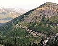
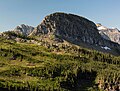
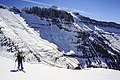
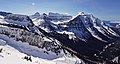
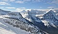
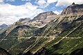
Haystack Butte is a 7,486-foot-elevation (2,282-meter) summit located in the Lewis Range, of Glacier National Park in the U.S. state of Montana. It is situated one mile west of the Continental Divide, in Flathead County, above the Weeping Wall on its south slope. Topographic relief is significant as the west aspect rises 3,900 feet (1,200 meters) above McDonald Creek in less than 1.5 mile. It can be seen from Logan Pass, and from Going-to-the-Sun Road which traverses the west and south slopes of the peak. The nearest higher neighbor is Mount Gould, 1.07 miles (1.72 km) to the northeast. [1] Climbing access is via the Highline Trail. This geographical feature's descriptive name was on maps as early as 1904, and was officially adopted March 6, 1929, by the United States Board on Geographic Names [3]

Contents

Climate

Based on the Köppen climate classification, Haystack Butte is located in an alpine subarctic climate zone with long, cold, snowy winters, and cool to warm summers. [4] Temperatures can drop below −10 °F with wind chill factors below −30 °F. Precipitation runoff from the peak drains into McDonald Creek, thence Lake McDonald.

Geology

Like other mountains in Glacier National Park, Haystack Butte Tail is composed of sedimentary rock laid down during the Precambrian to Jurassic periods. Formed in shallow seas, this sedimentary rock was initially uplifted beginning 170 million years ago when the Lewis Overthrust fault pushed an enormous slab of precambrian rocks 3 mi (4.8 km) thick, 50 miles (80 km) wide and 160 miles (260 km) long over younger rock of the cretaceous period. [5] The bulk of the peak is composed of limestone of the Siyeh Formation, with a diorite cap. [6]

See also

References

  1. 1 2 3 "Haystack Butte, Montana". Peakbagger.com. Retrieved August 19, 2021.
  2. 1 2 "Haystack Butte - 7,486' MT". listsofjohn.com. Retrieved August 19, 2021.
  3. 1 2 "Haystack Butte". Geographic Names Information System . United States Geological Survey, United States Department of the Interior . Retrieved August 19, 2021.
  4. Peel, M.C.; Finlayson, B.L. & McMahon, T.A. (2007). "Updated world map of the Köppen-Geiger climate classification" (PDF). Hydrology and Earth System Sciences . 11 (5): 1633–1644. Bibcode:2007HESS...11.1633P. doi: 10.5194/hess-11-1633-2007 . Archived (PDF) from the original on December 2, 2019. Retrieved November 7, 2025.
  5. Gadd, Ben (2008), Geology of the Rocky Mountains and Columbias
  6. James L. Dyson, The Geologic Story of Glacier National Park