List of neighbourhoods in Bangkok

Last updated
Baiyoke Tower 2 at Pratu Nam (second tallest building in Bangkok) Bangkok Baiyoke Tower.jpg
Baiyoke Tower 2 at Pratu Nam (second tallest building in Bangkok)

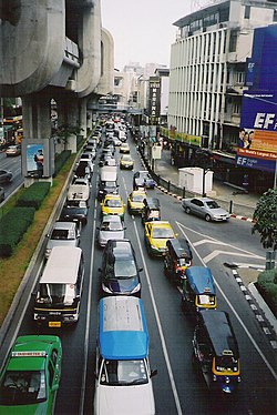
This is a partial list of neighbourhoods in Bangkok.

Contents

Bang Kapi

Bang Sue

Chatuchak

Traffic jam at Siam Square Bangkok-sukhumvit-road-traffic-200503.jpg
Traffic jam at Siam Square

Don Mueang

Dusit

Pathum Wan (well known as Ratchaprasong shopping street area)

Lights in front of Amarin Plaza at Ratchaprasong New Year Ratchaprasong.jpg
Lights in front of Amarin Plaza at Ratchaprasong

Phetchaburi

The Wat Phra Kaew temple at Sanam Luang Wat Phra Kaew outside view.jpg
The Wat Phra Kaew temple at Sanam Luang

Phra Nakhon (well known as Rattanakosin Island )

Khaosan Road at night Kaoh San Road.jpg
Khaosan Road at night
Under Saphan Phut at day Bangkok's Chinatown.jpg
Under Saphan Phut at day

Pom Prap Sattru Phai

Ratchadaphisek or Ratchada

Narathiwat Ratcha Nakharin Bangkok skytrain sunset.jpg
Narathiwat Ratcha Nakharin

Sathon

BTS Sala Daeng Station at Si Lom Bangkok Skytrain Saladaeng.jpg
BTS Sala Daeng Station at Si Lom

Si Lom

Inside Hua Lamphong (main railway station in Bangkok) Hualamphong St001.jpg
Inside Hua Lamphong (main railway station in Bangkok)

Sri Nakarin [1]

Sukhumvit

Wat Arun Wat Arun from Chao Phraya River.jpg
Wat Arun

Thon Buri

Thonburi railway station at Siriraj Thonburi railway station.jpg
Thonburi railway station at Siriraj
Phran Nok Thanon Pran Nok 2018.jpg
Phran Nok
Charan Sanit Wong near Faichai Thanon Charan Sanit awong 2019-2-23.jpg
Charan Sanit Wong near Faichai

Victory Monument

Victory Monument Victory Monument-Bangkok.jpg
Victory Monument

Wang Burapha

Yaowarat (Chinatown of Bangkok)

See also

Related Research Articles

<span class="mw-page-title-main">Phra Nakhon district</span> District of Bangkok

Phra Nakhon is one of the 50 districts (khet) of Bangkok, Thailand. It is the central district of Bangkok, including Rattanakosin Island. Neighboring districts are, from the north, clockwise: Dusit, Pom Prap Sattru Phai, Samphanthawong, and across the Chao Phraya River, Thon Buri, Bangkok Yai, Bangkok Noi, and Bang Phlat.

<span class="mw-page-title-main">Bangkok Yai district</span> Khet in Bangkok, Thailand

Bangkok Yai is one of the 50 districts (khet) of Bangkok, Thailand. Neighbouring districts are Bangkok Noi, Phra Nakhon, Thon Buri, Phasi Charoen, and Taling Chan.

<span class="mw-page-title-main">Prawet district</span> Khet in Bangkok, Thailand

Prawet is one of the 50 districts of Bangkok, Thailand. It is in the southeast. Neighboring districts are Bang Phli, Bang Na, Phra Khanong, Suan Luang, Bang Kapi, Saphan Sung and Lat Krabang (Bangkok).

<span class="mw-page-title-main">Phasi Charoen district</span> Khet in Bangkok, Thailand

Phasi Charoen is one of the 50 districts (Khet) of Bangkok, Thailand. The district is bounded by other Bangkok districts : Taling Chan, Bangkok Noi, Bangkok Yai, Thon Buri, Chom Thong, Bang Bon, and Bang Khae.

<span class="mw-page-title-main">Phra Khanong district</span> Khet in Bangkok, Thailand

Phra Khanong is one of the 50 districts (Khet) of Bangkok, Thailand. Its neighbor, clockwise from north, are Suan Luang, Prawet, and Bang Na districts of Bangkok, Phra Pradaeng district of Samut Prakan province, Khlong Toei and Watthana of Bangkok.

<span class="mw-page-title-main">Bang Khen district</span> Khet in Bangkok, Thailand

Bang Khen is one of the 50 districts (khet) of Bangkok, Thailand. It is bounded by other Bangkok districts : Sai Mai, Khlong Sam Wa, Khan Na Yao, Bueng Kum, Lat Phrao, Chatuchak, Lak Si, and Don Mueang.

<span class="mw-page-title-main">Bang Kapi district</span> Khet in Bangkok, Thailand

Bang Kapi is one of the 50 districts (khet) of Bangkok, Thailand. It is bounded by other Bangkok districts : Bueng Kum, Saphan Sung, Prawet, Suan Luang, Huai Khwang, Wang Thonglang, and Lat Phrao.

<span class="mw-page-title-main">Charoen Krung Road</span> Road in Bangkok

Charoen Krung Road is a major road in Bangkok and the first in Thailand to be built using modern construction methods. Built during 1862–1864 in the reign of King Mongkut, it runs from the old city centre in Rattanakosin Island, passes through Bangkok's Chinatown, continues into Bang Rak district, where it formerly served the community of European expatriates, and ends in Bang Kho Laem. Construction of the road marked a major change in Bangkok's urban development, with the major mode of transport shifting from water to land. Charoen Krung Road was Bangkok's main street up to the early 20th century, but later declined in prominence. It is still home to many historic buildings and neighbourhoods, which are beset by changes as extension of the underground MRT is poised to drive new development.

<span class="mw-page-title-main">National Stadium BTS station</span> Railway station in Bangkok, Thailand

National Stadium station is a BTS Skytrain station on the Silom Line in Pathum Wan District, Bangkok, Thailand.

<span class="mw-page-title-main">Outline of Bangkok</span> Overview of and topical guide to Bangkok

The following outline is provided as an overview of and topical guide to Bangkok:

<span class="mw-page-title-main">Atsadang Road</span>

Atsadang Road is a road in inner Bangkok overlaps four Subdistricts of Phra Nakhon District, Bowon Niwet, San Chaopho Suea, Wat Ratchabophit, and Wang Burapha Phirom. It's starting from Ratchadamnoen Avenue in the area beside Sanam Luang and Phan Phiphop Lila Bridge pass through to the end at the junction of Chakkraphet Road and Charoen Rat 31 Bridge in the area of Pak Khlong Talat behind Ban Mo neighbourhood near the Chao Phraya River. There's Khlong Khu Mueang Doem or Khlong Lot parallel along the length. The opposite is Rachini Road.

<span class="mw-page-title-main">Khlong Chak Phra subdistrict</span> Sub-district in Bangkok, Thailand

Khlong Chak Phra is one of the six khwaengs (sub-districts) of Taling Chan District in Bangkok's Thonburi side. It is the location of the district office.

<span class="mw-page-title-main">Pak Khlong Phasi Charoen</span> Khwaeng in Thailand

Pak Khlong Phasi Charoen is a khwaeng (sub-district) of Phasi Charoen District, Bangkok's Thonburi side.

<span class="mw-page-title-main">Bang Phrom subdistrict, Bangkok</span> Khwaeng in Thailand

Bang Phrom is a khwaeng (subdistrict) of Taling Chan district, Bangkok's Thonburi side.

<span class="mw-page-title-main">Rachini Road</span> Road in Bangkok, Thailand

Rachini Road is a road in inner Bangkok, located in Phra Borom Maha Ratchawang Subdistrict of Phra Nakhon District.

<span class="mw-page-title-main">Wat Tha Phra subdistrict</span> Khwaeng in Thailand

Wat Tha Phra is one of the two khwaeng (subdistrict) of Bangkok Yai District, Bangkok's Thonburi side.

<span class="mw-page-title-main">Banthat Thong Road</span> Road in Bangkok, Thailand

Banthat Thong Road is a street in Bangkok. It runs 2.2 kilometres (1.4 mi) from its junction with Rama IV Road at Saphan Lueang Intersection, through Pathum Wan and Ratchathewi districts, north to Phet Phra Ram Intersection, where it meets Phetchaburi Road. It crosses Rama I Road at Charoen Phon Intersection, near the National Stadium, and the area is home to a large number of sporting goods shops. The southern section of the road runs parallel to the canal Khlong Suan Luang, which also gives its name to the neighbourhood. The area's land is owned by Chulalongkorn University, whose Office of Property Management (PMCU) redeveloped most of the neighbourhood in the 2010s.

<span class="mw-page-title-main">On Nut Road</span>

On Nut Road is a soi (alley)-formed road in Bangkok. It is a separate section of Sukhumvit Road known as Soi Sukhumvit 77 and also the name of the same neighbourhood that it crosses over.

References