List of quadrant routes in Tioga County, Pennsylvania

Last updated

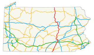
Quadrant Routes in Pennsylvania are maintained by the Pennsylvania Department of Transportation. This article lists all the routes and their termini in Tioga County. As is the case with the other counties in the state, the route numbers start in the northeast quadrant and go clockwise from the 1000s to the 4000s. Odd numbered roads travel south to north. Even numbered roads travel west to east. There is no explicit pattern for numbering order.

Pennsylvania State of the United States of America

Pennsylvania, officially the Commonwealth of Pennsylvania, is a state located in the northeastern, Great Lakes and Mid-Atlantic regions of the United States. The Appalachian Mountains run through its middle. The Commonwealth is bordered by Delaware to the southeast, Maryland to the south, West Virginia to the southwest, Ohio to the west, Lake Erie and the Canadian province of Ontario to the northwest, New York to the north, and New Jersey to the east.

The Pennsylvania Department of Transportation (PennDOT) oversees transportation issues in the Commonwealth of Pennsylvania. The administrator of PennDOT is the Pennsylvania Secretary of Transportation, currently Leslie Richards. Presently, PennDOT supports over 40,500 miles (65,200 km) of state roads and highways, about 25,000 bridges, as well as new roadway construction, the exception being the Pennsylvania Turnpike Commission, although they currently follow PennDOT policies and procedures. In addition, other modes of transportation are supervised or supported by PennDOT. These include aviation, rail traffic, mass transit, intrastate highway shipping traffic, motor vehicle safety & licensing, and driver licensing. PennDOT also supports the Ports of Philadelphia, Pittsburgh, and Erie. The current budget is approximately $3.8 billion in federal and state funds. The state budget is supported by the motor vehicle fuels tax which is dedicated solely to transportation issues.

Tioga County, Pennsylvania County in the United States

Tioga County is a county located on the central northern border of the U.S. state of Pennsylvania. As of the 2010 census, the population was 41,981. Its county seat is Wellsboro. The county was created on March 26, 1804, from part of Lycoming County and later organized in 1812. It is named for the Tioga River.

Contents

The north-south quadrant divider is US 6 east of Wellsboro and not explicitly delineated west of the borough. The east-west quadrant divider is an imaginary line through the middle of the county.

U.S. Route 6 in Pennsylvania section of U.S. Highway in Pennsylvania, United States

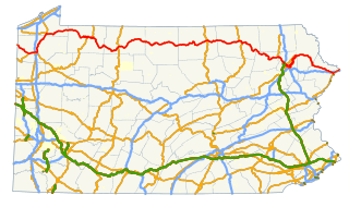
U.S. Route 6 (US 6) travels east–west near the north edge of the U.S. state of Pennsylvania from the Ohio state line near Pymatuning Reservoir east to the Mid-Delaware Bridge over the Delaware River into Port Jervis, New York. It is the longest highway segment in the Commonwealth. Most of it is a two-lane rural highway, with some freeway bypasses around larger towns. Except east of Dunmore, where it is paralleled by Interstate 84 (I-84), it is the main route in its corridor. What is now I-80—the Keystone Shortway—was once planned along the US 6 corridor as a western extension of I-84. The corridor was originally the Roosevelt Highway from Erie, Pennsylvania to Port Jervis, New York, designated Pennsylvania Route 7 in 1924. The PA 7 designation soon disappeared, but as US 6 was extended and relocated, the Roosevelt Highway followed it. The Pennsylvania section of US 6 was renamed the Grand Army of the Republic Highway in 1946; this name was applied to its full transcontinental length by 1953.

Wellsboro, Pennsylvania Borough in Pennsylvania, United States

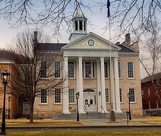
Wellsboro is a borough in Tioga County, Pennsylvania, United States, 52 miles (84 km) northwest of Williamsport. Early in the 20th century, Wellsboro was the shipping point and trade center for a large area. It had fruit evaporators, flour and woolen mills, a milk-condensing plant, marble works, saw mills, foundry and machine shops, and manufactories of cut glass, chemicals, rugs, bolts, cigars, carriages, and furniture. In 1900, 2,945 people lived here; in 1910, 3,183 lived here. The population was 3,328 at the 2000 census. It is the county seat of Tioga County, and also home to the Grand Canyon of Pennsylvania.

1000's

RouteLengthFromViaToNotes
1001 US 6 / PA 660 Grand Army of the Republic Highway in Charleston Township Whitneyville Road, Orebed Road, Lambs Creek Road US 6 Wellsboro Street in Mansfield 2 non-connecting segments, includes non-adjacent bridge on Lambs Creek Road over Lambs Creek
1002 BUS US 15 (QR 2005) Main Street, Elmira Street in Mansfield Elmira Street, Newtown Hill Road PA 549 in Sullivan Township
1003 BUS US 15 (QR 2005) Main Street in Mansfield Decker Street, Pickle Hill RoadQR 1004 Mill Creek Road in Painter Run
1004Dead end at Tioga Lake in Tioga Township Mill Creek RoadQR 1011 Bailey Creek Road, Mill Creek Road in Rutland Township Western terminus previously at old US 15 prior to Tioga-Hammond Reservoir
1005QR 1007 Elk Run Road at Tioga Lake in Sullivan Township Bungy Road, Elmira Street, Pumpkin Hill Road PA 549, QR 1011 Baily Creek Road in Jobs Corners 2 non-connecting segments, includes non-adjacent bridge on Bungy Road, northern terminus at the northern terminus of QR 1011
1006QR 1002 Elmira Street, Extension Street in Mansfield Coles Street US 6 Wellsboro Street in Mansfield
1007 US 6 Grand Army of the Republic Highway, Gray Road in Sullivan Township Elk Run Road, North Elk Run Road PA 549, Smith Road in Rutland Township
1008 PA 549 in Richmond Township Ashley Hill RoadAshley Hill Road at the Richmond-Sullivan township lineIncludes non-adjacent bridge on Ashley Hill Road over Elk Run
1010QR 1005 Bungy Road, Ashley Hill Road in Sullivan Township Austinville RoadQR 4016 (Bradford County) Austinville Road at the Bradford County line
1011 PA 549 in Rutland Township Bailey Creek Road PA 549, QR 1005 Pumpkin Hill Road in Jobs Corners Northern terminus at the northern terminus of QR 1005
1012 PA 549 in Rutland Township Sopertown RoadQR 4033 (Bradford County) Sopertown Road at the Bradford County line
1013QR 1011 Bailey Creek Road in Rutland Township Jackson Center Road PA 328 in Trowbridge Brief concurrency with QR 1018
1014 PA 549 in Rutland Township Hickory RoadQR 4036 (Bradford County) Hickory Road at the Bradford County line
1015QR 1028 Buckwheat Hollow Road in Lawrence Township unnamed road, State Street, Mechanic StreetOld US 15 at the New York state line Part of former alignment of US 15
1016 PA 549 in Jackson Township Hill Road, Baker RoadQR 4038 (Bradford County) Baker Road at the Bradford County line
1018 PA 328 in Jackson Township Warner Road, Pony Hill Road PA 549 in Jackson Township Brief concurrency with QR 1013
1020 PA 328 in Jackson Summit Alder Run Road PA 328 in Jackson Township
1022North Street at the New York state line North Road PA 328 in Millerton
1024 PA 287 in Tioga Township Mitchell Creek Road, Button Hill RoadButton Hill Road at the Jackson-Tioga township line
1026 PA 287, Collum Road in Somers Lane Woodford Road, Lawrence Road, Woodford RoadQR 1028 Buckwheat Hollow Road in Jackson Township
1028 PA 287 in Lawrence Township Buckwheat Hollow RoadState Line Road at the New York state line
1030Mann Hill Road, Oak Lane in Tioga Township Mann Hill Road, Cowanesque Street PA 287 Main Street, Cowanesque Street in Tioga
1032Bridge on Bear Creek Road over Crooked Creek in Tioga Township
1036QR 4037 Hills Creek Lake Road in Tioga Township Cobb RoadLake Road in Benedicts Corners
1038Park Hill Road overpass over US 15 in Tioga Township

2000's

RouteLengthFromViaToNotes
2001Bridge on Beuterstown Road over Blacks Creek in Liberty Township
2002QR 2003 Routes Road, Milk Plant Road in Liberty Township Milk Plant RoadQR 2005 Water Street in Liberty Includes non-adjacent bridge on Milk Plant Road over Blacks Creek in Liberty Township, Western terminus at the northern terminus of QR 2003
2003Route Road at the Lycoming County line Route RoadQR 2002 Milk Plant Road in Liberty Northern terminus as the western terminus of QR 2002
2004QR 1010 (Lycoming County) Roaring Branch Road at the Lycoming County line Route Road PA 14 in Union Township
2005QR 1009 (Lycoming County) Old US 15 at the Lycoming County line Blockhouse Road, Water Street, Bloss Mountain Road, North Williamson Road, Main Street, Old US 15 US 15 in Richmond Township Concurrencies with PA 660 and BUS US 15, brief concurrency with QR 2016
2006 PA 414 in Union Township Spencer RoadQR 3014 (Bradford County) at the Bradford County line
2007QR 1011 (Lycoming County) at the Lycoming County line Williamson Trail, Main Street PA 414 High Street / Water Street, QR 2005 Water Street in Liberty
2008 PA 414, Old Landon Road in Union Township West Union StreetWest Union Street at the Bradford County line
2009QR 2007 Main Street in Liberty Willow Street PA 414 in Liberty
2011QR 2005 Old US 15 in Liberty Township Alexander RoadBogar Run Road in Liberty Township
2012QR 2008, Porter Road in Union Township Alexander RoadWest Road at the Bradford County line
2013Forman Hollow Road at the Lycoming County line Farm Road PA 414 in Liberty Township
2014QR 2017 in Hamilton Township Morris Run Road, Main Street, River RoadRiver Road at the Hamilton-Ward township lineIncludes 3 non-adjacent bridges on River Road in Ward Township
2015 PA 14 in Roaring Branch unnamed road, Zoin Road, South Union Road PA 414 in Union Township Two non-adjacent segments
2016QR 2018 Cherry Flats Road in Charleston Township Arnot Road, Main Street, Arnot Road, Williamson RoadQR 2017 Main Street / Gulick Street in Blossburg Brief concurrency with QR 2005 (Old US 15)
2017 PA 14 in Roaring Branch Ogdensburg Road, Gulick Street, Main StreetQR 2005 Old US 15 in Blossburg Brief concurrency with QR 2005 (Old US 15)
2018 US 6 / PA 660 Grand Army of the Republic Highway in Charleston Township Cherry Flats RoadQR 2025 Canada Road in Covington Township
2019QR 2006 Spencer Road, Shanty Hollow Road in Union Township Randall Road PA 414 in Union Township
2020QR 2018 Cherry Flats Road in Cherry Flats Mack Road PA 660 in Covington Township
2021 PA 414, Back Road in Gleason Gleason RoadGleason Road at the Union-Ward township lineIncludes non-adjacent bridge on Gleason Road over the Tioga River in Ward Township
2022QR 2020 Cherry Flats Road in Covington Township Hill Road, State Street, East Hill Road, Old State RoadQR 3039 (Bradford County) Bailey Hill Road at the Bradford County line
2023QR 2005 Bloss Mountain Road in Liberty Township Lower Arnot Road, Church StreetQR 2016 Main Street, Church Street in Arnot
2024QR 2005 Old US 15 in Blossburg Ruah StreetRuah Street in Blossburg
2025QR 2005 Old US 15, Birdland Road in Covington Township Canada RoadQR 2022 State Street in Covington
2026Dead end at the Blossburg borough line unnamed roadQR 2005 Old US 15 in Blossburg Access road to US 15 (Blossburg exit)
2027QR 2022 East Hill Road in Covington Township Canoe Camp Creek RoadQR 2005 Old US 15 in Canoe Camp
2029QR 2022 Old State Road, Webster Road in Sullivan Township Mainesburg Road US 6 Grand Army of the Republic Highway, Seymour Hill Road in Mainesburg
2031QR 2022 Old State Road in Sullivan Township Old Mill Road US 6 Grand Army of the Republic Highway, T-513 in Mainesburg
2033QR 2022 Old State Road in Sullivan Township Gray Valley Road US 6 Grand Army of the Republic Highway in Sullivan Township

3000's

RouteLengthFromViaToNotes
3001QR 4009 (Lycoming County) Leetonia Road at the Lycoming County line Leetonia Road, Elk Run Road US 6 Grand Army of the Republic Highway, Barnhart Corners Road in Gaines Township 2 non-adjacent segments, includes 10 separate bridges between the two segments
3002QR 3001 Elk Run Road in Watrous Watrous Street US 6 Grand Army of the Republic Highway, Barnhart Corners Road in Gaines Township
3003 US 6 Grand Army of the Republic Highway, Barnhart Corners Road in Gaines Township Phoenix RoadQR 1005 (Potter County) Phoenix Road at the Potter County line
3004 PA 660 in Shippen Township Snyder Point Road PA 660 in Shippen Township unpaved
30053 non-adjacent bridges on Stony Fork Creek Road in Morris Township (1) and Delmar Township (2)
3006 PA 660, QR 3007 West Branch Road in Thumptown Stony Fork School RoadQR 3007 Stony Fork Road in Stony Fork Western terminus at the southern terminus of QR 3007
3007 PA 660, QR 3006 Stony Fork School Road in Thumptown West Branch Road, Dibble Hill Road, Stony Fork Road, Kelsey Street PA 660 West Avenue in Wellsboro Southern terminus at the western terminus of QR 3006
3008QR 3007 Stony Fork Road in Stony Fork Broughton Hollow Road PA 287 in Knapp
3009 PA 287 in Delmar Township Sand Run Road, Antrim Road, Round Top Hill Road US 6 / PA 660 Grand Army of the Republic Highway in Charleston Township
3010QR 3007 Stony Fork Road, Pheasant Hill Road in Delmar Township Balsam RoadQR 3019 Dean Hill Road in Delmar Township
3011QR 3009 Round Top Hill Road in Williard Shumway Road US 6 / PA 660 Grand Army of the Republic Highway in Pitts
3012QR 3009 Sand Run Road, Antrim Road in Antrim Main StreetMain Street, D Street in Antrim
3013QR 3014 Nauvoo Road in Morris Township Horn RoadPlank Road in Plank
3014 PA 287, T-315 in Morris Township Nauvoo Road PA 414 in Hartfield
3015QR 2016 Arnot, Shear Road in Charleston Township Welsh RoadQR 2018 Cherry Flats Road in Charleston Township
3016Linck Hill Road, Three Springs Run Road in Morris Township Linck Hill RoadQR 3014 Nauvoo Road in Nauvoo Includes 2 non-adjacent bridges on Three Springs Run Road in Morris Township
3019 PA 287 in Knapp Bradley Street, Pearl Street, Rectory Lane PA 660 Main Street, King Street in Wellsboro
3020QR 3007 Kelsey Street in Wellsboro Conway Street, Berwart Street PA 660 West Avenue in Wellsboro
3021Balsam Road at the Wellsboro borough line Greenwood Street PA 660 West Avenue in Wellsboro
30223 non-adjacent bridges on Lower Marsh Creek Road (2) and Straight Run Road (1) in Shippen Township
30236 non-adjacent bridges on Heise Run Road in Delmar Township
3024Bridge on Marsh Creek Road over Straight Run in Shippen Township
3029 PA 660 in Dexter Airport Road PA 362, Dantz Run Road in Delmar Township
30982 non-adjacent bridges on Knowltown Road in Delmar Township

4000's

RouteLengthFromViaToNotes
4001 PA 349 in Davis Wattles Run Road, Potter Brook Road PA 49 in Potter Brook 2 non-adjacent segments, includes 3 separate bridges on Potter Brook Road between the two non-adjacent segments in Clymer Township (2) and Westfield Township (1)
4002 US 6 / PA 287 Main Street / Tioga Street in Wellsboro Charleston Street, Charleston Road US 6 / PA 660 Grand Army of the Republic Highway in Charleston Township Brief concurrency with QR 4035
4003Bridge on Broughton Road over Broughton Brook in Westfield Township
4005 PA 49 Main Street / Tioga Street in Wellsboro North Fork Road, Brookfield Road CR 111 Brookfield Road at the New York state line
4006QR 1005 (Potter County) Phoenix Road at the Potter County lineunnamed roadQR 4001 Potter Brook Road in Westfield Township
4007 PA 49 in Westfield Township California Road, North Road PA 249 in Brookfield Township
4008QR 1016 (Potter County) North Fork Road at the Potter County lineunnamed roadQR 4005 in Brookfield Township
4009 PA 49 in Cowanesque Austinburg RoadQR 4005 in Brookfield Township CR 103 at the New York state line
4010Bridge on Jemason Road over Jemason Creek in Westfield Township
4011Blair Creek Road, Spencer Road in Chatham Township Blair Creek Road PA 249, Bates Hill Road in Little Marsh
4012 PA 349 in Sabinsville School Street, Beechwood Lake Road, Short Hill Road PA 249 in Chatham Township
40135 Bridges on Merrick Hill Road in Chatham Township (1) and Deerfield Township (4)
4014Norris Brook Road at the Chatham-Middlebury township lineNorris Brook Road PA 287, Cemetery Road in Niles Valley Includes 3 non-adjacent bridges on Norris Brook Road in Chatham Township
40152 Bridges on Lee Hill Road in Chatham Township
4016Bridge on Reese Hill Road over Catlin Hollow Creek in Charleston Township
4017 PA 249 in Keeneyville Locey Creek Road, Holden Street, Holden Brook Road CR 99 at the New York state line
4019QR 4017 Holden Street in Osceola Hammont Street, Camp Brook Road CR 127 at the New York state line
4020Bridge on Thornbottom Road over Thornbottom Creek in Nelson Township
4021State Road in Farmington Township Burfield Road, Tannery Hill Road, Buffalo Street PA 49 Main Street, Buffalo Street in Elkland
4022 PA 49 in Nelson Township Lakeview Drive, Bliss RoadBliss Road at the New York state line
4023 PA 49 Main Street in Elkland Ellison Road CR 55 at the New York state line
4024QR 4027 Cummings Creek Road, Starhigh Road in Farmington Township Elkhorn Road PA 287 in Tioga Township
4026Bridge on Gee Road in Farmington Township
4027 PA 249 in Middlebury Township Cummings Creek Road PA 49 in Nelson Township
4035QR 2018 Cherry Flats Road in Charleston Township Gas Company Road, Dartt Settlement Road, Catlin Hollow Road PA 287 in Middlebury Township Brief concurrency with QR 4002
4037QR 4002 Charleston Road in Charleston Township Hills Creek Road Lake RoadQR 4039 Hills Creek Road in Middlebury Township
4039QR 4037 Hills Creek Lake Road in Charleston Township Hills Creek Road PA 287 in Holliday
4041Bridge on Boatman Road over the Cowanesque River at the Knoxville borough line
40984 non-adjacent Bridges on Glenn Road in Chatham Township (3) and Deerfield Township (1)

See also

Related Research Articles

U.S. Route 15 highway in the United States

U.S. Route 15 is a 791.71 mi (1,274.13 km)-long United States highway, designated along South Carolina, North Carolina, Virginia, Maryland, Pennsylvania, and New York. The route is signed north–south, from U.S. Route 17 Alternate in Walterboro, South Carolina to Interstate 86 and NY 17 in Painted Post, New York.

U.S. Route 15 in Pennsylvania highway in Pennsylvania

U.S. Route 15 is a 791.71 mi -long United States highway, running from Walterboro, South Carolina to Painted Post, New York. In Pennsylvania, the highway runs for 194.89 miles, from the Maryland state line just south of Gettysburg, to the New York state line near Lawrenceville.

References