List of regions of Saxony

Last updated

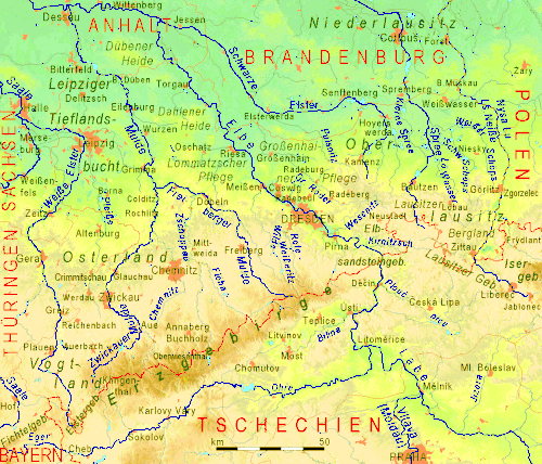
A classification of the various regions of Saxony cannot be achieved in any uniform or standard way, as the commonly used names usually represent a mixture of historical regions and geographical features. Many well-known names of regions, such as Lusatia, comprise a mixture of natural habitats and geological zones, while other, scientifically assigned, names are only known in university departments.

The following list contains, in alphabetical order, both those names that are commonly used, as well as those only known regionally or used in the scientific field. They are listed by their English names with their German names in brackets. Names of settlements or other geographic features are omitted here.

Overall, across much of the area, Saxony belongs both to Eastern Germany and Central Germany. However, on a smaller scale there are many regions and landscapes that overlap the boundaries of the Free State and extend beyond it:

Map of several important regions of Saxony and its neighbouring states and countries SachsenLandschaften.jpg
Map of several important regions of Saxony and its neighbouring states and countries
Topography of Saxony Sachsen2.gif
Topography of Saxony

See also

Related Research Articles

Lusatia Place

Lusatia is a region in Central Europe. The region is the home of the ethnic group of Sorbs, a small West Slavic people. It stretches from the Bóbr and Kwisa rivers in the east to the Pulsnitz and Black Elster in the west, today located within the German states of Saxony and Brandenburg as well as in the Lower Silesian and Lubusz voivodeships of western Poland.

Sächsische Schweiz (district) District in Saxony, Germany

The Sächsische Schweiz is a former district (Kreis) in the south of the Free State of Saxony, Germany. Neighboring districts were Weißeritzkreis, the district-free city Dresden and the districts Kamenz and Bautzen. To the south it borders the Czech Republic.

Radebeul–Radeburg railway railway line

The Radebeul–Radeburg railway, also known as the Lößnitzgrundbahn and locally nicknamed the Lößnitzdackel, is a 750 mm gauge narrow gauge steam-hauled railway in the outskirts of Dresden, Germany. It should not be confused with the Lößnitz Tramway, known in German as the Lößnitzbahn or the Lößnitzschaukel, which was a metre gauge interurban tramway that connected Dresden with Radebeul.

Roman Catholic Diocese of Dresden-Meissen diocese of the Catholic Church

The Diocese of Dresden-Meissen is a Diocese of Catholic Church in Germany with its seat in Dresden. It is suffragan to the Archdiocese of Berlin.

Dresden is a large city in the eastern German Free State of Saxony nearby the border to the Czech Republic at the river Elbe. The geography and urban development of Dresden is embossed by the valley location and by the Elbe stream.

Saxon Switzerland-Eastern Ore Mountains is a district (Kreis) in the Free State of Saxony, Germany. It is named after the mountain ranges Saxon Switzerland and Eastern Ore Mountains.

The Saxon Loess Fields refer to a natural region that lies mainly within the state of Saxony in central Germany. In addition, small areas of this region extend to the northwest and west into Saxony-Anhalt, to the southeast into Thuringia and to the northeast into Brandenburg. It more-or-less combines the BfN's major regions listed as D19 Saxon Upland and Ore Mountain Foreland, and D14, Upper Lusatia (Oberlausitz); only the range of Central Uplands hills, the Lusatian Mountains, has been excluded and instead forms part of the Saxon Highlands and Uplands.

Dresden Basin valley

The Dresden Basin is a roughly 45 km long and 10 km wide area of the Elbe Valley between the towns of Pirna and Meißen. The city of Dresden lies in the Dresden Basin.

Zittau Mountains mountain range

The Zittau Mountains, formerly also called the Lusatian Ridge, refer to the German part of the Lusatian Mountains that straddle the Saxon-Bohemian border in the extreme southeast of the German state of Saxony.

Dresden Heath forest in the city of Dresden, Germany

The Dresden Heath is a large forest in the city of Dresden. The heath is the most important recreation area in the city and is also actively forested. Approximately 6,133 hectares of the Dresden Heath are designated as a nature preserve, making it one of the largest municipal forests in Germany by area. Though mainly agricultural areas border the forest in the east, in all other directions the Dresden Heath is bordered by districts of the city and reaches nearly to the city centre in the southwest.

The Schönfeld Upland is a plateau in Dresden. It is named after Schönfeld, the district of Dresden in the middle of the plateau. Up to 1950, when Pillnitz was incorporated into Dresden, the upland was known as the Pillnitzer Elbe Plateau.

Werte der deutschen Heimat

Werte der deutschen Heimat originally Werte der Deutschen Heimat and, between 1970 and 1990 called Werte unserer Heimat, was a series of publications by former East German Academy of Sciences at Berlin, that was published by Akademie-Verlag Berlin and included more than 50 volumes. The work was undertaken by the Academy’s Local History Working Group within the Institute for Geography and Geo-ecology.

Eastern Ore Mountains

The Eastern Ore Mountains form a natural region of Saxony that covers the eastern part of the Saxon Ore Mountains range. Together with the Western and Central Ore Mountains, it is part of the larger Saxon Highlands and Uplands region. Its southern continuation beyond the German border covers an area of roughly the same extent in the Czech Republic.

The Central Saxon Hills, is a region of Hügelland with indistinct boundaries in the centre of the German state of Saxony.

Eastern Upper Lusatia is a natural region in Saxony and, in a broader sense, part of the Western Sudetes range including the Lower Silesian Voivodeship. The current Saxon division of natural regions view the region as part of the Saxon Loess Fields and divides it into 12 subdivisions at the level of meso-geochores.

West Lusatian Hill Country and Uplands

The West Lusatian Hill Country and Uplands, sometimes just the West Lusatian Hills, is a natural region in Saxony. It is divided into the West Lusatian Foothills in the east and the Lusatian Plateau in the west and forms the westernmost extremity of the Sudetes range.

The Königsbrück-Ruhland Heaths are a natural region in Saxony and in Brandenburg. They are located around the two towns that give the heathlands their name: Königsbrück and Ruhland, that, although in two different German states, are historically part of Upper Lusatia and represent border towns of that region. To the west is the Großenhainer Pflege, to the east the Upper Lusatian Heath and Pond Landscape. In the south they interleave with the West Lusatian Hill Country and Uplands.

Natural regions of Saxony

The classification of natural regions of Saxony shown here was produced between 1994 and 2001 by a working group called "Ecosystem and Regional Character" at the Saxonian Academy of Sciences in Leipzig as part of the research and development project "Natural Regions and Natural Region Potential of the Free State of Saxony" at a scale of 1:50,000 as the basis for the rural development and regional planning. This was also supported by the Saxon State Ministry of the Environment and Agriculture and the Saxon Ministry of the Interior.

Saxon-Lower Lusatian Heathland

The Saxon-Lower Lusatian Heathland is a natural region in the German state of Saxony. The current natural region division of the Free State of Saxony groups landscape units of the upper geochore or sub-regional level into three "Saxon natural regions" to produce a large-scale classification. These are part of higher order (cross-border) natural regions, whereas the landscape units previously used described areas that were largely confined within the borders of Saxony.