Dartmoor is an upland area in southern Devon, South West England. The moorland and surrounding land has been protected by National Park status since 1951. Dartmoor National Park covers 954 km2 (368 sq mi).
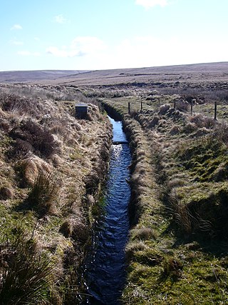
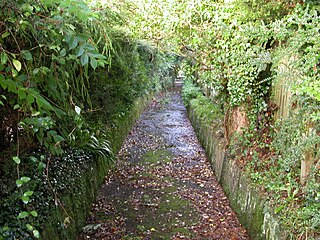
A leat is the name, common in the south and west of England and in Wales, for an artificial watercourse or aqueduct dug into the ground, especially one supplying water to a watermill or its mill pond. Other common uses for leats include delivery of water for hydraulic mining and mineral concentration, for irrigation, to serve a dye works or other industrial plant, and provision of drinking water to a farm or household or as a catchment cut-off to improve the yield of a reservoir.

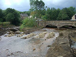
The Devonport Leat is a leat in Devon constructed in the 1790s to carry fresh drinking water from the high ground of Dartmoor to the expanding dockyards at Plymouth Dock.

The Elan Valley Reservoirs are a chain of man-made lakes created from damming the Elan and Claerwen rivers within the Elan Valley in Mid Wales. The reservoirs, which were built by the Birmingham Corporation Water Department, provide clean drinking water for Birmingham in the West Midlands of England. The five lakes are known as the Claerwen, Craig-goch, Pen-y-garreg, Garreg-ddu, and Caban-coch.
The River Loxley is a river in the City of Sheffield, South Yorkshire, England. Its source is a series of streams which rise some 10 miles (16 km) to the north-west of Sheffield on Bradfield Moors, flowing through Bradfield Dale to converge at Low Bradfield. It flows easterly through Damflask Reservoir and is joined by Storrs Brook at Storrs, near Stannington, and the River Rivelin at Malin Bridge, before flowing into the River Don at Owlerton, in Hillsborough. The Loxley valley provided the initial course of the Great Sheffield Flood, which happened after the Dale Dyke Dam collapsed shortly before its completion in March 1864.

The River Taff is a river in Wales. It rises as two rivers in the Brecon Beacons; the Taf Fechan and the Taf Fawr before becoming one just north of Merthyr Tydfil. Its confluence with the River Severn estuary is in Cardiff.
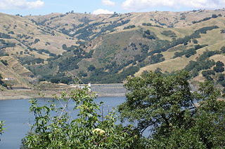
Calaveras Reservoir is located primarily in Santa Clara County, California, with a small portion and its dam in Alameda County, California. In Spanish, Calaveras means "skulls".
Drake's Leat, also known as Plymouth Leat, was a watercourse constructed in the late 16th century to tap the River Meavy on Dartmoor, England, from which it ran 17.5 miles (28.2 km) in order to supply Plymouth with water. It began at a point now under water at Burrator Reservoir, from which its path now emerges some 10m lower than the typical reservoir water level. It was one of the first municipal water supplies in the country.

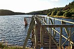
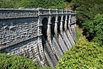
Burrator Reservoir is a reservoir situated on the southern side of Dartmoor in Devon, England. It is part of a number of reservoirs and dams that were built over the course of the 19th and 20th centuries in the area now covered by Dartmoor National Park to supply drinking water to the city of Plymouth and other rapidly growing towns in the surrounding lowlands.
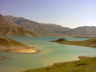
Lar Dam is a dam located at the foot of Mount Damavand in Amol county, Mazandaran, Iran. The dam is located within the protected Lar National Park, and situated just 70 kilometers northeast of the capital and the most populous city of the country, Iran. The primary purpose of the dam is municipal water supply to Tehran but prior to the water reaching the city filtration plant, it is used to power the Kalan and Lavarak Hydroelectric Power Stations, with a combined installed capacity of 162.5 MW.

Peasey Beck is a 19.6-kilometre-long (12.2 mi) beck flowing through Cumbria, England. It rises on Lambrigg Fell where it is known as the Sparishaw Beck, flows through Killington Reservoir and converges with Stainton Beck to form the River Bela at Milnthorpe. Prior to 1913, it was known as the River Beela throughout its length.
The River Meavy is a river in the southwest part of Dartmoor in Devon in south-west England. It runs entirely in the national park and connects Burrator Reservoir to the River Plym.

The Cann Quarry canal was a canal in Devon, England which ran for just under 2 miles (3.2 km) from Cann Quarry to the River Plym at Marsh Mills. It opened in 1829, and a short tramway connected it to the Plymouth and Dartmoor Railway at Crabtree Junction. It had been replaced by a tramway within ten years, but continued to be used as a mill leat to supply Marsh Mills corn mill, and most of it is still visible.

Pidcock's Canal was a canal in Gloucestershire, England, which connected ironworks at Upper Forge and Lower Forge, and also ran to an inlet from the River Severn called Lydney Pill. It was constructed from 1778 onwards, and there were three locks below Middle Forge. Following the construction of the Lydney Canal in 1813, the canal connected to that, rather than Lydney Pill, and it was disused after 1840, by which time a horse-drawn tramway had been built up the valley of The Lyd. The tramway was eventually relaid as a steam railway and is now preserved as the Dean Forest Railway. Most of the canal, colloquially called The Cut, still exists below Middle Forge.

The Sirindhorn Dam is in Sirindhorn District, Ubon Ratchatani, Thailand. It impounds the Lam Dom Noi River, and its reservoir is the province's largest water resource. The dam was commissioned in 1971 to serve as a hydropower facility as well as to supply irrigation water. The dam was named after Princess Royal Sirindhorn. All of the electricity generated by the dam is destined for domestic markets. The dam was constructed and is owned and operated by the Electricity Generating Authority of Thailand and is located in the Mekong River Basin, just upstream from the controversial Pak Mun Dam.

The Misicuni Multiplepurpose Project, better known as the Misicuni Dam, is a concrete-face rock-fill dam constructed on the Misicuni River about 35 km (22 mi) northwest of the city of Cochabamba, Bolivia. The dam will divert water from the Misicuni River to the Cochabamba Valley for several purposes to include providing water for irrigation and municipal water uses. In addition, the dam has an associated 120 MW hydroelectric power station, powered by 3 turbines 40 MW each. Construction on the dam began in June 2009 but was halted in November 2013 due to contract disputes. The company finished the construction and is started the operations in September 2017.

The Eller Beck is a small river in North Yorkshire, England, that flows through the town of Skipton and is a tributary of the River Aire. Its channel was heavily modified to supply water to mills in the 18th and 19th centuries, and although all the mills have closed, the water now supplies power to the National Grid, generated by a turbine at High Corn Mill. The beck flows through several underground culverts in Skipton that contribute to the flood risk. To alleviate flooding in Skipton town centre, a scheme involving two flood water storage reservoirs was designed and eventually completed in 2017.

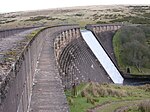
The Tottiford, Kennick, and Trenchford Reservoirs are three man-made, connected fresh water reservoirs near Hennock, Devon. They form three of the eight reservoirs built within the Dartmoor National Park, and were built to serve the water needs of Torquay, around 13 miles (21 km) away.