Related Research Articles

Maryland is a state in the Mid-Atlantic region of the United States. It borders Virginia to its south, West Virginia to its west, Pennsylvania to its north, Delaware and the Atlantic Ocean to its east, and the national capital of Washington, D.C. to the southwest. With a total area of 12,407 square miles (32,130 km2), Maryland is the ninth-smallest state by land area, and its population of 6,177,224 ranks it the 19th-most populous state and the fifth-most densely populated. Maryland's capital is Annapolis, and the most populous city is Baltimore.

Montgomery County is the most populous county in the U.S. state of Maryland. As of the 2020 census, the county's population was 1,062,061, increasing by 9.3% from 2010. The county seat is Rockville, and Germantown is the most populous place in the county. The county is adjoined to Washington, D.C., the nation's capital, and is part of the Washington metropolitan area and the Washington–Baltimore combined statistical area. Most of the county's residents live in Silver Spring, Bethesda, Germantown, and the incorporated cities of Rockville and Gaithersburg.
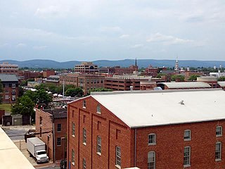
Frederick County is a county located in Maryland, United States. As of the 2020 U.S. census, the population was 271,717. The county seat is Frederick. The county is part of the Capital region of the state.

Prince George's County is located in the U.S. state of Maryland bordering the eastern portion of Washington, D.C. As of the 2020 U.S. census, the population was 967,201, making it the second-most populous county in Maryland, behind neighboring Montgomery County. The 2020 census counted an increase of nearly 104,000 in the previous ten years. Its county seat is Upper Marlboro. It is the most populous African American-majority county in the United States, as well as the second most affluent behind neighboring Charles County.
Baltimore County is the third-most populous county in the U.S. state of Maryland. The county is part of the Central Maryland region of the state. Baltimore County partly surrounds but does not include the independent city of Baltimore. It is part of the Northeast megalopolis, which stretches from Northern Virginia in the south to Boston in the north and includes major American population centers, including New York City and Philadelphia. Major economic sectors in the county include education, government, and health care. As of the 2020 census, the population was 854,535. The county is home to several universities, including Goucher College, Stevenson University, Towson University, and University of Maryland, Baltimore County.
Howard County is a county located in the U.S. state of Maryland. As of the 2020 census, the population was 334,529. Since there are no incorporated municipalities, there is no incorporated county seat either. Therefore, its county seat is the unincorporated community of Ellicott City. Howard County is part of the larger Washington–Baltimore combined statistical area. The county is part of the Central Maryland region of the state.

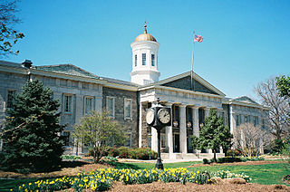
Anne Arundel County, also notated as AA or A.A. County, is located in the U.S. state of Maryland. As of the 2020 United States census, its population was 588,261, an increase of just under 10% since 2010. Its county seat is Annapolis, which is also the capital of the state. The county is named for Anne Arundell, Lady Baltimore, a member of the ancient family of Arundells in Cornwall, England, and the wife of Cecilius Calvert, 2nd Baron Baltimore (1605–1675), founder and first lord proprietor of the colony Province of Maryland. The county is part of the Central Maryland region of the state.

Cecil County is a county located in the U.S. state of Maryland at the northeastern corner of the state, bordering both Pennsylvania and Delaware. As of the 2020 census, the population was 103,725. The county seat is Elkton. The county is part of the Mid-Eastern Shore region of the state.

Carroll County is a county located in the U.S. state of Maryland. As of the 2020 census, the population was 172,891. Its county seat is Westminster. The county is part of the Central Maryland region of the state. Carroll County is included in the Washington-Baltimore-Arlington, DC-MD-VA-WV-PA Combined Statistical Area. While predominantly rural, the county has become increasingly suburban in recent years.

Queen Anne's County is a county located in the U.S. state of Maryland. As of the 2020 census, the population was 49,874. Its county seat and most populous municipality is Centreville. The census-designated place of Stevensville is the county's most populous place with a population of 7,442 as of 2020. The county is named for Queen Anne of Great Britain, who reigned when the county was established in 1706 during the colonial period. The county is part of the Mid-Eastern Shore region of the state.

Worcester County is the easternmost county of the U.S. state of Maryland. As of the 2020 census, the population was 52,460. Its county seat is Snow Hill. The county is part of the Lower Eastern Shore region of the state.

In the United States, a county or county equivalent is an administrative or political subdivision of a U.S. state or other territories of the United States which consists of a geographic area with specific boundaries and usually some level of governmental authority. The term "county" is used in 48 states, while Louisiana and Alaska have functionally equivalent subdivisions called parishes and boroughs, respectively. Counties and other local governments exist as a matter of U.S. state law, so the specific governmental powers of counties may vary widely between the states, with many providing some level of services to civil townships, municipalities, and unincorporated areas. Certain municipalities are in multiple counties; New York City is uniquely partitioned into five counties, referred to at the city government level as boroughs. Some municipalities have been consolidated with their county government to form consolidated city-counties, or have been legally separated from counties altogether to form independent cities. Conversely, counties in Connecticut and Rhode Island, eight of Massachusetts's 14 counties, and Alaska's Unorganized Borough have no government power, existing only as geographic distinctions.

Crofton is a census-designated place and planned community in Anne Arundel County, Maryland, United States, located 9.8 miles (15.8 km) west of the state capital Annapolis, 24 miles (39 km) south of Baltimore, and 24 miles (39 km) east-northeast of Washington, D.C. The community was established in 1964 and as of the 2020 census, it had a population of 29,136.

Bowie is a city in Prince George's County, Maryland, United States. Per the 2020 census, the population was 58,329. Bowie has grown from a small railroad stop to the largest municipality in Prince George's County, and the fifth most populous city and third largest city by area in the U.S. state of Maryland. In 2014, CNN Money ranked Bowie 28th in its Best Places to Live list.

Greenbelt is a city in Prince George's County, Maryland, United States, and a suburb of Washington, D.C. At the 2020 census, the population was 24,921.

The Washington metropolitan area, also referred to as the D.C. area, Greater Washington, the National Capital Region, or locally as the DMV, is the metropolitan area centered around Washington, D.C., the federal capital of the United States. The metropolitan area includes all of Washington, D.C. and parts of Maryland, Virginia, and West Virginia. It is part of the larger Washington–Baltimore combined statistical area, which is the third-largest combined statistical area in the country.

Baltimore City Public Schools (BCPS), also referred to as Baltimore City Public School System (BCPSS) or City Schools, is a public school district in the city of Baltimore, state of Maryland, United States. It serves the youth of Baltimore City. Traditionally, however, the Baltimore City Public Schools system has not referred to itself as a "district," as the operation of the schools was synonymous with the city of Baltimore. Its headquarters are located on 200 East North Avenue at North Calvert Street in the Dr. Alice G. Pinderhughes Administration Building.

Baltimore is the most populous city in the U.S. state of Maryland. With a population of 585,708 at the 2020 census, it is the 30th-most populous US city. Baltimore was designated as an independent city by the Constitution of Maryland in 1851, and is the most populous independent city in the nation. As of 2020, the population of the Baltimore metropolitan area was 2,838,327, the 20th-largest metropolitan area in the country. When combined the Washington–Baltimore combined statistical area (CSA) had a 2020 population of 9,973,383, the third-largest in the country. Though the city is not located within or under the administrative jurisdiction of any county in the state, it is part of the Central Maryland region, together with the surrounding county that shares its name.
References
- ↑ "SCHOOL DISTRICT REFERENCE MAP (2010 CENSUS): Maryland" (PDF). U.S. Census Bureau . Retrieved September 9, 2024. - Text list
- ↑ "Maryland" (PDF). U.S. Census Bureau. p. 1. Retrieved November 1, 2024.