
Sandoval County is a county located in the U.S. state of New Mexico. As of the 2020 census, the population was 148,834, making it the fourth-most populous county in New Mexico. The county seat is Bernalillo.

McKinley County is a county in the northwestern section of the U.S. state of New Mexico. As of the 2020 United States Census, its population was 72,902. Its county seat is Gallup. The county was created in 1901 and named for President William McKinley. McKinley County is Gallup's micropolitan statistical area.

Cibola County is a county in the U.S. state of New Mexico. As of the 2020 census, the population was 27,172. Its county seat is Grants. It is New Mexico's youngest county, and the third youngest county in the United States, created on June 19, 1981, from the westernmost four-fifths of the formerly much larger Valencia County.
Pinehill or Pine Hill is a census-designated place in Cibola County, New Mexico, United States. It is located on the Ramah Navajo Indian Reservation. The population was 88 at the 2010 census. The location of the CDP in 2010 had become the location of the Mountain View CDP as of the 2020 census, while a new CDP named "Pinehill" was listed 8 miles (13 km) further south, at a point 4 miles (6 km) southeast of Candy Kitchen.
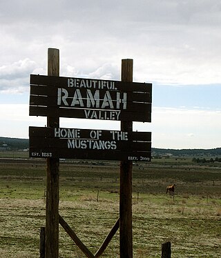
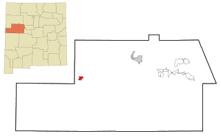
Ramah is an unincorporated community and census-designated place (CDP) in McKinley County, New Mexico. The population was 461 as of the 2020 United States census.

The Cibola National Forest is a 1,633,783 acre United States National Forest in New Mexico, US. The name Cibola is thought to be the original Zuni Indian name for their pueblos or tribal lands. The name was later interpreted by the Spanish to mean "buffalo". The forest is disjointed with lands spread across central and northern New Mexico, west Texas and Oklahoma. The Cibola National Forest is divided into four Ranger Districts: the Sandia, Mountainair, Mt. Taylor, and Magdalena. The Forest includes the San Mateo, Magdalena, Datil, Bear, Gallina, Manzano, Sandia, Mt. Taylor, and Zuni Mountains of west-central New Mexico. The Forest also manages four National Grasslands that stretch from northeastern New Mexico eastward into the Texas Panhandle and western Oklahoma. The Cibola National Forest and Grassland is administered by Region 3 of the United States Forest Service from offices in Albuquerque, New Mexico. Elevation ranges from 5,000 ft to 11,301 ft. The descending order of Cibola National Forest acres by county are: Socorro, Cibola, McKinley, Catron, Torrance, Bernalillo, Sandoval County, New Mexico, Lincoln, Sierra, and Valencia counties in New Mexico. The Cibola National Forest currently has 137,701 acres designated as Wilderness. In addition to these acres, it has 246,000 acres classified as Inventoried Roadless Areas pursuant to the Roadless Area Conservation Rule.
Grants/Cibola County Schools (GCCS) is a school district based in Grants, New Mexico, United States.
The Zuni Indian Reservation, also known as Pueblo of Zuni, is the homeland of the Zuni tribe of Native Americans. In Zuni language, the Zuni Pueblo people are referred to as A:shiwi, and the Zuni homeland is referred to as Halona Idiwan’a meaning Middle Place.

The Ramah Navajo Indian Reservation is a non-contiguous section of the Navajo Nation lying in parts of west-central Cibola and southern McKinley counties in New Mexico, United States, just east and southeast of the Zuni Indian Reservation. It has a land area of 230.675 sq mi (597.445 km2), over 95 percent of which is designated as off-reservation trust land. According to the 2000 census, the resident population is 2,167 persons. The Ramah Reservation's land area is less than one percent of the Navajo Nation's total area.

Area code 575 is a telephone area code in the North American Numbering Plan (NANP) for the U.S. state of New Mexico. The area code was created in 2007 in an area code split of area code 505, whose service area was reduced to the Albuquerque, Santa Fe, Farmington, and Gallup regions to provide more telephone numbers to the most populated parts of the state. Area code 575 serves the rest of the state.

The Albuquerque–Santa Fe–Los Alamos combined statistical area is made up of eight counties in north central New Mexico. The combined statistical area consists of the Albuquerque and Santa Fe metropolitan statistical areas, and the Las Vegas, Los Alamos, and Española micropolitan statistical areas. The 2013 delineations included the Grants micropolitan statistical area, but it was removed in the 2018 revisions. As of the 2020 census, the CSA had a population of 1,162,523. Roughly 56% of New Mexico's residents live in this area. Prior to the 2013 redefinitions, the CSA consisted only of the Santa Fe metropolitan statistical area and the Española micropolitan statistical area. The total land area of the Albuquerque–Santa Fe–Las Vegas combined statistical area in the 2013 definition is 26,421 sq mi (68,430 km2).

The Albuquerque Metropolitan Statistical Area, sometimes referred to as Tiguex, is a metropolitan area in central New Mexico centered on the city of Albuquerque. The metro comprises four counties: Bernalillo, Sandoval, Torrance, and Valencia. As of the 2010 United States Census, the MSA had a population of 887,077. The population is estimated to be 923,630 as of July 1, 2020, making Greater Albuquerque the 61st-largest MSA in the nation. The Albuquerque MSA forms a part of the larger Albuquerque–Santa Fe–Los Alamos combined statistical area with a 2020 estimated population of 1,165,181, ranked 49th-largest in the country.
Gallup-McKinley County Schools (GMCS) is a school district based in Gallup, New Mexico which serves students from Gallup and surrounding areas of McKinley County.
Zuni Public School District (ZPSD) is a school district headquartered in the Zuni Pueblo census-designated place of unincorporated McKinley County, New Mexico, United States.
Timberlake is an unincorporated community and census-designated place (CDP) in McKinley and Cibola counties, New Mexico, United States. As of the 2020 census, it had a population of 121.
Zuni High School (ZHS) is a public high school in Black Rock, New Mexico, with a Zuni Pueblo postal address. It is a part of the Zuni Public School District.
Ramah Middle/High School is a public secondary school in unincorporated McKinley County, New Mexico, near the Ramah census-designated place and with a Ramah postal address. It is a part of Gallup-McKinley County Schools.
Quemado Independent Schools is a school district headquartered in Quemado, New Mexico, U.S. Shelby Perea of the Albuquerque Journal described the district, located in a rural area, as being "small".