
The Leech Lake Indian Reservation is an Indian reservation located in the north-central Minnesota counties of Cass, Itasca, Beltrami, and Hubbard. The reservation forms the land base for the federally recognized Leech Lake Band of Ojibwe, one of six bands comprising the Minnesota Chippewa Tribe, organized in 1934. The Leech Lake Reservation has the highest population of any reservation in Minnesota, with a resident population of 10,660 indicated by the 2010 United States census.
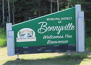
The Municipal District of Bonnyville No. 87 is a municipal district (MD) in northeastern Alberta, Canada in Division No. 12. It is located adjacent to the province of Saskatchewan on the east.

The districts of Peru are the third-level country subdivisions of Peru. They are subdivisions of the provinces, which in turn are subdivisions of the larger regions or departments. There are 1,838 districts in total.

Métis in Alberta are Métis people, descendants of mixed First Nations/native Indian and white/European families, who live in the Canadian province of Alberta. The Métis are considered an aboriginal group under Canada's Constitution Act, 1982 and separate and distinct from First Nations, and have different legal rights. Different Metis groups attempted to combine the joint influences of the Manitoba Metis Federation, the Metis Nation of Alberta, and the Metis Nation- Saskatchewan. This was done in hopes that the Metis peoples’ of Alberta would receive land and resource rights. In Alberta, unlike in the rest of Canada, Métis people have negotiated certain lands to be reserved for them under the Métis Population Betterment Act of 1938, known today as the Eight Métis Settlements. These Métis Settlements Federated in 1975 to protect existing Métis Settlement lands following the Alberta Governments dissolution, by Order-In-Council of four Métis Settlements from 1950-1960. Following legal challenges by the Federation of Métis Settlements in 1975 for the loss of natural resource against Alberta, the Crown in Right of Alberta settled out of court for a suite of legislation that would see self-government, land, and money transferred to the newly formed government of the Métis Settlements General Council (MSGC), Canada’s only Métis self-government. The Métis Settlements General Council is the legislator of the Federation of Métis Settlements. MSGC is the second largest land owner in the Province of Alberta.

Saskatoon Island Provincial Park is a provincial park located in northern Alberta, Canada. It is located 20 kilometers (12 mi) west of Grande Prairie in the Peace River Country, on the southern shore of Saskatoon Lake.

Smoky Lake is a town in central Alberta, Canada. It is located 116 km (72 mi) northeast of Edmonton at the junction of Highway 28 and Highway 855. It lies between the North Saskatchewan River, Smoky Creek and White Earth Creek, in a mainly agricultural area. The provincial historic site of Victoria Settlement is nearby. Long Lake Provincial Park is located 60 km (37 mi) north of the town. Since time immemorial, the Woods Cree, a First Nations people, named "Smoking Lake" for the smoke from ceremonies performed on the shore; the name Smoky Lake may also be based in the mist that rose from the lake in great quantities at sundown. One of its churches, the St. Onuphrius Ukrainian-Catholic, built in 1907, has been moved to the Canadian Museum of History in Gatineau, Quebec. It is in Census Division No. 12 and is the municipal office for the Smoky Lake County.
Wabasca, also known as Wabasca-Desmarais, is a hamlet in northern Alberta, Canada, within the Municipal District of Opportunity No. 17. It is located between and along the South and North Wabasca Lakes, at the intersection of highways 813 and 754. It is approximately 123 km (76 mi) northeast of Slave Lake.

Big Lakes County, formerly the Municipal District of Big Lakes, is a municipal district in north-central Alberta, Canada.

Mackenzie County is a specialized municipality in northern Alberta, Canada. It is located in Census Division 17, along the Mackenzie Highway. Incorporated as a municipal district in 1995 from the former Improvement District No. 23., its status was changed to specialized municipality in 1999 to address the particularities of managing such a large territory, which is 10% larger than New Brunswick. Mackenzie County municipal office is located in the Hamlet of Fort Vermilion. The name was changed from the Municipal District of Mackenzie No. 23 to Mackenzie County in 2007.

The County of Northern Lights is a municipal district in northwest Alberta, Canada. Located in Census Division 17, its municipal office is located in the Town of Manning.

Smoky Lake County is a municipal district in north-eastern Alberta, Canada. Located in Census Division No. 12, its municipal office is located in the Town of Smoky Lake.
Cadotte Lake is an unincorporated community in northern Alberta, Canada within Northern Sunrise County. It is located on the northern shore of the homonymous lake, along Highway 986, 79 km (49 mi) east of Peace River and 68 km (42 mi) west of the Bicentennial Highway.
Ahtahkakoop First Nation is a Cree First Nation band government in Shell Lake, Saskatchewan, Canada. The Ahtahkakoop First Nation government and community is located on Ahtahkakoop 104, 72 kilometers northwest of Prince Albert and is 17,347 hectares in size.

Kikino Metis Settlement is a Metis settlement in central Alberta, Canada within Smoky Lake County. It is located along Highway 36, approximately 128 km (80 mi) west of Cold Lake.

Gift Lake Metis Settlement is a Metis settlement in northern Alberta, Canada within Big Lakes County. It is located along Highway 750, approximately 203 km (126 mi) northeast of Grande Prairie.

Fishing Lake Métis Settlement is a Métis settlement in northern Alberta, Canada within the Municipal District of Bonnyville No. 87 and Treaty Six lands. Fishing Lake Métis Settlement was settled by inhabitants of the dissolved St. Paul des Métis settlement and served as a historic Fishing camp to Métis in the region for centuries. It is home to many historical events such as the Frog Lake Resistance and is home to the beginning of the 20th century Métis movement as led by Charles Delorme, Jack Desjarlais and J.F Dion. It is located approximately 15 km (9.3 mi) east of Highway 897 and 52 km (32 mi) south of Cold Lake.
Buffalo Lake Metis Settlement is a Metis settlement in northern Alberta, Canada within Smoky Lake County. It is located along Highway 855, approximately 125 km (78 mi) northeast of Edmonton.
