
Ushuaia is the capital of Tierra del Fuego, Antártida e Islas del Atlántico Sur Province, Argentina. With a population of 82,615 and a location below the 54th parallel south latitude, Ushuaia claims the title of world's southernmost city.

Lo Barnechea is a commune located in the northeastern sector of the province of Santiago and its area corresponds to 48% of this province. Its urban boundaries are: to the north with Los Andes of the Valparaíso region, to the west with Colina, to the southwest with Vitacura and Huechuraba, to the south with Las Condes and to the east with San José de Maipo. It developed around the old rural town of Lo Barnechea. Its population is heterogeneous, as it is inhabited by high- and medium-high-income families in sectors such as La Dehesa, Los Trapenses and El Arrayán, and also by medium-low- and low-income families, mainly in the towns of Lo Barnechea, Población La Ermita and Cerro Dieciocho.

LADE - Líneas Aéreas del Estado is an airline based in Comodoro Rivadavia, Argentina. It is a state owned airline operated by the Argentine Air Force and provides domestic scheduled services mainly in Patagonia.

Cerro Catedral is a mountain located 19 kilometres (12 mi) from San Carlos de Bariloche, and inside the Nahuel Huapí National Park, in Patagonia, Argentina.
San Martín de los Andes is a city in the south-west of the province of Neuquén, Argentina, serving as the administration centre of the Lácar Department. Lying at the foot of the Andes, on the Lácar lake, it is considered one of the main tourism destinations in the province. The National Route 40 runs to the city, connecting it with important touristic points in the south of the province, such as Lanín and Nahuel Huapí national parks.

El Calafate, also known as Calafate, is a city in Patagonia, Argentina. It is situated on the southern border of Lake Argentino, in the southwest part of the Santa Cruz Province, about 320 kilometres (200 mi) northwest of Río Gallegos. The name of the city is derived from a little bush with yellow flowers and dark blue berries that is very common in Patagonia: the calafate ; the word comes from the word calafate, which is Spanish for 'caulk'.

The protected areas of Chile are areas that have natural beauty or significant historical value protected by the government of Chile. These protected areas cover over 140,000 km2 (54,054 sq mi), which is 19% of the territory of Chile. The National System of Protected Wild Areas is regulated by law #18,362 passed in 1984, and administered by the National Forest Corporation (CONAF).

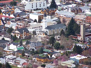
Panguipulli is a city and commune in Valdivia Province, southern Chile, administered by the Municipality of Panguipulli. It is located on the western edge of Panguipulli Lake, and is on a moraine in the Chilean Central Valley. Most of the commune lies on Andean mountains and valleys.
Nevados de Chillán is a group of stratovolcanoes located in the Andes of Ñuble Region, Central Chile, and is one of the most active volcanoes in the region. It consists of three overlapping peaks, 3,212 m (10,538 ft) Cerro Blanco at the northwest and 3,089 m (10,135 ft) Volcán Viejo at the southeast, with Volcán Nuevo in the middle. Volcán Viejo was the main active vent during the 17th-19th centuries, and the new Volcán Nuevo lava dome complex formed between 1906 and 1945, eventually growing to exceed Viejo in height by the mid 1980s.

The Climate of Venezuela is characterized for being tropical and megathermal as a result of its geographical location near the Equator, but because of the topography and the dominant wind direction, several climatic types occur which can be the same as found in temperate latitudes, and even polar regions. Latitude exerts little influence on the Venezuelan climate. While the coastal cities of Maracaibo, Barcelona, Porlamar and Maiquetia can get extremely hot, cities in valleys such as Mérida, Caracas, Los Teques and San Cristobal have cooler climates, and the highest towns of Mucuchies and Apartaderos have cold (tundra) climates.
Hiking in Chile is characterized by a wide range of environments and climates for hikers, which largely results from Chile's unusual, ribbon-like shape, which is 4,300 kilometres long and on average 175 kilometres wide. These range from the world's driest desert, the Atacama, in the north, through a Mediterranean climate in the center, to the glaciers, fjords and lakes of Patagonia in the south.

Cerro Castor is a ski resort on the southern slope of Mount Krund, 26 kilometres (16 mi) from the city of Ushuaia, in the Argentine province of Tierra del Fuego. Its tracks can be used during several months because of the cold weather of the region. The standard season takes place between June and October, and it is, thanks to the geographic location, the longest among the main ski centers in Argentina. Cerro Castor is the southernmost ski resort in the world.

Farellones is a village and ski resort located 36 km from Santiago, Chile. It was founded during the 1930s, nestled in a small valley in the Andes mountains close to other ski areas such as Valle Nevado, La Parva, and El Colorado.
María Cecilia Domínguez is a cross-country skiing player and technical drawer from Argentina.

